


gabel23
-
Posts
2304 -
Joined
-
Last visited
-
Days Won
5
Everything posted by gabel23
-

GHD III Winter Storm Possibility, Feb. 1st-3rd
gabel23 replied to Geos's topic in East of the Rockies
I'm thinking the Euro is playing catch-up, by tonight or tomorrow hopefully it starts showing what the GFS has been showing for like the past 4 days...... -
GHD III Winter Storm Possibility, Feb. 1st-3rd
gabel23 replied to Geos's topic in East of the Rockies
That still looks like a tight gradient for snow....I'll take the GFS please....... -
GHD III Winter Storm Possibility, Feb. 1st-3rd
gabel23 replied to Geos's topic in East of the Rockies
That is a perfect track for Eastern Neb/Western Iowa. I would like to see the snowfall maps! -
GHD III Winter Storm Possibility, Feb. 1st-3rd
gabel23 replied to Geos's topic in East of the Rockies
Thank you King Euro!! Now lets hold our positions, the Canadian can hopefully get thrown out too or come join the GFS and Euro. -
GHD III Winter Storm Possibility, Feb. 1st-3rd
gabel23 replied to Geos's topic in East of the Rockies
OMG I hate the Euro, it looks like the deformation zone is extremely narrow. Hoping Euro is out to lunch on this one. -
GHD III Winter Storm Possibility, Feb. 1st-3rd
gabel23 replied to Geos's topic in East of the Rockies
Nothing is solid until the snow is flying!! Been burned too many times, I'll feel good when watches and warnings are out......I'm loving the consistency though, hoping euro follows suit. -
Still around 2-3" of snow on the ground, will be interesting to see if the ditches and drifts survive the melt. We have some drifts that are 3-5' and ditches are full of snow.
-
GHD III Winter Storm Possibility, Feb. 1st-3rd
gabel23 replied to Geos's topic in East of the Rockies
Best run yet for me, I'll take it!! Nice little lollipop 16+ right over head, if only we could lock it in.... -
GHD III Winter Storm Possibility, Feb. 1st-3rd
gabel23 replied to Geos's topic in East of the Rockies
Everyone keeps talking about this storm going further southeast, well Sioux Falls thinks if anything the track may be further north than anything else.... STILL TRACKING A LARGE UPPER LOW EARLY NEXT WEEK...PRIMARILY FROM LATE MONDAY NIGHT THROUGH WEDNESDAY MORNING...WITH TUESDAY AND TUESDAY NIGHT THE PRIMARY FOCUS PERIODS. THE OPERATIONAL GFS...GEM GLOBAL AND ECMWF HAVE ALL NOW COALESCED AROUND A SOLUTION WHICH TAKES A BULK OF THE WAVE ACROSS THE CENTRAL PLAINS WHICH WOULD MAINLY AFFECT OUR SOUTHERN AND EASTERN ZONES WITH SNOW...LESS SO IN OUR NORTHWEST AROUND HURON AND CHAMBERLAIN. THERE IS SO MANY QUESTION MARKS REGARDING THIS SYSTEM AT THIS TIME. WILL THE UPPER AND SURFACE LOWS TRACK FURTHER NORTH AS THE MODEL BIAS USUALLY HAS A TENDENCY TO TRACK THE LOW TOO MUCH EASTWARD INTO THE DOWNSTREAM RIDGE. THIS HAPPENED IN NOVEMBER AND DECEMBER. HOW UNSTABLE IT WILL GET IS A HUGE QUESTION MARK. IN NOVEMBER AND DECEMBER WE HAD UNSTABLE EVENTS ESPECIALLY IN THE MID LEVELS. LASTLY...WILL A SOLID LINE OF CONVECTION DEVELOP OVER THE GULF COAST STATES AND OHIO VALLEY TOO FAR AHEAD OF THE UPPER LOW...WHICH COULD SHUTOFF OUR WARM MOIST CONVEYOR BELT OF MOISTURE. IN MARCH OR EARLY APRIL...THIS LAST SITUATION WOULD BE LESS OF A PROBLEM WITH MORE OVERALL MOISTURE AVAILABLE. IT STILL LOOKS LIKE NORTHWEST IA AND IMMEDIATE ADJACENT AREAS COULD RECEIVE A SUBSTANTIAL SNOWFALL WITH ITS CURRENT TRACK. IF ANYTHING...BELIEVE THE UPPER LOW WILL TRACK MORE NORTHWARD IN FUTURE MODEL RUNS AS IT MOVES UP AND OVER THE DOWNSTREAM RIDGE MORE THAN WHAT IS BEING SHOWN RIGHT NOW. THEREFORE THAT COULD POTENTIALLY MAKE THE SNOWFALL HEAVIER FOR A BIGGER PART OF OUR AREA. ONE THING IS MORE CERTAIN...SURE GETS COLDER AGAIN BEHIND THIS SYSTEM WITH ONLY TEENS AND LOWER 20S NEXT WEDNESDAY. -
GHD III Winter Storm Possibility, Feb. 1st-3rd
gabel23 replied to Geos's topic in East of the Rockies
I really don't like that map, please throw it out! Gives me nothing, has to be Jim Flowers because it looks like today's EURO run. -
GHD III Winter Storm Possibility, Feb. 1st-3rd
gabel23 replied to Geos's topic in East of the Rockies
Will be interesting to see how much this moves as we near the event.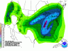
-
GHD III Winter Storm Possibility, Feb. 1st-3rd
gabel23 replied to Geos's topic in East of the Rockies
Have to expect this though considering we are a long ways out yet. I just hope it swings back for us as the event nears. -
GHD III Winter Storm Possibility, Feb. 1st-3rd
gabel23 replied to Geos's topic in East of the Rockies
I don't like that map, way sharper of a cut off on snow totals. I'm getting on the edge of the deformation band, hoping the GFS wins out again.... -
GHD III Winter Storm Possibility, Feb. 1st-3rd
gabel23 replied to Geos's topic in East of the Rockies
Yikes that's way less QPF, should have good ratios with temps that low but man no more shifting please! -
GHD III Winter Storm Possibility, Feb. 1st-3rd
gabel23 replied to Geos's topic in East of the Rockies
What's it look like for us? I can't see your maps! -
GHD III Winter Storm Possibility, Feb. 1st-3rd
gabel23 replied to Geos's topic in East of the Rockies
Which means if the EURO holds true than every major long range model is pretty much in agreement with 7 days to go....... -
GHD III Winter Storm Possibility, Feb. 1st-3rd
gabel23 replied to Geos's topic in East of the Rockies
We have a 5-8" snow pack in parts of Eastern/Southeast Nebraska, although I would expect most if not all of the snow to be gone by this weekend. The snow pack has a weird glaze to it around my area, almost like it's completely crusted over/frozen. I'm hoping that can lncrease the albedo affect, I want to keep some of my snowpack! -
GHD III Winter Storm Possibility, Feb. 1st-3rd
gabel23 replied to Geos's topic in East of the Rockies
I just need to stop watching the models because I have been sitting in the sweet spot for way to long. I just hope I don't get really disappointed.....been a while since I have seen a monster. -
GHD III Winter Storm Possibility, Feb. 1st-3rd
gabel23 replied to Geos's topic in East of the Rockies
I'm thinking a pretty good swath of 12+ setting up shop somewhere through Central Nebraska and on east...... -
GHD III Winter Storm Possibility, Feb. 1st-3rd
gabel23 replied to Geos's topic in East of the Rockies
Anybody have the snow totals from the EURO? -
GHD III Winter Storm Possibility, Feb. 1st-3rd
gabel23 replied to Geos's topic in East of the Rockies
OMG That's a lot of snow!!!!! Too bad it's still 7 days away......... -
GHD III Winter Storm Possibility, Feb. 1st-3rd
gabel23 replied to Geos's topic in East of the Rockies
How about KOLU?? Thanks. -
GHD III Winter Storm Possibility, Feb. 1st-3rd
gabel23 replied to Geos's topic in East of the Rockies
I'm just not liking the fact we are sitting in a sweet spot with a week to go. Although I'm fine with the GFS shifting to the southeast because that would put me further into the sweet spot for snow. Just no major shift please!!! -
Midwest Snowfall Contest for the Winter of 2015-16
gabel23 replied to Geos's topic in East of the Rockies
This will go down as one of the toughest forecasted winters around are parts in a while. That is quoted from a meteorologist out of lincoln, we have had 6 surprise snowstorms or over achievers in my area since x-mas. I have had a white thanksgiving, x mas, and new years for the first time since I can remember. I have had snow on the ground pretty much since a week before x mas, and my current snow depth is at 5". If we can avoid too much of a melt off from the heat wave coming in this week, I might go into March with snow on the ground. That might be a guarantee if that storm next week comes anywhere close to it's predicted totals. Overall, I'm pretty impressed with this strong El-Nino winter...hard to believe that some in Nebraska have had very little in the way of snow. -
GHD III Winter Storm Possibility, Feb. 1st-3rd
gabel23 replied to Geos's topic in East of the Rockies
I know, it's incredible how consistent this thing has been showing up on the models. Didn't the groundhog blizzard in Chicago have the same thing happen?? We all know how that thing turned out, I would like to see something like that roll through our area.

