


gabel23
-
Posts
2296 -
Joined
-
Last visited
-
Days Won
5
Everything posted by gabel23
-
Well; I don't want to be selfish and say I'm jealous of what happened in Central Nebraska. Congrats out there; I got 6.5" of snow in pretty much 6 hours. I was worried that dry air/sleet was gong to cut into my chance at snow. Once it started it came down in buckets. I feel bad for those of you who missed out and that sucks about JIm. Forecasting snow is the hardest thing in the world and I can't believe how many mets are taking heat. They don't need that! LASTLY, SHOUT OUT TO THE NAM! It was pretty darn spot on with the storm within 48 hours; it was really the only one showing the dry air/dry slot showing up in Southeast Neb. It pretty much nailed my forecast. The GFS/Euro/Canadian all had me getting 12+.
-
What’s that band doing over you now and how’s the wind?? Snow has stopped here and wondering what that band will bring!
-
It’s been a crazy day here. I seen snowfall rates of one to 2 inches an hour for a solid four hours. Just when I thought the dry air would win out, we now have switched back over to heavy snow. roughly eye balling 5” here and hoping to continue to add to the amount. Hastings seem to think so. They had a great disco today. Glad you did well! Elsewhere, likely looking at another 1-3hr of hvy snow for most areas between Hwy 6 and Hwy 92. By 6-7PM, the best snw accums will have shifted to areas along and N of Hwy 92 where another 3-4" will be possible. Areas along I-80 can expect about another 1-2". When all is said and done, based on current reports and ideas outlined above...think a significant portion of the CWA along and north of a line from HDE to GRI to OLU will have 12-18" of snow, perhaps higher in the ODX area. Even Hastings, which was essentially snow free thru noon, may wind up with 10-12", which would be very impressive. No other way to put it besides saying this is one of the most intense bursts of snow this forecaster has experienced in this area - particularly in terms of snow rates AND duration of high snow rates. IMG_2335.MOV
-
Talked to a buddy of mine who lives in Lincoln he said they have running water down the streets!
-
IMG_2332.MOV Finally transitioned over to snow about 12:45! That was something to see. We slowly went from graupel and ice pellets, with flakes slowly mixing in. Then boom, flakes got huge and it's just puking snow! Big old fat flakes falling.
-
Freezing drizzle has glazed everything over. No matter how much snow we get, I’m hoping for 10, it’s gonna be some difficult travel. Patiently waiting for the transition to snow.
-
Wow ground looks great, still have brown grass here. Enjoy!
-
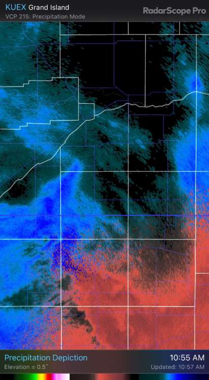
Not liking the way radar and short range models look for my area. I’m getting pellets and Graupel at the moment. Look at this radar, dry hole plugging away…..hope it fills in fast.
-
Yeah Tom, I’m on the eastern end of the heaviest snow line. The euro would give me between 13-17”. I’m hoping for 10+ and I will be completely happy! Looks like this thing might be historic, it’s just crazy that we’re going to see this amount of snow in a short period of time!
-
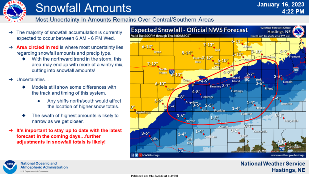
I just had time to read the disco from earlier this afternoon from GID Hastings, not being picky but wow what a paragraph! This event will be a high-end winter system for our forecast area, and impacts are likely to be felt through at least Thu, and likely even into Fri for rural areas that receive heavy snow. Our in-house "Blizzard Severity Index" is a solid 3-3.5 (on scale of 0-5) for areas with heaviest snow. Only missing factors to a more historic blizzard are 5-10 MPH stronger gusts and colder temps. More well-known Winter Storm Severity Index (WSSI) is also impressive, with widespread "Major" impacts from SW to NE Neb., and a sizable area of "Moderate" impacts surrounding it.
-
This would take insane snowfall rates to come true. Most models are consistent with showing the heavy axis and less dry air/sleet. Gonna be an interesting morning to say the least.
-
I pray that this spreads the wealth to the rest of you that misses out tomorrow. Everyone is over due and that would just make the rest of the winter go so much better!
-
Well look at that bullseye right over my county!!! I'm excited to see this play out tomorrow. If I get 6+ it will be my biggest storm in over two years.
-
Last time I can recall was in March of 2006. I got 2 feet of snow, places out by ord got 30”. I think you’re right though 2 ft might be a little high. Will see, I’ll gladly take what we can get.
-
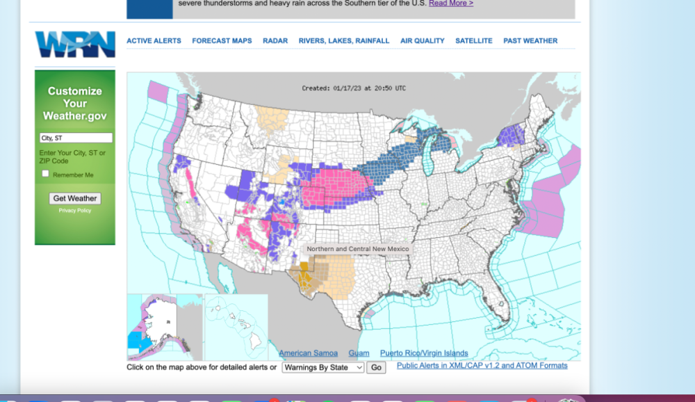
Been a very long time since I have seen a map like this. Nearly the entire state of Nebraska is under a WSW. Lastly, here is what's being forecasted in Central Nebraska at Ord. Pretty impressive stuff! Tonight Snow likely, mainly after 5am. Cloudy, with a low around 22. Northeast wind 5 to 15 mph, with gusts as high as 25 mph. Chance of precipitation is 60%. New snow accumulation of less than one inch possible. Wednesday Snow. The snow could be heavy at times. Widespread blowing snow, mainly after 5pm. High near 25. Blustery, with a north northeast wind 15 to 20 mph, with gusts as high as 30 mph. Chance of precipitation is 100%. New snow accumulation of 10 to 16 inches possible. Wednesday Night Snow, mainly before midnight. Patchy blowing snow. Low around 16. Blustery, with a north wind 20 to 25 mph, with gusts as high as 35 mph. Chance of precipitation is 90%. New snow accumulation of 1 to 3 inches possible.
-
That’s looking good. Great to see euro on my side, just outside the 12+ by sixty miles. Just hate seeing that sharps cutoff of the south. Onto the nam.
-
Ugg never fails, can't ever get a slam dunk for my area. This has the potential to turn into a bust or magical storm. Will see what tonights runs show. Hoping they jump on the GFS board!
-
Bullseye by the euro for areas along and east of highway 281; aka eastern half of Nebraska and only four days out. What could go wrong? I’ll give the models one thing, it seems they are coming in agreement with the track. Strength and moisture seems to be the play.
-
OK, still a long ways to go, but I would love to see the models keep coming in stronger. Seems like for the past couple years as we get closer and closer to the event the models go the other way. Here’s to hoping we see a more widespread weather system for all!
-
Crazy stuff being reported in Columbus and Grand Island. Factory effect snows being reported and my wife is witnessing it in Columbus!
-
Absolute insane drive out west!
-
My side business is mowing. Just letting you know if you have a wet year and a pile of leaves in your yard you are gonna see ground rot!
-
A little behind schedule but this would match up with the Nov. 15th to Nov. 17th storm. We had a major trough move thru the central plains and it brought the first snows to many on the forum. We had a major temp change in our area and dropped 30 degrees below average. Now, at that time both NAO and AO were neutral. It will be interesting to watch how it fairs this time around.


