


bud2380
-
Posts
5977 -
Joined
-
Last visited
-
Days Won
11
Everything posted by bud2380
-
I wouldn’t trust the NAM at all. All other guidance is further south including recent runs of the RAP and HRRR
-
NAM shifting north again.
-
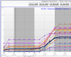
15Z SREF plume for Cedar Rapids shows a 4" average. A high of about 7", low of basically 0.
-
18z NAM shifted south from the 12z run and is now in line with every other model. Looks like I got an inch today. Snow came down pretty good at the tail end.
-
I’m still able to access the Euro on wxgraphics. Here is the Euro
-
4"+ for my back yard. I'd be very happy with this. I think we'll see advisories issued this afternoon from DMX and DVN to cover a good chunk of Iowa http://maps1.pivotalweather.com/maps/models/gfs/2017122812/036/snku_024h.us_mw.png
-
GFS actually has the heaviest bands south of I80 tomorrow in E Iowa. I'm discounting the NAM personally as it's by far the furthest north model.
-
Must be a lot of dry air over my area, because despite the radar returns, nothing is falling. We got a dusting overnight.
-
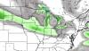
http://maps3.pivotalweather.com/maps/models/rgem/2017122812/036/snku_024h.us_mw.png
-
RGEM is further south than the NAM tomorrow and more widespread. The NAM has an extreme cutoff on the south. I haven't seen other models with as sharp a cut off yet.
-
NAM is further north with tomorrow’s system than other models. Clips my area. Hopefully for my sake that is just the NAMs normally north bias.
-
NAM, Euro, and now GFS all in very good agreement with a stripe of 2-4” for our neck of the woods Friday.
-
DVN completely punted on the Friday forecast in the AFD.
-
Looks to start after noon on Friday per the euro.
-
Those GFS maps make no sense. COD must be using 50:1 ratios to get those snow amounts.
-
Euro has a stripe of .1-.2” qpf directly through Iowa City and Cedar Rapids Friday. With high ratios could be a 2-4” event. I’ll hold my breath.
-
A number of short term models are showing a band of heavier snow developing in western and SW Iowa tonight. Seems to dry up a bit as it heads east though.
-
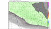
The NAM has the Friday system cutting through the heart of Iowa. Similar to the Euro. http://maps1.pivotalweather.com/maps/models/nam/2017122618/084/snku_024h.us_mw.png
-
Euro finally showing a larger scale system from the SW in the day 8-10 time period. At least the models are active. Not that its amounted to much of anything.
-
Euro keeps the heavier snow well into MN again this run for Wed night/Thursday. Looks like less than an inch here. Friday evening's system looks stronger right now and further north than the GFS. That one could lay down 1-3" wherever it ends up.
-
GFS good hit for St. Louis and northern Missouri for the weekend system. But considering how bad it seems to be handling the Thursday event, I'm not putting much into it right now.
-
Friday's event is a thread the needle type system on the GFS. Looks like about 50-75 mile swath is all. Saturday is looking to be decent for Nebraska, but then either dries out or heads south from there.
-
2.3" for Iowa City I guess verbatim, but given the evolution of this storm, that seems overdone. http://maps1.pivotalweather.com/maps/models/gfs/2017122612/060/snku_acc.us_mw.png
-
yep, GFS with a big jump north. now in line with most of the other models. Still drops an inch or so down my way, but nothing like the 3-5" it had been showing for the past 3 days.
-
NAM continues to be way north of the GFS. Like a couple hundred miles. Stunning really considering this event is now about 36 hours from breaking out snow. I have a feeling the GFS will be more wrong than right.


