-
Posts
5976 -
Joined
-
Last visited
-
Days Won
11
Everything posted by bud2380
-
3.5” down so far. Snow stopped for a bit overnight. Picking back up now. Decent rates right now but gonna need heavier rates to really push accumulations. 6-8” still seems on track.
-
This dry slot looks like it means business. Hope it fills in soon.
-
2” on the nose here so far.
-
Impressive so far. Bodes well for the storm total.
-
I have about a half inch on my sidewalk. I’ll get a more accurate measurement after the game
-
-
I’d still be really happy with this.
-
Snow has begun at my house! Just pulled in and flakes started to fall
-
Here's our storm.
-
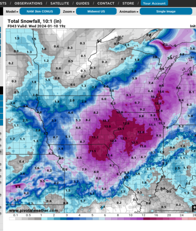
21z RAP just hammers SE Iowa and Western/Northern IL.
-
The only model I have seen that is showing these totals is the HRRR and the seldom discussed NSSL. Both CAM models. So IF they are expecting a significant amount of convection, perhaps these models are on to something. But color me skeptical.
-
GFS
-
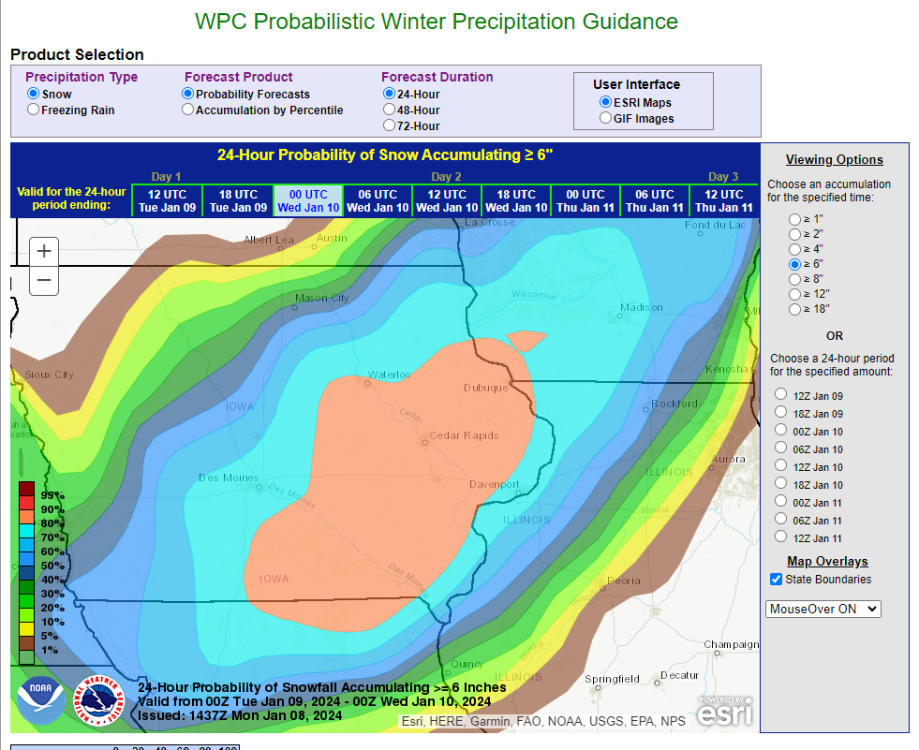
Snowfall Amounts: This event, if it pans out like projected would be a once in a 10 or 12 year single snow storm event for the area. After looking at a multitude of methods old and new(some listed above), have gone with widespread 10-15 inches along and generally west of a line from Keosauqua IA, to just east of the Quad Cities, and to Freeport IL. 8-14 inches would be a general cover of most of the CWA, except for a sharp gradient drop-off to 3-7 inches along and southeast of a line from Carthage in west central IL, to Monmouth IL, and to Princeton IL. These lesser areas may get more rain-snow mix with bouts of WAA at times tonight, and a midnight decrease or temporary dry slot as well if current storm track verifies.
-
I'm not seeing that graphic. Wonder if they took it down, because there's no effing way. LOL.
-
DVN is showing 10:1 or greater ratios. We're mostly using kuchera here, but perhaps the 10:1 maps will be more accurate. The WAA tonight will be fed by unseasonable precipital water feed(PWATs) of 0.60 inches 150-200% of normal for this time of year. Fcst soundings and comparing them to upstream trends suggest top- down deepening saturation, with low to mid level saturation depths up over H6 mb late tonight through at least late Tue morning, including the -12 to -18C dendritic layer. The incoming amount of lift by a closed off low pressure complex utilizing this saturation depth by rule should wring out up to double the amounts of the PWAT values, thus 0.60 goes to 1.2 inches of liquid equivalent. Most of it probably being snow that translates into a foot with just base 10:1 LSRs, and that may be low with probably LSR`s varying from 10 to 12:1 along prime forcing/saturation swaths. THey will trend higher to 13:1 or higher later in the event with in-wrapping cold conveyor into departing def zone, but that will be past the time of the occurrence of the heavy snow producing processes
-
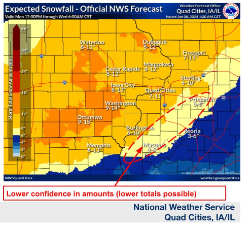
Just released Winter Storm Warning update by DVN. 9-14" Winter Storm Warning URGENT - WINTER WEATHER MESSAGE National Weather Service Quad Cities IA IL 257 PM CST Mon Jan 8 2024 IAZ040-041-051-052-063-064-076-077-087-088-098-099-MOZ009-010- 090500- /O.CON.KDVN.WS.W.0001.240109T0000Z-240110T0600Z/ Buchanan-Delaware-Benton-Linn-Iowa-Johnson-Keokuk-Washington- Jefferson-Henry IA-Van Buren-Lee-Scotland-Clark- Including the cities of Independence, Manchester, Vinton, Cedar Rapids, Marengo, Iowa City, Sigourney, Washington, Fairfield, Mount Pleasant, Keosauqua, Fort Madison, Memphis, and Kahoka 257 PM CST Mon Jan 8 2024 ...WINTER STORM WARNING REMAINS IN EFFECT FROM 6 PM THIS EVENING TO MIDNIGHT CST TUESDAY NIGHT... * WHAT...Heavy snow expected. Total snow accumulations of 9 to 14 inches. Winds could gust as high as 40 mph Tuesday afternoon through Tuesday night leading to considerable blowing and drifting snow. * WHERE...Portions of east central, northeast and southeast Iowa and northeast Missouri. * WHEN...From 6 PM this evening to midnight CST Tuesday night. * IMPACTS...Travel could be very difficult to impossible. Blowing snow could significantly reduce visibility. The hazardous conditions could impact this evening`s commute, and more likely the commutes Tuesday into Wednesday morning. * ADDITIONAL DETAILS...A long duration snow event with two to three periods of heavy snow is expected. Amounts up to a foot of snow are likely.
-
I'm not sure why the NWS does dumb things like this. Look at this forecast for my backyard. Taken verbatim that's 11-19" of snow, which is just not realistic at all. Makes no sense. I'm smart enough to know that, but other people who don't know anything about the weather are going to be telling people we might get 19" of snow.
-
-
-
18z HRRR continues to lay down impressive totals in Eastern Iowa.
-
Euro is pretty lame.
-
Only 1/10" difference on the 12z Euro vs. 6z Euro for Iowa City and Cedar Rapids. Barring a late minute shift the heaviest band in Iowa looks like it will setup just south of Iowa City.
-
Extremely heavy rates between 6am and 9am just SE of iowa City into the Quad Cities. That's looking like the sweet spot on the Euro. Just southeast of Ottumwa up to the Quad Cities and Clinton, IA.
-
Euro with heavy rates between 3am and 6am.
-
Difficult to post the Ukie in just a 24 hour interval here, but here is one snapshot.


