bud2380
-
Posts
5976 -
Joined
-
Last visited
-
Days Won
11
Everything posted by bud2380
-
Crazy, and for days you looked like you were gonna get missed altogether. HRRR shows another 4" yet to fall in Sioux Falls, so you may have over a foot by the time its all said and done.
-
Some big returns already in Sioux Falls. @hawkstwelve how much you got?
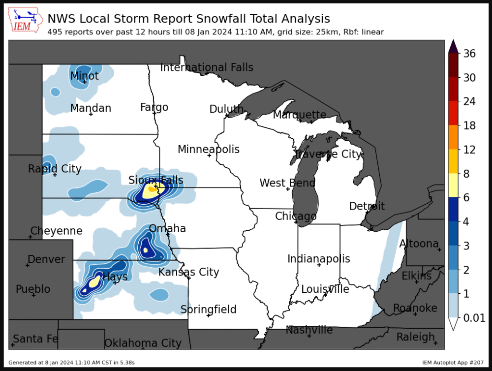
-
No real change on the 16z RAP vs 15z through 7am tomorrow.
-
The RAP at 7am tomorrow (where the model ends on the 16z run) shows heavy snow rates in SE Iowa including up to Cedar Rapids. This could be when accumulations really ramp up.
-
I'll post the CAMs just in case they weren't previously. Some pretty impressive totals. If we truly get convective snow in spots, we could see some isolated areas with these heavier totals. FV3 WRF-NSSL ARW
-
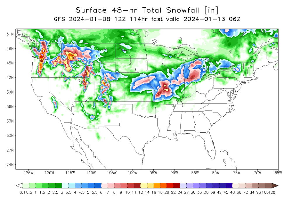
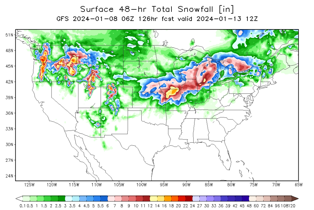
Such a long duration event, can't catch the whole midwest/GL regions in just a 24 hour map, so again here is 48 hours. Northern Missouri still favored.
-
15z RAP
-
Current temps at 10am HRRR forecast - pretty spot on. For Iowa of course.
-
Canadian seeing that south shift too. Still in that 6-8" zone for Cedar Rapids though.
-
The RAP has shifted dramatically south from just a few hours ago. The 15z will be the full run, the 14z only goes to 21 hours.
-
GFS right in that 6-8" wheel house we talked about for Cedar Rapids.
-
GFS is further south. Blasts KC.
-
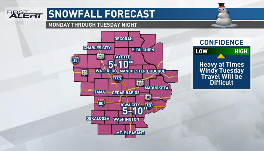
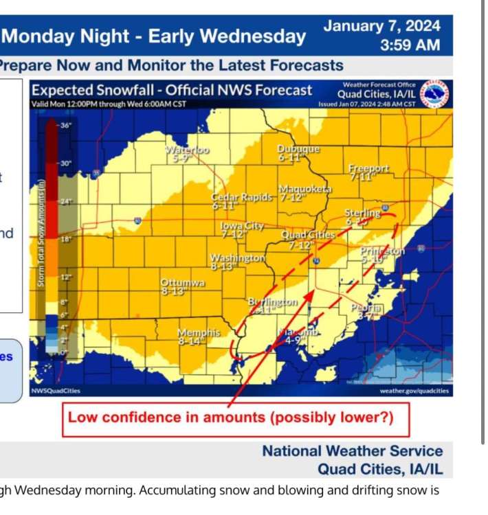
KWWL's forecast. A Storm Track 7 RED ALERT DAY is in effect from early this evening through late Tuesday night. Significant, high-end snowfall accumulations are expected across the entire area as very strong winds lead to low visibility and near-blizzard conditions. Travel will be very difficult and dangerous. Expect widespread school and business closures. Plan ahead if you have to travel. Overall accumulations will fall into a 9 to 13” range (yes, a foot or more of snow is possible) from near Tama to Elkader and all areas south. North of that line will fall into a 5 to 9” range.
-
KCRG going with 5-10" area wide.
-
I also lean more conservative, unless we get one of those ideal situations where the flake size is large and can accumulate rapidly. Not sure if that will be the case with this one or not. With winds expected to be fairly strong, flake size will likely be cut down, which could reduce snow totals as well. I think 6-8" is a good call, but to be an optimist and differ slightly, I'll go 7-9".
-
HRRR shows 7" of snow falling in Iowa City between 6am and noon tomorrow.
-
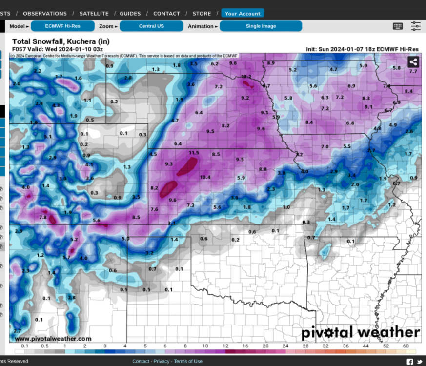
Pivotal doesn't do 48 hour snow maps, I wish they would. Here is from instantweathermaps.com that shows 48 hour snowfalls.
-
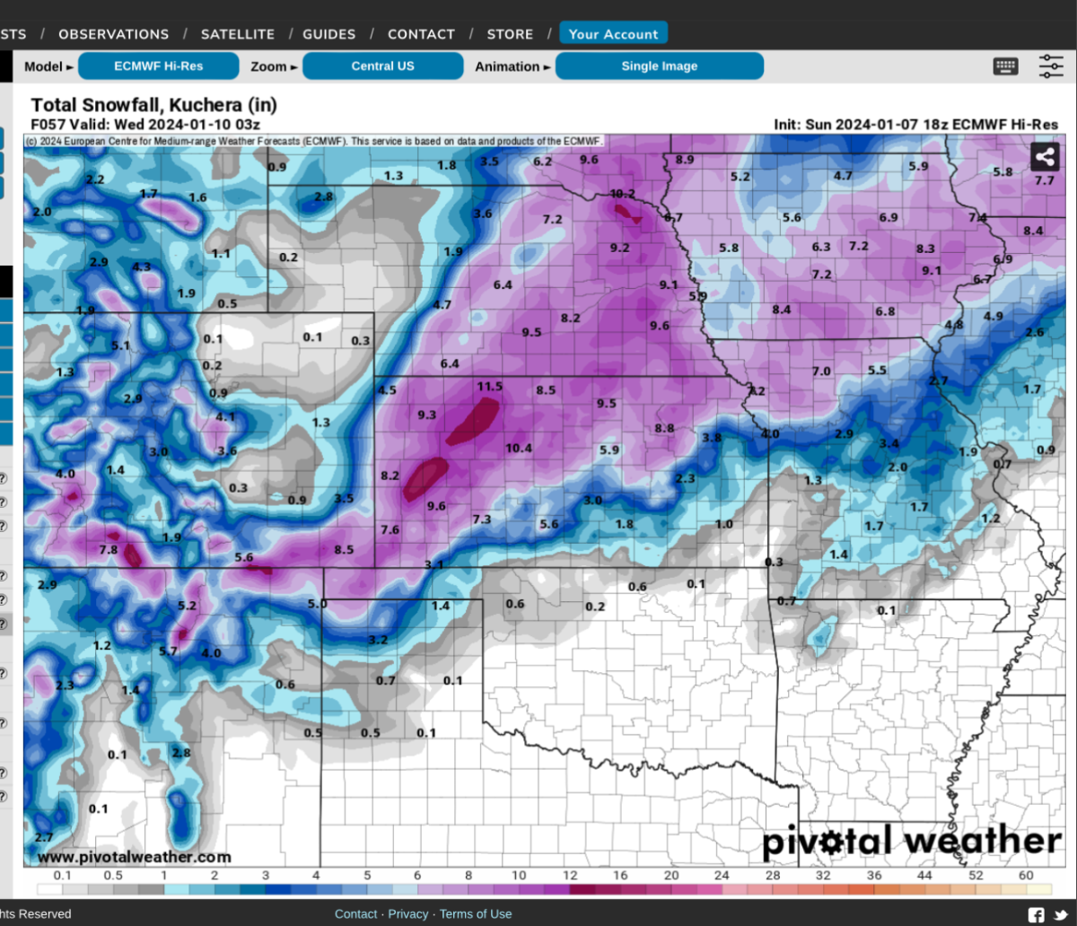
18z Euro has 1.1” qpf in Iowa City. Highest total in the state.
-
DVN very bullish on totals.
-
I’ve seen the NAM do stuff like this for years. And it’s extremely rare that it ends up being correct. I’d be very willing to wager that this is way too far north with the SLP
-
-
21z SREF
-
Could see watches hoisted this afternoon based on latest guidance.
-
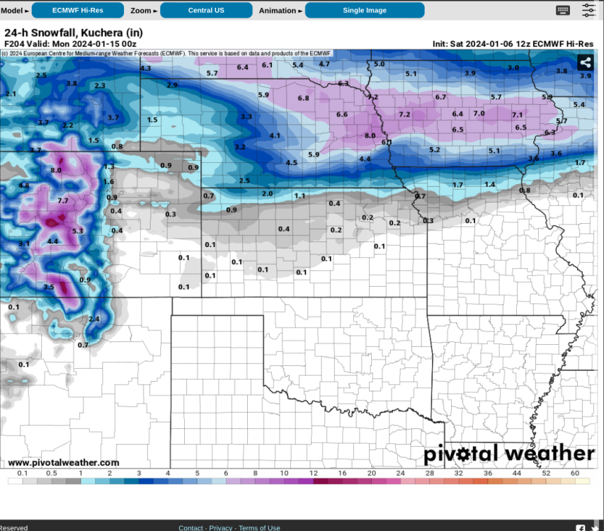
Euro shows another system next Saturday/Sunday instead.
-
Wow. What a change here in the IC/CR area. 8-10”. I know it’s 10:1 but still huge jump.