

BLI snowman
-
Posts
16253 -
Joined
-
Last visited
-
Days Won
38
Posts posted by BLI snowman
-
-
8 minutes ago, Cascadia_Wx said:
All the Hawaii talk tells me it was a decent 12z Euro run.
If the 12z Euro works out then we will clinch a VERY chilly March.
-
 5
5
-
 1
1
-
-
Just now, the_convergence_zone said:
South side. Any tips? I've been to the big island and Maui but not Kauai.
Waimea Canyon is a must. Would highly recommend trying to do a Nāpali coast boat tour as well.
-
7
-
-
6 minutes ago, TT-SEA said:
But after 300 hours the EPS shifted way west of its 00Z run. Coast to coast troughing.
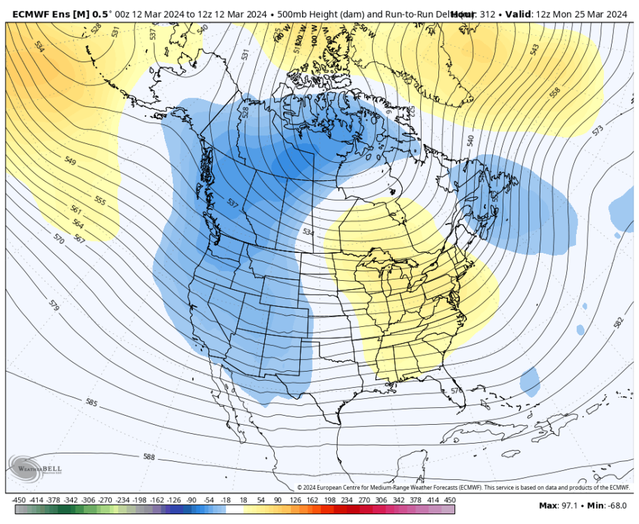
Might end up being the 2nd coldest airmass of the season for some of those Plains folk.
-
12 minutes ago, bainbridgekid said:
Funny. The Wikipedia article for Maple Bars is five sentences long and one of them is "Time Horton's and other Canadian doughnut shops do not sell maple bars."
Pretty ironic that Canada doesn't do them.
Also utterly depressing, and dare I say rather 3rd world.
-
2
-
 1
1
-
-
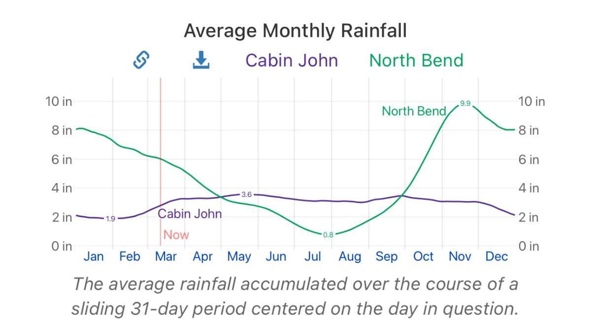
21 minutes ago, Phil said:
I see why Tim craves that little slice of summer now. D**n that’s a lot of water.
Also interesting how the lags in seasonality reverse from fall to spring.

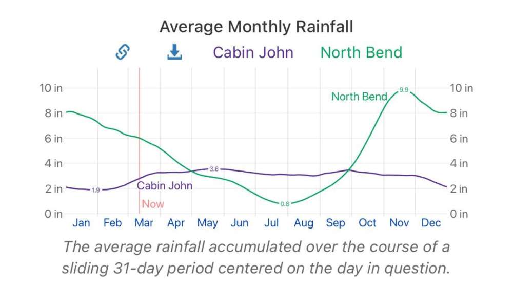
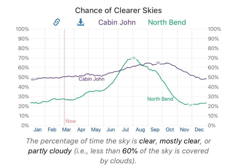
Today after 15 years of obsessively following its climate, Phil learned that it does, in fact, rain a lot in North Bend, WA.
-
3
-
-
7 minutes ago, Phil said:
Interesting.
Lots of simplistic and dumb things there, but one thing that jumped out to me was the comparing of the Ketchikan/Prince Rupert area to Germany. Very odd.
Ketchikan is fully oceanic and averages 150" of precip per year and the wettest parts of Germany are humid continental climates that average 50-60" down towards the foothills of the Alps.
The coastline of Norway (near and north of Bergen) is a very good comparison to the Ketchikan and Prince Rupert areas.
-
2
-
-
22 hours ago, Front Ranger said:
Don't forget Percy Harvin. I think that one was worse than Graham, especially when you consider what they gave up.
But all of those pale in comparison to the Broncos trade for and then deal with Russell Wilson. Probably the worst trade and signing in professional sports history.
The contract was certainly nasty, but the Herschel Walker trade the Vikings made with Dallas is always gonna be hard to top.
-
1
-
-
Pretty gusty south winds at times here now, probably 40mph.
-
3
-
-
13 minutes ago, SilverFallsAndrew said:
Was in 1935 or 1936 when Portland had 5” of snow around April 1st?
Portland had a 37/31 with 5" of snow on April Fool's Day in 1936.
1935-36 was an insane cold season, with the October arctic blast/snow, the historically cold February, and then the late March/early April event.
-
7
-
-
48 minutes ago, snow_wizard said:
I specified widespread and very cold. 1936 had major snows over a very wide area that came in a couple of different waves. I think Justin would agree with me on this one.
I agree that week in 1936 is probably the latest regional snow, and latest sub-40 highs for a lot of places.
The April 2008 trough was pretty close to regional from a snow in the air perspective, but most areas near sea level just had a trace of accumulation. Other April snows have traditionally been a little more localized in their breadth, even though there have been a lot of events around the region.
April 1875 was a very legit airmass and I don't know if you have any data on it. Portland had a 40/32 day with what appeared to be gorge outflow on the 4th. New Westminster, BC had a dry 39/20 on the 4th and Spences Bridge just north of Lytton had a subfreezing high. So a very, very late arctic airmass. 1874-75 was a crazy winter and that was the final bow.
-
3
-
-
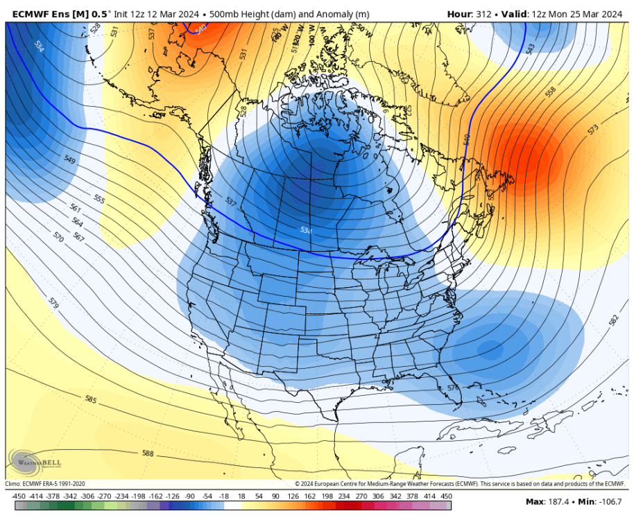
37 minutes ago, TT-SEA said:
EPS mean shows pretty strong signal for cold in central and eastern Canada into the Midwest and NE at 15 days out. I am sure there are a few rogue members to highlight as there always is... but the big picture looks pretty obvious.
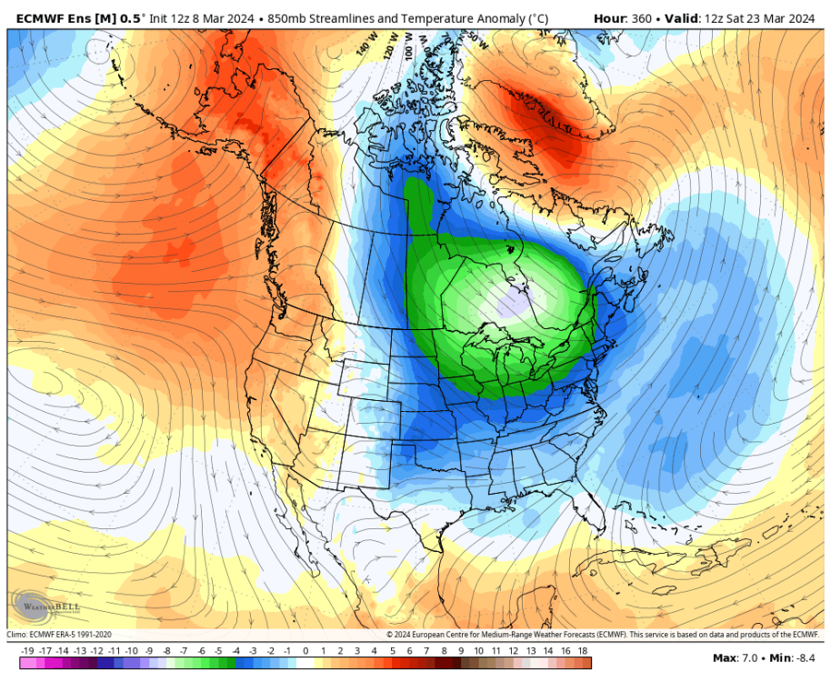
Been a truly neverending torch in that region. Makes sense.
-
2
-
-
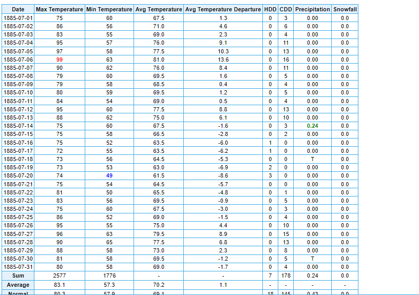
3 minutes ago, TT-SEA said:
95 degrees on the 4th of July!
I bet it must have been a ton of fun in the clothing back then!!!
-
1
-
 1
1
-
-
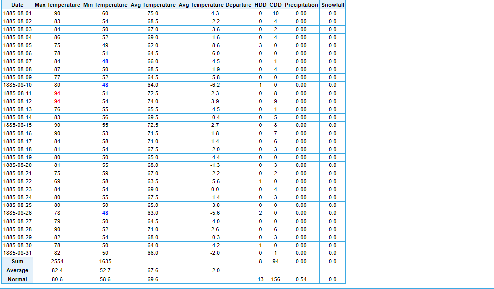
12 minutes ago, TT-SEA said:
Fascinating stuff. I suspect summer of 1885 was not so hot.
A wet/troughy period eventually followed but July was pretty legit actually, and one of the first "hot" summer months in Portland's records. Very comparable to a modern July. Then August was totally dry with plenty of warm afternoons as well, but the UHI influence was clearly a little less back then so the averages were held in check.
-
2
-
-
2 minutes ago, snow_wizard said:
The Seattle city records show 81 on March 11, 1892. The pre 1894 records aren't available online for some reason, but I have them.
Nice! Portland did 76 with that one.
From way back then March-April 1885 has always fascinated me as well. Probably the ridgiest stretch we've seen recorded here in the early spring. And also after a very cold winter. Between March 12 and April 10, Portland only had 0.01" of rain with an average maximum of 67 and what looked like blazing sunshine most of the time. That ridgy stretch lasted until early May and culminated in a 94 degree day on May 5, which gives it pretty good heat cred even by today's standards!
-
5
-
 1
1
-
-
May be tempting fate here, but March is one month where our heat benchmarks are squarely in the past.
Portland did 82 on 3/29/1923 and 83 on 3/28/1930. Interesting thing is that both of those events came on the heels of frigid winters during a very blocky period in our climate history.
And March 1941 was an absolutely coked up Nino torch. Portland's lowest maximum that month was 56, with the monthly average max at a brisk 64 and 8 days of 70+.
-
5
-
 1
1
-
2
-
-
Has anyone checked on the local Maryland or Stampede Pass obits for Phil!?
-
2
-
1
-
-
4 minutes ago, snow_wizard said:
The ball does seem to be in our court right now. I really hope we can hit the big one before that changes. The really impressive thing is we have not had a 1952-53 or a 1957-58 type loser since 2015-16. Even that incredible decade had some utter fails.
Yeah, and the 1957 Nino reset things somewhat after a 9 year stretch where we were constantly in the default trough position in the winter. Even 1952-53 acted very traditionally -PDO and had record January cold in AK that almost spilled down here (think 2019-20).
We're coming up on 9 years of a similar, albeit toned down version of the same thing. But interestingly the big Nino didn't seem to shake things up much. Would be ironic if a giant Nina this year did, but odds are it probably won't.
-
1
-
-
3 hours ago, snow_wizard said:
I guess you could argue we were due for a huge ridge given how easy we got off with the strong Nino this winter. Still time for big changes in the models though.
We really did.
At no point this winter was there ever a strong longwave ridging pattern over the West Coast. The warm patterns out here were from coast to coast SW flow-fests.
The -PDO baseline held firm in that respect, and even Alaska had surprisingly low heights most of the time. And the only serious cold air intrusion that we did see into the lower 48 smacked us pretty squarely.
-
7
-
-
11 hours ago, SnarkyGoblin said:
The truth hurts @SilverFallsAndrew.
Biden benefitted heavily from the near unprecedented voter turnout in 2020. Will he manage that again in 2024 with two such stale and broadly unpopular candidates and the very different pandemic-free circumstances of this year? I have my doubts.
Any significant drop in turnout this go-around will probably serve to favor Trump. Even if there won't be a statistically significant number of people crossing the aisle to vote for Trump, I can in fact picture a much more statistically significant number of 2020 Biden voters simply staying home this time.
-
PDX evidently snuck up to 50 degrees for a few seconds today, while literally every other station in the metro area stayed in the 40s. Not a surprising development, but a devastating one nonetheless.
-
3
-
2
-
-
24 at VUO and 21 at OLM.
Hard freezes!!
-
2
-
-
Seahawks finally cut Jamal Adams, along with Quandre Diggs and Will Dissly.
Nice to see them trimming the fat.
-
2
-
-
48 minutes ago, bainbridgekid said:
It makes a big difference everywhere in the Pacific Northwest. I've always figured that each 100 feet in elevation gain makes about a 15% increase in average snowfall. That means each 500 feet pretty much exactly doubles expected snow in a given year.
The reason it makes such a huge differnece here compared to most of the rest of the country is the temperature is almost always right around freezing for our potential snow events. That's just as true in the Willammete Valley as around Puget Sound. Only exception really is up the Fraser River Valley North of Bellingham and well East of Portland deeper into the Gorge where there is more contintental influence during snow events and elevation often doesn't matter.
Even in the gorge a few hundred feet makes a big difference. White Salmon and the main part of Hood River above the river tend to do quite a bit better than Bingen and the waterfront portion of Hood River. They see a lot more continental influence out that way but there's still a handful of borderline snow events each winter that come around 32-33 degrees.
-
2
-
-
1 hour ago, Deweydog said:

-
1
-
1
-


March 2024 Weather in the PNW
in West of the Rockies
Posted
1964 and more recently 2020 were both cool to cold, albeit with weaker Ninos.
Late March 1964 had a 12z Euro-esque backdoor blast into the northern Rockies. Gave Spokane some very late subfreezing highs on the 23rd- 24th.
1906 way before that was also a Nino to Nina transition with an all-time March airmass.