


Clinton
-
Posts
6520 -
Joined
-
Last visited
-
Days Won
28
Everything posted by Clinton
-
Winter Storm Warning issued: ...WINTER STORM WARNING IN EFFECT FROM MIDNIGHT TONIGHT TO 6 PM CST THURSDAY... * WHAT...Heavy mixed precipitation expected. Total snow accumulations of 4 to 6 inches and ice accumulations of up to one tenth of an inch. Winds gusting as high as 35 mph. * WHERE...Portions of east central and northeast Kansas and central, north central, northwest and west central Missouri. * WHEN...From midnight tonight to 6 PM CST Thursday. * IMPACTS...Travel could be very difficult. Patchy blowing snow could significantly reduce visibility. The hazardous conditions could impact the morning or evening commute.
-
12z CMC 15z RAP is north and a good hit for Tom
-
12z GEFS and EPS are in agreement on the track for the KC area, GEFS is wetter.
-
12z GFS south a hair but pretty steady from 6z.
-
12z NAM great for KC and Detroit
-
It struggles in the the 2-5 day range for sure but it's been good (not perfect) in the 5 to 10 day and inside 24 hrs. I had hoped for better with the upgrade in the mid-range.
-

February 2022 Observations and Discussions
Clinton replied to Grizzcoat's topic in East of the Rockies
I would prefer for it to warm up the second week of March to achieve a good growing season. Hope we get some widespread moisture between now and then esp in the dry areas. Severe weather season will be wild down my way imo. -
12Z HRRR
-
February 2022 Observations and Discussions
Clinton replied to Grizzcoat's topic in East of the Rockies
@TomIf the artic air stays close enough to be taped into. March 3-5th is the time period I'm looking forward to for a large widespread snow. Late next week is interesting also. -
I agree it looks good for all of us in the area. Thunder sleet and thunder snow, sounds like a great storm.
-
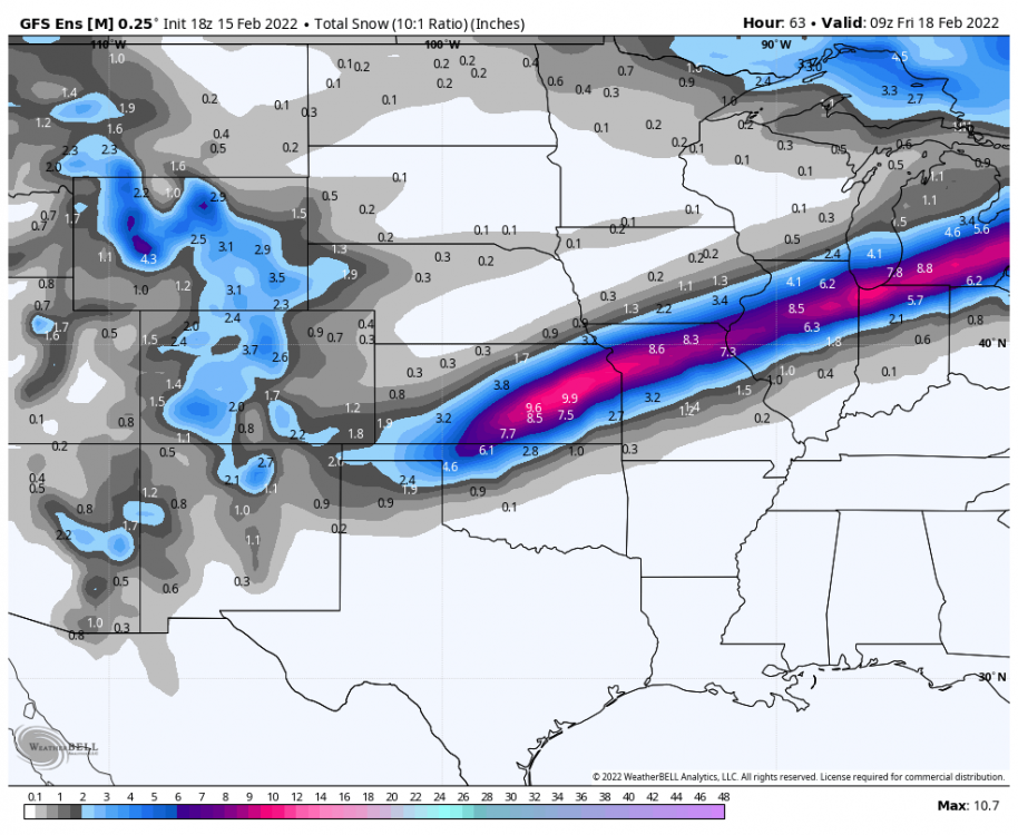
6z Euro still south of the GFS but it did come north some.
-
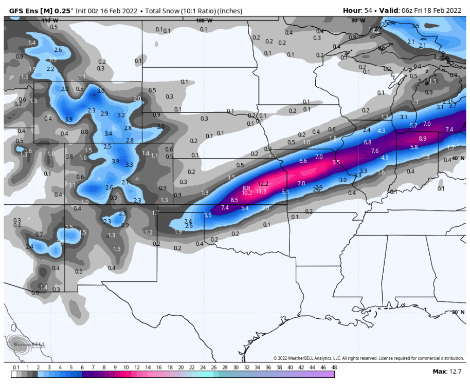
6z GFS
-
Just got keep it there another 24 hrs. Good luck, looks like the modes are all over the place for Chicago.
-
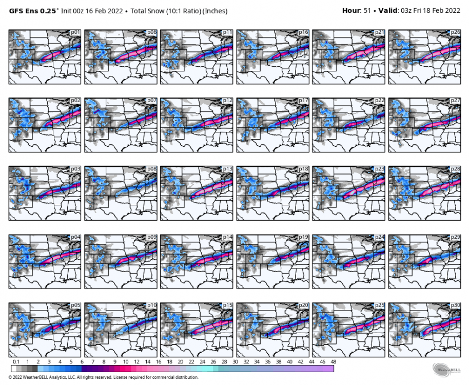
3z SREF Mean @indianajohn @jaster220 @Niko
-
EAX snowfall prediction Discussion: Temperatures this morning are about 10 degrees above the normal high for today`s date, with temperatures primarily in the mid 50s. Gusty southerly winds continue with gusts as high as 40 mph thanks to a strong low level jet that developed overnight. A Wind Advisory remains in effect until noon today, at which point winds should come down a bit (but still remain breezy through the afternoon). Water vapor imagery clearly shows the closed 500 mb low over far southern California as of 4 AM. A trough moving across Canada and the Upper Midwest will send a cold front into NW MO by later this morning. This will create a substantial gradient for high temps today, with highs in the mid 40s near the MO/IA/NE tri state border behind the cold front with highs as warm as the mid to upper 60s across the KC metro and points south and east well into the warm sector. Ascent ahead of the approaching trough will lead to showers developing by this afternoon with even some thunderstorms possible by late afternoon/early evening as we get up to about 500 J/kg of SB CAPE. As the surface low associated with the trough across the Rockies moves west to east across the Texas Panhandle later tonight, the cold front across northwestern MO will get pulled through the region, allowing for cold air to pour in from northwest to southeast. Surface temperatures should cool to below freezing by late evening (likely around midnight ish in KC). However, a warm nose aloft will remain in place, leading to freezing rain initially and then sleet. Some instability looks to still be in place during the sleet phase of the event, so would not be surprised if we have some thundersleet. Ice accretion and sleet accumulations will lead to slick roadways in the overnight period. Changeover to all snow will occur from northwest to southeast through the morning hours of Thursday as thermal profiles become entirely sub freezing as the surface low makes its way across NE Oklahoma and then along the MO/AR border. The period of heaviest snow looks to be between roughly 7 AM and 2 PM on Thursday. During this time northerly wind gusts up to 35 mph will be possible, significantly reducing visibilities and making travel extremely hazardous. Snow should taper off by mid to late Thursday afternoon. While there remains some discrepancies among the models, there is better consensus this morning and we are getting a better idea for where the greatest snowfall totals may be, which as of now appears to be roughly along an axis from the southwestern side of the KC metro (Johnson County KS) to the northeast toward Moberly where 6" to 8" of snow are currently forecast. To the immediate north and south of this axis, 3" to 6" are forecast. Less than 3" are expected across northwestern and far northern MO. A Winter Storm Watch remains in effect from midnight tonight to 6 pm Thursday, although an upgrade to a warning is likely by this afternoon at least for portions of the current watch area.
-
Alot like the last storm. Hopefully it will stop going south.
-
0z GEFS
-
0z GFS great run for all of us in the KC area.
-
This looks so similar to the GHD storm, I don't know if it will turn out the same. That clipper looks good for ya, you look to do well over the next few days.
-
0z NAM stays north
-
0z HRRR
-
18z GEFS with a little south shift.
-
The ICON always there for some humor lol
-
Big jump SE on the 18z ICON
-
Winter Storm Watch ...WINTER STORM WATCH IN EFFECT FROM LATE WEDNESDAY NIGHT THROUGH THURSDAY AFTERNOON... * WHAT...Heavy mixed precipitation possible. Total snow accumulations of 3 to 5 inches and ice accumulations of around one tenth of an inch possible. Winds could gust as high as 35 mph. * WHERE...Portions of east central and northeast Kansas and central, north central, northeast, northwest and west central Missouri. * WHEN...From late Wednesday night through Thursday afternoon. * IMPACTS...Plan on slippery road conditions. Patchy blowing snow could significantly reduce visibility. The hazardous conditions could impact the morning or evening commute.


