Clinton
-
Posts
6521 -
Joined
-
Last visited
-
Days Won
28
Everything posted by Clinton
-
Teleconnections have kinda taken a turn for the worse for the first half of the month. MJO looks stuck in phase 7 for awhile AO and NAO headed +
-
 EAX morning AFD Focus shifts on the potential for minor accumulations of snowfall for Wednesday night into Thursday morning associated with an increase in mid-level frontogenetic forcing in the wake of a strong cold front. There remains considerable model variability with respect to the specifics of snowfall coverage/amounts for our area, but most suggest an event under two inches of accumulation. Confidence is much higher with respect to the bitterly cold temperatures returning Wednesday night into Friday morning as surface high pressure settles into the region. Overnight lows will be in the single digits to single digits below zero both nights. A much warmer day will return by Saturday as upper ridging builds into the region, with highs returning to above normal levels.
 -
0z CMC a little less juiced up north and across the lake region than the GFS. More robust and strengthens the second storm as it moves across the plains into the Ohio Valley.
-
0z GFS is weaker than the other models with the southern storm.
-
Here's todays 12z Euro and CMC for both systems. The 18z GFS is beginning to find the second storm.
-
Coldest morning of the season so far. I had a low of 5 this morning on my up to 17 this afternoon under sunny skies.
-
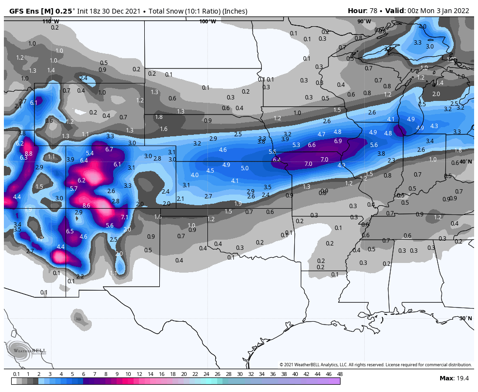
KC area peeps are going to be very gun shy of the models, can't blame us for that. But these smaller snowfall events do verify more often than the ones showing KC getting a foot of snow. Lets see if we can break the ice and land a few inches of snow as we are within the 120 hr mark. 6z GFS was dry this morning as it lacked moisture, 6z ICON is in the same camp as the Euro and not as over juiced as the CMC.
-
Going to finish up with a 1/2 of snow and sleet mix, very disappointing but it does look and feel like Winter for the first time this season.
-
KC finished December exactly 10.0 degrees above normal and was the 3rd warmest on the 134-year record! KC picked up only 0.50" of precip for the 23rd driest Dec. on record. Dec 2021 was 1 of only 2 (2004) in 134-years to not receive even a trace of snow!
-
The MJO looks to do a brief backtrack to phase 7 then move back into phase 8. There is a growing number of more amplified members.
-
It's currently 17 degrees with light snow falling, 43 degrees colder than this time yesterday. GFS and Euro bring down another shot of artic air later next week and a posable weenie band of snow in my area Thursday.
-
Precip here has changed to sleet which is slightly less sucky than frz rain. If I can get enough snow to get the ground white later I'll call it a win.
-
@Tom12z HRRR has the lake really pumping up your totals! It's a icy mess here this morning so good luck and hope it goes bigly for you. Very jealous of Ottuma this morning, he's going to have a great day if the models hold true.
-
Local mets this morning saying 2-4 for your area! Right now things are pretty icy, frz rain has been falling since 3am . Your precip should change to snow around noon.
-
3z RAP @mlgamer @Jayhawker85Rap and other models look good for you guys tonight. Good luck, I hoping for an inch or two down here.
-
@OttumwaSnomowbusiness is going to be busy!
-
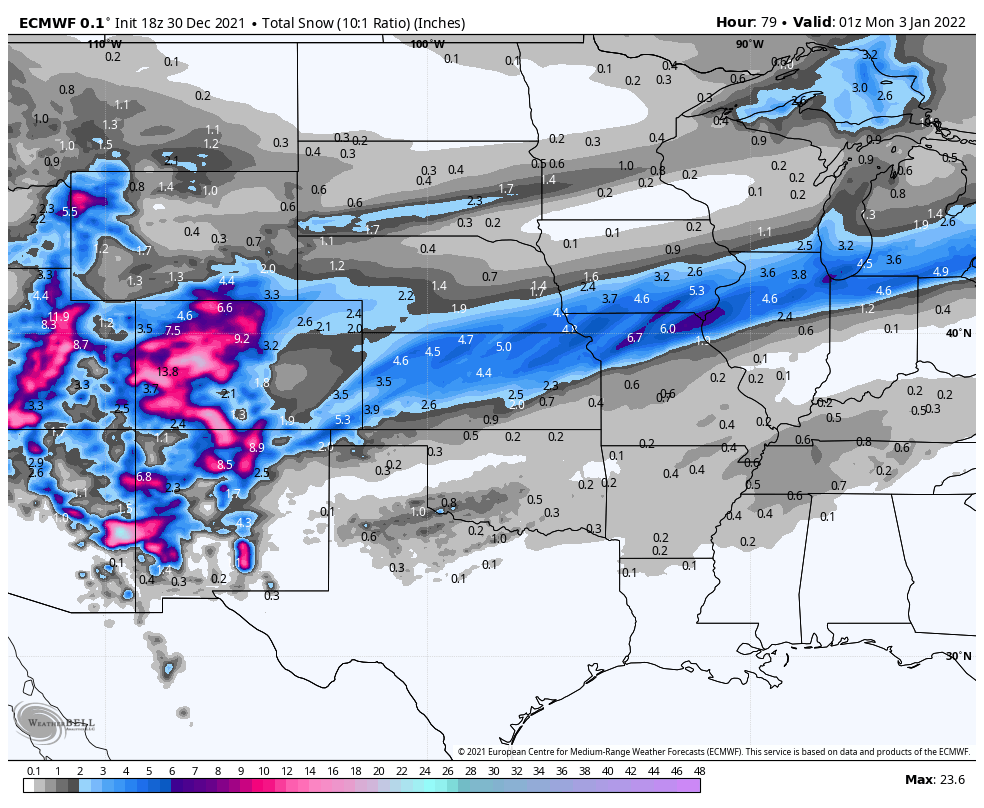
12z Euro going to make for a tough forecast in KC.
-
Things could get very icy my way. For me it looks like that is how it's going to be, not much time for things to change. Good luck!
-
6z Euro @mlgamerhow close are you to that heavy band?
-
It needs to try harder lol. Still mostly a ice fest for me.
-
0z NAM coming in colder, has snow for KC instead of sleet
-
18z Euro is improving
-
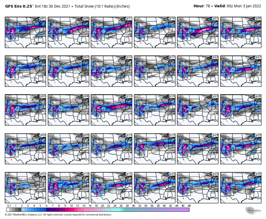
Here's the 18z GEFS ensembles

-
That's like 3 years worth around here lol.
-
12z GEFS mean is maybe a little wetter. Ensembles are beginning to lock in.