

ShawniganLake
-
Posts
15521 -
Joined
-
Last visited
-
Days Won
25
Everything posted by ShawniganLake
-

December 2014 Observations for the Pacific Northwest
ShawniganLake replied to stuffradio's topic in West of the Rockies
Yesterdays Euro EPO forecast And PNA forecast. Seems strange that the Euro has the ridge moving overhead with the PNA ensemble being so negative, for early January.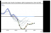
-
December 2014 Observations for the Pacific Northwest
ShawniganLake replied to stuffradio's topic in West of the Rockies
I suppose weatherphil is lounged back in his recliner, smoking a large cigar, has a giant smile on his face, and is flipping back and forth between this forum and the 12z GFS model loop. -
December 2014 Observations for the Pacific Northwest
ShawniganLake replied to stuffradio's topic in West of the Rockies
looks fine for BC to me -
December 2014 Observations for the Pacific Northwest
ShawniganLake replied to stuffradio's topic in West of the Rockies
http://vortex.accuweather.com/adc2004/pub/includes/columns/community/2014/590x382_12261533_hisnow1225a.jpg -
December 2014 Observations for the Pacific Northwest
ShawniganLake replied to stuffradio's topic in West of the Rockies
39/31 here today. Hasn't been as torchy over here as some other places in the region have been this month. 9 freezes so far. -
December 2014 Observations for the Pacific Northwest
ShawniganLake replied to stuffradio's topic in West of the Rockies
So why all the sadness this afternoon? -
December 2014 Observations for the Pacific Northwest
ShawniganLake replied to stuffradio's topic in West of the Rockies
Haha. This place is funny. 3 hours ago the second blast was a near write off. Now all is right in the world. What seems likely at this point is some type of -EPO block and possibly some SE ridging of some amplitude. Seems like a good pattern for something good to evolve out of. And honestly it doesn't really feel like any major players have changed in the last few hours. -
December 2014 Observations for the Pacific Northwest
ShawniganLake replied to stuffradio's topic in West of the Rockies
I am not much for debating things, but it doesn't really seem like the modelling as a whole has shifted that much when looking at the long range, possible reload situation. -
December 2014 Observations for the Pacific Northwest
ShawniganLake replied to stuffradio's topic in West of the Rockies
Some models have been flirting with the idea of at least enough enhancement for some flurries later Sunday and Monday. The risk looks fairly minor at this point. -
December 2014 Observations for the Pacific Northwest
ShawniganLake replied to stuffradio's topic in West of the Rockies
I'm thinking you still think it is coming? -
December 2014 Observations for the Pacific Northwest
ShawniganLake replied to stuffradio's topic in West of the Rockies
Totally agree, I think that's all we can ever take away from the models when we are looking at the 6-14 day range. -
December 2014 Observations for the Pacific Northwest
ShawniganLake replied to stuffradio's topic in West of the Rockies
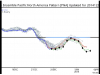
Not great, marginally better. http://www.wetterzentrale.de/pics/MT8_Vancouver_Kanada_ens.png http://www.wetterzentrale.de/pics/MT8_Portland_Oregon_USA_ens.png -
December 2014 Observations for the Pacific Northwest
ShawniganLake replied to stuffradio's topic in West of the Rockies
I like our chances of seeing something white. -
December 2014 Observations for the Pacific Northwest
ShawniganLake replied to stuffradio's topic in West of the Rockies
So why do you always feel the need to tell Jim that his conclusions are wrong? -
December 2014 Observations for the Pacific Northwest
ShawniganLake replied to stuffradio's topic in West of the Rockies
Seriously........................Are you making this up? -
December 2014 Observations for the Pacific Northwest
ShawniganLake replied to stuffradio's topic in West of the Rockies
nevermind...........it isn't. -
December 2014 Observations for the Pacific Northwest
ShawniganLake replied to stuffradio's topic in West of the Rockies
It will probably be good at day 10.......................again -
December 2014 Observations for the Pacific Northwest
ShawniganLake replied to stuffradio's topic in West of the Rockies
I have seen events up here where my area at 500ft receives 6-10" more than places near sea level 5-6miles away. -
December 2014 Observations for the Pacific Northwest
ShawniganLake replied to stuffradio's topic in West of the Rockies
Better for Washington than Oregon. Would be quite snowy in about a weeks time -
December 2014 Observations for the Pacific Northwest
ShawniganLake replied to stuffradio's topic in West of the Rockies
Looks like another shortwave digging south after day 9 as well. -
December 2014 Observations for the Pacific Northwest
ShawniganLake replied to stuffradio's topic in West of the Rockies
I agree with this assessment. -
December 2014 Observations for the Pacific Northwest
ShawniganLake replied to stuffradio's topic in West of the Rockies
Yea I guess. Still managed 30" here last winter, despite the 2 dry arctic events. Could have been an incredible winter with a little snow going into those two events. But yea, some other areas have been less lucky up here. Victoria is due for something respectable. -
December 2014 Observations for the Pacific Northwest
ShawniganLake replied to stuffradio's topic in West of the Rockies
Backdoor cold pushes gets their blood pumping. -
December 2014 Observations for the Pacific Northwest
ShawniganLake replied to stuffradio's topic in West of the Rockies
My area averages 30+ inches per year, so maybe my standards are a little higher than say SEA or PDX. An average winter season there would be a failure here in the snow department. Shift things west 100 miles, throw some arctic air out over the ocean around northern Vancouver Island, and you might peak my interest a little more. -
December 2014 Observations for the Pacific Northwest
ShawniganLake replied to stuffradio's topic in West of the Rockies
The first brush with cold air isn't looking like a big deal to me at this point. Best case scenario would be a repeat of the late November event. I would be happy if it even worked out that great. Most likely will be dry and chilly. Looks like the colder temps come from a backdoor like push from the east, which generally struggles to pump the Fraser river outflow, probably much better results for Gorge effected areas. The few model runs that are starting to toy with the idea of a surface low forming could make it interesting. My hopes are more focussed on the potential second shot, hoping for some better over water trajectory with the arctic air with that one. But that's a big if right now, but I do like the trends for early January


