mlgamer
-
Posts
802 -
Joined
-
Last visited
Everything posted by mlgamer
-
January 2024 Observations and Discussion
mlgamer replied to Minny_Weather's topic in East of the Rockies
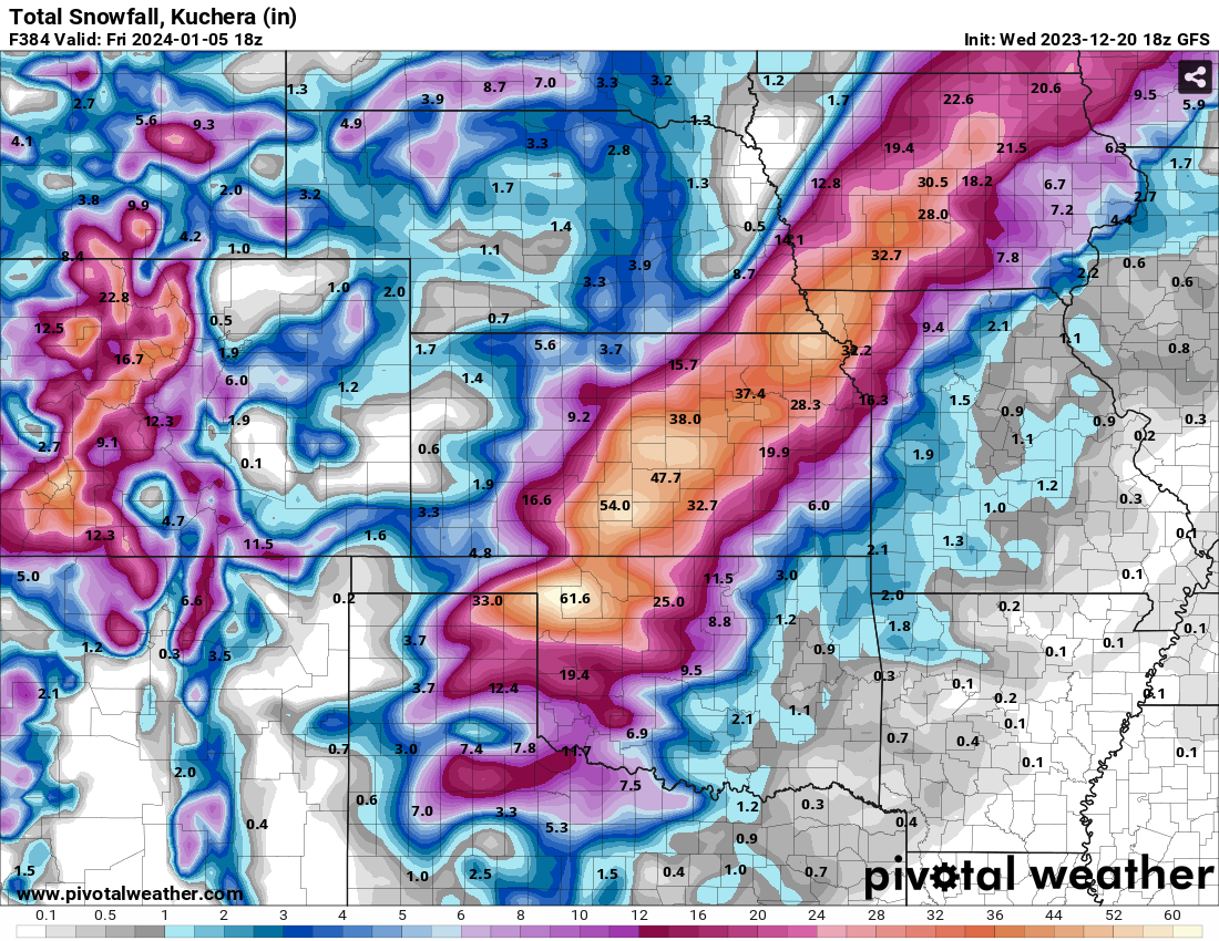
I have Jan 15-16 and Jan 20-22 as dates to watch in my earlier notes so I'd agree. On another note....we've all been talking about Jan 7-10 for awhile. Here is a tidbit from today's (12/29) Topeka NWS afternoon AFD: "The strongest signal for precipitation currently extends just beyond the end of the forecast period, in the Jan 8-10th period." -
January 2024 Observations and Discussion
mlgamer replied to Minny_Weather's topic in East of the Rockies
Oh boy...GFS is already trolling me on the storm around Jan 7-10...00z misses me to the northwest and 06z misses me to the southeast with the heavy snow track. That's not playing nice...lol -
DECEMBER 2023 Observations and Discussion
mlgamer replied to Grizzcoat's topic in East of the Rockies
Even with high temps in the 30s the past three days, Topeka is still running at +7.0(F) temp anomaly for December. I'm sure that will be close to the top of the list for warmest Decembers here. Precip is above normal as well...2.92" (+1.58") along with 1.3" of snow. -
January 2024 Observations and Discussion
mlgamer replied to Minny_Weather's topic in East of the Rockies
Here we go @Clinton. Midnight January 10th right on schedule. GFS knows something...lol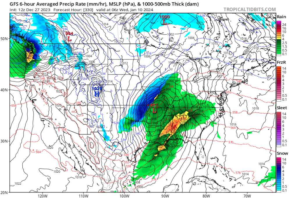
-
I would have picked up several inches of snow today in moderate to heavy snow but temps in the mid 30s kept melting it. Still, it was very picturesque and perfect for Christmas time!
-
DECEMBER 2023 Observations and Discussion
mlgamer replied to Grizzcoat's topic in East of the Rockies
December temp anomaly for Topeka is now sitting at a blazing +5.4F with an avg temp of 40.6F for the month. Not very winter-like to state the obvious. -
Back in the glory years we'd often get thunderstorms a day or two before a big snowstorm. Don't see much of that here anymore and I think a big reason is we don't get the clashes of very warm moist air with very cold air masses here like we used to.
-
DECEMBER 2023 Observations and Discussion
mlgamer replied to Grizzcoat's topic in East of the Rockies
This would actually go in a January thread...and view with caution...NSFW...
-
DECEMBER 2023 Observations and Discussion
mlgamer replied to Grizzcoat's topic in East of the Rockies
Yeah, it's pretty ridiculous even though getting the needed moisture is good. And whoever thought we could use the thunderstorm emoji ==> in mid-late December? lol
-
DECEMBER 2023 Observations and Discussion
mlgamer replied to Grizzcoat's topic in East of the Rockies
Sing it with me..."I'm dreaming of a noisy Christmas..." From the afternoon TOP disco: "After potentially some dry time Friday night into early Saturday, a pair of closed upper lows converge on the Rockies and Plains early next week with the southern low becoming an open wave and being absorbed by the northern stream wave. Variability remains high in how these systems evolve and interact, but there remains a good signal for a period of wet weather, and perhaps some thunder, this weekend into the Christmas holiday. With the warm air in place, chances for wintry precipitation remain very low (10%) through Monday." -
DECEMBER 2023 Observations and Discussion
mlgamer replied to Grizzcoat's topic in East of the Rockies
Euro gives TOP-KC-STJ and maybe @Clinton area a big snowfall starting Christmas Day into the following day! Yeah, we'll see. lol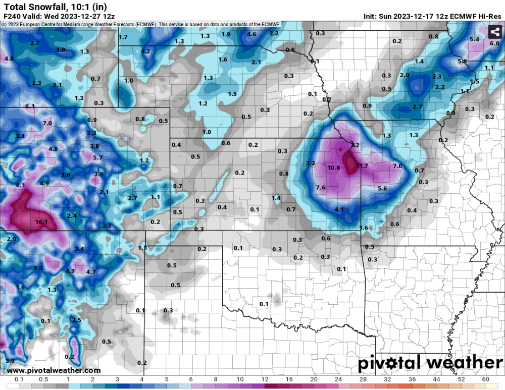
-
DECEMBER 2023 Observations and Discussion
mlgamer replied to Grizzcoat's topic in East of the Rockies
Well, I was expecting this pattern to be pretty dry for me the next three weeks but there were subtle hints that it could be more productive in future cycles and that may be the case as the models are pretty bullish in bringing precip here in the coming days. Of course, no cold air so rain it is. It is what it is. -
DECEMBER 2023 Observations and Discussion
mlgamer replied to Grizzcoat's topic in East of the Rockies
MBY ended up with 1.12" total rain from this system. Topeka December Fun Facts... Topeka officially set a record rainfall amount yesterday (Dec 15) with 0.86" (old record 0.79" 1940). The temp anomaly for December 1-15 is +4.9F. Dec 2 the high was 36F. All other highs have been in the 40s, 50s, or 60s. -
DECEMBER 2023 Observations and Discussion
mlgamer replied to Grizzcoat's topic in East of the Rockies
I mentioned in the autumn and winter discussion thread that Topeka set it's all time record low December 23, 1989 at -26F. December 1989 was a wild ride for lots of folks! -
DECEMBER 2023 Observations and Discussion
mlgamer replied to Grizzcoat's topic in East of the Rockies
Hey Clinton, yeah no cold air around when you need it...lol. I'll get a storm total tomorrow, but I have likely picked up around 1" or more of rain. I've mentioned a couple of times that I'm looking at Jan 9/10 as my next chance of significant precip and if Gary thinks it may be snow that's even better. I see more precip chances during January which could be snowy if we can keep some cold air around. Feeling more optimistic than pessimistic about it for once...lol. -
DECEMBER 2023 Observations and Discussion
mlgamer replied to Grizzcoat's topic in East of the Rockies
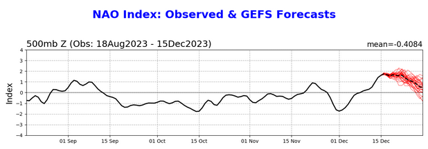
Not surprisingly at all, the AO and NAO are now both solidly positive after being solidly negative at the first of the month, even though they are both forecast to trend downwards. In fact, looks like they are (or will be) at their highest points since sometime before mid-August. It's always something...lol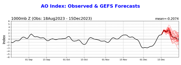
-
DECEMBER 2023 Observations and Discussion
mlgamer replied to Grizzcoat's topic in East of the Rockies
Right on schedule we have a potent little system moving through today. The circulation is evident on the radar loop below. Of course, no cold air so this is a rainer for MBY, maybe up to 1" and I have about 0.5" already. After this period of rain ended in October we had a 21 day dry spell into mid-November. Because of this, I am skeptical of any *significant* precip until around Jan 9/10, even though the models have been showing systems close by at times around Christmas and New Year's Day. As always, just have to wait and see what comes along next.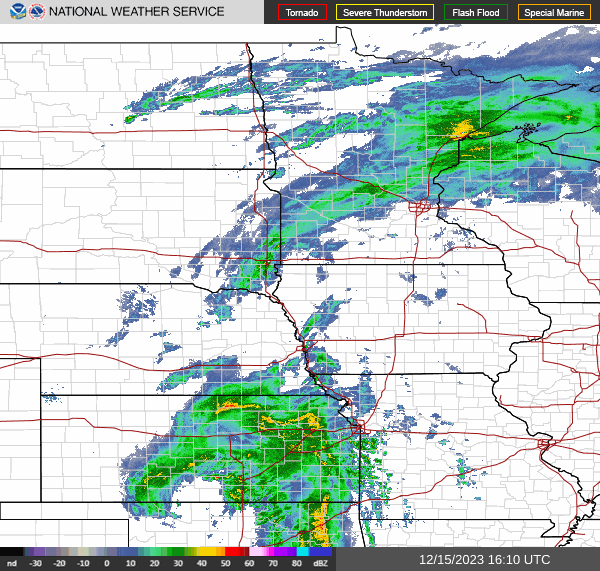
-
DECEMBER 2023 Observations and Discussion
mlgamer replied to Grizzcoat's topic in East of the Rockies
Yep! Model over-hype and the LRC is why I'm thinking Jan 9/10 may be my next chance of anything above flurries or sprinkles! But that eastern storm looks like a doozy so at least something interesting is going on...lol -
I agree. Also, if I were to think of a similar "harsh" December for me it would be 1983 and 1989. December 1983 was very cold and snowy start to finish. December 1989 was very interesting. It was pretty mild on the front and backend with a bitter cold snap in the middle of the month Dec 11-24. Topeka set it's all time record low of -26 on December 23 and had a high of 46 on Christmas Day. The temp had climbed 72 degrees in basically two days.
-
China appears to be enduring a harsh December (all part of that recent Siberian cold blob) which reminded me of their severe winter of 2008. It seems we have nothing quite as harsh as this reads in the USA anymore. This is pretty interesting stuff... https://www.reuters.com/world/china/china-braces-blistering-cold-this-week-2023-12-12/ Snow, blizzards and plunging temperatures swept northern China in what could be one of its most severe cold snaps in December, spurring authorities in the capital to halt train services, shut schools and tell people to stay home. A mass of cold air drifted into Beijing from the west, the second cold wave this week. City officials have issued the second-highest alert for blizzards through Thursday, the only such warning yet in the country... ...This week's cold snap, compared with the autumn-like conditions of a week ago, reflects recent sharp temperature swings. October was one of Beijing's warmest in decades, in a year of weather extremes... ...Temperatures could drop more than 14 C, across swathes of northern, northwestern and southern China, along with parts of Inner Mongolia, Guizhou province and even regions south of the Yangtze River, weather officials have said. Issuing its first alert since 2013 against freezing temperatures, the National Meteorological Centre (NMC) urged local governments to take precautions, along with measures to protect tropical crops and aquatic produce. It has forecast wide rain and snowfall in central and eastern regions until Friday, with as much as 30 mm (1.2 inches) of precipitation in snowstorms in parts of Shaanxi, Henan and Shandong provinces. The cumulative snowfall could be the highest in the corresponding period in a decade, it added. Many rivers have already frozen over in the vast northeastern province of Heilongjiang bordering Russia. https://en.wikipedia.org/wiki/2008_Chinese_winter_storms The 2008 Chinese winter storms were a series of winter storm events that affected large portions of southern and central China, where it does not usually snow severely or extensively, starting from 25 January 2008, until 6 February 2008. The systems affected most of the area with heavy snows, ice, and cold temperatures causing extensive damage and transportation disruption for several thousand travelers. It became China's worst winter weather in half a century. According to some media sources, the storms were directly responsible for at least 129 deaths...(more at link)
-
DECEMBER 2023 Observations and Discussion
mlgamer replied to Grizzcoat's topic in East of the Rockies
Seeing that low spin up in the gulf on the models made me think of the 1993 superstorm as well. Interestingly, Topeka had set it's daily snowfall record of 15.2" two months earlier on January 9, 1993 with a storm total of 17"-19" around the area. Winter in early 1993 had some exciting weather for sure! -
DECEMBER 2023 Observations and Discussion
mlgamer replied to Grizzcoat's topic in East of the Rockies
For MBY... after my rain chances the next couple of days, I don't see any *significant* precip chances here till around Jan 9/10 based on the observed pattern. I'm not buying any big storms in my area through the end of the year into early January. As usual, would be glad to be wrong. -
DECEMBER 2023 Observations and Discussion
mlgamer replied to Grizzcoat's topic in East of the Rockies
Hey, good luck on your move! It never hurts to do something new or different! I think the winters of the 70s and 80s spoiled me and I miss those years of cold and snow especially around the holidays. Check out this fun fact...compared Topeka January 1979 to January 2023. It's only a couple of data points but does illustrate how things have changed. Jan 1979: avg hi 22, avg low 2 Jan 2023: avg hi 44.4, avg low 24.2 (lowest high was 23 for the month..higher than the average for Jan 1979) -
DECEMBER 2023 Observations and Discussion
mlgamer replied to Grizzcoat's topic in East of the Rockies
Yeah we had quite a few damp days in row then. I don't have the numbers handy, but I think we had measurable rain like 4 out 5 days. That was really good considering how dry the summer and fall had been. -
DECEMBER 2023 Observations and Discussion
mlgamer replied to Grizzcoat's topic in East of the Rockies
The weekend system is a big nothing burger here (as it was on Oct 18/19) so I'm still looking at Dec 14-16 for my next weather maker. All of the globals show a system in one form or another affecting the central states around then. This system produced very heavy rains just south and east of me Oct 24/25. It will be interesting to follow model trends in the coming days.