The Snowman
-
Posts
422 -
Joined
-
Last visited
-
Days Won
1
Everything posted by The Snowman
-
December 2022 Observations and Discussion
The Snowman replied to Iceresistance's topic in East of the Rockies
Using the latest ECMWF ENS 500mb anomaly Hovmoller as a guide, it's likely we see a shift in the NH pattern after 12/15 or so, as the Pacific jet stream changes from its current significantly retracted phase to a modestly more extended state (i.e. the Pac. jet extends into the same longitudes as the central Aleutian Islands rather than its current position in longitudes west of the islands). This means a change in the northeast Pacific basin from ridging around the Aleutian Islands - provoking the negative PNA pattern we're seeing thru mid-month - to ridging in the Gulf of Alaska and western U.S. This should create a blend of a -EPO/+PNA pattern, though in both cases the result is a delivery of cold Canadian air into the Central U.S. Whereas the current -PNA pattern favors Central U.S. storm tracks to be shifted north, the post-12/15 pattern likely favors a reversal whereby cold Canadian air will have a much easier time pressing southwards and suppressing storm tracks. It's worth watching to see if models struggle to latch on to this change in regime and potentially take on a northern storm track bias for a bit, simply because this otherwise-subtle change in the Pacific has significant downstream impacts in the CONUS. Unless the MJO returns to a coherent state at some point before the new year (looking unlikely), and unless global angular momentum jumps back towards positive territory (even more unlikely, especially as we maintain Equatorial t-storm activity in the western Indian Ocean thru early-January), the Central is likely to end the year on a cold note. Don't be surprised if the first half of Dec. favors snow in the northern Plains / Upper MW while the back half shifts the snow focus to the Central Plains / broad I-80 corridor.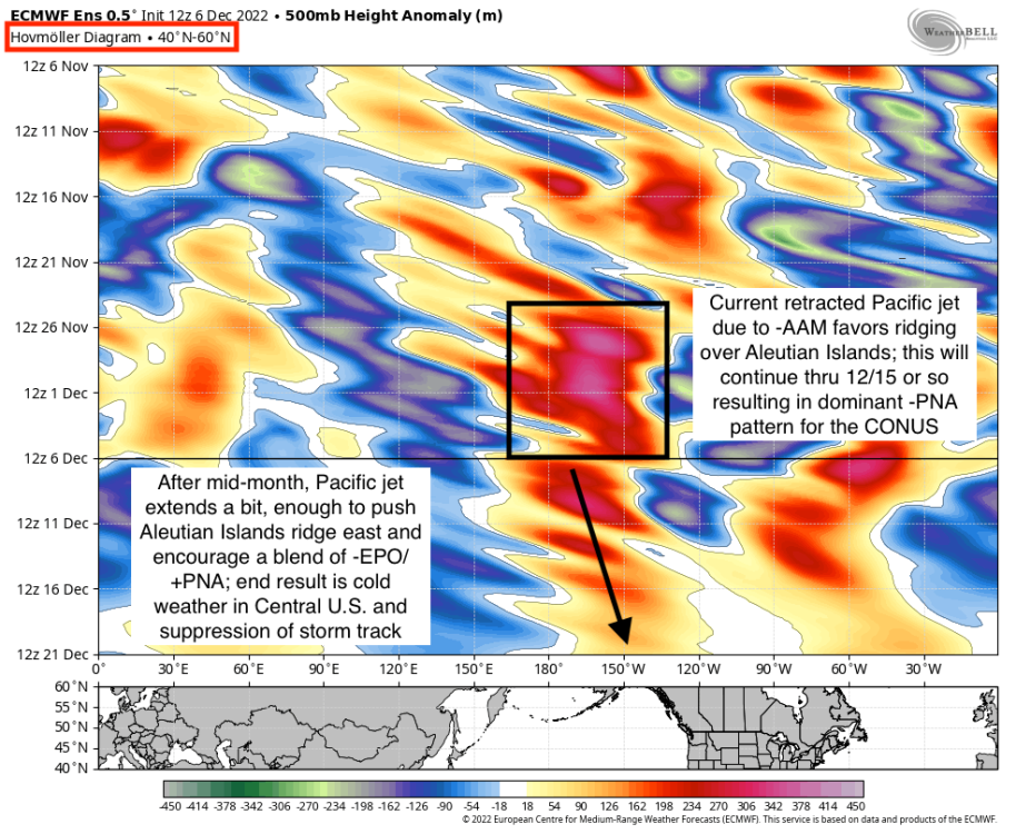
-
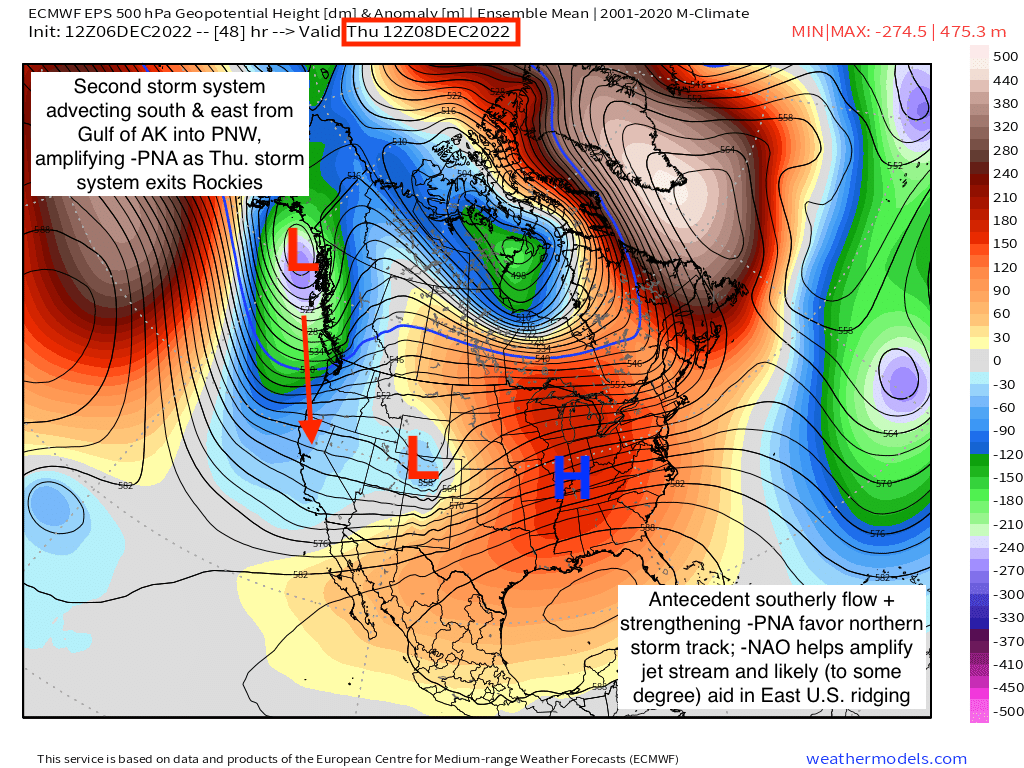
I'm making it sort of a personal goal to actually dissect the reasons for local storm whiffs this winter, the hope being that learning from mistakes helps sniff out what will actually happen instead of living & dying by individual model runs. In this situation it seems like the synoptic pattern doesn't favor anything other than northward storm tracks. Featuring most prominently in that reasoning is how our storm system next week will be actively digging south & east from the Gulf of Alaska into the West Coast, creating not only a -PNA set-up but an intensifying -PNA set-up as that trough moves in. It's worth mentioning the 'intensifying' part because it supports intensifying ridging downstream in response to the -PNA, making it an uphill battle for southerly storm tracks to pan out. Likely adding some degree of influence is the ongoing -NAO, which continues to keep the North American jet stream nice and meridional on the whole. Instead of supporting cold chances, though, it amplifies the -PNA pattern. This isn't a big surprise - a regime upstream of any given location will almost always have a more direct impact on that location's pattern than a regime downstream, referring here to the PNA and NAO respectively - but does help to amplify the upper-level flow as a whole. Unfortunately for us folks around I-80, this means a preference for a deeper -PNA and, consequentially, a stronger East U.S. ridge which pumps storm tracks further north. The event hasn't happened yet, so it's not really a postmortem, but clearly the synoptic pattern favors the storm taking that northward track the GFS clung to initially.

-
December 2022 Observations and Discussion
The Snowman replied to Iceresistance's topic in East of the Rockies
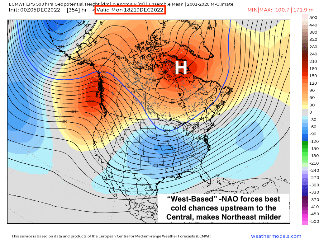
It's a shifting culprit; in the short-term it's a function of a Rex Block type of pattern off the West Coast that encourages zonal flow downstream, acting to keep the tropospheric polar vortex from pushing too far south. An emergent -PNA (which forms the southern component of the Rex Block type feature) doesn't help matters either. Moving towards mid-month, the -NAO ridge retrogrades a bit west, paradoxically allowing the Northeast to be milder than the rest of the country and displacing the best chances for colder weather further to the west, in the heart of the Central. A modest eastward extension of the Pacific jet will help turn the PNA positive, which should present the Plains/MW with the best opportunity for cold weather in the back half of the month. Annotated 500mb anomaly images for hour 0 and Hour 354 from the 0z Euro ENS attached to show each component.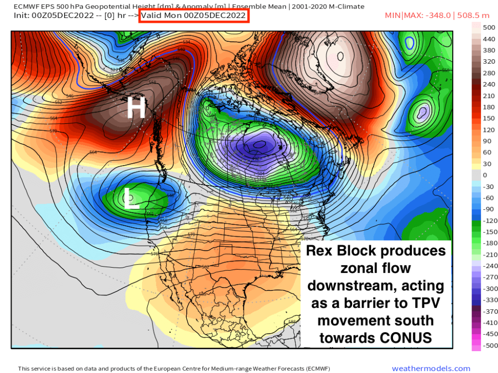

-
December 2022 Observations and Discussion
The Snowman replied to Iceresistance's topic in East of the Rockies
First time of the season I'm up for the 0z Euro for a snowstorm threat, now will it be a run that inspires crippling depression or euphoric joy? -
December 2022 Observations and Discussion
The Snowman replied to Iceresistance's topic in East of the Rockies
00z Canadian with a nice little ice storm in the Omaha area.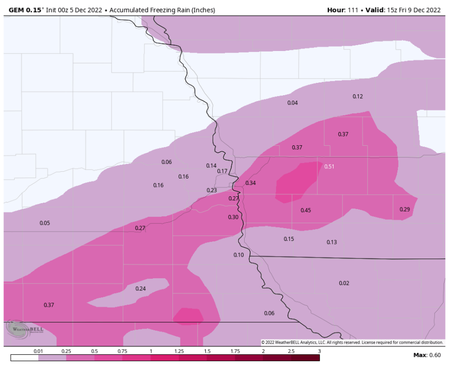
-
December 2022 Observations and Discussion
The Snowman replied to Iceresistance's topic in East of the Rockies
Alright alright I'll bite. Wondering if models are starting to slowly but surely hone in on a snowier solution for the NE/IA I-80 stretch because we're also slowly but surely getting more and more energy onshore. Can see some of the mass of vorticity currently on land, good portion of it still offshore.
-
Clearly I need a gut check. Not the best sign when I'm forced to cling to the NAM & hi-res peanut gallery for hopes of >4" of snow, but gosh darn it that's what I'll do!
-
Note for us Nebraska folks at least, this snow should be falling in temps cold enough to render 10:1 ratio maps inaccurate. Raw Kuchera totals might not be valid to the decimal, but IMO are more trustworthy for this event.
-
00z GFS will tick north for Nebraska.
-
I don't know, I'm feeling unusually good about this one for Omaha. Gut feeling, nothing based on data or whatnot. We will see.
-
2/1 - 2/3 MW/Lower Lakes Major Winter Storm (GHD-3)
The Snowman replied to Tom's topic in East of the Rockies
I would pay an irrational amount of money to get that to verify... -
2/1 - 2/3 MW/Lower Lakes Major Winter Storm (GHD-3)
The Snowman replied to Tom's topic in East of the Rockies
Well, if I'm up this late, might as well be up for the Euro... -
2/1 - 2/3 MW/Lower Lakes Major Winter Storm (GHD-3)
The Snowman replied to Tom's topic in East of the Rockies
0z GFS should start running any moment now, place your bets... -
2/1 - 2/3 MW/Lower Lakes Major Winter Storm (GHD-3)
The Snowman replied to Tom's topic in East of the Rockies
Northern Illinois looking like the place to be on the 0z NAM. Let's see what the GFS shows. -
2/1 - 2/3 MW/Lower Lakes Major Winter Storm (GHD-3)
The Snowman replied to Tom's topic in East of the Rockies
18z ECMWF running, get your bets in now! -
2/1 - 2/3 MW/Lower Lakes Major Winter Storm (GHD-3)
The Snowman replied to Tom's topic in East of the Rockies
Well, technically not in the game... may or may not have booked a flight home for this thing... Cheers to heavy snows & northward shifts! -
2/1 - 2/3 MW/Lower Lakes Major Winter Storm (GHD-3)
The Snowman replied to Tom's topic in East of the Rockies
Regional QPF thru Thursday night is attached. For posterity.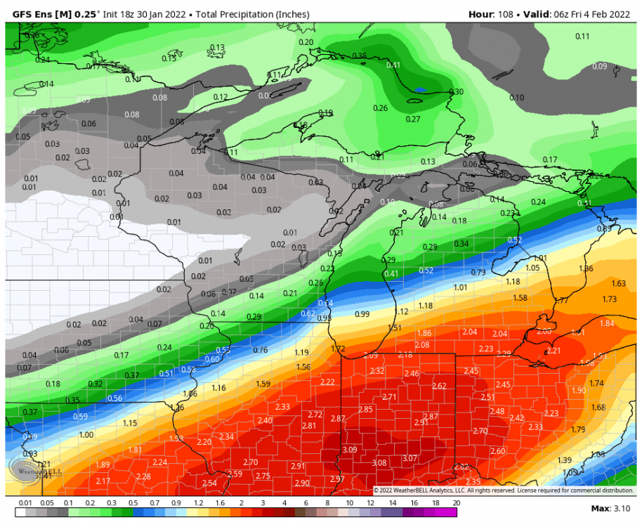
-
2/1 - 2/3 MW/Lower Lakes Major Winter Storm (GHD-3)
The Snowman replied to Tom's topic in East of the Rockies
Might be a long time before we see an ensemble signal like this again, with such a comparatively short timeframe before the actual event (whether it ends up being correct or not is a different question). -
2/1 - 2/3 MW/Lower Lakes Major Winter Storm (GHD-3)
The Snowman replied to Tom's topic in East of the Rockies
18z GFS ENS absolutely shellacks the region, including a northward tick. Downtown Chicago sees almost 1.7" QPF (assuming ratios somewhere around 15:1 that would imply 25". -
2/1 - 2/3 MW/Lower Lakes Major Winter Storm (GHD-3)
The Snowman replied to Tom's topic in East of the Rockies
GFS ENS appear to be following with a tick northwards thru Hour 66 -
2/1 - 2/3 MW/Lower Lakes Major Winter Storm (GHD-3)
The Snowman replied to Tom's topic in East of the Rockies
Hoo boy... QPF through Thursday PM from the 18z GFS shown. For the Northeast IL folks, I know there's some inkling of precip mixing concerns early on with the overrunning precip shield; from what I can tell, though, the *heavy* majority of precip for this entire event will be falling in an airmass supportive of 15:1 - 17:1 ratios (per Pivotal's Kuchera Ratio charts). Taking that verbatim - a dangerous game to play, of course - implies downtown Chicago would be looking at 22" - 25" from this event.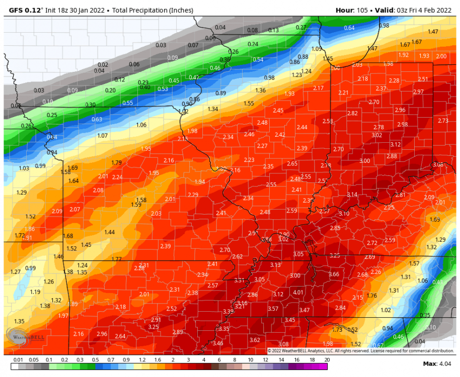
-
2/1 - 2/3 MW/Lower Lakes Major Winter Storm (GHD-3)
The Snowman replied to Tom's topic in East of the Rockies
18z GFS northbound -
2/1 - 2/3 MW/Lower Lakes Major Winter Storm (GHD-3)
The Snowman replied to Tom's topic in East of the Rockies
As it stands now, feeling very good about >4" in Chicagoland (save for those in Lake County suburbs and points west, though LES may save the day there) and liking what I'm seeing in today's trends for amounts exceeding 6". Any additional ticks northwards (whether in the 18z or tonight's 00z suite) would probably be enough to get double digits, assuming the usual caveats (moisture doesn't end up worse than modeled, etc.) -
2/1 - 2/3 MW/Lower Lakes Major Winter Storm (GHD-3)
The Snowman replied to Tom's topic in East of the Rockies
Sorry, was looking at the control line instead. Mean QPF from the *average* is closer to 1.2" (let's call it 1.15") which would equate somewhere around 16-20". Goodness.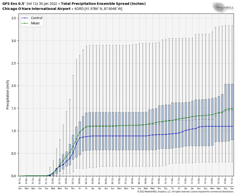
-
2/1 - 2/3 MW/Lower Lakes Major Winter Storm (GHD-3)
The Snowman replied to Tom's topic in East of the Rockies
Since Omaha's out of the running, I'll turn my eyes to my Chicago roots... 12z GFS ENS mean QPF is somewhere between 0.80" and 0.90" eyeballing it; 12z GFS Kuchera Ratios per Pivotal were somewhere around 14:1 - 17:1 for most of the event, so not a wild guess to assume this QPF translates to 11-15".