

jaster220
-
Posts
12213 -
Joined
-
Last visited
-
Days Won
59
Posts posted by jaster220
-
-
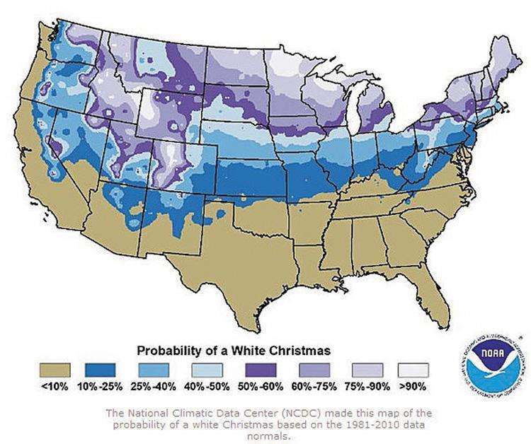
6 hours ago, Minny_Weather said:
Digging a bit deeper into this, the following locations in MN have a historic 100% probability of >1" OTG at Christmas on record. Some of these do surprise me given their locations in the Plainsy far NW part of the state.
*Locations with a * have 40+ years of record
- Agassiz Wildlife Refuge
- Babbitt
- Big Falls
- Cass Lake
- Cloquet*
- Cook
- Cotton
- Crane Lake
- Gunflint Lake
- Hoyt Lakes
- Isabella (also 100% of 5"+)
- Island Lake
- Park Rapids*
- Pigeon River Bridge
- Pine River Dam
- Remer
- Roseau
- Tower
- Virginia (only 30 years on record, surprising for a relatively big town)
- Walker*
- Whiteface Reservoir
- Winton
Undoubtedly this list would be shorter if snowfall records had been kept longer in most of these locations, especially locations in NW MN but it is still amazing that this list is probably going to be reduced to nearly nothing this year. Just for funsies, AXN, where I live, is at 87% after 54 years of record.
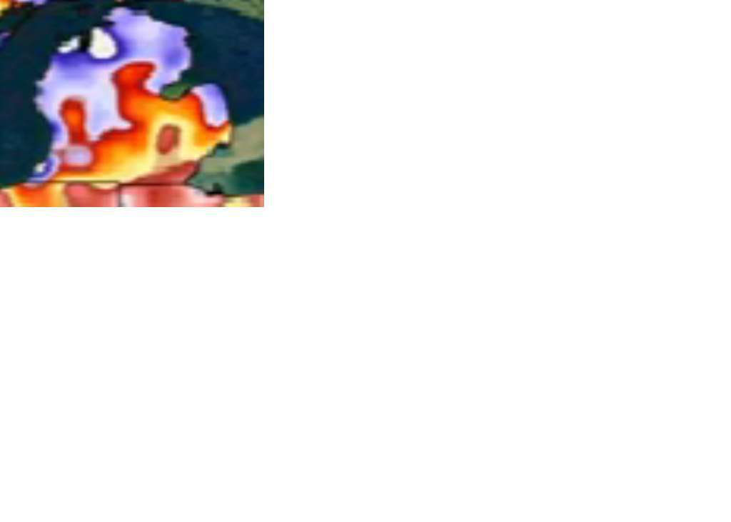
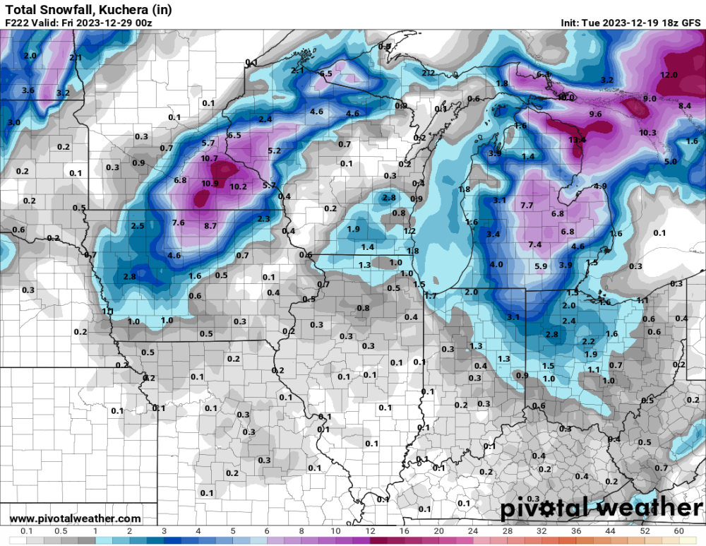
Note 1981-2010 map
-
 1
1
-
On 12/20/2023 at 8:47 AM, OttumwaSnomow said:
Wow thanks @Grizzcoat for this data. It feels like if the avg was looked at in 2011 it would be considerably over 40" but from 2012 to now considerably under 30". I strongly feel the July to Sept months have greatly decreased here. We have averaged mowing each lawn 8 to 18 times. Instead of the previous 25 to 32 times, which translates into millions $$. 2 lawns east of Ottumwa we only mowed 5 times all season in 2023!!! Irrigating is nonexistent here. We do large commercial lawns. Snow has been more reliable. Another interesting tidbit is OTM hasnt had a month over 4 inches since Oct 2021!! Which mean no runoff. Streams and creeks and some ponds are totally dried up.
So glad I passed on that job offer in Iowa, sounds like Wx Hobbiest Hell!
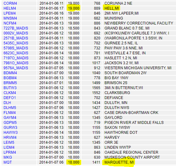
Don't forget tho, there was a time when Hell had more snow OTG than Marquette!
-
1
-
-
10 minutes ago, CentralNebWeather said:
Could get pretty interesting around here if we get freezing rain/sleet before a changeover to snow. We are hosting Christmas, so no visitors for us.
Corrected.
-
3 hours ago, hawkstwelve said:
Only thing keeping my hopes up after looking at those downright ugly deterministic runs is their respective ensembles don't really agree with them. 12z GEFS is actually an increase in mean snowfall totals vs 06z run and is much more generous overall vs the main GFS run. Average for Sioux Falls by end of Christmas day is 1.4 while the deterministic run left me with absolutely nothing.
Could this be a case where the main models pullback on snow chances about five days out only to revert and more closely follow their ensemble guidance 24-48 hours later? Certainly would not be the first (or second, or fifth) time that has happened.
Op should be treated no more importantly than any other ENS member. Basically, that's all it is.
-
3
-
-
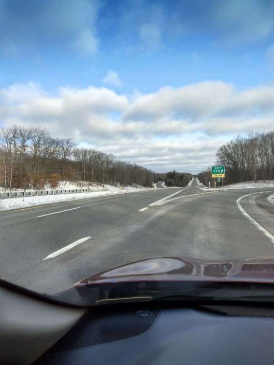
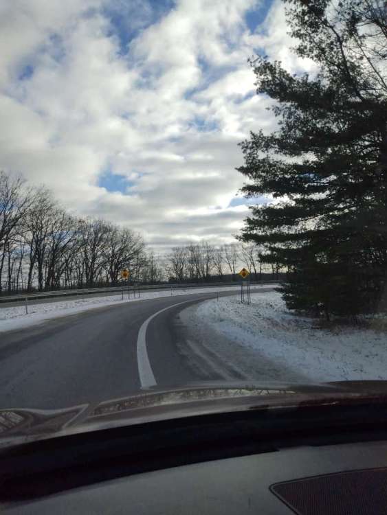
Nice to get one solid winter's day yesterday with snow covered ground and temps solidly below freezing, at least in the Northland where I was prepping the new digs. Couple pics to give an idea what the new region is like.
-
5
-
 1
1
-
 1
1
-
-
15 hours ago, Clinton said:
18z GFS puts down some snow for some on this run. Colder trends.
Glad all that snow over The Mitt is just LR "model static". That would not make for good moving conditions, lol.
-
1
-
 1
1
-
-
17 hours ago, tStacsh said:
Euro would give me a top 5 warm Christmas day. So if it's not going to snow, let there be warmth.
I was too young for 1982 and it obviously won't be close to that 65 degrees, but my Dad still tells me memories of that day. They had a football game in shorts in the field next to my grandparents house. He said it felt like a summer day. Of course the next year the complete opposite happened.
Was a teenager and having had my youth colored with the frigid 70s winters of lore, I didn't know about strong Nino typical effects for our region (72-73 oddly had a cold-n-snowy Dec). The snow lover in me was not at all happy with that historically warm and brown Christmas. In a word, it was a major tragedy to me at the time. Iirc, we did get a dry gust front come through during the evening. Those were a consistent theme that winter as the primary storm track dumped snow on a line from Denver to MSP like clockwork. @gimmesnow would've been going crazy with that winter.
-
 1
1
-
-
Serious winds along the coast with the arctic front:
eliminary Local Storm Report
National Weather Service Grand Rapids MI
1150 AM EST Mon Dec 18 2023

..TIME...   ...EVENT...      ...CITY LOCATION...     ...LAT.LON...
..DATE...   ....MAG....      ..COUNTY LOCATION..ST.. ...SOURCE....
            ..REMARKS..

1050 AM     Non-Tstm Wnd Gst 2 NNW Saugatuck         42.68N 86.22W
12/18/2023  M61 MPH          LMZ845             MI   Mesonet

            Mesonet station XSTK Saugatuck Pier.

0950 AM     Non-Tstm Wnd Gst 2 W Grand Haven         43.06N 86.26W
12/18/2023  M60 MPH          LMZ846             MI   Mesonet

            Mesonet station XGHL Grand Haven Light.
-
 1
1
-
-
Looks like the new place scored decently even though GRR left us out of their WWA's:
Preliminary Local Storm Report
National Weather Service Grand Rapids MI
1206 PM EST Mon Dec 18 2023

..TIME...   ...EVENT...      ...CITY LOCATION...     ...LAT.LON...
..DATE...   ....MAG....      ..COUNTY LOCATION..ST.. ...SOURCE....
            ..REMARKS..

1120 AM     Snow             4 SSE Harrison          43.96N 84.78W
12/18/2023  M3.0 inch        Clare              MI   Public
-
2
-
-
WC's in the upper teens and snow showers blowing sideways stinging the ole face this evening, even here in the Metro. I'd say we saw a few "tenths" of snow today and roads were just starting to whiten-up this evening with a 31F reading right after dark. Was a nice little surprise while it lasted.
-
2
-
-
Baro is pretty low, WC's already in low 20s, and we haven't even got into the expected gusty NNW winds forecasted.
-
4
-
-
Just now, tStacsh said:
Solid 1" down. More than expected with the wave. Add a dusting of a little LES maybe later and it's not too bad of a taste today.
Thx for report, radar looked solid over almost all of SWMI.
-
Wondering if we could get one of these where the two SLPs "connect"?? That would be '78 style wowza
The classic map vs:

-
 1
1
-
 1
1
-
-
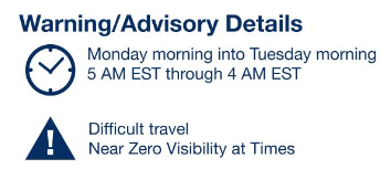
Guess I am not keeping up. I missed this issuance of headlines from DTX overnight for the Thumb region:
Winter Weather Advisory
URGENT - WINTER WEATHER MESSAGE
National Weather Service Detroit/Pontiac MI
357 AM EST Mon Dec 18 2023

MIZ049-054-055-182130-
/O.NEW.KDTX.WW.Y.0010.231218T1700Z-231219T0500Z/
Huron-Tuscola-Sanilac-
Including the cities of Bad Axe, Caro, and Sandusky
357 AM EST Mon Dec 18 2023

...WINTER WEATHER AND HIGH WIND ADVISORY IN EFFECT FROM NOON
TODAY TO MIDNIGHT TONIGHT...

* WHAT...Snow and high wind expected. Total snow accumulation up
  to 3 inches. Winds gusting as high as 45 to 50 mph.

* WHERE...Huron, Tuscola and Sanilac Counties.

* WHEN...From noon today to midnight tonight.

* IMPACTS... Expect bursts of lake effect snow showers and high
  wind to produce hazardous conditions. Increasingly difficult
  travel is expected during the event peak from mid afternoon
  through mid evening. The high wind could also result in damage
  to unsecured objects and localized power outages, especially
  near the Saginaw Bay and Lake Huron shorelines.

* ADDITIONAL DETAILS... A strong cold front will move through
  Lower Michigan during the morning with a mix of rain and a few
  heavier snow showers and wind gusts mainly in the 30 mph range.
  Coverage of snow showers remains highly variable as a northwest
  to north wind increases into the 40 mph range during early
  afternoon. Lake effect snow then increases coverage and
  intensity while peak wind gusts reach the 45 to 50 mph range
  from about 2 PM to 10 PM this evening. Both lake effect snow and
  wind diminish toward midnight and subside even further after
  midnight tonight.
 PRECAUTIONARY/PREPAREDNESS ACTIONS...

Take action to secure outdoor objects from the high wind gusts and
plan for extra travel time this afternoon and evening.
-
2
-
-
1 hour ago, Tom said:
Happy Monday all! I sorta slept in today and had a late start but I just wanted to come on here and say "Giddy up, Buckle Up"....sh$T is gonna get real here the day after @jaster220 moves into his new home in the Northland!
FYP
(on a side note, have snow-globe flakes falling now = very nice!)
-
2
-
1
-
-
1 hour ago, westMJim said:
Some Christmas day weather history. At this time the forecast for Christmas day has highs in the upper 40’s to low 50’s. That would be one of the top 10 warmest highs for any Christmas at Grand Rapids the record is 65 in 1982. But at the current time 3 of the top ten are 55 in 2019 (3rd warmest) 52 in 2021 (4th) and 46 in 2015 (10th warmest) note anything 46 or above would be in the top 10.
If last year's arctic blast would've been just 1day later, I'm pretty sure it would have been a top 10 if not a top 5 cold Christmas day. Nature flipping the script again this year.
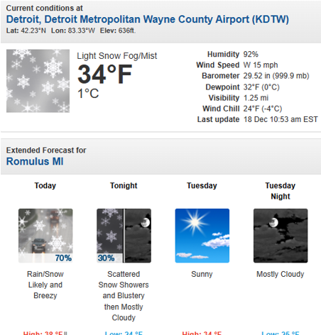
DTW officially hit 15F, but it wasn't that "hot" where I was, lol

-
3
-
-
smallish flakes coming down here as well, so I have at least scored the mood flakes as anticipated from this. Anything beyond will be a bonus as far as I'm concerned. Just peeked at radar and snow appears to be falling at all (6) of my prior/future addresses this morning. That won't/don't happen very often, lol
-
2
-
-
21 hours ago, Tom said:
It slipped my mind to look at the new JMA seasonal so I'll share the 500mb charts below...pretty much all systems a "GO" as we Ring in the New Year of 2024. If these maps come close to being accurate, it'll be a LONG winter this year as we enter MET Spring. As JB says, Delayed but not Denied...
JAN...

FEB...

MAR...

Is there any data on how accurate the JMA is (skill score, etc) on these seasonal forecasts? I don't think anyone has been calling for a cold winter, let alone a "locked-in" cold winter with the Nino still raging. I'd like to have a better understanding if this is just more "model bias" in favor of our thirst for #realdealwinter?
-
Makes me wish I could shift into chase mode
-
1
-
-
Chicago at slight risk of getting MAUL'd per LOT
This is in response to what appears to be a secondary disturbance
centered around 700 mb races south-southeastward from
southeastern WI and southern Lake Michigan. The presence of a
Moist Absolutely Unstable Layer (MAUL) through the DGZ (-12 to
-18C layer), along with strong winds up to 45 kt off the surface
certainly supports the idea that a quick moving and potentially
dangerous snow squall with strong winds and very low visibilities
could occur early Monday morning. At this time, it appears the
best potential area of impact would be across parts of
northwestern IN, but certainly cannot rule out parts of the
Chicago area near the lake getting clipped by this. Trends will
continue to be monitored with this as the timing could be right in
the midst of the morning commute.
-
1
-
1
-
-
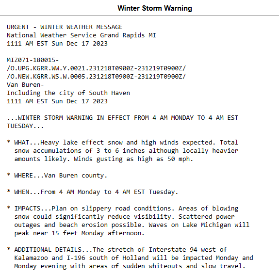
GRR
.UPDATE...
Issued at 917 PM EST Sun Dec 17 2023

We will add Kalamazoo County to the Winter Weather Advisory and
upgrade Allegan County to the Winter Storm Warning. High res
models continue to show lake effect snow bands persisting through
Allegan and Western Kalamazoo Counties for several hours on Monday
afternoon and evening during the period of high winds, so the
combination of falling and blowing snow is expected to create
hazardous travel conditions in Allegan County and this could
extend into the western half of Kalamazoo County. The valid times
will be the same for the existing advisory/warning.
-
2
-
-
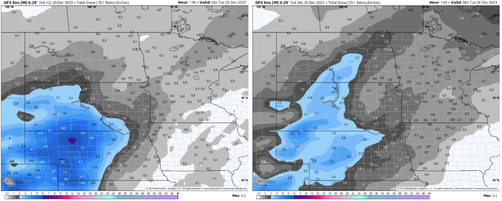
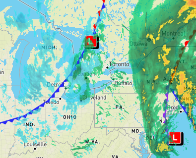
Surprisingly snowy look tomorrow for MI even if it is a "one day wonder"
-
1
-
1
-
-
10 hours ago, Hoosier said:
Maybe it's just me, but I'd rather be able to look at Christmas decorations with snow.
Nothing better than having your lawn decorations buried!
-
Well, that escalated quickly.
SWMI
-
3
-
2
-
 1
1
-
1
-


DECEMBER 2023 Observations and Discussion
in East of the Rockies
Posted
Been snow OTG all week, and now this.
Certainly not deep, but a lot more like winter than elsewhere.