


Bryant
-
Posts
2998 -
Joined
-
Last visited
-
Days Won
14
Everything posted by Bryant
-

MJO/LR Forecasting Thread
Bryant replied to Bryant's topic in Climate, World Weather, and Earth Sciences
I love the work you put into these posts! I love seeing the feedback I've seen so far with this thread, and having someone else make forecasts alongside me using the MJO is a great learning experience for the both of us. As far as the rest of the month goes, I've had the 1-10th as my time frame for cold for a while now. I'm still waiting for the models to show a solid secondary shot of cold air, as I think it's a definite possibility. The last 2/3 of the month in my opinion will be pretty dull, with the bulk of the cold East of the Rockies. Keep in mind, that the CPC composites you use aren't 100% the way to go. There are other resources out there as well, and I try to make the best of all of them. I'm hoping the MJO shows signs of a new wave once this wave dies off, then we can begin estimating our time frame for January -
MJO/LR Forecasting Thread
Bryant replied to Bryant's topic in Climate, World Weather, and Earth Sciences
Wanted to touch base on the ECMWF forecast you mentioned. As with any forecast, data becomes less reliable the further in time you go. Often times, the MJO wave is shown to die off in the dynamical forecasts, only to strengthen as we get closer. As far as our windows of opportunity, you may have a point. However, given the warm SST's and El Nino regime, the MJO propagates much quicker, resulting in more potential shots of cold. We saw cold in November, and now cold is coming for the beginning of December. Will January be the memorable month this year? -
MJO/LR Forecasting Thread
Bryant replied to Bryant's topic in Climate, World Weather, and Earth Sciences
Hey Phil, Took forever to respond, sorry about that. When I mentioned "convective budget", I was simply referring to the amount of convection currently in the tropics. From the papers I've read, a "wet" convective regime will slow down an MJO wave, and a "dry" suppressed regime speeds it up. This goes for La Nina's and El Nino's in general, as the MJO propagates quicker in El Nino's vs La Nina's. Still digging into research and far as the reasoning behind this however. I tend to favor January over December as well, purely due to more available cold. However, this MJO wave looks to deliver the cold as expected. I'm curious to see if we still see another cold shot begin to show on the models while the tropical forcing is still around the MC. Definite possibility. -
MJO/LR Forecasting Thread
Bryant replied to Bryant's topic in Climate, World Weather, and Earth Sciences
Definitely looks like a tight gradient on a few of the model runs. The northern locations may get lucky, but it's borderline at this point. Given the warm SST's, the MJO cycle duration is at it's shortest, around 30-40 days. Lack of convective budget with a weak walker cell increases the propagation speed. At this point, I say our window of opportunity is ~Dec 1-10 while the MJO is centered around the Maritime Continent. After that, convection moves into the Pacific, with cold favoring the Central US at first, then shifting into the East. What happens from there is up in the air. Not saying we can't see any cold, just that tropical forcing favors warmth in the west for 2/3 of December. If a new MJO wave initiates over the IO, given the current MJO duration, early-mid January could be our next major window of opportunity, which lines up with the LRC so far this season. I was linked a great article by @webberweather, which illustrates the MJO cycle duration by month. Keep in mind, as mentioned above, cycle duration is on the low end this season. http://journals.ametsoc.org/doi/pdf/10.1175/JCLI4230.1 http://i.imgur.com/SLq3wCl.jpg -
MJO/LR Forecasting Thread
Bryant replied to Bryant's topic in Climate, World Weather, and Earth Sciences
Much appreciated Jim. I enjoy studying the MJO, as I feel it's a driver a lot of people look past. I like having yourself and others post their thoughts as well. I'm making all these charts with the spreadsheet I sent you MJO 5/6/7 is ugly by the way... http://i.imgur.com/8ycNU0P.gif -
MJO/LR Forecasting Thread
Bryant replied to Bryant's topic in Climate, World Weather, and Earth Sciences
Appreciate the kind words. Potential is there... Just needs some tweaking! -
MJO/LR Forecasting Thread
Bryant replied to Bryant's topic in Climate, World Weather, and Earth Sciences
Mike Ventrice posted this on his twitter, thought I would pass it along.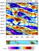
-
MJO/LR Forecasting Thread
Bryant replied to Bryant's topic in Climate, World Weather, and Earth Sciences
No other filters were used. Tends to narrow down the matches a bit too much the more factors I add in -
MJO/LR Forecasting Thread
Bryant replied to Bryant's topic in Climate, World Weather, and Earth Sciences
Taking the above ENSO criteria (warm neutral), plotting a 500mb analysis of the MJO in phases 4/5 yields results which show potential, but has lacks the amplification we'd like to see due to an ugly +EPO which the models have shown for a while now http://i.imgur.com/fBhSpJv.gif -
MJO/LR Forecasting Thread
Bryant replied to Bryant's topic in Climate, World Weather, and Earth Sciences
Quick cross reference here.... http://theweatherforums.com/index.php/topic/663-november-2014-observations-for-the-pacific-northwest/?p=43771 Wanted to throw a composite together real quick, and was pleasantly surprised at how well it lined up. Currently, the MJO is in phase 2, headed to 3 shortly http://i.imgur.com/VLma0Ni.gif Using a database of teleconnections/ENSO/MJO/GWO/etc I have put together, I filtered for dates which featured current ENSO conditions (warm neutral), as well as the MJO in phases 2-3. This left me with about 250 dates, which I then plotted a 500mb analysis of: http://i.imgur.com/nUm5zIX.gif Finally, today's ECMWF 500mb map. Cold anomalies in the NE as well as the SW, with warmth over the north http://i.imgur.com/g2z901E.png -
MJO/LR Forecasting Thread
Bryant replied to Bryant's topic in Climate, World Weather, and Earth Sciences
Much appreciated -
MJO/LR Forecasting Thread
Bryant replied to Bryant's topic in Climate, World Weather, and Earth Sciences
Thank you for answering that one. When I see an MJO forecast throw itself into reverse, I typically throw out that solution until it comes into line. Ex: GFS vs. ECMWF -
MJO/LR Forecasting Thread
Bryant replied to Bryant's topic in Climate, World Weather, and Earth Sciences
As of now, I'd ignore the GFS all together just by going off of the MJO forecast. -
Good times!
-
MJO/LR Forecasting Thread
Bryant replied to Bryant's topic in Climate, World Weather, and Earth Sciences
http://www.atmos.albany.edu/student/nschiral/research/gwo/gfsgwo_2.png -
MJO/LR Forecasting Thread
Bryant replied to Bryant's topic in Climate, World Weather, and Earth Sciences
Appreciate the research. I've been preaching the Euro recently due to it's MJO progression. Much more in line with what I've been thinking, and I believe the other models are starting to build an MJO wave now as well. Whenever you see an MJO forecast completely reverse it's counter clockwise rotation, it should raise a red flag. -
MJO/LR Forecasting Thread
Bryant replied to Bryant's topic in Climate, World Weather, and Earth Sciences
Appreciate the kind words -
What is the MJO? How does it affect the weather? The MJO is a 30-60 day oscillation which measures the suppressed and convective rainfalls over the warm waters of the Indian and Pacific Ocean. The MJO typically initiates in the Western Indian Ocean, and travels east at approximately 4 to 8 m/s (9 to 18 mph) until it dies out over the Pacific. These storms produce a latent heat release to the north, which initiate an increase Jet Stream, causing a favorable area of cyclogenisis to form to the east. This low pressure system pumps up a ridge to the east, which ultimately results in a downstream trough. I found 2 different images from the previous thread, which illustrate the above in a visual manner. As you will see, where you find the convection, you will find an increased jet stream to the north, followed by a ridge and downstream trough. http://i.imgur.com/IsZPCDF.gif How does the MJO affect OUR weather? It may be difficult to tell in the images above, but typically when convection is around the MC (Maritime Continent), the downstream trough is located over the West. The MJO affects change during the season, but during the winter time, phases 3-6 are favorable for the west. I threw together the following image to show the different regions to the best of my ability. This image also demonstrates why you see the MJO favor different zones during different ENSO events due to the shifting of warm and cool waters. http://i.imgur.com/t5BjxrE.gif Pineapple Express As some of you may already know, the Pineapple Express events we receive are directly related to the MJO. As the intense rainfall spreads over the Pacific nearing the end of an MJO cycle (phases 7-8), the moisture gets picked up in the jet stream, and aimed directly at the coast. For the visual learners like myself, here is an image I found online. As you will see in the (7-10 Days Before Event) image, the convection is just east of the MC. Note the similarities to one of the image posted above with the yellow boxes, which also features convection just east of the MC. http://upload.wikimedia.org/wikipedia/commons/a/a7/Mjo_north_america_rain.png Tracking the MJO There are many ways of tracking the MJO, CPC's site probably being the most popular. However, viewing those forecasts can be deceiving due to other tropical waves. The RMM index used by CPC measures the clouds and winds at the upper and lower levels of the atmosphere to determine the strength and location of the MJO. Other waves such as CCKW's (Convectively Coupled Kelvin Waves) project onto the RMM indexes, giving a false reading of the actual MJO. I refer to these forecasts as unfiltered. Filtered forecasts on the other hand attempt to separate individual waves using their own formulas. These forecasts aren't perfect, but do a much better job in my opinion than the unfiltered forecasts. Here are a few links for unfiltered and filtered forecasts. CPC Unfiltered Multi Model Unfiltered Kyle Macritchies 30 Day CFS MJO Roundy Waves Filtered Mike Ventrice's Site
-
That's the spirit! ... not
-
This place is thrilling right now!
-
Freeways over by Lakeway and Samish are covered per the DOT cams
-
Except false hope
-
Their dewpoint is really low though*
-
Huge differences as far as snow totals up north. Doesn't look the same at all
-
We've seen this before, and as Phil has mentioned, the op should be used when closer to the event. It's a higher resolution, and typically does better.

