SalemDuck
-
Posts
368 -
Joined
-
Last visited
Everything posted by SalemDuck
-
PNW November 2021 Wx Obs/Discussion
SalemDuck replied to Meatyorologist's topic in West of the Rockies
The GEM made some nice improvements -
PNW November 2021 Wx Obs/Discussion
SalemDuck replied to Meatyorologist's topic in West of the Rockies
Big block in the long range. Need to move that east about 15 degrees
-
PNW November 2021 Wx Obs/Discussion
SalemDuck replied to Meatyorologist's topic in West of the Rockies
At least Phil’s Scandinavian ridge is still there
-
PNW November 2021 Wx Obs/Discussion
SalemDuck replied to Meatyorologist's topic in West of the Rockies
You’re going to look like a genius or the village idiot. -
PNW November 2021 Wx Obs/Discussion
SalemDuck replied to Meatyorologist's topic in West of the Rockies
Last night’s extended GEFS control run is a Jan 1950 type run. -
PNW November 2021 Wx Obs/Discussion
SalemDuck replied to Meatyorologist's topic in West of the Rockies
-
PNW November 2021 Wx Obs/Discussion
SalemDuck replied to Meatyorologist's topic in West of the Rockies
Good trends on the teleconnections. Mid December looks to be a good window. -
PNW November 2021 Wx Obs/Discussion
SalemDuck replied to Meatyorologist's topic in West of the Rockies
The Euro is definitely not agreeing with the GFS on the Sunday-Monday trough but it's definitely trended it to the SW, while amplifying the ridging. -
PNW November 2021 Wx Obs/Discussion
SalemDuck replied to Meatyorologist's topic in West of the Rockies
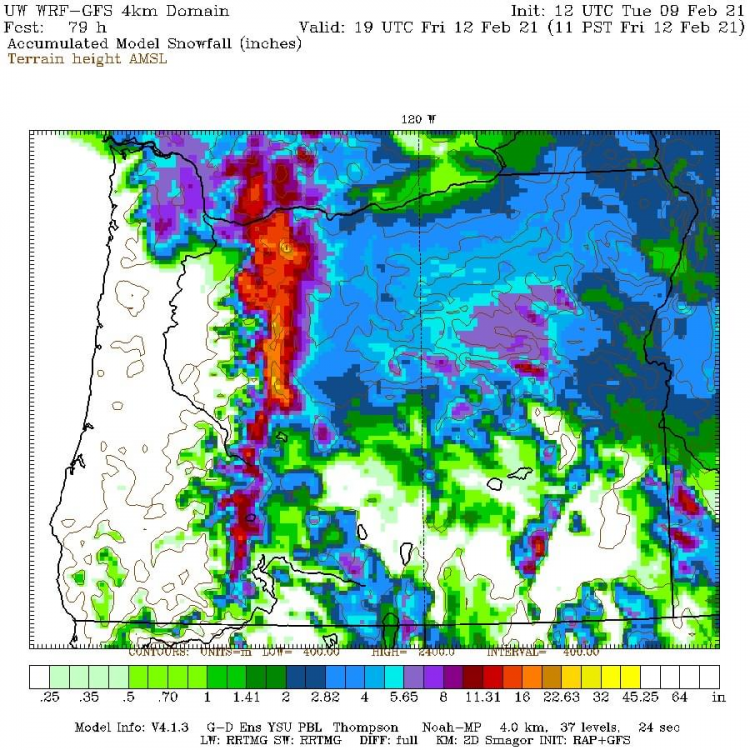
Final snow map... -
PNW November 2021 Wx Obs/Discussion
SalemDuck replied to Meatyorologist's topic in West of the Rockies
It was PDX south basically, mid-Willamette valley was the bullseye I believe. -
PNW November 2021 Wx Obs/Discussion
SalemDuck replied to Meatyorologist's topic in West of the Rockies
Flow is offshore, 925mb temps -3, 850mb temps -3/-4 and 34 at the surface, pretty good precip rates. It's realllllllly close. -
PNW November 2021 Wx Obs/Discussion
SalemDuck replied to Meatyorologist's topic in West of the Rockies
EPS weeklies are pretty good, I'm sure we'll get a decent shot at something between mid December and mid January.
-
PNW November 2021 Wx Obs/Discussion
SalemDuck replied to Meatyorologist's topic in West of the Rockies
EPS continues to show serious cold building over eastern Alaska/Yukon/northern BC during the second full week of December. Ridging is centered way too far west for it to matter plus a raging + EPO. -
PNW November 2021 Wx Obs/Discussion
SalemDuck replied to Meatyorologist's topic in West of the Rockies
Very few members send it to an okay spot
-
PNW November 2021 Wx Obs/Discussion
SalemDuck replied to Meatyorologist's topic in West of the Rockies
Florence please. -
PNW November 2021 Wx Obs/Discussion
SalemDuck replied to Meatyorologist's topic in West of the Rockies
euro sends the system into Vancouver Island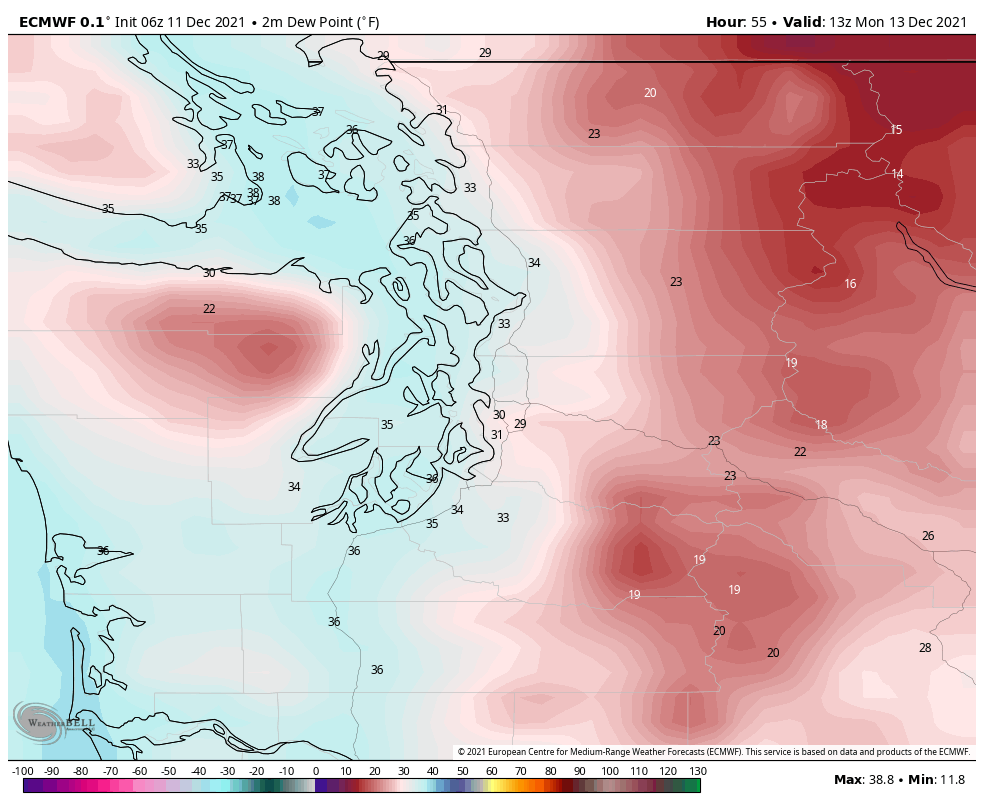
-
February 2021 PacNW Weather Discussion
SalemDuck replied to BLI snowman's topic in West of the Rockies
Fwiw considering it’s temps the HRRR puts the low at Waldport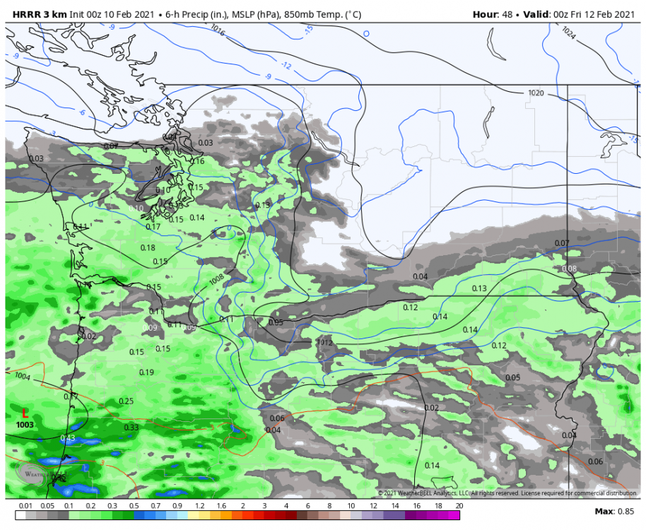
-
February 2021 PacNW Weather Discussion
SalemDuck replied to BLI snowman's topic in West of the Rockies
Does the extended HRRR have a big warm bias cause good lord this would be a non event for everyone?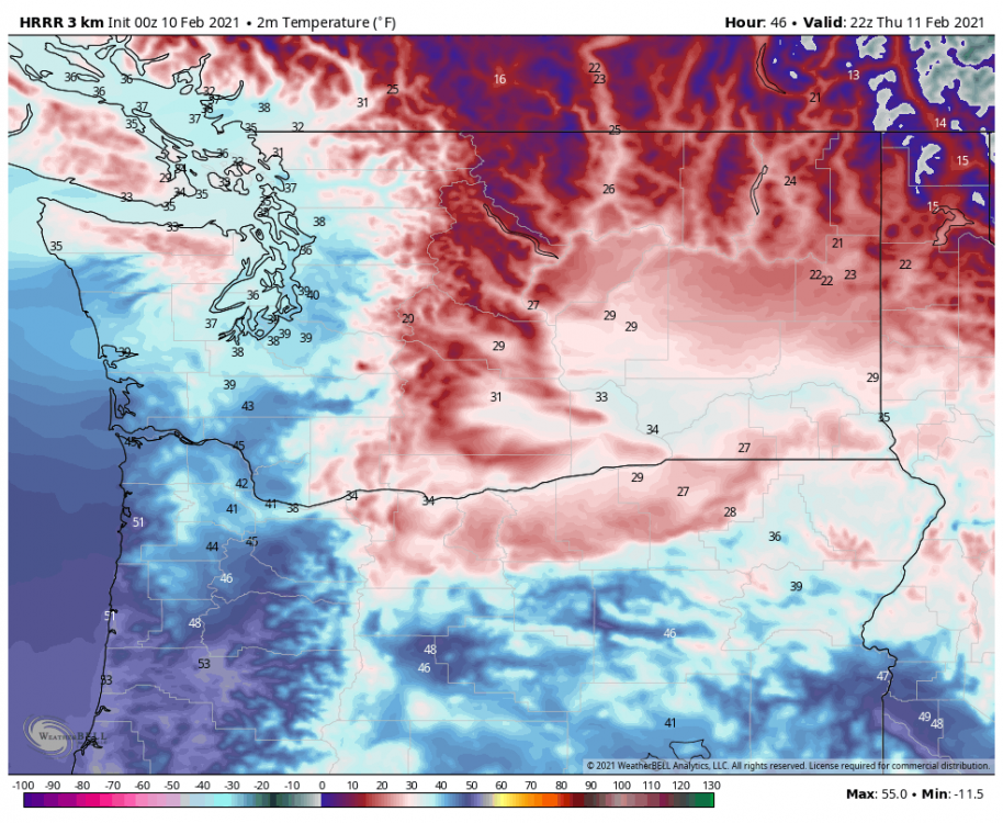
-
February 2021 PacNW Weather Discussion
SalemDuck replied to BLI snowman's topic in West of the Rockies
Spokane International same thing. Supposed to hit 30, only hit 25. Omak was supposed to be 28, only hit 25. -
February 2021 PacNW Weather Discussion
SalemDuck replied to BLI snowman's topic in West of the Rockies
Euro isn't handling the low level cold well imo. I'd take my chances with the track it's offering -
February 2021 PacNW Weather Discussion
SalemDuck replied to BLI snowman's topic in West of the Rockies
Euro had them at 28 today. -
February 2021 PacNW Weather Discussion
SalemDuck replied to BLI snowman's topic in West of the Rockies
18z Fully Drunk -
February 2021 PacNW Weather Discussion
SalemDuck replied to BLI snowman's topic in West of the Rockies
GFS v16 is back and has Florence and Coos Bay landfalls for the two systems. It buries Olympia to Salem.
-
February 2021 PacNW Weather Discussion
SalemDuck replied to BLI snowman's topic in West of the Rockies
Euro has already begun underestimating the arctic air. Here's the last three runs at what was initialization (4am) this morning. Today Last night's euro Yesterday's 12z -
February 2021 PacNW Weather Discussion
SalemDuck replied to BLI snowman's topic in West of the Rockies
This is a more accurate map imo