Meatyorologist
-
Posts
9077 -
Joined
-
Last visited
-
Days Won
13
Everything posted by Meatyorologist
-
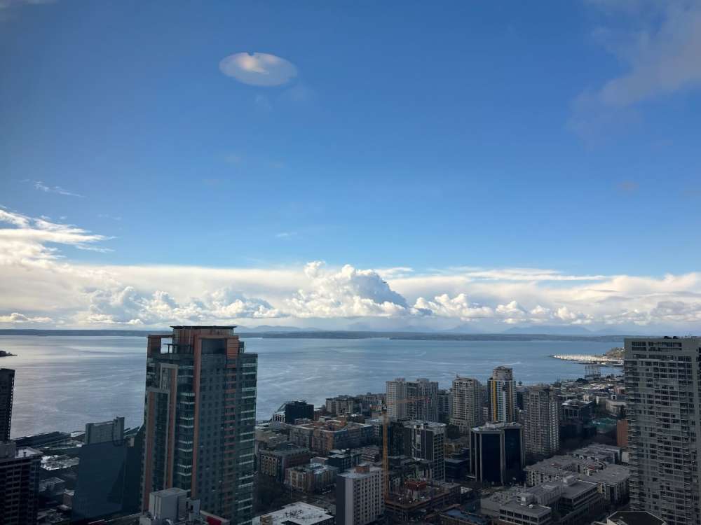
 Back to the Puget Sound, today was a wonderful day for skygazing off the top floor. Working in an Amazon building has its perks. Driving home today around 7pm, there was a burst of heavy rain/snow mix at sea level in the Interbay neighborhood within the CZ. Most models, including (especially) the Euro, are insistent on some wraparound snowfall in the area later tonight. Given how saturated this airmass is, any lift will cause precipitation. Also @RentonHill dawg there is no way you work more than like two blocks away from me. Looking at your posts earlier I recognized that vantage point like the palm of my hand. Westlake right?
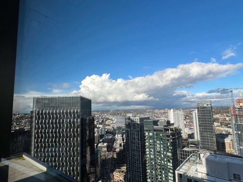
-
Doinko, 8" is only the beginning of your potential tomorrow night.
-
I am ready to eat crow on this one, but I'm exceedingly bullish on this. Put it on the record. Sitting in my bedroom 200 miles away I am vicariously excited. This is the real deal. Yeah, the real deal real deal. And all who live in the area, or just like to see extreme weather events play out in real time, should be paying close attention to radar and satellite over the following 36 hours.
-
I'm just astonished at how anemic these mesoscale models are for the PDX area. This is a textbook setup for an overperformer on steroids. Someone not an hour ago brought up 1/10/2017 as an analog. That is fair and accurate.
-
Everyone in the Willamette from Salem up to Vancouver better be getting excited. I only reserve this kind of language for the most impressive setups, but I am highly confident someone in this area will recieve an excess of a foot of snow. And it may be a larger area than you think. From what I am seeing on satellite, sfc obs, radar trends, this is big. An organized low wrapping and stalling just to the SW of the PDX metro area. A stout Arctic frontal boundary stalling along with it, also right over the area, for more than twelve hours potentially. And to top it off, moist SW'lies running into and overhead this boundary, with lapse rates above the sfc Arctic outflow remaining negative. That is BIG. Any met in this climate knows this is a red flag setup for a highly impactful snowfall. It may not be Portland, but it will be someone. And they will get fkn nailed
-
Talk about a bullseye for my location!! lmao
-
1...2...3...4...I declare a prefence war!
Meatyorologist replied to Chewbacca Defense's topic in West of the Rockies
My roommate owns an orange Scion xD -
Those mountains have been sort of shafted this winter compared to the Sierras, often getting the warm sector of the storm track. Nice to see them score a cold system, too.
-
Gonna be with a maritime airmass, and will therefore be more marginal. Also, temperatures will rise well above freezing Wednesday afternoon, so there will be more significant melting than if it were to fall Wednesday night, since Thursday will struggle to hit freezing.
-
This is a pretty satisfying progression. Our low in question is noice and vertically stacked.
-
Our weather forecasts for snow, wind, and convective events are pretty trash. I do not blame the ribbing... Though most of it comes from a place of misunderstanding. The people most likely to get all vocal about how unreliable meteorologists are, are also the same people who are most naive of the science, methodology, and reasoning behind weather forecasting. But when we can almost never predict snow events to an acceptable degree of accuracy, even just hours in advance, it severely undermines public trust. And to make matters worse, the best way to compensate for this deficiency is to give into this narrative, and completely and totally admit that we have no idea what is going to happen. Because even assuming we have the weather pattern and progression down to the tee, our forecasts are still *extremely* vulnerable. Local terrain features, convective surprises, minor QPF fluctuations, and minute differences in timing all have the potential completely derail our predictions.
-
Night and day.
-
The Portland area is a tough call, but betting against the Euro is a fool's game usually. Somewhere in the Willamette is about to get slammed. This will be an OR centric event, with some localized winners in the Evergreen state was well.
-
Hmmmm... That is much more generous for the Sound than I initially expected. This model is usually wayyyyy too dry. Upon closer inspection, it all falls when temps are between 34-36F. And after that it dries out fast.
-
As is usually the case, we will spend hours of our lives agonizing over whether we will recieve one, two, five, or however many inches of snow. But when the first flakes start falling, and the branches get that first thin layer of dust, the light from the streetlamps sparkling all over the brand new transformed world, now separate from the monotony of daily life, we will all remember that it doesn't really matter. Half an inch is all it takes. The jokes write themselves, I know, but I mean the message. Even just half an inch of snow absolutely transforms the world, especially if it accumulates on pavement.
-
I can't speak for the majority of the Sound, but my winter experience thus far has been a small amount of very high quality snow. All of it has stuck around for at least a few days, and 2"; nearly half of this winter's cumulative bounty; fell during a highly dynamic transition while below freezing, and ushered in a 26/15 spread the following day.
-
The NAM and the ICON both handle the low weird, you can throw those solutions out. The GFS is most surely too aggressive by a long shot with the advancement of Arctic air (that issue seems to have gotten worse in its recent update for some reason.) The CMC, rather, is probably too anemic in this regard. The Euro, to the surprise of just about no one, is likely on point in terms of pattern progression, low placement, temperatures, and precip distribution; although it's probably a fair amount too dry on the transition Wednesday into Thursday. Precip coverage will likely be much higher than modeled, and precip intensity/snowfall depth will be pretty heterogenous, even in areas that will benefit from frontogenesis more than convection, simply because this airmass has some #meat to it (something I in particular quite approve of), and there will be surprises hiding about. I wouldn't be surprised if many in the region wake up Thursday to a wacky, confusing commute, driving in and out of areas with locally intense snowfall, going from bare to pushing half a foot in a matter of a few miles, without much elevation change or change in proximity to large bodies of warm water.
-
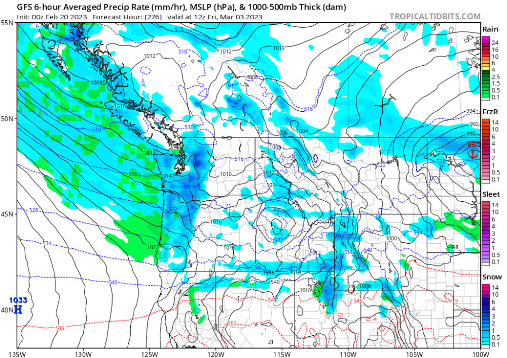
Absolute BEAST of a maritime trough on the 00z GFS fantasy range.
-
Wow. That's the EPS mean??! That is awesome to see this late in the winter, especially without the aid of existing snowcover. If we were in January right now, the extended would be looking pretty silly too.
-
I am!
-
I thought it didn't precipitate down there..
-
A damp walk in the forest around your property would probably lift your spirits! Lots of little beautiful things to notice in the gray, still environment.
-
It's like being under a cold misting machine for days on end! Most would find that horrendous, but given how this isn't really melting any Cascade snow, and that it's not really uncomfortable outside, I actually find this to be a pretty nice weather pattern.