


Meatyorologist
-
Posts
9067 -
Joined
-
Last visited
-
Days Won
13
Everything posted by Meatyorologist
-
 Okay some time has passed and my white hot rage has subsided. I did yell a lil bit, and aside from tossing a few pieces of furniture around and making the neighbors cry, I think I'm good now and mostly under control. SO say the police. Anyways. I do not think you have any malicious intent with your warm EPS maps. I'm just saying, it sometimes makes you into the 'well, ackshyually" type of poster and it's a downer for a lot of people.
 -
As someone who lives in the Seattle metro area, I'm pretty psyched for this upcoming week. Should be quite rarified cold for this time of year and plenty of snow opportunities to go along with it. Hoping for surprises, as well as that THUMPING of snow on the Euro to verify for Portland.
-
When half your posts are shidding on people's innocent excitement for snow and cold, and you have multiple members calling you out on that, and dozens of others agreeing, maybe it's time to look inward and reflect on your actual intentions. For what it's worth, this map looks great. A smoothed ensemble mean of a 5-day average more than a week out, still bringing in 'candy apple' negative temp anomalies to much of the PNW; it's nothing to dismiss. At the very least this looks rife with marginal snow opportunities up and down the westside.
-
06z GFS is a good one for emeralds.
-
If we transitioned to +ENSO more rapidly this year, could we expedite the whole ENSO warm phase and get it over with sooner?
-
18z dashing NOW
-
I got accepted into the University of Oklahoma!
Meatyorologist replied to Iceresistance's topic in Off Topic
Rock that stuff congrats!! -
Nice theme of introducing a deformation-esque feature over western WA. More typical of our classic snowfall setups.


-
00z ONGOING
-
That 2010-11 analog is looking better again.
-
I can't help but feel entirely responsible. Fred is mostly absent and Phil/Hawks12 hardly engage with the western forum at all...neither of them live in the PNW. It was me who could have done something early on and chose not to, hoping just letting it go would work. It was a weak decision made by lazy intentions. I haven't been all that present lately due to my own personal matters, but that shouldn't culminate in one of our own members leaving because they feel grossed out and uncomfortable. That's my bad..my fault. It never should have come to that point.
-
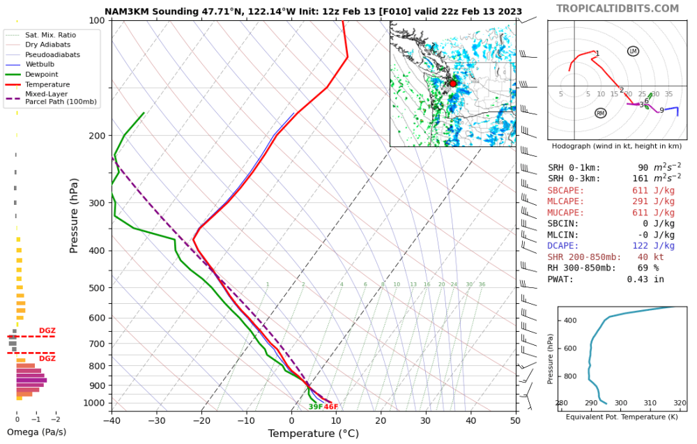
Lol, it creates a lil QLCS, with a low behind the convective line and everything. I've noticed this structure plenty of times before in PSCZ events.
-
The NAM tries to bring through a nice PSCZ convective band in a few hours. With an environment like this, there would likely be lightning, hail, heavy downpours, and pockets of wet snow.
-
The meteorological committee of Sharon Springs, KS was one of the largest financial backers for the production of the 96th hour of tonight's 00z GFS.
-
Coincidentally, the last time I hosted a party that cold was also the last time I had any guests over.
-
That guy probably reserves one sleeve in his wallet for a folded printout of the 18z GFS.
-
Can I fetch my snack's snacks?
-
It gets too cold to snow, so it comes back around full circle.
-
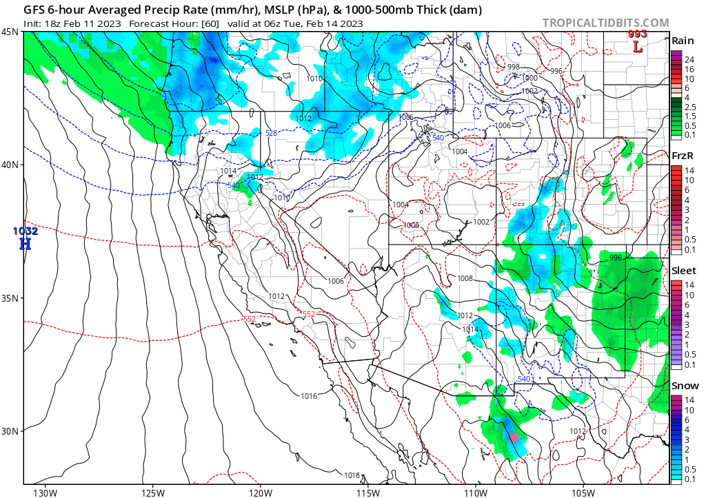
This run might go nuts. Already a big snowstorm for western WA by 306hr with extremely cold air gushing south into BC and a big blocking high blowing up.
-
More good news, this upcoming trough is going to dig into the desert SW and wrap up some subtropical moisture without too much moderation in temperature. This means big snows for UT, AZ, CO, and even into NM, as well as portions of CA and NV.
-
18z BLASTS before 300hr! Similar airmass to Monday's upcoming one for OR, but a fair amount colder in WA, with notable Arctic air into SW Canada.
-
PseaTac pscored a pnice phyphtie-burgure toudey!
-
Gorgeous. A bit excited for this one now.
-
That BEARD is LEGENDARY


