


Grizzcoat
-
Posts
4887 -
Joined
-
Last visited
-
Days Won
16
Everything posted by Grizzcoat
-
This storm and the potential system on Thanksgiving--- never seen so much disparity between the GFS and the EURO. Not my first rodeo , either.
-
-
-
thanks-- was wondering about that.
-
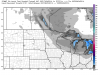
A little more expansive then I thought--http://models.weatherbell.com/ecmwf/2014111700/mw/ecmwf_snow_24_mw_31.png
-
Yeah it is odd. Snows looks (on this run) to be in W.WI - E.MN and N.IA--- the thing that gets me is 985MB low at 168 near Green Bay and no HP to the NW but a 997 low near Bismarck,ND. I know the cold air is missing-- but 997 low as mentioned just seems odd.
-
from DMX AM disco--- THE LATTER PART OF THE FORECAST IS MORE UNCERTAIN AND WILL NEED SOME ADDITIONAL EVALUATION AS A SIGNAL FOR A STRONGER STORM IS BECOMING MORE APPARENT.
-
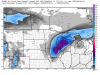
Obviously will change--- but looking at a major event-- 24 hour totals--http://models.weatherbell.com/ecmwf/2014111600/mw/ecmwf_snow_24_mw_38.png
-
Euro = classic Iowa snow event.
-
DMX talking a brutal monday--- (a great discussion from them-- about time) HEADLINES MAY BE NEEDED AGAIN ON MONDAY FOR THE COMBINATION OF WIND...BLOWING SNOW...AND COLD. HAVE EXPANDED THE POTENTIAL FOR LIGHT PRECIP AND BLOWING SNOW MONDAY ACROSS THE AREA. HIGHS WILL RECOVER LITTLE FROM FRIGID MORNING LOWS IN THE SINGLE DIGITS TO LOWER TEENS. BY AFTERNOON HIGHS NORTH WILL REACH THE LOWER TEENS TO THE LOWER 20S IN THE SOUTHEAST. TO TOP OFF THE WONDERFUL DAY...MINIMUM RECORD HIGHS LOOK LIKELY TO BE SET AT MANY LOCATIONS...ONE WHICH HAS NOT BEEN SEEN SINCE THE 1890S AND MANY SINCE THE 1950S. IN FACT...OUR HIGHS MONDAY WOULD STILL BE ABOUT 10 TO 15 DEGREES BELOW OUR COLDEST AVERAGE HIGHS FOR THE NORMALLY COLDEST WINTER DAY OF THE YEAR...OR ABOUT 30 DEGREES BELOW OUR NORMAL FOR 11/17. WE HAVENT HAD HIGHS THIS COLD SINCE EARLY MARCH OF 2014. The min/max for DSM on 11/17 is 17F in 1891
-
I'am with you James. But what a poorly detailed discussion by DMX-- no mention of it in the body. DMX is noted for poor discussion over the years...http://www.hpc.ncep.noaa.gov/wwd/day2_psnow_gt_04.gif
-
00Z GFS has Thanksgiving week system on the 25th-- as mentioned by Anthony at The Weather Centre. ***edit*** the 24th.
-

Season's First Potential Wintry Storm and Arctic Outbreak
Grizzcoat replied to Tom's topic in East of the Rockies
System really tapped into some warm air. 66F here today at DSM-- was only forecasted to be 57-58F. NWS just upped from 30% to 50% chance snow tonight with totals less then 1"--- which is good compared to what it was. At least the grass might get white... -
I know its hour 384 on 00Z Gfs--- but it does show Andrew at Weather Centre idea of a storm for thanksgiving week.
-
the cold on the 00Z GFS is about as impressive as it gets for mid Nov.
-
Season's First Potential Wintry Storm and Arctic Outbreak
Grizzcoat replied to Tom's topic in East of the Rockies
Bueller? Bueller?? Sounds of crickets. Awful quiet in here for storm of this magnitude. -
Season's First Potential Wintry Storm and Arctic Outbreak
Grizzcoat replied to Tom's topic in East of the Rockies
U of M Graduate. Payback for all those blowouts you did to us at Kinnick North. Kinnick North is dust now!! -
Season's First Potential Wintry Storm and Arctic Outbreak
Grizzcoat replied to Tom's topic in East of the Rockies
Last winter by Dec 20th here in C.IA the local media was complaining on how long the winter was. What?? Where I grew up along the Northshore along Superior in MN (where Duluth had 127 consecutive days last winter with at least 14" of snow on the ground) -- people would laugh at that the fact the most amount on the ground here in DSM last winter was 6"--- It's going to be a looooooooooong winter. Please. -
Season's First Potential Wintry Storm and Arctic Outbreak
Grizzcoat replied to Tom's topic in East of the Rockies
Feel the same here in the DSM area. Domink -- RIP. I will be surprised if EURO (hoping) moves South. The energy for this system-- where is it located now?? -
Season's First Potential Wintry Storm and Arctic Outbreak
Grizzcoat replied to Tom's topic in East of the Rockies
Thats great stuff Snowman-- thanks for sharing!! -
Season's First Potential Wintry Storm and Arctic Outbreak
Grizzcoat replied to Tom's topic in East of the Rockies
Ground temps as of last evening from the DSM NWS office-- PUBLIC INFORMATION STATEMENT NATIONAL WEATHER SERVICE DES MOINES IA 545 PM CST WED NOV 5 2014 ...DAILY 4 INCH SOIL TEMPERATURES... .BR DSM 1105 C DH1700/TSIRZZ : :ID LOCATION 4 INCH TEMP : CSAI4 : CASTANA : 47 DVNI4 : DAVENPORT : 51 DMXI4 : JOHNSTON : 44 DCRI4 : DECORAH : 42 ICYI4 : IOWA CITY : 44 KANI4 : KANAWHA : 46 3OI : LAMONI : M NHUI4 : NASHUA : 46 OELI4 : OELWEIN : M TLDI4 : TOLEDO : 42 .END $ Those are 4" temps.. wont take much more cooling. -
Season's First Potential Wintry Storm and Arctic Outbreak
Grizzcoat replied to Tom's topic in East of the Rockies
First post this young winter season-- so that is good being NOV 6th. Loved seeing the 12Z GFS run--)5"+ here in C.IA-- but I believe it's wrong. The Euro has been the most consistent and has superior physics to the GFS-- which is huge with what is transpiring around the globe (SOI index tanking etc-- PV about to get displaced and the adjustment of the seasonal jet(s). Also-- I remind folks that 18Z and 06Z GFS/NAM DO NOT(at least last year they didn't) ingest upper air parameters into the runs-- so take them with a grain of salt. I believe the Euro is locked in and do not see a shift of more then 50 miles N or S. -
2/3-2/4 Southern Lakes/Ohio Valley Winter Storm...
Grizzcoat replied to DominicR's topic in East of the Rockies
Good Luck to all. that's all it is. Seems most on here enjoy winter weather-- even the cold like myself. Why the majority of the general public is so agst cold/snow in this part of the country baffles me-- enjoy it why it lasts--- a brutal summer is coming. IF you had to pick one---Furnace out on a -15F degree night (I heat with wood-- no issues) or A/C out with temps around 100F. Even if I didn't heat with wood,, I would take the winter idea over the summer. WHY-- much easier/more options to heat a home then cool one. A/C out-- your screwed. -
February 7th-9th Possible Winter Storm
Grizzcoat replied to clintbeed1993's topic in East of the Rockies
Missouri at best. A lot can change with event ahead of it and snow cover laid down-- but a South trend would be my .02 -
2/3-2/4 Southern Lakes/Ohio Valley Winter Storm...
Grizzcoat replied to DominicR's topic in East of the Rockies
Yeah-- DSM area needs all the luck it can get for snow events over 4" this year!!! Roughly 24" of snow so far-- OHHH BOy-- but the local news media makes it out to be like it's been such a LONG WINTER. Not in C.IA--- the ground has been bare about 1/2 the days since DEC 1st.


