


Skagit Weather
-
Posts
2302 -
Joined
-
Last visited
-
Days Won
3
Posts posted by Skagit Weather
-
-
10 minutes ago, Port Angeles Foothiller said:
So @TT-SEA you ignored my question for a lookup of Port Angeles Int Airport departures. I don't know how you access departures so I did a round about method. Below is the climate average for the PA airport station from 1991-2020. If you add the rain from Jan-April you land at 11.72"

Here is the reported YTD rain amounts circled below of 7.73". A departure of -4". You can stop gaslighting me now.

You're right. The 25 year average for Port Angeles (1999-2024) for Jan 1 - May 5 is 11.91" and so far only 7.49" have fallen. Interestingly the departure is not nearly as bad for other nearby stations (such as Sequim) so the shadow must have been particularly unusual in the Port Angeles area so far this year.
-
 1
1
-
-
4 minutes ago, TT-SEA said:
Except for @Port Angeles Foothiller backyard of course! He might have put up a transparent dome over his property and not telling us.

It's almost like total accumulated precipitation isn't the only variable that determines drought in the PNW. 2015 had near normal precipitation through the first 5 months of the year and I remember the region having a couple water issues that summer. And maybe if the spring rains stopped early next week and it was near to above average temperatures for the rest of the summer we'd see some of those same issues arise. Maybe rainy days serve multiple purposes...
But it is true, that currently in terms of pure rainfall we are in a much better situation than last spring.
-
 3
3
-
-
1 hour ago, Tyler Mode said:
Nice morning in the mountains.
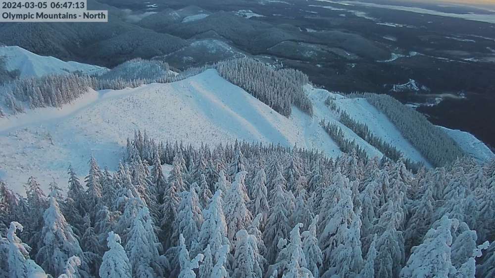
Where can you find that Olympics Mountains North Cam? I've never seen it before, but it looks like a cool perspective.
-
3
-
-
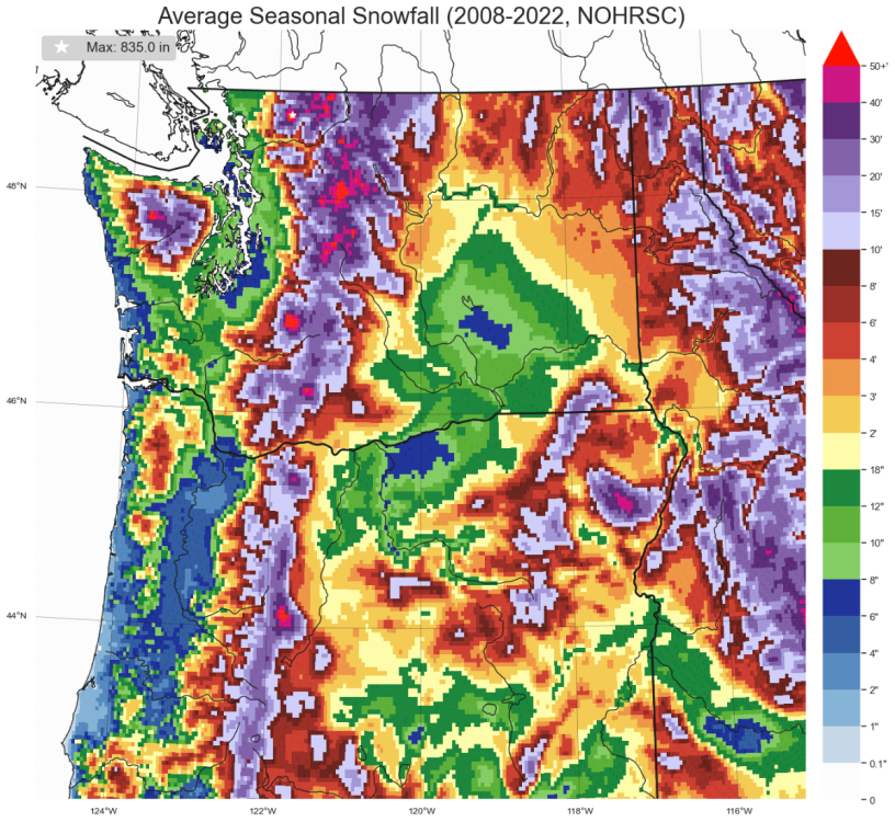
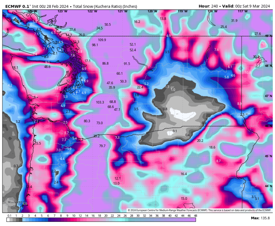
1 hour ago, BlvuSumit said:
Better resolution sorry
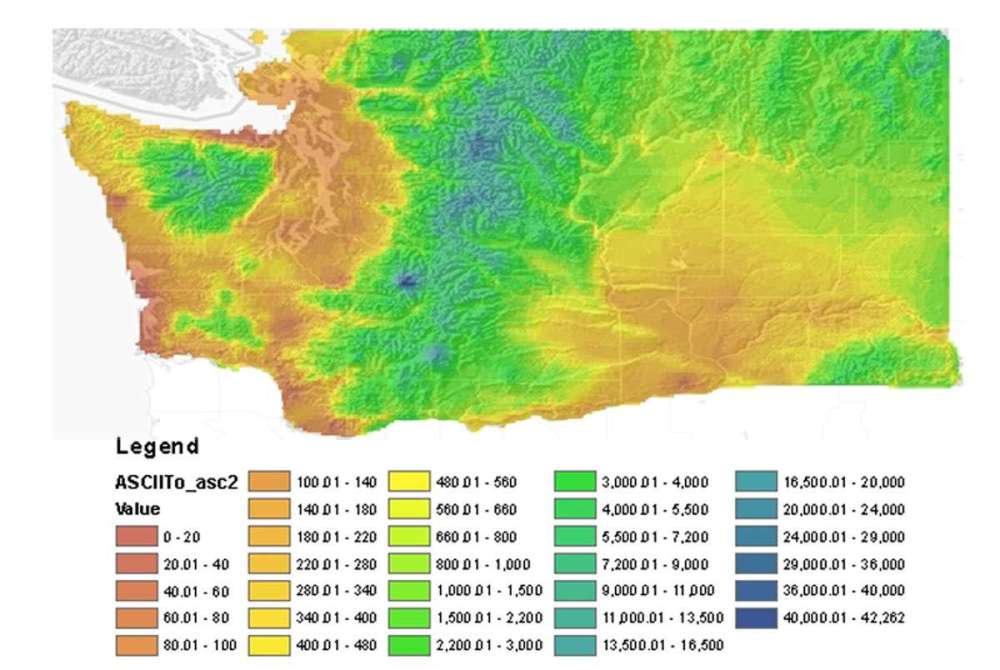
This one I made last year based on data from the National Operational Hydrologic Remote Sensing Center. I haven't updated it with data from 2022-23 yet and it doesn't represent long term averages, but I think does a good job showing about what different areas in the state pick up.
-
1
-
-
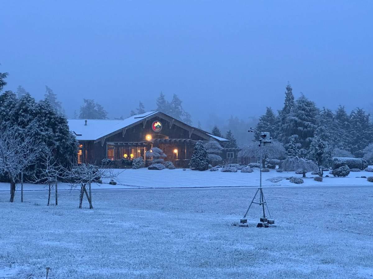
Still only 34F up here with clear skies. I believe it should freeze the next couple of mornings, but considering how hard they've been to get since mid January I'm honestly not entirely sure.
-
1
-
 1
1
-
-
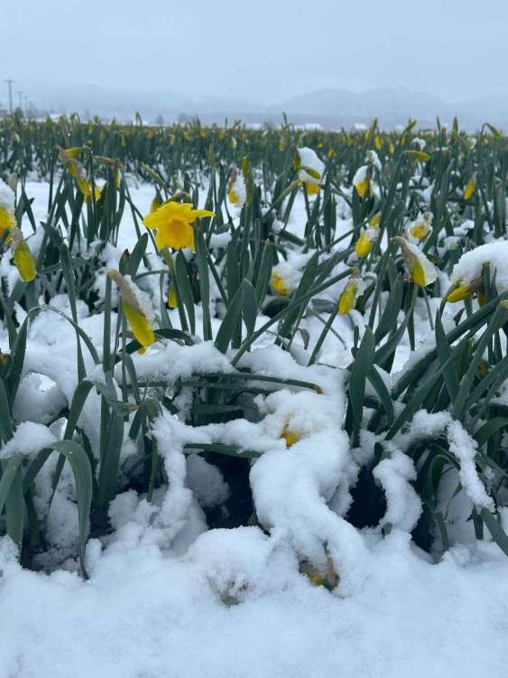
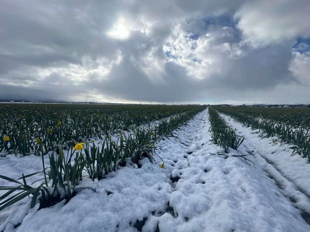
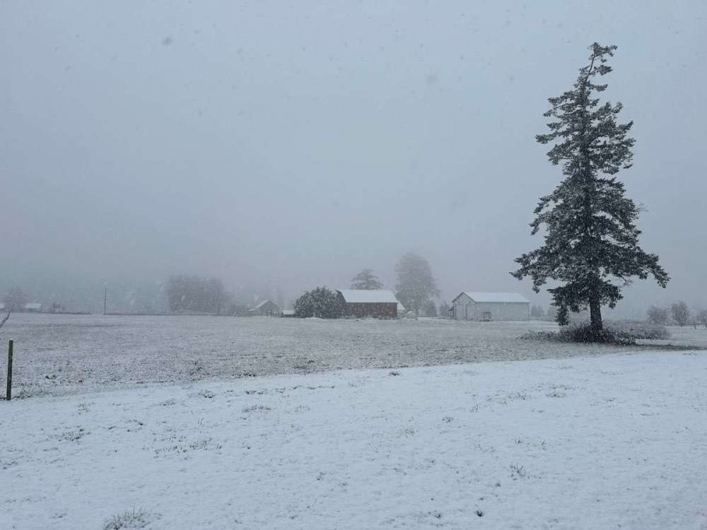
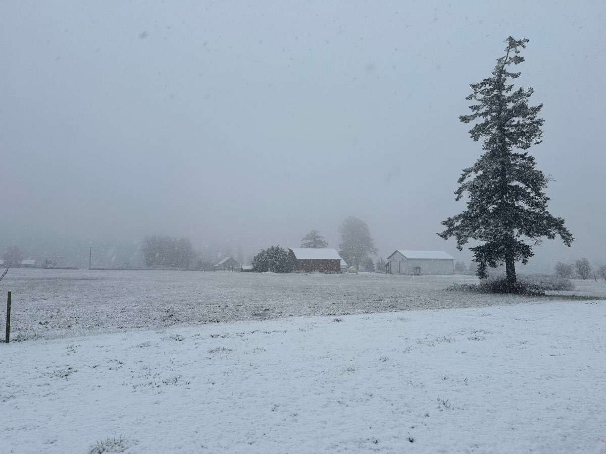
Pretty amazing how quickly a little sun and warm temperatures can wipe out snow this time of year. Not a flake remains of my 2” from this morning, but it was pretty nice to see it. That bumped my total up to 7” on the winter which is 7” more than I was expecting.
I went out to the daffodil fields as the snow was stopping. Pretty cool to see the flowers under a bit of snow.
-
9
-
 1
1
-
1
-
-
22 minutes ago, MossMan said:
Mt Vernon schools just closed.
Burlington just closed as well. Probably should have just kept the 2 hr late start because I'm sure the roads will be fine in an hour or two, but oh well.
-
- Popular Post
- Popular Post
Well, that escalated quickly. Approaching 2” now, although looks like I’m about to run out of moisture.
-
9
-
 1
1
-
The March snow curse is (somewhat) broken! Moderate snow and 32.6F. Approaching 1/2" on the ground. First time I've had any accumulating snow in March since 2017 and I haven't had more than an inch since 2014.
The latest snow I've had here was the 4-6" that fell in mid April 2008. Now that would be something to see a repeat of.
-
5
-
-
Light rain and 34F here but I've heard reports of snow to my east. I bet @MossMan is getting hammered.
-
1
-
1
-
 1
1
-
-
5 minutes ago, lowlandsnow said:
I bet the top of Baker got over 65 inches in 24 hours from this storm. Temps have probably been in the lower teens there given the temps at Camp Muir and I wound assume they received the same amount of precip if not more.
Almost certainly, but it's hard to know whether the summit was above the heaviest precipitation and how much just got wind blasted off the summit.
-
8 minutes ago, skywatcher said:
If the stars somehow lined up, I'd believe it. Crystal is in such a weird place that it takes just the right combination of conditions to make true magic happen.
Paradise picked up 44" that day so it's certainly possible, but it just seems so strange that it would get so much more. I mean honestly, I'm just skeptical of most snow measurements. It's so hard to measure snowfall whether it's from compaction or drifting or too frequent of measurements.
The National Center for Environmental Information, which maintains the US weather records acknowledges that this reading is a bit suspect so they also list a 52" one day reading from Winthrop on 1/21/35.
-
2
-
-
This storm is going to be one of the more impressive ones I've seen in the mountains over the last couple years. At least 31" of new snow at Mt. Baker in the last 24 hours and 40" in the last 30 hours. Should probably pick up another 18-24" by morning.
The Washington State 24 hour record is supposedly 65" at Crystal Mountain on 2/24/94, but I find that hard to believe considering how little snow Crystal normally sees. But maybe the pattern was perfect. Paradise has an unofficial record of 70" in 24 hours from 11/26/55 which is a location I'd be more inclined to believe has the record, but that may just be in the record books as a result of not being able to clear off the snowboard one day.
-
7
-
 1
1
-
-
Cold front was pretty weak precipitation wise when it came through here. The temperature drop was impressive with 6 degrees over an hour, but it only rained moderately for a minute or two before letting up again.
-
1
-
-
2 minutes ago, the_convergence_zone said:
I just hit 3 inches of rain for the month LOL
2.5" for the month here and 0.05" on the day. The extra day in the month this year is really going to make a difference in February precip totals here.
-
2
-
-
31 minutes ago, MR.SNOWMIZER said:
Hurricane ridge still 30 degrees so maybe not so bad there.
Still snowing at 4,000' at Mount Baker as well. Just far enough north to escape the warmest air. Supposedly they have picked up a foot since 6 a.m.
-
4 minutes ago, Hawksfan2008 said:
Now this would be exciting. Almost a foot of snow in March? I give it about a zero chance of happening.
-
 1
1
-
-
6 minutes ago, MossMan said:
Yeah I got 16” out of that and was on the southern edge, Mt Vernon got buried with 24”+ totals!
I "only" got 11", but places a couple miles to my east really got hit hard. People had to abandon their vehicles on I-5 in Mount Vernon and Burlington when it ended up snowing 18" in 3-4 hours!
-
1
-
-
12 minutes ago, snow_wizard said:
Nice place you have!
Those giant snowflakes are sure fun to watch.
That's not mine, just a house in the neighborhood.
-
1
-
-
- Popular Post
- Popular Post
Just had a very intense snow shower move through. Looks like it's wrapping up, but it ended up dropping about 0.5" with some truly massive snowflakes up over 2" in diameter. It was hard to measure depth because the snowflakes themselves created such large variations. Temperature is down to 33F, but snow is melting very quickly now that it has let up.

-
22
-
1
-
1
-
Currently 38F and clear. Tonight is probably my only chance all of February to go below freezing. 2016 will be the only February (since 2010) that I've recorded fewer freezes.
-
3
-
1
-
-
35 minutes ago, SnowWillarrive said:
He was joking
On a side note I always thought Mount Daniel would be an awesome location for a ski resort. It would probably rival Whistler for a top ski destination in North America if developed. Much higher elevation than the pass and dryer snow. Glad it ain’t happening but fun to think about.
Visibility would be heinous on storm days since so much of it is above tree line, but considering it's so far east it might actually be out of the western gunk and see a bit more sun. Some incredible terrain up that way, but I'm pretty happy it's in the wilderness.
-
Just now, Cascadia_Wx said:
Last year was a Niña. But even for up north, every little bit helps. This pattern couldn’t be coming at a better time.
I realize that. I meant this year shows the traditional Niño north/south gradient while last year also had a gradient even if it was a Niña
But yeah, this is about as good a time as possible to have the snow falling. Better than a really good Dec/Jan and then it all melts in Feb/March (although the ski areas may disagree).
-
1
-
1
-
-
1 minute ago, SilverFallsAndrew said:
By the end of this week pretty much all
of Oregon will probably be above average .
Yeah, it really highlights that Niño north-south gradient. Kind of like last year where OR had a pretty good snowpack going into the spring and Northern WA was only like 70-80% of normal.
-
1
-


May 2024 Pacific Northwest Weather
in West of the Rockies
Posted
I'm about 0.7" below normal for the year with 15.3" so far. So much better than last year when I had accumulated 10" of precip from Jan through the first week of May and was almost 6" below normal.