

Tyler Mode
-
Posts
2386 -
Joined
-
Last visited
-
Days Won
34
Everything posted by Tyler Mode
-
While I wasn't able to get out like I normally do because of work, here are some pics from around home, and work. http://weathercrazy.smugmug.com/Weather/Snowy-February-2014
-
Pouring rain here...and 33 degrees.
-
First time in 10 years I believe for this: ...Ice Storm Warning in effect until 10 PM PST Sunday for the Portland and Vancouver Metro areas... The National Weather Service in Portland has issued an Ice Storm Warning which is in effect until 10 PM PST Sunday. AN ICE STORM WARNING MEANS SEVERE WINTER WEATHER CONDITIONS ARE EXPECTED OR OCCURRING. SIGNIFICANT AMOUNTS OF ICE ACCUMULATIONS WILL MAKE TRAVEL DANGEROUS OR IMPOSSIBLE. TRAVEL IS STRONGLY DISCOURAGED. COMMERCE WILL LIKELY BE SEVERELY IMPACTED. IF YOU MUST TRAVEL...KEEP AN EXTRA FLASHLIGHT...FOOD...AND WATER IN YOUR VEHICLE IN CASE OF AN EMERGENCY. ICE ACCUMULATIONS AND WINDS WILL LIKELY LEAD TO SNAPPED POWER LINES AND FALLING TREE BRANCHES THAT ADD TO THE DANGER.
-
Temp down from 31.5 to 30.3. My wind switched from SW all day to NE in the last half hour. Dewpoint also dropped from 27 to 24. Seeing a mix of snow and snow pellets, not sleet. It's almost like small graupel. Can't believe the gradient is up to -11. That's insane! Blizzard in gorge! http://wxweb.meteostar.com/meteogram/link_pdiff.shtml?choice=KPDX+KDLS
-
I know ZR is destructive, but I hate sleet, it's the most boring weather outside of rain. It does accumulate, but you can't do much with it?
-
From Mark Nelsen: Storm #3: 6 Hours Early!February 8, 2014 10am Saturday… Just woke up and checked out radar; here we go! Storm #3 is moving in WAY ahead of schedule today with heavy snow across the metro area already before 10am. It appears the atmosphere is still cold enough to support snow (for now) north of Salem. A new winter storm warning is up now through tomorrow morning for most of the Willamette Valley and now an Ice Storm Warning for the central/south Willamette Valley due to very thick ice accumulations. Expect 4-7″ new snow in most of the metro area today/this evening.Most of the precipitation should stay as snow in the metro areaSome freezing rain is possible in the metro area by evening, definitely possible during the overnight hoursHeavy freezing rain will develop in the Willamette Valley and snow will change to freezing rain from Salem up into the far southeast suburbs of the metro area during the afternoon. Lots of thick ice developing and power outages! Note the WRF-GFS forecast of snowfall in the metro area today…a much juicier storm than the last two over the metro area:
-
What's your temp?
-
Already turning icy down south. 25.8 here and increasing clouds.
-
Time lapse of the snow in Battle Ground Thursday. Watch in HD. Notice the gusty east wind as well, peak of 26 mph that day.
-
Here are images from yesterday. The first was when the snow first started after 8 AM. Then the other was around 6 pm after 6" of snow. 7.3" total yesterday, 1/2" today. Tomorrow afternoon and evening is looking quite a bit more moist!
-
I believe most areas south of the Columbia River saw 3"+ Here in BG, we may have an inch today? And most of that is recent with the most moderate snow of the day falling here.
-
Ya that was awesome! Very strange here. I got a burst of wind around 5 from the east after being from the SW all day. Some downsloping occured and temp spiked from 26 to 30, and has since settled back to 28. Was very surprising to see the temp spike in mid winter with an east wind. Perhaps some warmer air aloft mixed down.
-
Finally snowing moderately in BG. Ended with 7.3" yesterday. Just about 1/2" so far today. Temp is 26.3, near my high for the day.
-
I usually archive the forecasts from KPTV, KGW, KATU and KOIN, but just did KPTV this time. Still, two days ago, none of this was in the forecast. 28 and sunny for Thursday and 30 and sunny for Friday.
-
I can't remember the last time a High Wind Wach was issued in the gorge. Maybe 2009? High Wind WatchURGENT - WEATHER MESSAGENATIONAL WEATHER SERVICE PORTLAND OR843 AM PST TUE FEB 4 2014ORZ015-WAZ045-050045-/O.NEW.KPQR.HW.A.0002.140205T0600Z-140207T0600Z/WESTERN COLUMBIA RIVER GORGE-843 AM PST TUE FEB 4 2014...HIGH WIND WATCH IN EFFECT FROM THIS EVENING THROUGH THURSDAYEVENING FOR THE WESTERN COLUMBIA RIVER GORGE...THE NATIONAL WEATHER SERVICE IN PORTLAND HAS ISSUED A HIGH WINDWATCH...WHICH IS IN EFFECT FROM THIS EVENING THROUGH THURSDAYEVENING.* WINDS: 40 TO 60 MPH WITH GUSTS TO AT LEAST 75 MPH.* TIMING: 10 PM THIS EVENING THROUGH 10 PM THURSDAY.* TIMING OF STRONGEST WINDS: 5 PM WEDNESDAY TO 5 AM THURSDAY.* LOCATIONS INCLUDE: CORBETT...ROOSTER ROCK STATE PARK...CAPE HORN...AND CROWN POINT STATE PARK.* GENERAL IMPACTS: POWER OUTAGES LIKELY IN AND AROUND CORBETT.
-
Ya pressure gradient of .5 mb from PDX to TTD. Looks like the cold/dry air is making it to Yakima, The Dalles, Pendleton, so the east wind will be ramping up shortly.
-
Cooler drier air filtering into Seattle: http://www.wrh.noaa.gov/mesowest/getobext.php?wfo=sew&sid=SEA&num=48
-
Snow mixed in with the rain out here. Temp 37.
-
I call it radiational cooling. Spokane was near 0 on Saturday morning with clear skies and snow cover. A lot of the upper basin already has snow cover which would only help deliver some even colder air our way
-
Here is a video looking NW from around the 1,200' level of Angel's Rest. This was just about 100 or so feet above the inversion. This is 20 minutes of video compressed to 1:40. Biddle Butte is the peak slowly being consumed in the back left.
-
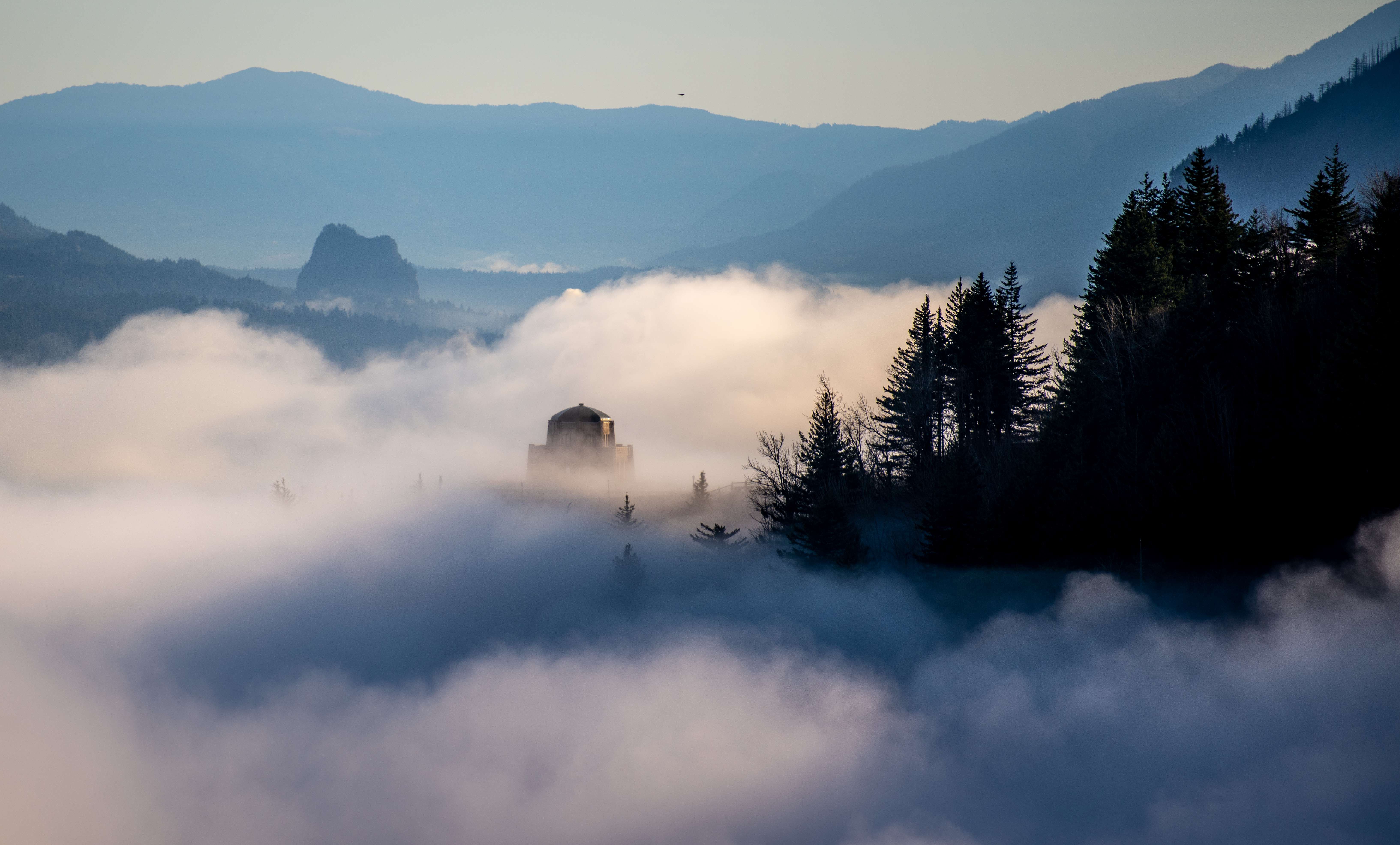
I can't remembr if I shared these vids and pics: http://youtu.be/-Zo6CBG5dTM http://youtu.be/GJe62vrrtFk http://weathercrazy.smugmug.com/Crown-Point-12414 Enjoy
-
Lol...they are part of the reason the winds were so strong! Very deep cold pool east side (but not deep enough to spill over the Cascades) and a very strong inversion. Just 400' above these winds, the winds were light and temps were in the mid 50s.
-
Talking with Matt Sloan, he's really into the wind/gradients/anemometers etc, he said there was a reported 148 mph back in the 60s or 70s? Other than that, this is the highest I've heard of being recorded.
-
This cyclist goes for a little ride, but not on his bike! Crown Point, Oregon. January 20th, 2014 http://youtu.be/RqWamgy9aJI
-
Great pics! Jealous!
