


whatitdo
-
Posts
146 -
Joined
-
Last visited
Posts posted by whatitdo
-
-
22 minutes ago, Stacsh said:
GRR's take on the storm. They feel models aren't handling it well?
Forecast reasoning: Powerful upper low off the Pacific Northwest
will serve as an upstream kicker for the cutoff low currently over
northwest Mexico. This cutoff low features 500 mb heights that are
very rare in terms of how low they are at such a southern latitude.
There is some indication that models are not initializing this
feature well, perhaps due to a combination of the low`s highly
anomalous nature and sub-optimal sampling of the atmosphere over NW
Mexico (due to a relative lack of aircraft measurements and POES
swaths). All of this suggests we could see an especially compact and
intense upper PV max approaching our area on New Years Day.

With such strong and relatively localized dynamical forcing
possible, we could see a wide variety of precipitation types and
intensities unfolding New Years Day into evening. Deterministic
models have recently shown a slight run to run cooling trend at
lower levels. The character of warm air aloft is also far from
certain. This has great bearing on precipitation type and tends to
feature a lot of forecast sensitivity to begin with, and that is
before introducing any possible dynamical cooling effects we might
see with the upper PV max.
@jaster220 thoughts on this upcoming system?
-
2 hours ago, Niko said:
As I have said numerous times, it might get stormy, but there is "NO ARCTIC AIR IN SIGHT." Tbh, I don't care about cold intrusions, as long as the storm track benefits my area. My average temps are now cold enough to support snow. Even slightly BN is even better (more powdery stuff). Highs in the 20s and lows in the teens is not considered brutal! I truly hope this changes and Arctic air does invade, don't get me wrong. I am just going w reality here and not wishful thinking. Also, I guess that is why I am successful.

That’s a fair point. Guess i should share ur optimism considering our average january temp is 30/15
-
 1
1
-
-
1 hour ago, westMJim said:
As of this morning (December 29th) here are some seasonal snow fall totals reported around part of Michigan. Of course, the first is Grand Rapids with 1.6” that is under 6% of where GR should be as of this date. In west Michigan Holland 3.8”, Muskegon 5.5”, Hastings 2.0″, Lansing 2.2″, Augusta 3.7″, Bloomingdale 4.8″, Big Rapids 5.7″, Fremont 9.3” Hart 14.8”. Even Detroit has reported 12.2” and to the south, South Bend has reported 14.9” Alpena 21.3″, S. Ste. Marie 26.6″, Marquette 52.6″, Calumet 52.0″, Herman 67.5″, Superior 63.1″ and Painesdale 63.3″
Many inland lakes in Michigan still have open water. The water temperature of Reeds Lake here in Grand Rapids Monday evening was 35°. Believe it or not, some of the Great Lakes buoys are still in the water. The north mid Lake Michigan buoy shows a water temp. of 43° and that is much warmer than average for late December.
With the insane warm up coming up with highs in the 40s for SWMI the lakes should be wide open for lake effect should cold air ever come down...only way to look at this in a glass half full kinda way
-
3
-
-
7 minutes ago, Stacsh said:
Long range looks super warm.
Warmest ive seen for a january map tbh
-
Just now, Stacsh said:
The surge of warm air and lack of any cold air is maddening. This could've been a major.
Too warm for anything substantial. Especially with temperature outlook looking very mild for January I fear w/o an SSW it’ll be much of the same at least for south michigan - despite the active pattern and being in middle of meteorological winter. Where is the cold?
-
1
-
-
9 hours ago, jaster220 said:
As expected. Too warm. We suck in warm winters. 2 months til spring, pls
sigh.
-
1
-
-
Just now, CentralNebWeather said:
@Clintonlooks like the Canadian does you no favors with the 2nd storm as it goes farther east. Hopefully the King is your friend.
got a map to share for michigan?
-
45 minutes ago, Clinton said:
If this verifies we are headed for a cold and snowy January.


Dont worry they never do lol
-
1
-
-
10 minutes ago, bud2380 said:
Canadian. More brewing with the second wave after this. This storm is crazy. Still no idea what to expect.

I don't buy this for SW michigan at this time frame - feel it will be a rainer till the 2nd wave rolls in and makes things interesting
-
 1
1
-
-
From meteorologist Mark Torregrosa for fellow Michiganders:
”Right now your time period of Thursday morning looks warm enough for rain from either of the two models we trust out that far. Definitely keep an eye on it with me and ask again Tuesday-ish. The time period in question would be Friday when it could get cold enough for some snow if the storm is still around. But Thursday morning is center in the warm flow. Looks like it could be 10-20 degrees warmer than normal Thursday morning. That would be hard to have any wintry precip. Hope this helps!”
-
1
-
-
From grand rapids NWS office: bolded explains why this is so uncertain
-- A range of impacts possible with a messy system Wed-Fri --
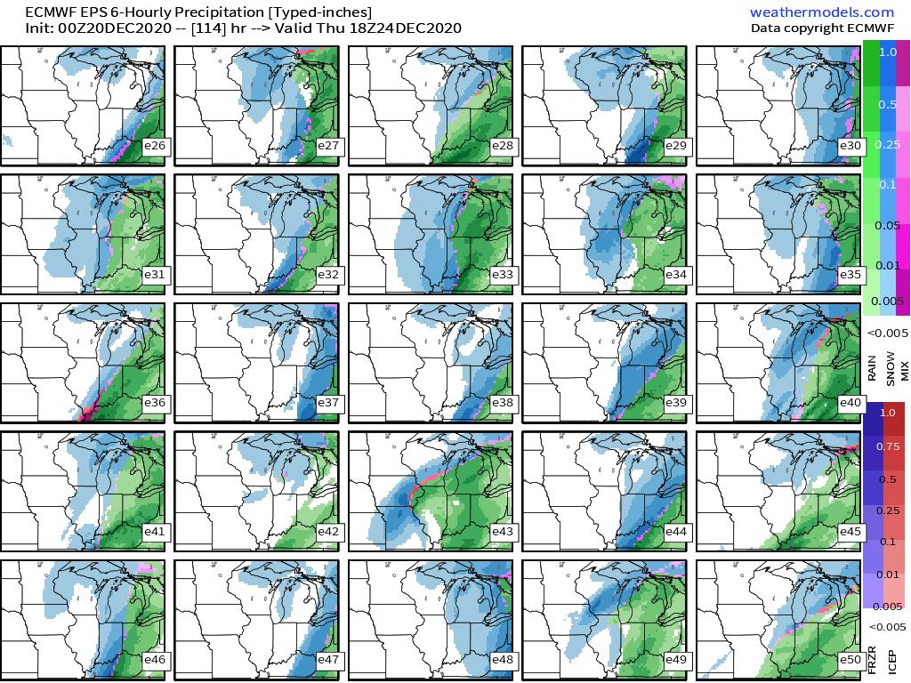
We are looking at an extended period of unsettled weather from Wednesday through Friday, with a good deal of uncertainty with regard to details at this time.
There is good agreement amongst the models and their ensembles that a fairly strong low will be taking shape to our SW as the southern and northern branches of the jet stream phase over the Plains. It looks likely that we will see a burst of some snow late Tuesday night and Wednesday morning as the warm front moves through. Then, we will see additional precipitation ahead of the system move in later on Wednesday and Wednesday night. This looks like it could transition through a wintry mix before changing all to rain as enough warm air moves overhead. The exact timing of this is still in question. The uncertainty begins on Thursday once the initial low and precipitation moves through.
The uncertainty exists as a result of the eastern progress of the front, and additional energy that will eventually ride up along the front. The final answer will be the result of multiple pieces of upper energy that eventually dictate the formation of the low, and the movement of the parts of it. There is no way at this time to pin down the details for Thursday and Friday with multiple pieces of energy, that are all over the Pacific Ocean and Arctic, that will all interact with each other. The general possibilities are that we could end up on the front side of the system, and have quite a bit more rain and develop some hydro issues. If the system is more progressive east, but close enough to affect us, we could see some accumulating snow. We could even end up out of the main precipitation. Wind also could be a factor.
It is something that bears watching, as different significant impacts will be possible with this energetic system.
-
2
-
 1
1
-
-
Got 2.5 inches here in kzoo. Was wonderful. Went out and caught a heavy lake effect band - first ever! Despite low totals so far, really couldn’t have asked for a better holiday season.
-
4
-
 2
2
-
-
12 minutes ago, jaster220 said:
Huh?? This hasn't even begun for Kzoo. I think the ULL that swipes SEMI may actually be slowing the timing up a bit from the NWS's earlier thinking. You should still do well when everything's a wrap.
Those in the Warning bullseye, ofc that's going to be sweet to wake up to. IWX going as high as 15"
* ADDITIONAL DETAILS...Areas along and west of a Holland to Paw
  Paw line, including I-196 will see the heaviest snow
  accumulations later this evening through Friday morning. 1 to 2
  inches per hour are likely under the bands, with some blowing
  and drifting snow expected to reduce visibilities to near zero
  at times.
Would be very pleased to have been wrong w that sentiment lol. But i was saying that based on nws changed description on snowfall accumulations for christmas day from 4 inches to 1 for whatever reason. When are the heaviest bands supposedly coming through?
-
6 hours ago, jaster220 said:
Nice. It should get a lot more interesting there overnight into Christmas morning for Santa! (and you too)

Hope it's still there but looking more and more like i won't see more than an inch or two out this thing. cant complain, best christmas weather ive ever had
") . The wait for the big one continues tho...
. The wait for the big one continues tho...
-
1 hour ago, Niko said:
This month doesn't seem to have arctic air as well going forward.
if there's no ssw i feel we may be in trouble
-
1 hour ago, jaster220 said:
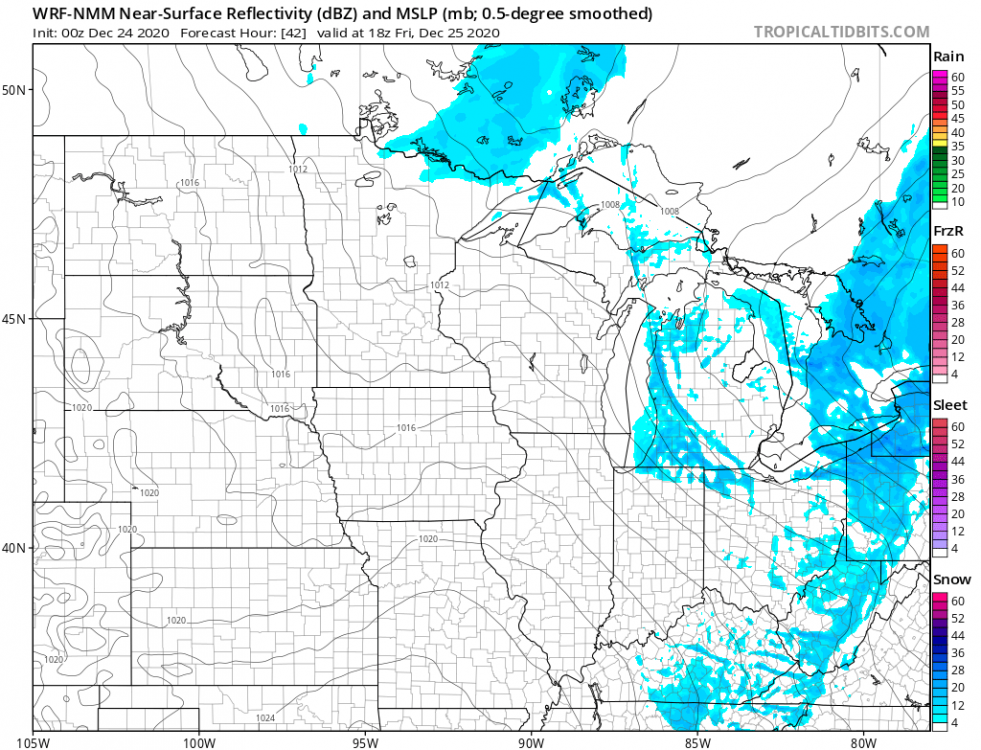
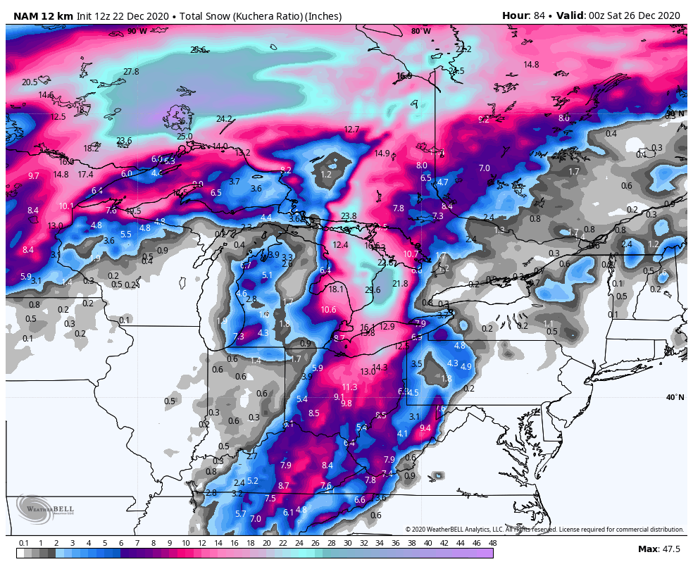
Prolly the ONLY one in the sub who cares to post (whatitdo? where are you??) on the remaining 3 days of this "storm" thd, but here goes. First map is the ultimate example of being in a screw zone sandwich that the models had trended to. Thankfully, some of the SR guidance has come back around to a (slightly) better outcome option here (2nd image) such as the NMM. GRR's map concurs, showing me back in the 1-2" total range (after saying yesterday, no accum's expected) here (last image). @Tom how does one put text in between images exactly?
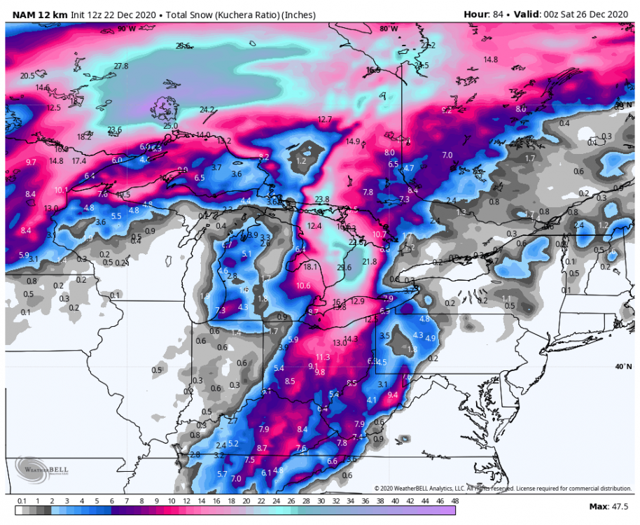

Here in kzoo we've had around 1/2 - 3/4 inch so far, gusty winds preventing accumulation. But I must say it's amazing just to see any white stuff floating around this time of year!
-
3
-
-
is there a reason his maps never show anything for west michigan or is that just how this map is?-
1
-
-
5 hours ago, Tom said:
00z Euro...as Bud said, not the biggest storm but it would deliver a White Christmas and transform the landscape into white gold for some of us. If we can somehow manage to get a few inches of snow and enough to cover the grass tips I'd be happy. The cold isn't as extreme as the models were showing in previous days but should be cold enough to keep the snow OTG for a few days.
00z EPS members are slowly shifting the west and trying to develop that southern wave as does the Euro control somewhat. I've seen dramatic changes inside 5 days in the models so lets sit back and see what changes likely will occur. This is a very complicated system and I don't think the models will handle the southern energy until its onshore.

@jaster220 @Stacsh why is the euro so hell bent on killing our vibes loool
-
4 minutes ago, Clinton said:
12z Euro Control

sigh. looks like euro's cutting back on the lake effect machine.
-
1
-
-
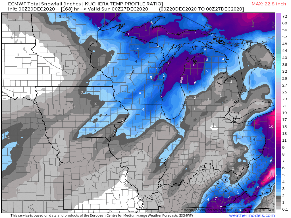
euro much warmer than gfs on incoming arctic air
-
59 minutes ago, Stacsh said:
Euro snow totals are light downwind of the lakes, but I'd have to think that set up would give WMI one heck of a LES event. Which models pick up LES the best? Usually don't see much of the models pick up on it in the long range, even with a great set up.
Also would like to know this!
-
1 hour ago, jaster220 said:
I do like the trends on that 500 mb map. Seems tho that south and east has been a theme this winter, which is taking things the wrong direction with the S. stream wave once again. Not set in stone yet ofc, but it's concerning to see already the "just misses me SE" being flashed.
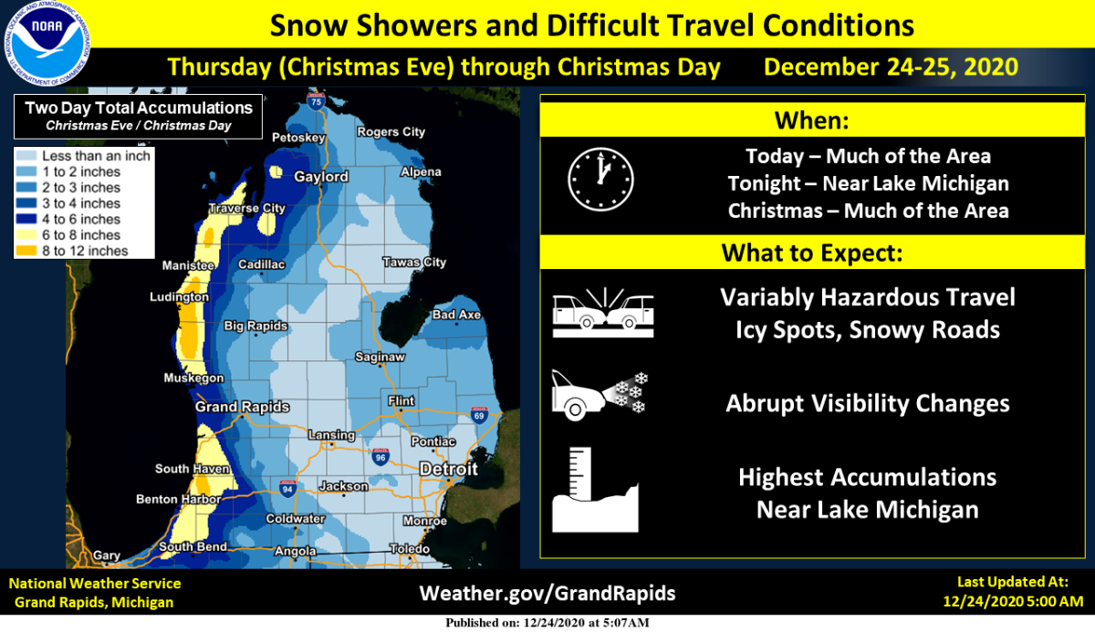
Yeah the misses SE have been brutal. Trusting these lows to track in the right direction isn't panning out - im hoping LES bails me out. Below is what NWS is thinking for my area. I have quite literally ~never~ experienced a white Christmas. It would truly be amazing if this came true, especially it being my first winter in the great lakes area, and I would have no problem disregarding the abysmal snow fall totals thus far if it came into fruition.
-- Lake Effect Snow Machine Cranks to Life into Christmas Eve --

The main show in the 7 day forecast is the plunge into Arctic air
and the threat for lake snows down wind of Lake Michigan. An
Arctic front will plow through the area Wednesday night (23rd into
the 24th). Models are still placing us on the warm side of the
system initially on Wednesday, so any synoptic snow swath looks to
miss us well to the north and west over Northern Wisconsin and the
Upper Peninsula. Lake effect snow looks to get cranking Wednesday
night, lasting through Christmas Eve and Christmas Day. 850mb
temperatures drop to around -20C. That will push delta T`s into
the extreme category in the middle 20s C. Loads of instability
obviously along with deeper moisture via the upper trough
overhead and shortwaves moving through to enhance lift. All
ingredients look to be coming together for some healthy lake
snows towards Lake Michigan. So, the entire area will not see
significant snows, but for areas along and west of Highway 131 its
looking more likely. Travel will be impacted given low
temperatures and accumulating snow. Later forecasts will provide
more details as we get closer to the event. GFS BUFKIT overviews
indicate a very healthy environment for lake effect snow. The
Northwest flow in place should keep things confined mainly west of
131. That said there is plenty of time for the models to shift
the flow a bit. Stay tuned...
-
1
-
-
2 hours ago, jaster220 said:
True dat. We rarely if ever make LES threads so you might as well use this one. I know it's your thing.
How likely is LES for the kalamazoo area? I was looking at the 850 temps and obviously some very cold air is coming in. Thought I heard somewhere the winds predicted to be NW. If i recall correctly from your LES post before we want a Tdelta 13-20 degrees? Whats it look like this time around - (i know this is still way early)?
-
36 minutes ago, westMJim said:
That information is from the NWS office.
you have a link by any chance? I'm on https://www.weather.gov/grr/ just don't know where to navigate from there

New Year’s Hard Cutter
in East of the Rockies
Posted
Yeah was gonna say confused as to why our office downplaying it haha