


OKwx2k4
-
Posts
5472 -
Joined
-
Last visited
-
Days Won
33
Posts posted by OKwx2k4
-
-
GFS showing merely a few hours of above average temps over the next 2 weeks down here.
I like it!
-
 1
1
-
 1
1
-
-
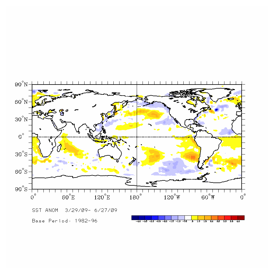
If there's still an old thread, after 3 Niña years in a row; out with the old, in with the new.
Today vs June 2009 (top analog)

The images are obviously from different sources, but in our hemisphere, hard to shake the similarities.
Discuss and enjoy!
-
2
-
-
2 hours ago, Andie said:
Gulf of Mexico water temperatures are warming up Hurricanes will be trying to form in a month.
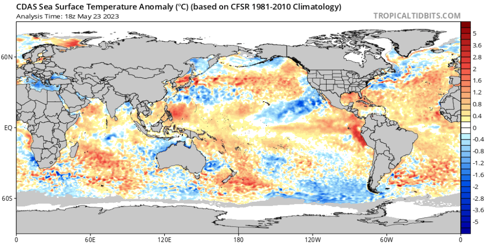
Current sea tmp: 27.5°C / 81.54444°F
Yeah. I get "Hurricane" by Band of Heathens stuck in my head around this time. Especially with famed mets echoing my thoughts now about interior Gulf hurricanes on the TX/LA border. It's going to be tremendously hard not to see a repeat of 2005 somewhere, I'm afraid, before it shifts back to the mid-Atlantic states and even points further in the New England states.
Again, i differ on total storms with 10-14 (below avg slightly) but bad ones will be a bigger percentage of that total.
Many things back me on this. El Nino being one. The tendency of the NAO/AO to hedge negative more often as we traverse summer being two major ones.
The Pacific is being dominated by lows off Alaska even in late spring is another telling sign. These all reinforce my ideas of a warm NE as well and rain returning to the Great Lakes region when the NAO relaxes and doesn't overwhelm the pattern so much.
Edit: this should probably be in the summer thread. Oops.
-
2
-
 1
1
-
-
On 4/11/2023 at 8:51 AM, Tom said:
Here was the Euro Weeklies run from yesterday...
I'm straight giving the euro an F for the month. I'm bailing on its seasonal, too.
They always get the Niño patterns wrong.
Polar opposites.
-
2
-
-
I basically agree with Lezak. I think the majors are going to be massively devastating.
I have a call for below average total but major impacts so, while i'll never fully agree with anyone, he's in the ballpark.
-
1
-
-
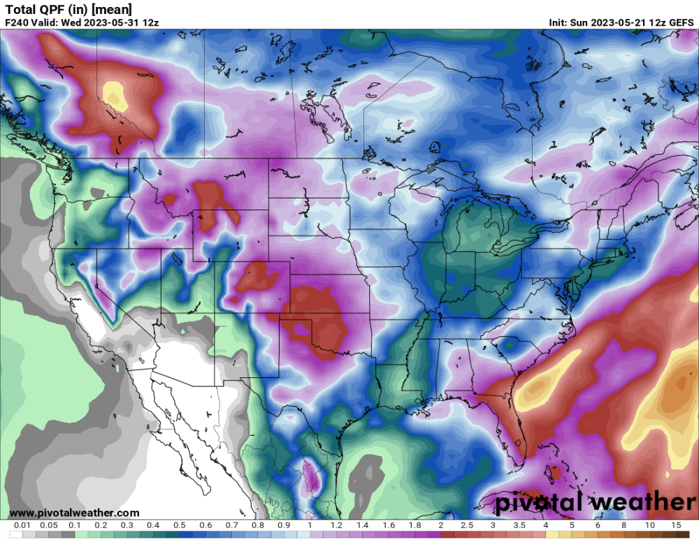
To the ones missing the rainfall, it will come. I'd bet on it. With this pattern in the NH developing, it is only a matter of time.
This pretty much nails my AO/NAO and Pacific calls for the remainder of this month and to close spring.
Sweet upper air pattern here.
Negatives are the added heat content in the GOM. Its going to produce a massive hurricane somewhere eventually.
-
2
-
-
1 hour ago, Clinton said:
Reed Timmer seems very confident the Southern Plains are about to have some severe weather over the next few weeks. Oklahoma looks to be the target.
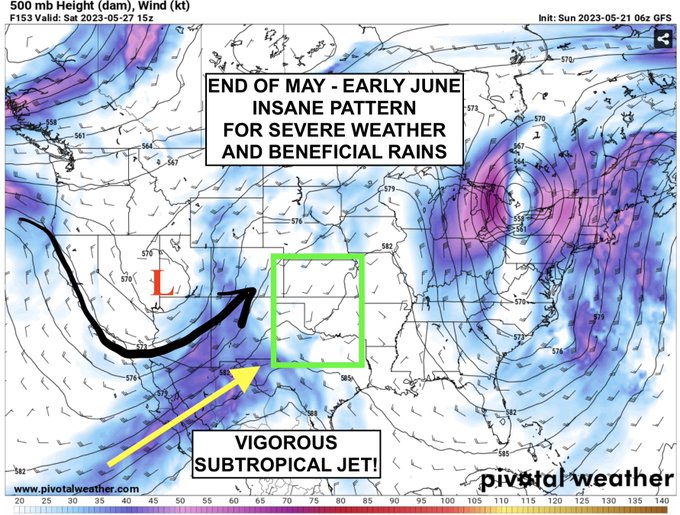
The end-of-May into early June pattern is as textbook new El Nino with remnant cold PDO/warm NPO from previous La Nina regime, one that favors day-after-day severe weather and beneficial rains for the southern Plains, including the southern High Plains. Storm season is just getting started. I typically hedge my analyses of long-range models with a solid foundational knowledge of the Pacific Climate System. Never stop chasingWe are eyeing next weekend to have two Dominators out in the field at once for the first time in 10 years. A lot needs to come together, but conversations are happening.Yeah, there's always another side to the good stuff. There will be amazing opportunities for severe weather, for sure. He covered the reasons pretty solidly about like I did in other posts. The Pacific is running the show from now through late summer or longer.
His terminology NPO is what I'm speaking of when I talk about the PDO/AO couplet.
This is the interesting part of this pattern.
-
3
-
-
Truly beautiful....
-
5
-
-
Just an fyi
Any longer-range modeling based off SSTs from the NMME is trash. Its basing off a siper-nino. May be why so many flood the US with heat all summer.
-
2 hours ago, Tom said:
It's finally going to dry out here as the DP's begin to fall today/tomorrow and a more normal MAY pattern begins with highs hovering around 100F all week, although, some signs that MDW may be a touch cooler than normal. I'm totally fine with that!
0z Euro...pretty cool animation showing a "squeeze play" where the Plains shall see precip and higher DP's while those west & east are dry.
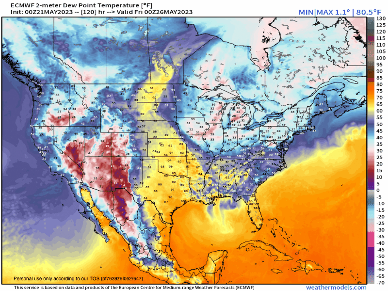
I'd be stoked to see a nice rally in the precip dept to finish off MAY...
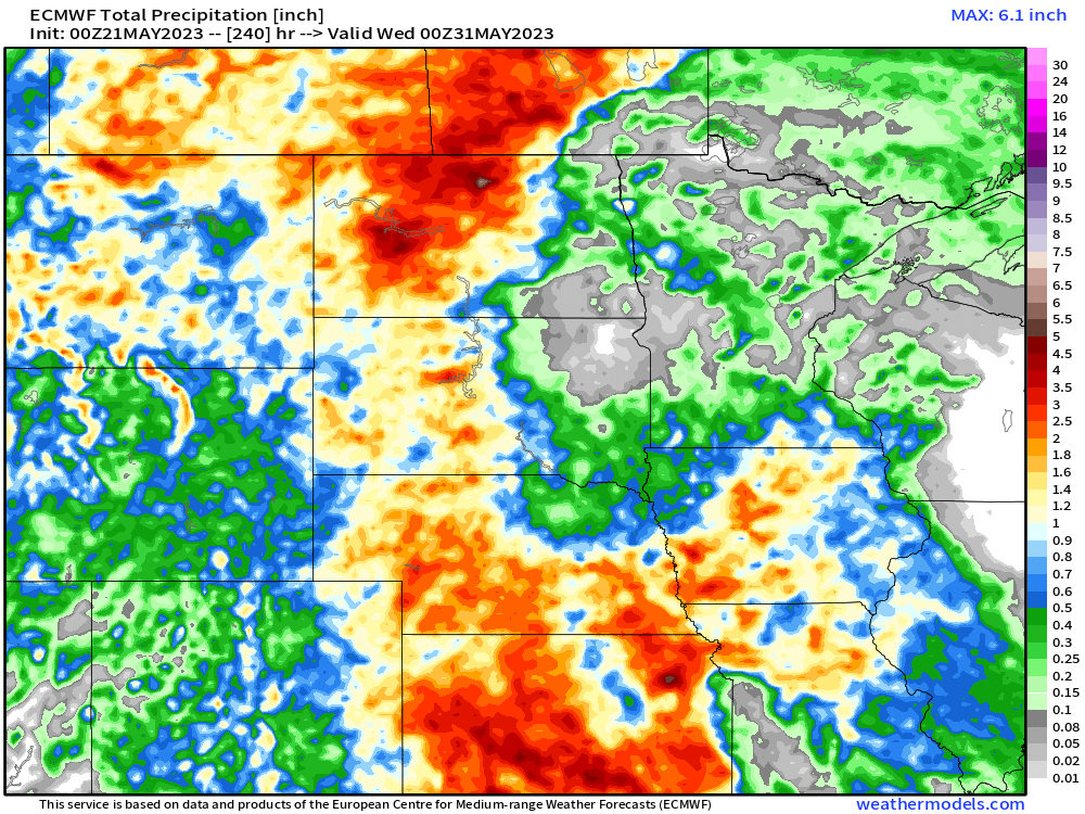
0z EPS...gotta love it when Nature targets those areas which need it most...
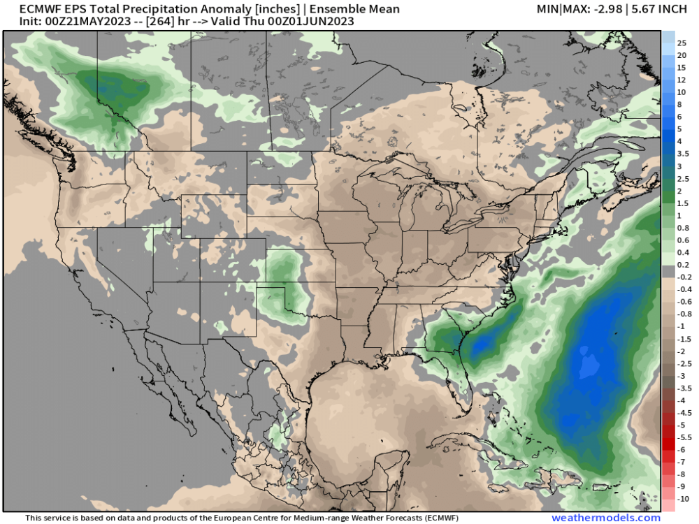

To the drought, we can call that one the "Plume of Doom". Like a life-giving heartbeat through the middle of our nation. Truly beautiful seeing everything change like that in cycle and in order. All in perfect time.
Your point in a previous post about hurricanes comes to mind there as well. I think its only a matter of time before we see it get rolling. While i wouldn't call for an above average tropical season for overall activity, I think when it comes, it will be a lot of mid-category or major hurricanes rather than high tropical waves and fish-storms as they used to be called.
-
4
-
-
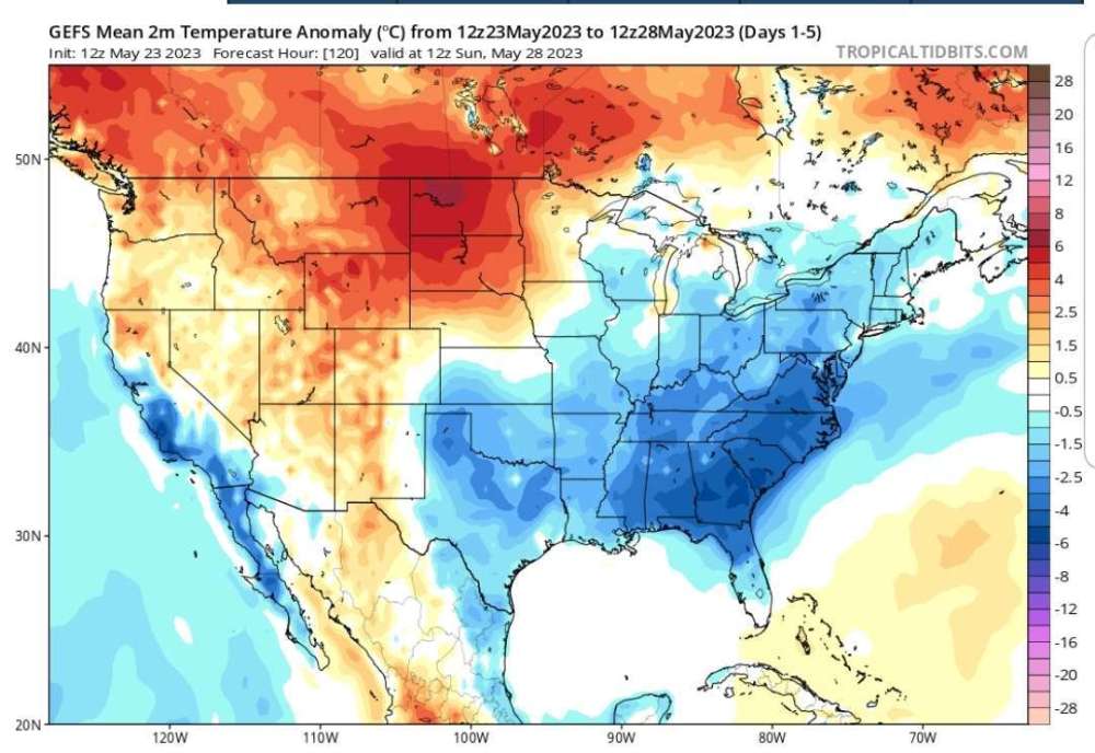
Getting pretty hard to hate the GFS trends with precip here in the south-central states. That's slowly squashing a future ridge there.
Other than a few warm spikes south and east of the OK/TX line, looking like the trend is cooler again for awhile on our end.
It makes sense to not see your typical flood of warm air we would usually see invading due to the westward shifted changing PDO in spite of a major spike in the NAO. Talking about blocking in warmer months may be a bit strange, but reasons are years like 2009 (I think) which saw major warm-season dips in AO/NAO couplet sort of define the core of summer weather.
Other factors at play as we close out May will be the development of typhoons over the west Pacific causing influence in the high latitudes as they recurve. There are a lot of sea surface temperature reasons for this that a more advanced meteorologist could explain better than I, but these are a lot of factors which, in my opinion, stack the deck against any major heat dominating anywhere in the heart of the nation for the summer. Maybe the very far northern plains into central Canada could close out summer above average along with the Northeast US.
That's a lot of my thoughts on what is coming and why.
I know some others may have a better handle on terminology than I do, so I apologize if I'm confusing. I welcome thoughts on it. I think it will be an interesting summer and possibly close to May.
-
3
-
-
2 hours ago, hawkstwelve said:
Pretty cloudy and chilly day today. High of only 54 which is good for a -18 departure from normal. Brrrr.
These slugs of cold damp air are still a bit much. Looks like you all get back to better weather pretty quickly though.
-
@Tom You gave me a pretty awesome westher history tool in that link. Its fun to get to look back at historical weather like that! Thank you.
-
1
-
-
8 hours ago, OttumwaSnomow said:
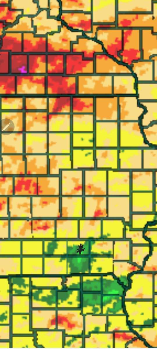
Record low May rain seems in the offing! While rest of Iowa says, Say what! Map of past 30 days. These kind of localized droughts are the worst. Like some one is picking on you! Happens way too often here.
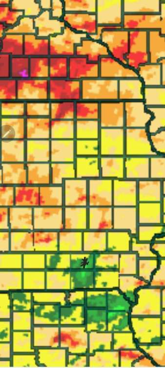
That's like me watching it snow in winter...EVERYWHERE else. Lol. Patchy or localized droughts are very weird and really unpredictable.
-
4
-
-
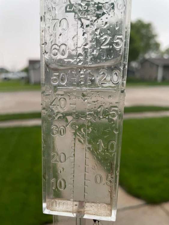
8 hours ago, Tom said:
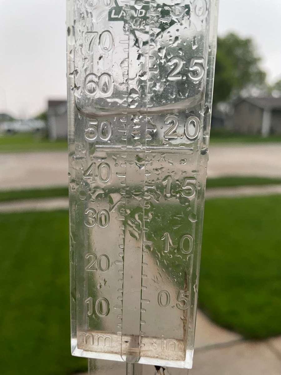
I picked up about 1.5 here. Mesonet shows around 1.2 inches, i think. Not bad. This has been the perfect spring for me so far with exception to the late freezes.
-
3
-
-
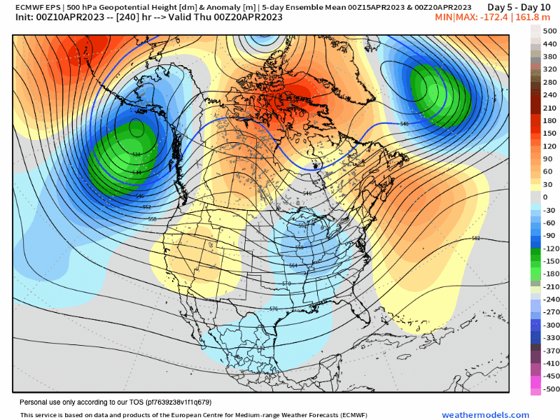
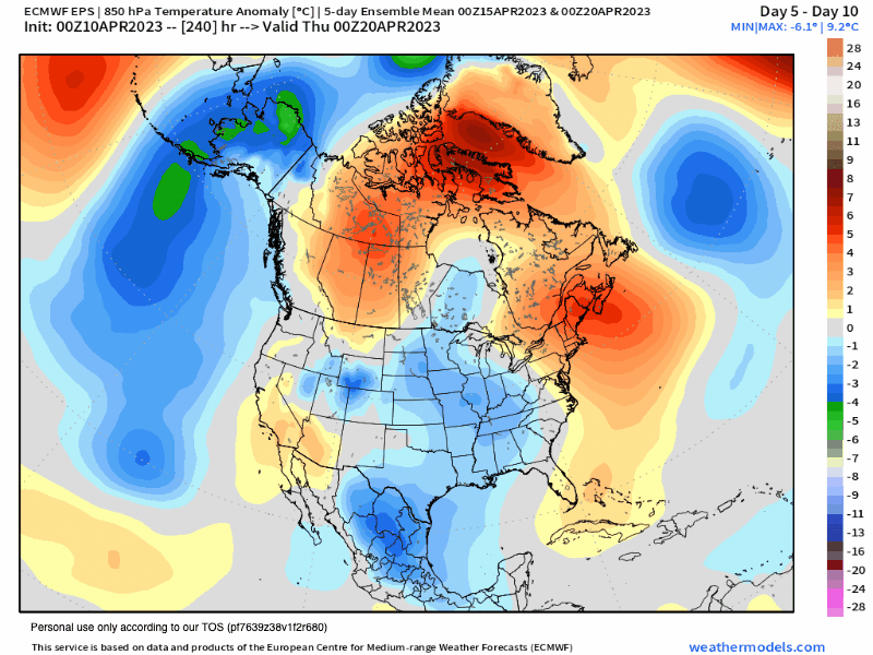
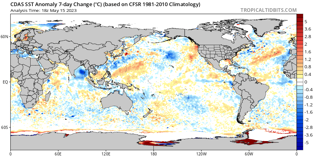
PDO ring going to start showing up on the west coast very soon.
If right on cue, going to reverse the warmth that tries to pop in the central CONUS in the later periods.
Year without a summer here (and much needed) is looking like a lock.
What will be exciting is to see if that eastern part crashes and leaves us with a central moderate or weak-mod east based Niño.
-
If these verify, going to be an awesome summer down here in the south-central states. No total drought-breaker, but hope beyond hope.
Its that connection across the south I have been talking of. Good stuff coming.
-
3
-
-
10 hours ago, hawkstwelve said:
We are heading into the season of having to deal with wildfire smoke.

Downside to Canada warming and drying while we cool and moist it up down here.
-
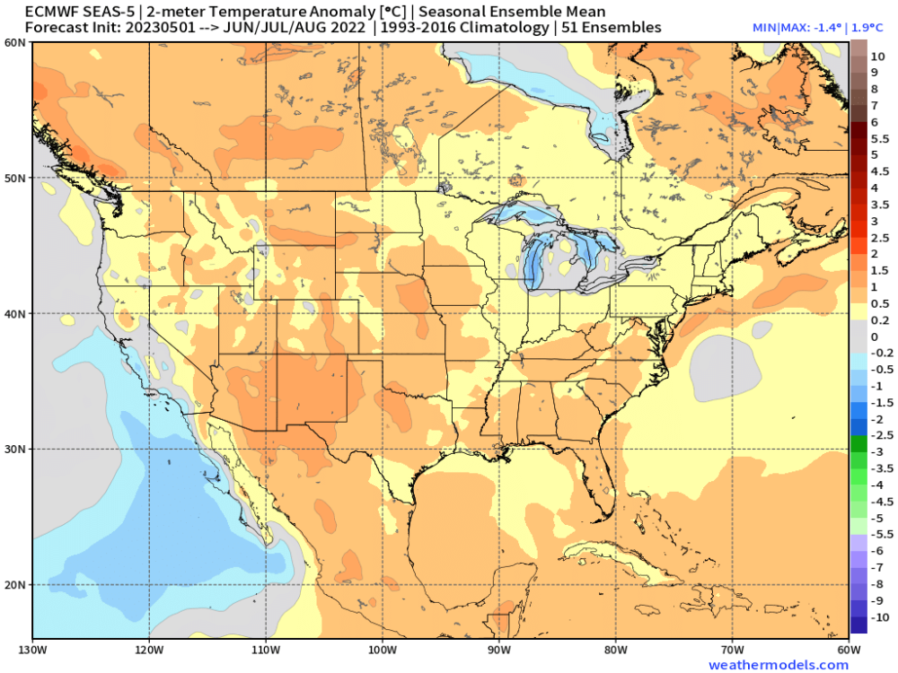
On 5/12/2023 at 6:57 AM, CentralNebWeather said:
Wonder how many millions this rain was worth? What a blessing it was. Gauge says about 2.20”.
That's a beautiful sight buddy! So glad to see that! Congrats.
-
Will be interesting to see what this "tropical punch" type storm out of the TX Gulf region does.
I know N TX needs the rainfall still, especially western areas.
Seeing this storm cycle through on models, along with the ensuing trough that ships it out of here is one of the reasons I have to agree with seasonal models indicating a cooler than average and shorter than average summer overall. When you see ridges get "attacked" by troughs like that, going to be hard to set up any large-scale heat domes like in years past. I think our northeastern cities and farthest north will struggle with most above average temperatures this summer. Mainly due to persistence but also likely still NAO/AO region influence being greater than old -enso/pdo ridging influences upstream.
-
2
-
-
11 hours ago, Tom said:
The Euro Seasonal came in this week and when I first glanced at it I said to myself "Who was it that said...Year without a Summer?" If anyone lives near the GL's, I'm concerned that "real summer" like we have had the past few seasons don't look likely this year. Nearly every global model is depicting a trough centered over this region and the MG ag belt. Cool Canadian air anyone??? As long as its sunny and you can enjoy those beautiful cool mornings and make a bon fire at night, it'll feel just right!
The Tropical threat down along the FL/SE coast is a concern and near TX..."GOM Trouble" is a high concern for cyclones this year. Higher than normal I'm afraid as the LRC had several systems that formed out of the Gulf region.
I don't necessarily agree with the dry signal for the 4 corners region...the CFSv2 has a better idea on a little wetter pattern...

"Year Without A Summer" guy would be me, Tom. Lol. This actually aligns very very well with my ideas going forward. The central ridge look in place now being transient, with an eventual anchor-point southwest as summer goes.
The ENSO/PDO/Arctic domains are critical for the next 3 months.
What may ultimately set up is a compromise, though. Resulting in persistence in the "dust bowl" region already experiencing drought conditions. It really depends largely on how fast the pac jet gets rolling later in the season, imo.
-
2
-
-
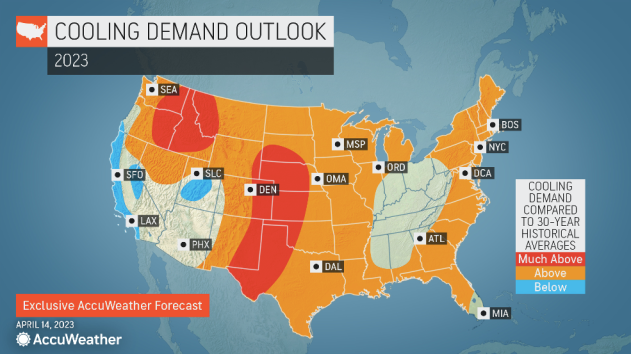
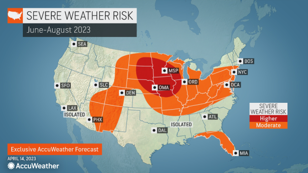
16 hours ago, Tom said:
Accuweather's take is a lot different and expects more Heat than Cool across the Heartland...I am in agreement of the active Wx across the MW/Upper MW. I much anticipate to see "Ridge Rider's" and what could turn out to be a big season for long duration Derecho's.
I'm hoping that there is plenty of drought busting action this late spring and summer where it is needed badly. Farmers need some great seasons after the last few years.
Also, I kind of fall in the camp of seeing the ridge shift south and west with time as summer rolls by. There's the very real possibility I'm seeing bias due to shoulder season patterns, which I'm notoriously bad at. Lol.
The developing Niño with it's far east base is affecting weather in the tropics already and in TX/OKs sudden transformation to a wetter pattern over the next 2 weeks. It's in direct conflict with a cold pdo signature so will be neat to see it all play out. If the pdo can flip fast enough to positive, my logic says the early central CONUS ridges will shift westward. It may very well never fully shift warm at all, too.
Interesting weather ahead. I like it.
-
I'm probably running 3/1 colder than avg vs warmer than average days for April.
As Tom was writing about our pattern going forward, I agree with him on most stuff to come. I don't foresee having much extreme heat east of AZ or the Rockies this year with exception to hard drought areas. Going to be a short summer if the ridges connect in later months.
Another thing, its odd to see these patterns in peak solar, which will be bombarding our atmosphere pretty heavily from now to end of 2024 if the new predictions are right.
-
2
-
-
Looking at a low here in eastern Oklahoma of 34 in the morning. Going to feel that one after the last few days.
-
 1
1
-


ENSO 2023
in East of the Rockies
Posted
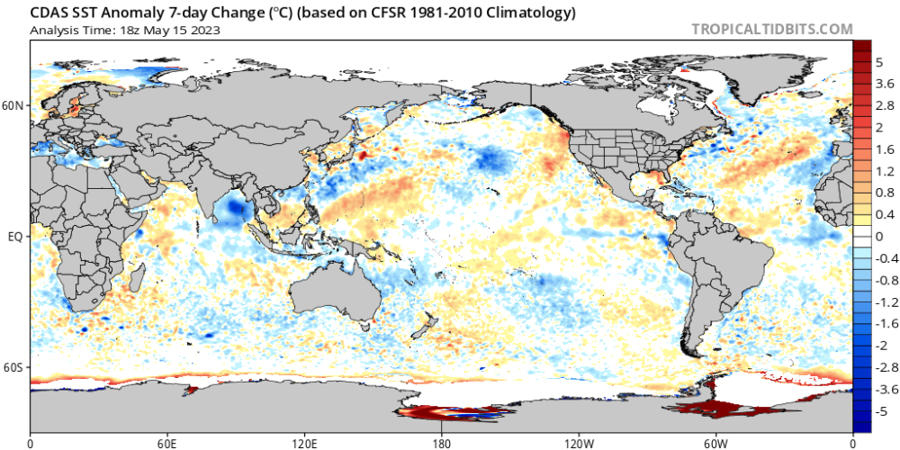
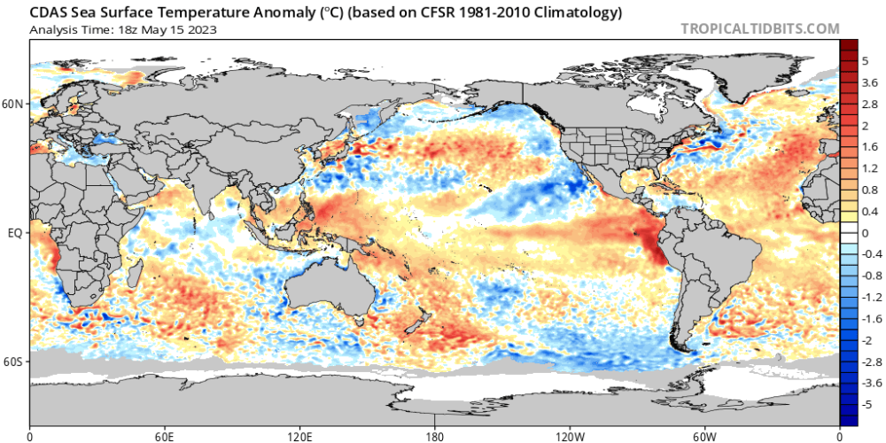
Yep. Keep that cold tongue in the east (straight north of 1.2) and north of the ENSO region all the way up to Baja California and i'll need a snowmobile for a month at least. Subsurface backs this and atmosphere agrees as well. All the heat is stacked on the other side of the globe.
I LOVE this. I've been trying not to say the winter word here, but...well, oops. Haha.
Tom, I blame you. You started it! Lol.
I'm excited for the summer AND the winter to come.
My honest thoughts are actually that the CFS has the Niño too far east even there. May have one centered very close to 180 line with no Pacific-induced warm masses of air flooding us.
I was early last winter. This one is going to be the big one. I scored avg snow last season with really not ever the best conditions to do it in. Won't be that way this year, in my opinion.