


Outpost54
-
Posts
155 -
Joined
-
Last visited
Everything posted by Outpost54
-
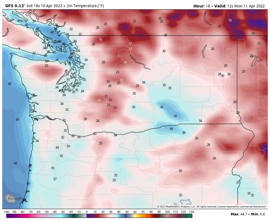
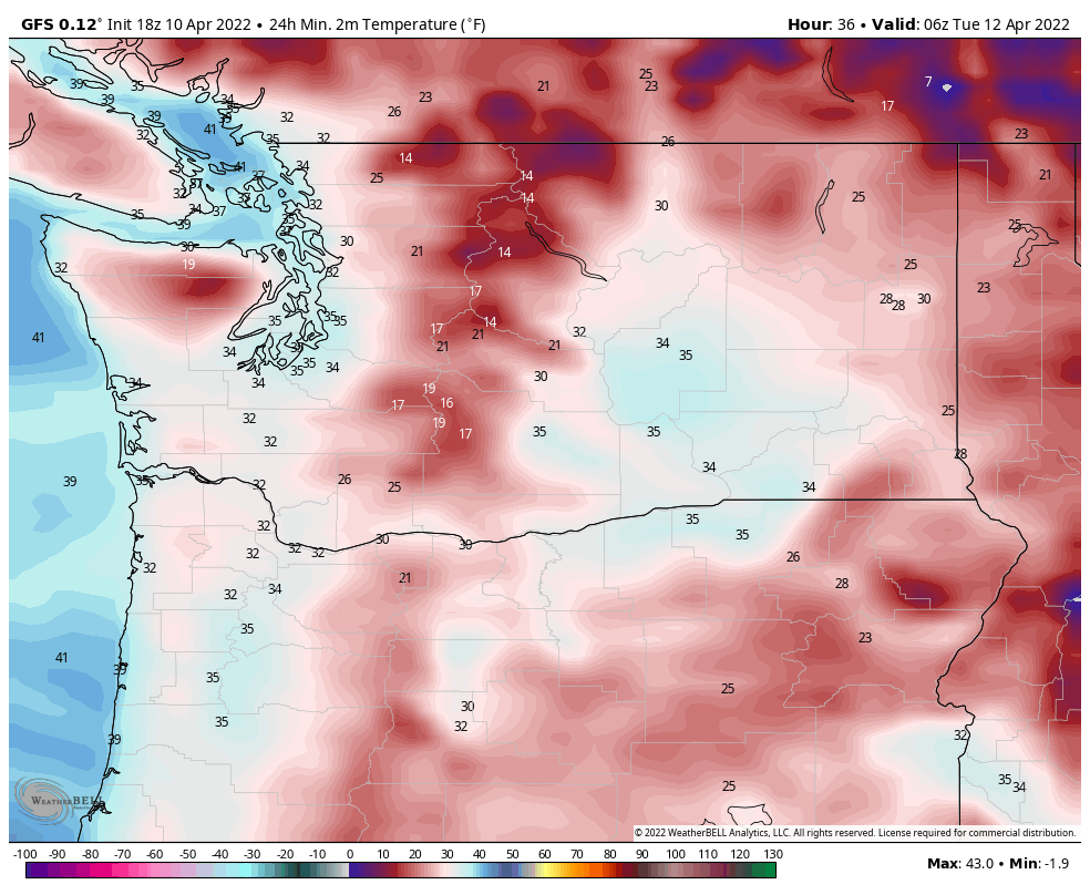
Also, that's just the 24 hour low ending on that period. It's not Monday night at 11pm, necessarily. It does show it being 32 during prime time on Monday morning. This is 5am Monday.
-
You're over.
-
Another noteworthy change here is that the GFS now shows most of the Portland area just kissing the freezing mark while all this snow is falling. Previously it had been putting up all these crazy snowfall amounts with temperatures in the mid 30s. This is significant as it makes the idea of heavy accumulations much more plausible if it is actually 32 degrees while this is happening.

-
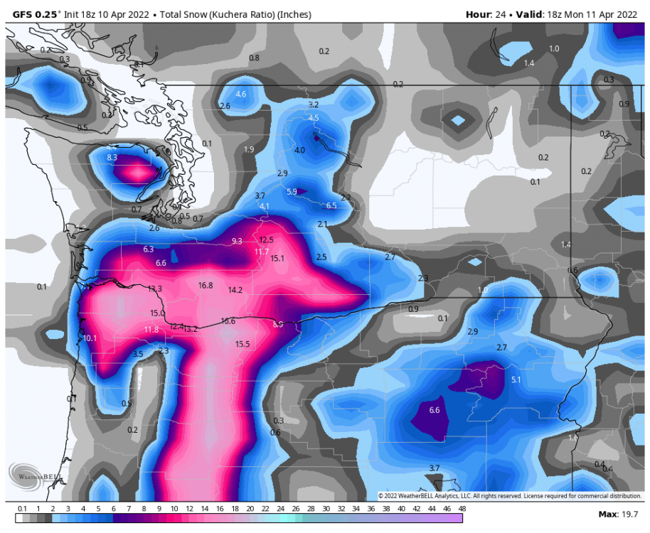
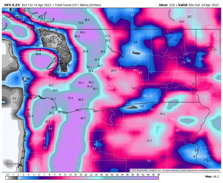
Even the kuchera ratio on the 18z GFS has over a foot at PDX by tomorrow morning. What the hell lmfao
-
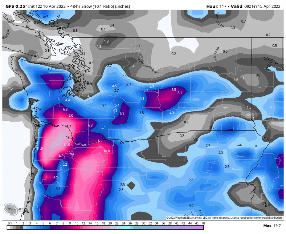
Also I've seen some mention of the cold on Thursday, but I feel like we've been overlooking the growing snow threat over that period, too. This map is literally just for Wednesday and Thursday. Doesn't include anything that falls tonight into tomorrow. Would be historic.
-
How long do u guys thing Portland will have snow cover from this???? Until May or so?????
-
Canadians being nice to Portland as well
-
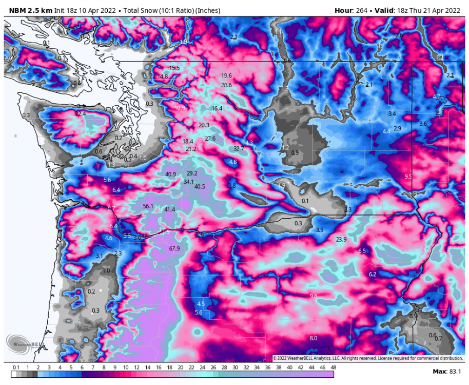
18z NBM is excellent for Portland. This is typically the most conservative model output you're ever going to find, too, given its nature. This had been showing 0 snow around Portland until today's runs.
-
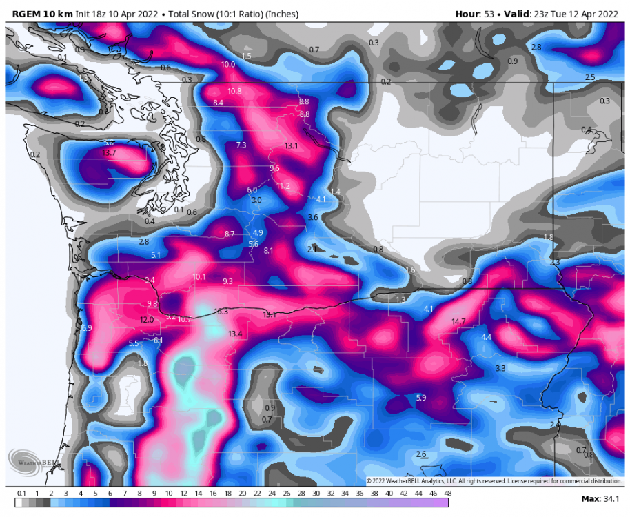
Yes this is 10:1, but what the actual ****?
- 4519 replies
-
- 11
-

-

-

-

-

-

-

-
Euro confirmed yummy for Portland.
.thumb.png.04c73bf928a5c00317d205da26536273.png)
-
Looks like it's sticking to it. This run will be yummy for Portland
-
And even the 3km NAM is shitting pepto out in the lowlands. This one is a bummer for Portland, but it absolutely buries some areas between Centralia and Olympia, and shows a nice little strip of blue in North King County/South Snohomish County. Regardless of where it is, it is absolutely insane to see pepto colors in the lowlands, within 72 hours, in mid April.
.thumb.png.a87774f172af3bd7a5707bd5d684e796.png)
-
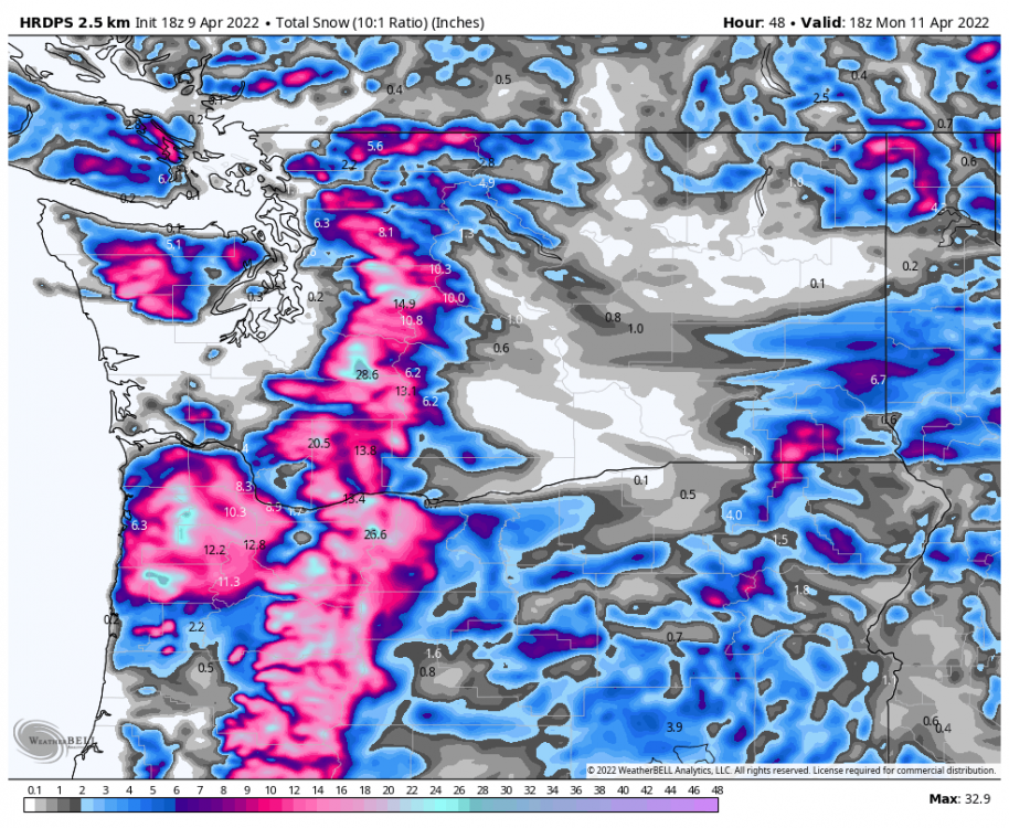
HRDPS is pretty crazy for Portland. This is all within the next 48 hours.
-
What about that rat **** dabears?
-
PNW November 2021 Wx Obs/Discussion
Outpost54 replied to Meatyorologist's topic in West of the Rockies
Holy , I don't think I've been more excited to see the final frame of the Euro. Day 10 is gonna be absurd. -
PNW November 2021 Wx Obs/Discussion
Outpost54 replied to Meatyorologist's topic in West of the Rockies
Now that the GFS has pulled back a bit, watch the 00z Euro flip and start showing major snow this weekend/early next week. I've got a weird feeling about this run, lol. -
PNW November 2021 Wx Obs/Discussion
Outpost54 replied to Meatyorologist's topic in West of the Rockies
Interesting chart, but this might be comparing apples to oranges somewhat. I would agree that the Euro is still more accurate in the 5-day range. I'm referring more to its ability to detect significant pattern changes in the long range. Anecdotally, it seems to me that ever since the upgrade, the GFS has picked up on the gist of major events significantly earlier than the Euro, but then it still struggles with the details. The Euro on the other hand has seemed slower to detect major pattern changes, but then once it finally does catch on to what the GFS had already been showing for a few days, it nails down the details much better. Like with the heat wave for example, I remember the GFS was showing 120+ at PDX for several days before the Euro got on board with even breaking 100. But then once the Euro finally recognized that a major event was coming, it remained pretty firm that PDX would only top out around 115, which was what actually happened. Meanwhile the GFS kept spitting out 120+ degree insanity pretty much all the way up until the event actually happened. Just my purely anecdotal perception though, I admit I could be totally off base here if the data says otherwise. I'd be curious to see a chart like this for the 10 day mark, if it exists. I bet the new GFS beats the Euro there. -
PNW November 2021 Wx Obs/Discussion
Outpost54 replied to Meatyorologist's topic in West of the Rockies
Tbh I think people are under estimating the new GFS. Don't forget it was upgraded like a year ago. Ever since then, it has pretty clearly led the way with almost every "extreme" event we've had in the last year, while the Euro has played catch-up. Remember the GFS picked up on our absurd heat wave first, and the big snow storm in February. I don't think it's totally insane anymore to give the GFS more credit than the euro in cases like this. The new upgrade seems to be a genuine Improvement. -
PNW November 2021 Wx Obs/Discussion
Outpost54 replied to Meatyorologist's topic in West of the Rockies
You realize that significantly more people die every year from cold than from heat? This cheering for snow and cold is absolutely ******* vile and honestly straight up psychopathic. You all are wishing for people to DIE. -
PNW November 2021 Wx Obs/Discussion
Outpost54 replied to Meatyorologist's topic in West of the Rockies
Stop posting Oregon only maps. No one ******* cares. The WA map covers 99% of this forum's members, but the ones you keep posting cut out half of them for no reason. I'm so glad you never get snow. You are subhuman scum. -
Those are lenticular clouds! It's the same type of cloud as whenever you see Mt Rainier or Mt Baker with what looks like a "hat" on top. These form as a result of wind moving over mountains, however it's extremely rare to see them on the relatively low parts of the Cascades like in your pictures. I saw some pictures from the same day of some lenticular clouds over the Olympics, which is similarly rare, but I hadn't seen any from this section of the Cascades yet. Very nice capture! Definitely save these pics, because it could be years before you ever see that again here.


.png.07ac950ec4e2c099184b3123aa627c1c.png)
.png.026b04c987bbe217556fc3395e2f6850.png)


