NWbyNW
-
Posts
1502 -
Joined
-
Last visited
-
Days Won
2
Everything posted by NWbyNW
-

2022-2023 California and Southwest Weather Thread
NWbyNW replied to Thunder98's topic in West of the Rockies
Some rain coming, lots of lightning activity today. More snow for the Sierra's.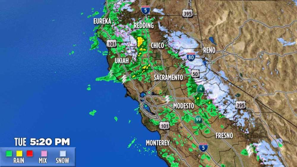
-
2022-2023 California and Southwest Weather Thread
NWbyNW replied to Thunder98's topic in West of the Rockies
The rain comes again later today but it's moving back to the northern part of the state. Strong gusts expected again. There were actually two tornado warnings around Modesto and Stockton (I may be wrong, I saw it in passing). I can't check right now since I am not able to. Highway 101 near Gilroy.
-
PNW January 2023 Observations and Discussion
NWbyNW replied to Requiem's topic in West of the Rockies
Here's a tiny bit bigger map. Some of the totals are crazy for a 24hr period.
-
2022-2023 California and Southwest Weather Thread
NWbyNW replied to Thunder98's topic in West of the Rockies
I was watching a news channel in Sacramento and they showed video of Highway 101, where a portion was a running stream of water and debris and trapping cars. NWS Monterey posted some good informative graphs and what not. Don't forget more rain and strong winds tonight for Northern California tonight. The rain and snow will be in Central/Southern California tonight. Rolling into LA, Santa Barbara, Bakersfield, etc. San Diego is again getting out of another storm with practically no hit.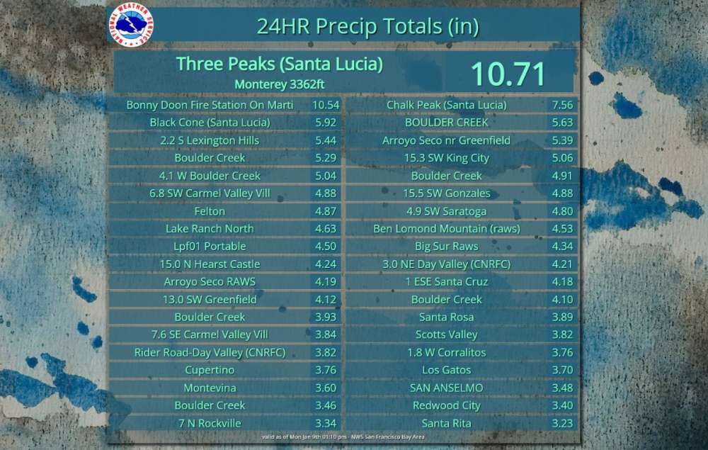
-
PNW January 2023 Observations and Discussion
NWbyNW replied to Requiem's topic in West of the Rockies
Absolutely pouring here. Coming down fast and furious. Looking at radar, some impressive heavy spots especially east of the Olympics, then onward to Seattle. No rainshadow today! This heaviest bit is now over Snohomish and King Counties!

-
PNW January 2023 Observations and Discussion
NWbyNW replied to Requiem's topic in West of the Rockies
Plenty of opportunity for some silly weather. Just waiting for the forecast to include some sporadic gusts, random hail, snow, heck, some lightning, lol.
-
PNW January 2023 Observations and Discussion
NWbyNW replied to Requiem's topic in West of the Rockies
Woah! That's pretty wild. It hailed here for about 10 seconds. I heard a few hit the skylight, looked up, and it hailed, then stopped within seconds. -
PNW January 2023 Observations and Discussion
NWbyNW replied to Requiem's topic in West of the Rockies
Hehehe, you're gonna laugh. It's my fav too. Link -
2022-2023 California and Southwest Weather Thread
NWbyNW replied to Thunder98's topic in West of the Rockies
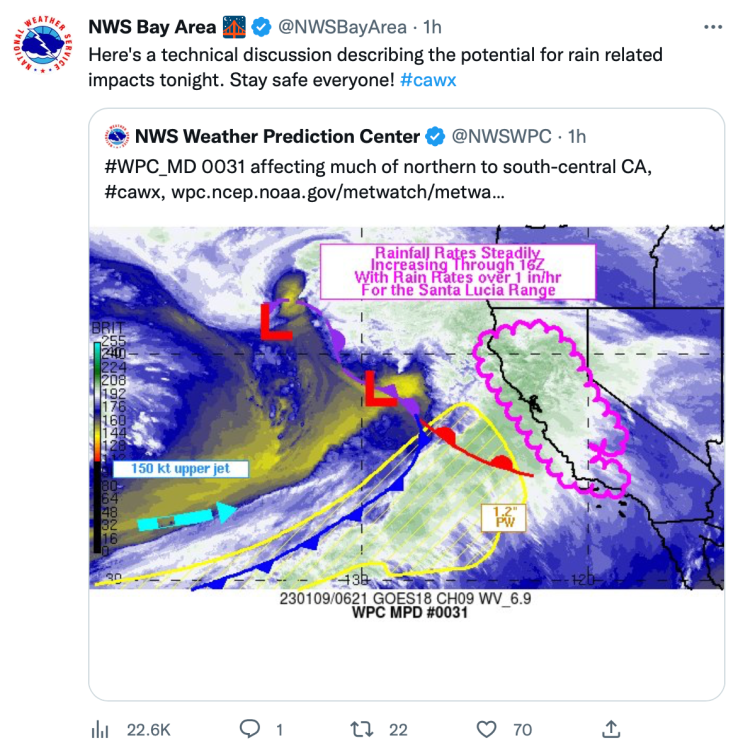
Had to show this. You can see that STREAM of moisture just driving into California. Very prominent.
-
PNW January 2023 Observations and Discussion
NWbyNW replied to Requiem's topic in West of the Rockies
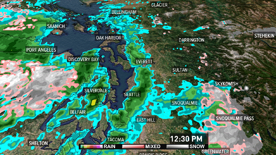
The rain really hit suddenly. Very heavy bits over Seattle and uhh... Saanich.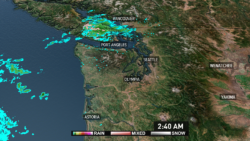
-
PNW January 2023 Observations and Discussion
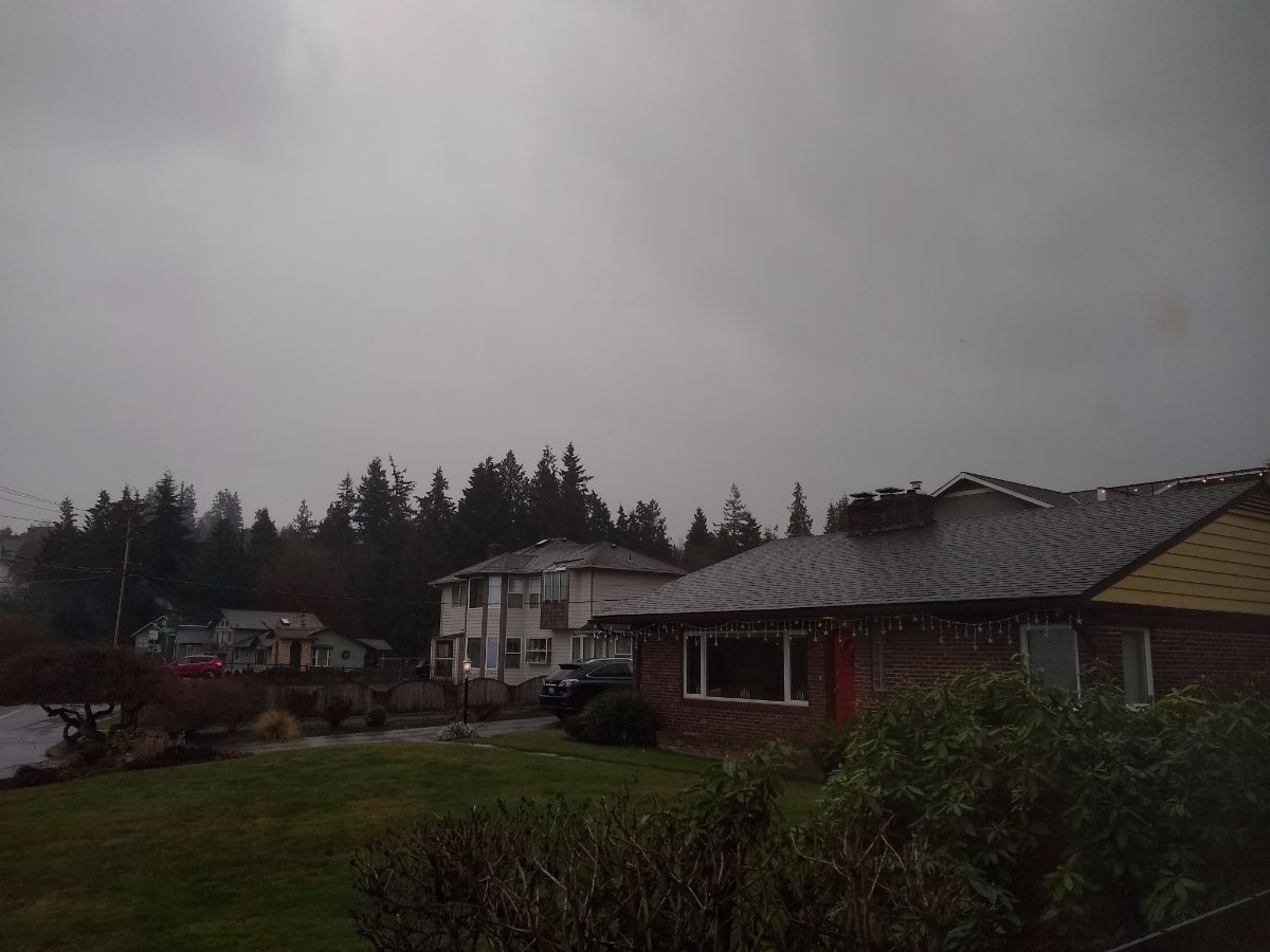
NWbyNW replied to Requiem's topic in West of the Rockies
For being 2:41pm in the afternoon, it is incredibly dark outside here. Camera doesn't do it justice. People are driving with their headlights on and automatic street lights have turned on in places. Raining outside and 51F.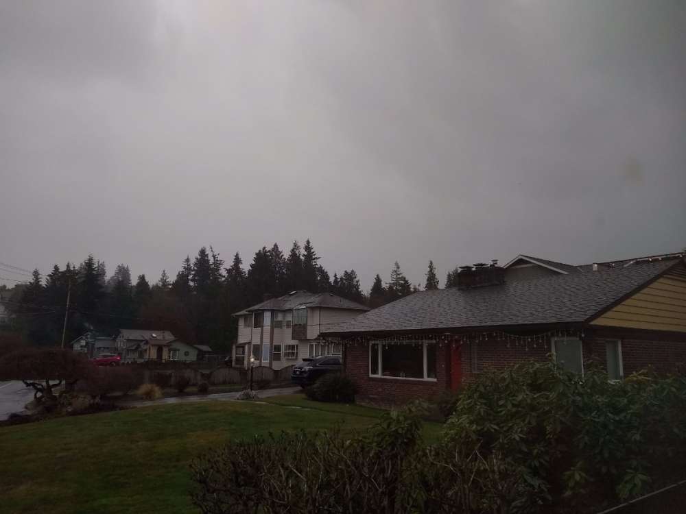
-
2022-2023 California and Southwest Weather Thread
NWbyNW replied to Thunder98's topic in West of the Rockies
Welcome to the community! So glad we got some new blood in here to hopefully liven things up! I've been trying, and we got some dedicated folks here, but most just care about their block they live on and that's about it. lol. Sorry about your fence, that does indeed stink. Looking forward to having you aboard! -
2022-2023 California and Southwest Weather Thread
NWbyNW replied to Thunder98's topic in West of the Rockies
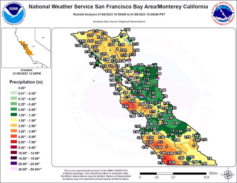
Most of the precipitation has moved south from its initial contact zone last night. Lot's of rain still. Lot's of flooding in Northern California. Here is the latest satellite image from about ten minutes ago.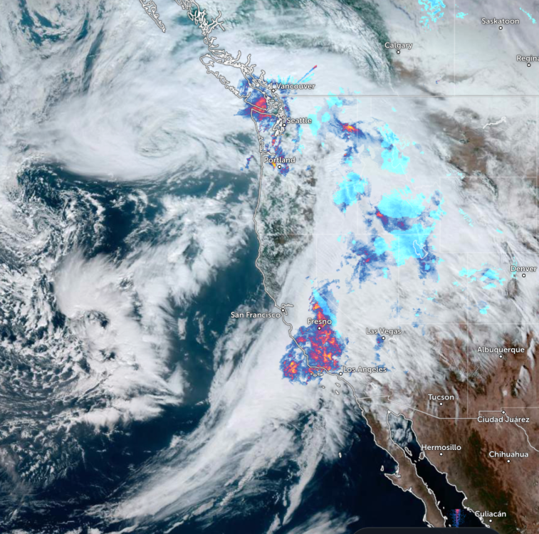
-
PNW January 2023 Observations and Discussion
NWbyNW replied to Requiem's topic in West of the Rockies
Raining on Monday moooorrrrnin'.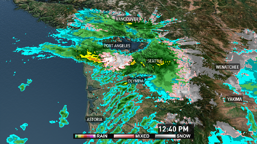
-
2022-2023 California and Southwest Weather Thread
NWbyNW replied to Thunder98's topic in West of the Rockies
Warnings you all already know. Strong wind gusts and heavy rain. Be safe out there. First storm of many this week. Wind gusts. Preciptation.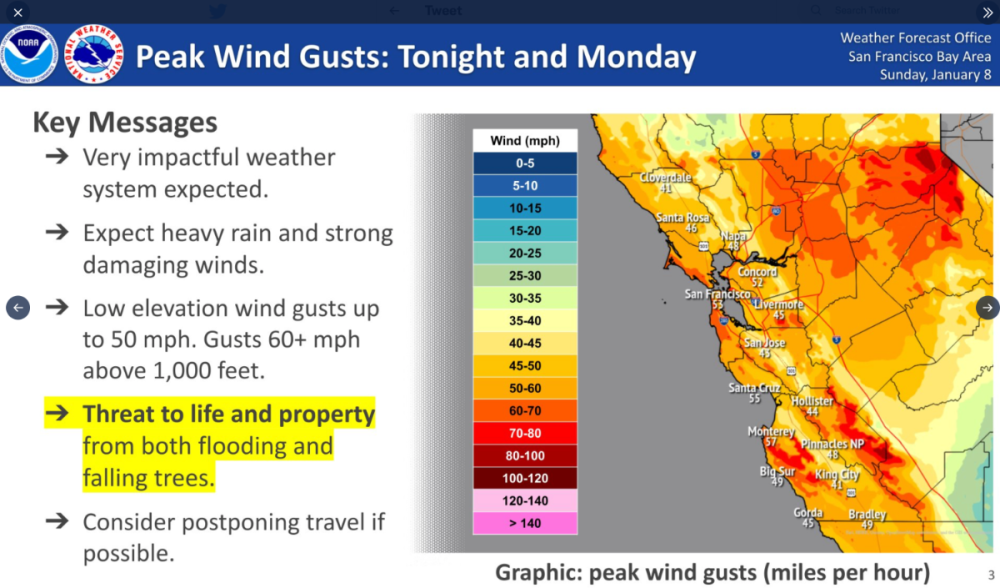
-
2022-2023 California and Southwest Weather Thread
NWbyNW replied to Thunder98's topic in West of the Rockies
Here is comes.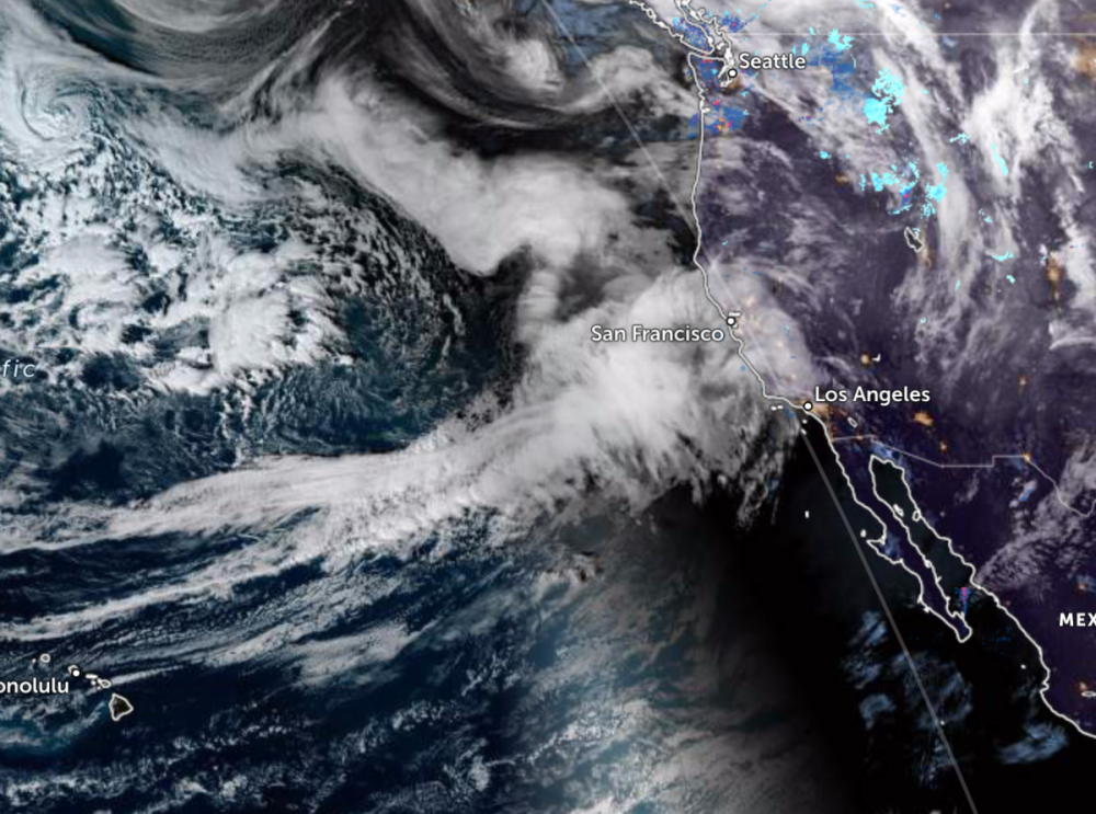
-
2022-2023 California and Southwest Weather Thread
NWbyNW replied to Thunder98's topic in West of the Rockies
Keep this in check and let's compare it to after this latest grouping of storms hit. The numbers have been updated and include the rain storm from last Thursday now and overall, it's great seeing the numbers go up significantly in some cases! Since Jan 5 to Jan 7, the totals have changed to... Shasta from 35% to 37%. Sonoma 36% to 40%. Oroville 41% to 43%. Folsom's went down because they actually let water out. I don't know the reasoning for that... Maybe a flooding issue? etc, etc...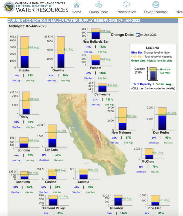
-
2022-2023 California and Southwest Weather Thread
NWbyNW replied to Thunder98's topic in West of the Rockies
I didn't even think about looking, but the wind storm last night saw 40-60mph winds. A 68mph was the high I could find north of Sacramento. It knocked out power to over 300,000 people in the valley. Sacramento County, San Joaquin, and Yolo Counties make up the brunt of the outages. Still 324,000 without power in Northern California and the big storm hasn't even hit yet. That comes in tonight. Oh my gosh, this could be days without power for some, not to mention the upcoming flooding. My word. -
2022-2023 California and Southwest Weather Thread
NWbyNW replied to Thunder98's topic in West of the Rockies
Last day to prepare before the never-ending California deluge begins. -
PNW January 2023 Observations and Discussion
NWbyNW replied to Requiem's topic in West of the Rockies
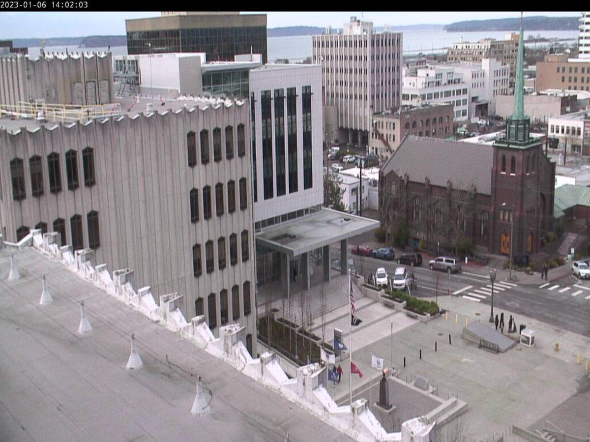
50F degrees here in Everett. Some lights showers during the midmorning and around noon, but over wise, a nice day. Cloudy, with some dark colored clouds towards the Cascades. Live view from moments ago, people are out and about on this Friday afternoon!!!
-
2022-2023 California and Southwest Weather Thread
NWbyNW replied to Thunder98's topic in West of the Rockies
Wow, the latest update Jan 5, has increased totals a lot since the previous days recordings. Shasta went up from 34% to 35%. Oroville up from 39% t0 41%!!! Wow! That's just one good dousing. Millerton up to 79%, one full percentage point up. Sonoma from 33% to 36%!!! Good to see this.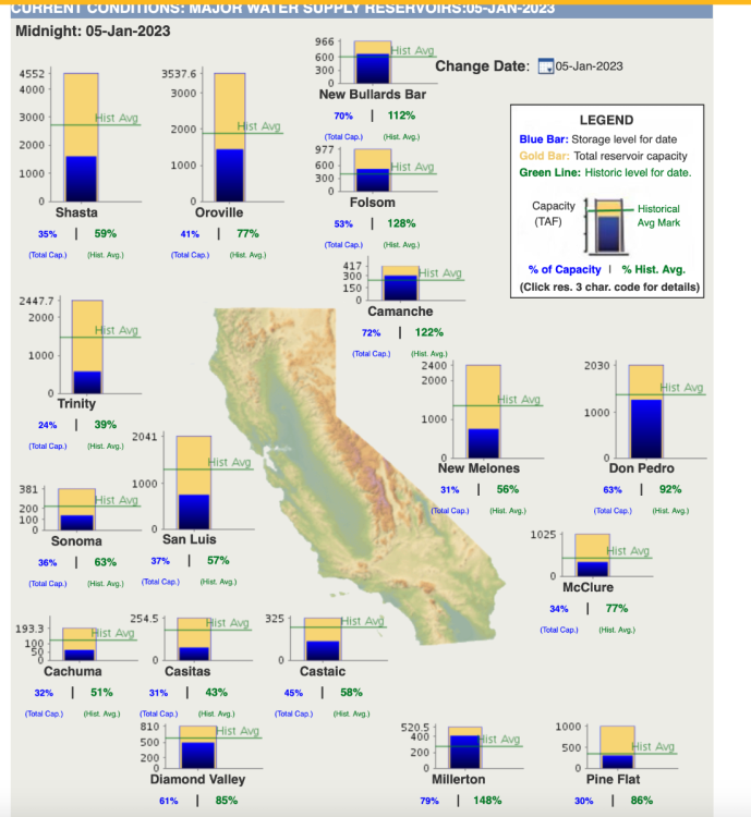
-
2022-2023 California and Southwest Weather Thread
NWbyNW replied to Thunder98's topic in West of the Rockies
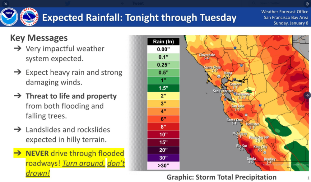
Northern California has until Monday morning to prepare for the next stronger storm to arrive. This next one is going to cause massive flooding from the Bay Area northward and all through the valley. 30-40mph winds are expected, coming from the south and west as it blows northward. Upwards of 5 inches of rain is expected for this next Monday storm. I hope people are prepping now. It will also rain this weekend throughout region, but not as much compared to the other day or what's coming Monday. Tons of snow expected in the Sierra's too. Prepare!! Very heavy rain totals throughout Northern California expected Monday.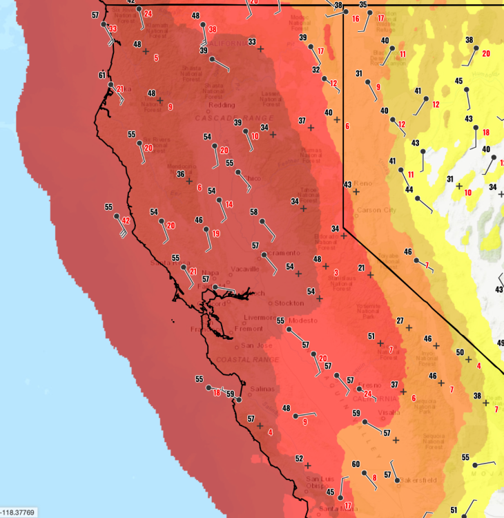
-
2022-2023 California and Southwest Weather Thread
NWbyNW replied to Thunder98's topic in West of the Rockies
Down to 63,000 power outages in the state. The biggest concentrations of outages are in Santa Cruz, Mendocino, Humbolt, and Sonoma Counties. -
2022-2023 California and Southwest Weather Thread
NWbyNW replied to Thunder98's topic in West of the Rockies
Yep. Been talking about that for a few pages. It's going to be both a blessing and a curse. It will help alleviate the drought conditions and fill up reservoirs, but flooding and damage will be significant. We're just seeing the tip of the ice berg right now. I would be surprised if the weather doesn't moderate somewhat, especially the stuff furthest out on the models. -
2022-2023 California and Southwest Weather Thread
NWbyNW replied to Thunder98's topic in West of the Rockies
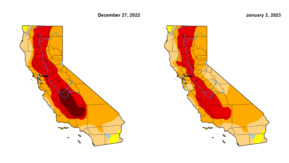
Too bad the latest drought monitor update doesn't reflect the past few storms, but it will in the future. Here it is showing the New Years-ish storms and we can see it has made a dent in the stubborn CA drought. Power outages across the state continue to decline. Now at around 70,000. Down from the near 200k last night. The biggest concentrations of outages are in Santa Cruz, Mendocino, Humbolt, and Sonoma Counties.