Prairiedog
-
Posts
1042 -
Joined
-
Last visited
-
Days Won
1
Everything posted by Prairiedog
-

December 2014 Observations for the Pacific Northwest
Prairiedog replied to stuffradio's topic in West of the Rockies
Suddenly we are in the mid 40's Fri. and Sat. Not exactly sure why. -
December 2014 Observations for the Pacific Northwest
Prairiedog replied to stuffradio's topic in West of the Rockies
I would agree. I think what is at stake here is that there are people on this great board that have a wide range of knowledge or levels of understanding. Sometimes the more "educated" or more "knowledgeable" become impatient with those of lesser degrees of "experiences". Some do a great job with it, some don't. Also, what is at stake here are how things are delivered. I've been an educator (science/biology) for close to 40 years and delivery is everything. Learning how to speak is golden. Learning how to deliver a point, defend something, or teach something or as you said, "help them see better", is an art. Teach one another how to learn. Otherwise it becomes criticism of the wrong kind, bullying, intimidation, attempts to embarrass, etc, etc. Over all people do a good job here but when the models light up and we get our few good chances per winter to score cold and snow, something happens. Sorta like the N. Korean's when they don't like our movies. -
December 2014 Observations for the Pacific Northwest
Prairiedog replied to stuffradio's topic in West of the Rockies
Some people here put a lot of work into interpreting daily models to come out with a forecast of sorts and some put a lot of science, logic, and intuition into LR forecasts. Esp. with LR work, its not only not easy, some of the science is simply not understood yet. My point is that with a lot of education, studying, trial and error, ongoing experiences, these things become their babies. It's called passion. Can't fault them for that. We all have our passions. Unfortunately everything done here is under scrutiny. That makes it open for hopefully constructive criticism when needed. If we post something we need to be open to that scrutiny. At the same time we need to respect the immense labor of love that went into their forecastiing. People get nailed on here maybe too often, people get baited. Everyone needs to find a way to show that respect for both the scrutiny AND the body of work that went into the forecasting. Shouldn't be that hard to do. -
December 2014 Observations for the Pacific Northwest
Prairiedog replied to stuffradio's topic in West of the Rockies
More and more geese are not even migrating anymore as local populations have exploded over the last 10 years or so. Whereas (as a birdwatcher) I only saw migrating geese a few times in the fall and spring, now there are literally tens of thousands of resident geese in the Willamette Valley. I see flocks almost everyday. My hunch is that you are seeing urban geese. -
December 2014 Observations for the Pacific Northwest
Prairiedog replied to stuffradio's topic in West of the Rockies
Driving from Portland to Winthrop on the 30th, coming back the 3rd. Going up the weather doesn't look difficult, just cold Coming back might get a little exciting. Spending New Years at Sun Mountain Lodge. Was hoping for Mtn. Home Lodge in Leavenworth but just not enough snow to snowshoe like we want although they may be getting a good dump in Leavenworth around the 3rd. Two winters in a row snow has come later there. Decent snow in Methow Valley. Coldest air may come in after New Years there. We shall see. Just don't want to deal with an ice storm down the Gorge or at least in and around Portland. Good snow storm brewing for eastern Wa and Idaho panhandle this weekend. Spokane looks to possibly get significant snow. -
December 2014 Observations for the Pacific Northwest
Prairiedog replied to stuffradio's topic in West of the Rockies
NWS forecast: Portland http://forecast.weather.gov/product.php?site=PQR&issuedby=PQR&product=AFD&format=CI&version=1&glossary=1 -
December 2014 Observations for the Pacific Northwest
Prairiedog replied to stuffradio's topic in West of the Rockies
You wonder what subtle changes are taking place in the atmosphere globally (perhaps chaos theory material to write about). A frog farts in N. Korea, a cat buries a cat turd in Russia, but whatever it is the ripples go far and wide that create the input the models digest. Things that haven't even happened yet, just things the computers are seeing or anticipating that go from what we saw last night to what we see today. I find it fascinating. Whatever the models saw last night, something sure as heck happened somewhere (or will happen) that leads to today's crud. No wonder model agreement is so difficult for cold and snow forecasting in the PNW. Cause and effect at it's finest (or worst). All the input that led to last nights output then suddenly all that input just changes in such a short amount of time to lead to this new output. Amazing. What the heck just happened? -
December 2014 Observations for the Pacific Northwest
Prairiedog replied to stuffradio's topic in West of the Rockies
I lost all my winter tomatoes that year. -
December 2014 Observations for the Pacific Northwest
Prairiedog replied to stuffradio's topic in West of the Rockies
Not the place for that here. -
December 2014 Observations for the Pacific Northwest
Prairiedog replied to stuffradio's topic in West of the Rockies
I ended the 24hr (last night at midnight with 1.33" of rain). Clackamas R. and Sandy R. up significantly but nothing that's a big deal. Would have been much bigger event if there had been any snow on the mountains. PUBLIC INFORMATION STATEMENT...CORRECTION NATIONAL WEATHER SERVICE PORTLAND OR 540 AM PST SUN DEC 21 2014 CORRECTION TO MOVE A SITE TO CORRECTION GEOGRAPHIC LOCATION ....RAINFALL TOTALS.... LISTED BELOW ARE RAINFALL REPORTS STARTING 4 AM FRI...DEC 19 THROUGH EARLY SUNDAY MORNING...DEC 21. THIS TIME PERIOD INCLUDES RAINFALL FROM A WEAK FRONT THAT MOVED THROUGH ON FRIDAY IN ADDITION TO THE CURRENT ATMOSPHERIC RIVER EVENT. LOCATION AMOUNT TIME/DATE LAT/LON ...CASCADE FOOTHILLS IN LANE COUNTY... TROUT CREEK 3.16 IN 0414 AM 12/21 44.11N/122.58W BRUSH CREEK 2.32 IN 0414 AM 12/21 44.28N/122.85W 2 WNW DISSTON 2.10 IN 0413 AM 12/21 43.73N/122.81W CRESWELL 0.4 SE 1.89 IN 0753 PM 12/20 43.91N/123.01W 2 W WALTERVILLE 1.87 IN 0437 AM 12/21 44.07N/122.85W 3 WSW DORENA RESERVOIR 1.43 IN 0434 AM 12/21 43.74N/122.99W ...CASCADES IN LANE COUNTY... ROARING RIVER 4.90 IN 0200 AM 12/21 43.90N/122.03W MCKENZIE 4.80 IN 0300 AM 12/21 44.21N/121.87W HOLLAND MEADOWS 3.90 IN 0200 AM 12/21 43.67N/122.57W SALT CREEK FALLS 3.70 IN 0200 AM 12/21 43.61N/122.12W EMIGRANT 2.67 IN 0353 AM 12/21 43.48N/122.23W RAILROAD OVERPASS 2.50 IN 0300 AM 12/21 43.66N/122.21W FIELDS 2.10 IN 0417 AM 12/21 43.68N/122.30W SUGARLOAF 1.19 IN 0406 AM 12/21 43.67N/122.65W ...CENTRAL COAST RANGE OF WESTERN OREGON... 2 NNW MAPLETON 7.70 IN 0230 AM 12/21 44.06N/123.88W CANNIBAL MOUNTAIN 5.58 IN 0403 AM 12/21 44.35N/123.89W SUMMIT 5.30 IN 0415 AM 12/21 44.63N/123.58W GRANDE RONDE 4.60 IN 0400 AM 12/21 45.05N/123.62W WILKINSON RIDGE 4.38 IN 0357 AM 12/21 44.33N/123.72W VILLAGE CREEK 4.32 IN 0353 AM 12/21 44.25N/123.47W HIGH POINT 3.07 IN 0353 AM 12/21 43.91N/123.40W ...CENTRAL COLUMBIA RIVER GORGE... HOOD RIVER-TUCKER BRIDGE 2.50 IN 0430 AM 12/21 45.65N/121.55W HOOD RIVER 2.35 IN 0437 AM 12/21 45.70N/121.54W HOOD RIVER AGRIMET 2.00 IN 0435 AM 12/21 45.68N/121.52W 1 ENE UNDERWOOD 1.82 IN 0437 AM 12/21 45.73N/121.53W ...CENTRAL OREGON COAST... 1 NW YACHATS 3.54 IN 0440 AM 12/21 44.32N/124.11W 2 NNE YACHATS 2.99 IN 0433 AM 12/21 44.34N/124.09W 1 NNE LINCOLN BEACH 2.98 IN 0431 AM 12/21 44.87N/124.04W DUNES 2.94 IN 0404 AM 12/21 43.96N/124.12W FLORENCE #2 2.92 IN 1200 AM 12/21 44.00N/124.09W NEWPORT MUNI AP 2.66 IN 0355 AM 12/21 44.58N/124.05W 1 S OTTER ROCK 2.55 IN 0440 AM 12/21 44.72N/124.06W 2 N LINCOLN CITY 2.49 IN 0438 AM 12/21 45.01N/124.01W NEWPORT 2.43 IN 0434 AM 12/21 44.64N/124.06W 1 SE HECETA BEACH 2.23 IN 0434 AM 12/21 44.02N/124.12W WALDPORT 2.13 IN 0436 AM 12/21 44.42N/124.07W ...CENTRAL WILLAMETTE VALLEY... 6 SW PIKE 5.90 IN 0430 AM 12/21 45.31N/123.35W MILLER WOODS 4.20 IN 0300 AM 12/21 45.24N/123.26W 4 SSW DALLAS 3.57 IN 0437 AM 12/21 44.86N/123.34W 1 WSW DALLAS 2.98 IN 0440 AM 12/21 44.92N/123.33W 1 NW RICKREALL 2.54 IN 0346 AM 12/21 44.95N/123.25W 3 WSW SCHOLLS 2.44 IN 0428 AM 12/21 45.36N/123.01W MC MINNVILLE MUNICIPAL AIRPO 2.01 IN 0353 AM 12/21 45.19N/123.13W SALEM AP (MCNARY FIELD) 1.98 IN 0356 AM 12/21 44.91N/123.00W 2 ENE YAMHILL 1.90 IN 0418 AM 12/21 45.35N/123.14W MARION 1.86 IN 0438 AM 12/21 44.75N/122.93W 1 S SALEM 1.86 IN 0431 AM 12/21 44.90N/123.03W 4 NNE COLTON 1.80 IN 0232 AM 12/21 45.24N/122.44W 1 SSE AUMSVILLE 1.78 IN 0434 AM 12/21 44.83N/122.86W 1 W NEWBERG 1.77 IN 0440 AM 12/21 45.30N/122.99W FALLS CITY 1.77 IN 0400 AM 12/21 44.88N/123.46W 1 WSW SALEM 1.58 IN 0437 AM 12/21 44.92N/123.06W AURORA STATE AIRPORT 1.51 IN 0353 AM 12/21 45.25N/122.77W CANBY 1.49 IN 0400 AM 12/21 45.24N/122.69W 3 WNW DUNDEE 1.43 IN 0428 AM 12/21 45.29N/123.06W SILVERTON 1.29 IN 0435 AM 12/21 45.01N/122.77W SCOTTS MILLS 1.22 IN 0437 AM 12/21 45.04N/122.66W ...COAST RANGE OF NORTHWEST OREGON... LEES CAMP 7.30 IN 0400 AM 12/21 45.59N/123.52W 4 ESE HEBO 6.57 IN 0410 AM 12/21 45.21N/123.77W RYE MOUNTAIN 6.52 IN 0414 AM 12/21 45.22N/123.53W 4 E HEBO 6.26 IN 0439 AM 12/21 45.21N/123.75W SADDLE MOUNTAIN 6.10 IN 0400 AM 12/21 45.54N/123.37W 1 WNW JEWELL 5.60 IN 0400 AM 12/21 45.94N/123.53W NEHALEM RIVER NR FOSS 5.42 IN 0400 AM 12/21 45.70N/123.75W TILLAMOOK 8 ENE 5.39 IN 0430 AM 12/21 45.48N/123.72W SOUTH FORK 5.37 IN 0412 AM 12/21 45.60N/123.48W ROCKHOUSE 1 4.43 IN 0412 AM 12/21 44.92N/123.47W TIDEWATER 4.35 IN 0414 AM 12/21 46.01N/123.56W SEINE CREEK 4.30 IN 0300 AM 12/21 45.53N/123.30W MILLER 2.44 IN 0412 AM 12/21 46.02N/123.27W NEHALEM RIVER NR VERNONIA 1.76 IN 0415 AM 12/21 45.81N/123.28W ...GREATER PORTLAND METRO AREA... SCOGGINS CRK BLO HENRY HAGG 2.93 IN 0400 AM 12/21 45.47N/123.20W TUALATIN R NR GASTON 2.40 IN 0415 AM 12/21 45.44N/123.17W 1 NW FOREST GROVE 2.17 IN 0430 AM 12/21 45.54N/123.13W 2 WNW FOREST GROVE 1.96 IN 0429 AM 12/21 45.53N/123.14W SHERWOOD 1.76 IN 0413 AM 12/21 45.35N/122.84W SCAPPOOSE INDUSTRIAL AIRPARK 1.73 IN 0353 AM 12/21 45.77N/122.86W TUALATIN 1.70 IN 0440 AM 12/21 45.37N/122.76W 4 WNW FARMINGTON 1.70 IN 0426 AM 12/21 45.47N/123.02W CANBY 1.66 IN 0435 AM 12/21 45.27N/122.69W GRESHAM 1.60 IN 0430 AM 12/21 45.48N/122.42W 1 WSW DAMASCUS 1.59 IN 0435 AM 12/21 45.40N/122.50W MOMPANO RESERVOIR ON ABERNET 1.58 IN 0415 AM 12/21 45.31N/122.51W OREGON CITY 1.58 IN 0440 AM 12/21 45.34N/122.61W 1 NNE CANBY 1.57 IN 0439 AM 12/21 45.28N/122.69W 1 NW WEST LINN 1.54 IN 0439 AM 12/21 45.38N/122.66W CORNELIUS 1.53 IN 0434 AM 12/21 45.51N/123.06W 2 SSW MT TABOR 1.47 IN 0440 AM 12/21 45.48N/122.61W TIGARD 1.47 IN 0440 AM 12/21 45.41N/122.77W 3 E OREGON CITY 1.45 IN 0438 AM 12/21 45.34N/122.53W KGW-TV 1.45 IN 1000 PM 12/20 45.52N/122.69W 2 W BORING 1.44 IN 0441 AM 12/21 45.43N/122.42W 1 ENE CEDAR HILLS 1.43 IN 0629 PM 12/20 45.51N/122.79W 1 SW OREGON CITY 1.42 IN 0438 AM 12/21 45.33N/122.61W 2 S ALOHA 1.41 IN 0437 AM 12/21 45.45N/122.87W KING CITY 1.39 IN 0434 AM 12/21 45.40N/122.80W 1 WNW MT TABOR 1.35 IN 0437 AM 12/21 45.52N/122.61W FARMINGTON 1.35 IN 0439 AM 12/21 45.46N/122.95W 2 NNW CEDAR HILLS 1.34 IN 0438 AM 12/21 45.53N/122.82W 2 NW TIGARD 1.31 IN 0439 AM 12/21 45.44N/122.80W 1 SW OAK GROVE 1.30 IN 0437 AM 12/21 45.39N/122.66W 1 NE UNIVERSITY OF PORTLAND 1.30 IN 0430 AM 12/21 45.59N/122.71W 1 SSE SYLVAN 1.29 IN 0437 AM 12/21 45.49N/122.72W 3 SE CLACKAMAS 1.26 IN 0439 AM 12/21 45.37N/122.52W 1 E ROCKCREEK 1.25 IN 0437 AM 12/21 45.55N/122.85W WILLAMETTE RIVER NR OREGON C 1.24 IN 0415 AM 12/21 45.36N/122.61W WOOD VILLAGE 1.23 IN 0438 AM 12/21 45.53N/122.41W 2 ESE DURHAM 1.22 IN 0440 AM 12/21 45.38N/122.72W PORTLAND INTERNATIONAL AIRPO 1.18 IN 0353 AM 12/21 45.59N/122.60W 1 NNE SWAN ISLAND 1.17 IN 0438 AM 12/21 45.58N/122.70W HILLSBORO AIRPORT ASOS & LAW 1.17 IN 0353 AM 12/21 45.54N/122.95W 1 SSW MT TABOR 1.17 IN 0427 AM 12/21 45.49N/122.60W 1 ENE ROCKCREEK 1.15 IN 0438 AM 12/21 45.56N/122.85W 1 ENE SELLWOOD 1.14 IN 0440 AM 12/21 45.47N/122.64W WFO PORTLAND ROOFTOP WEATHER 1.12 IN 0400 AM 12/21 45.56N/122.54W 2 WSW DAMASCUS 1.11 IN 0418 AM 12/21 45.41N/122.50W 1 ENE MILWAUKIE 1.09 IN 0436 AM 12/21 45.45N/122.61W 1 ESE HAPPY VALLEY 1.07 IN 0438 AM 12/21 45.43N/122.50W 1 S ALOHA 1.04 IN 0426 AM 12/21 45.48N/122.87W 1 SE PORTLAND DOWNTOWN 1.03 IN 0432 AM 12/21 45.50N/122.67W 2 N DAMASCUS 1.02 IN 0441 AM 12/21 45.44N/122.46W 1 S TROUTDALE 1.00 IN 0439 AM 12/21 45.53N/122.39W 2 W HILLSBORO 0.99 IN 0438 AM 12/21 45.53N/122.99W 1 NW RALEIGH HILLS 0.98 IN 0429 AM 12/21 45.50N/122.77W 2 E TIGARD 0.97 IN 0438 AM 12/21 45.43N/122.74W HILLSBORO 0.96 IN 0401 AM 12/21 45.52N/122.94W 2 S RALEIGH HILLS 0.93 IN 0441 AM 12/21 45.46N/122.76W 2 ENE HAPPY VALLEY 0.93 IN 0440 AM 12/21 45.46N/122.50W PORTLAND-TROUTDALE AIRPORT 0.73 IN 0353 AM 12/21 45.55N/122.40W ...GREATER VANCOUVER AREA... LARCH MOUNTAIN 2.94 IN 0409 AM 12/21 45.72N/122.35W 1 ESE HEISSON 1.72 IN 0410 AM 12/21 45.81N/122.46W BATTLE GROUND 1.55 IN 0438 AM 12/21 45.79N/122.54W 1 NE LACAMAS LAKE 1.48 IN 0441 AM 12/21 45.62N/122.41W BATTLE GROUND 1.39 IN 0436 AM 12/21 45.79N/122.54W LACAMAS LAKE 1.35 IN 0431 AM 12/21 45.61N/122.43W 1 NNW LACAMAS LAKE 1.28 IN 0436 AM 12/21 45.62N/122.44W 1 SE ORCHARDS 1.24 IN 0438 AM 12/21 45.65N/122.53W PEARSON FIELD AIRPORT 1.16 IN 0353 AM 12/21 45.62N/122.66W 1 WNW ORCHARDS 1.13 IN 0439 AM 12/21 45.67N/122.57W 2 ESE ORCHARDS 1.09 IN 0440 AM 12/21 45.65N/122.52W 1 NNW EVERGREEN 0.93 IN 0400 AM 12/21 45.65N/122.53W MINNEHAHA 0.91 IN 0437 AM 12/21 45.65N/122.62W 1 NE HAZEL DELL 0.88 IN 0432 AM 12/21 45.69N/122.65W ...LOWER COLUMBIA... SAINT HELENS 1.13 IN 0439 AM 12/21 45.85N/122.82W ...LOWER COLUMBIA AND I - 5 CORRIDOR IN COWLITZ COUNTY... CASTLE ROCK 2.34 IN 0409 AM 12/21 46.27N/122.89W 2 WNW LONGVIEW 1.96 IN 0440 AM 12/21 46.15N/122.98W KELSO-LONGVIEW AIRPORT 1.65 IN 0355 AM 12/21 46.12N/122.89W 2 W LEXINGTON 1.34 IN 0433 AM 12/21 46.18N/122.95W 1 SSW WOODLAND 1.27 IN 0433 AM 12/21 45.90N/122.75W ...NORTH OREGON COAST... TILLAMOOK 4.02 IN 0412 AM 12/21 45.46N/123.80W W F SATSOP RIVER 3.89 IN 0430 AM 12/21 46.18N/123.56W TILLAMOOK AIRPORT 3.55 IN 0355 AM 12/21 45.42N/123.82W WILSON R AT TILLAMOOK 3.28 IN 0400 AM 12/21 45.48N/123.81W PACIFIC CITY 2.62 IN 0438 AM 12/21 45.20N/123.97W 3 SW SANDLAKE 2.62 IN 0429 AM 12/21 45.26N/123.95W 2 E OCEANSIDE 2.56 IN 0437 AM 12/21 45.47N/123.92W ASTORIA AIRPORT 2.47 IN 0355 AM 12/21 46.16N/123.88W KNAPPA 2.39 IN 0429 AM 12/21 46.17N/123.58W 1 WSW ASTORIA 2.00 IN 0400 AM 12/21 46.18N/123.84W OCEANSIDE 1.90 IN 0438 AM 12/21 45.46N/123.97W 1 ESE PACIFIC CITY 1.88 IN 0438 AM 12/21 45.18N/123.93W CANNON BEACH 1.66 IN 0431 AM 12/21 45.89N/123.96W ...NORTHERN OREGON CASCADE FOOTHILLS... YELLOWSTONE MTN 6.91 IN 0417 AM 12/21 44.59N/122.43W PEBBLE 4.88 IN 0353 AM 12/21 44.23N/122.99W HORSE CREEK 3.80 IN 0427 AM 12/21 44.95N/122.40W 6 ENE SILVER FALLS 3.10 IN 0400 AM 12/21 44.95N/122.52W 2 NE CHERRYVILLE 2.61 IN 0432 AM 12/21 45.39N/122.11W HEADWORKS PORTLAND WATER BUR 2.49 IN 1200 AM 12/21 45.45N/122.15W SWEET HOME 2.22 IN 0436 AM 12/21 44.40N/122.70W 4 SSW ESTACADA 1.85 IN 0431 AM 12/21 45.23N/122.35W 1 WSW SWEET HOME 1.59 IN 0330 AM 12/21 44.39N/122.72W 3 SSE SHORTYS CORNER 1.28 IN 0431 AM 12/21 45.35N/122.20W EAGLE CREEK 1.06 IN 0413 AM 12/21 45.37N/122.33W 5 E WATERLOO 1.05 IN 0440 AM 12/21 44.50N/122.72W ...NORTHERN OREGON CASCADES... BLAZED ALDER 7.20 IN 0200 AM 12/21 45.43N/121.86W JUMP OFF JOE 6.10 IN 0300 AM 12/21 44.39N/122.17W LOG CREEK 5.55 IN 0406 AM 12/21 45.50N/121.90W RED HILL 5.50 IN 0300 AM 12/21 45.46N/121.70W BOULDER CREEK 5.45 IN 0358 AM 12/21 44.72N/122.00W WANDERERS PEAK 5.01 IN 0407 AM 12/21 45.11N/122.20W SANTIAM JUNCTION 4.80 IN 0300 AM 12/21 44.44N/121.95W DALY LAKE 4.60 IN 0200 AM 12/21 44.52N/122.09W CLACKAMAS LAKE 4.50 IN 0300 AM 12/21 45.10N/121.75W HOGG PASS 4.50 IN 0200 AM 12/21 44.42N/121.86W MT HOOD TEST SITE 4.10 IN 0200 AM 12/21 45.32N/121.72W THREE LYNX 3.80 IN 0415 AM 12/21 45.13N/122.07W MUD RIDGE 3.50 IN 0100 AM 12/21 45.25N/121.74W RED BOX 3.14 IN 0407 AM 12/21 45.03N/121.92W PEAVINE RIDGE 2.90 IN 0200 AM 12/21 45.04N/121.93W LITTLE MEADOWS 1.36 IN 1100 PM 12/20 44.61N/122.23W NORTH FORK 1.34 IN 1200 AM 12/21 45.55N/122.00W MARION FORKS 1.32 IN 1100 PM 12/20 44.59N/121.97W ...SOUTH WILLAMETTE VALLEY... CORVALLIS 2.58 IN 0345 AM 12/21 44.42N/123.33W 1 S NORTH ALBANY 2.35 IN 0438 AM 12/21 44.65N/123.12W MONROE 2.18 IN 0432 AM 12/21 44.32N/123.31W 2 S PHILOMATH 2.11 IN 0434 AM 12/21 44.50N/123.35W EUGENE-MAHLON SWEET FIELD 2.08 IN 0354 AM 12/21 44.13N/123.22W CORVALLIS MUNICIPAL AIRPORT 2.04 IN 0355 AM 12/21 44.50N/123.29W 7 ESE CROW 1.85 IN 0438 AM 12/21 43.94N/123.22W SANTA CLARA 1.77 IN 0433 AM 12/21 44.11N/123.15W 2 NW LACOMB 1.74 IN 0440 AM 12/21 44.61N/122.76W EUGENE 1.69 IN 0432 AM 12/21 44.05N/123.11W WILLOW CREEK 1.65 IN 0354 AM 12/21 44.03N/123.17W 2 SW CORVALLIS 1.61 IN 0431 AM 12/21 44.55N/123.29W 3 ENE EUGENE 1.59 IN 0437 AM 12/21 44.08N/123.06W 3 W SPRINGFIELD 1.59 IN 0433 AM 12/21 44.05N/123.04W ...SOUTH WASHINGTON CASCADE FOOTHILLS... COUGAR 6.14 IN 0304 AM 12/21 46.06N/122.29W 1 WSW YALE 4.70 IN 0433 AM 12/21 46.00N/122.40W CALAMITY 3.80 IN 0300 AM 12/21 45.90N/122.22W CANYON CREEK 3.33 IN 0352 AM 12/21 45.92N/122.30W YALE LAKE 1.73 IN 0642 PM 12/20 45.96N/122.33W N FK TOUTLE R BLO SRS 1.54 IN 0400 AM 12/21 46.37N/122.58W KALAMA FALLS HATCHERY 1.45 IN 1000 PM 12/20 46.02N/122.73W ...SOUTH WASHINGTON CASCADES... SWIFT CREEK 6.40 IN 0300 AM 12/21 46.16N/122.18W JUNE LAKE 6.00 IN 0200 AM 12/21 46.15N/122.15W SHEEP CANYON 5.50 IN 0200 AM 12/21 46.19N/122.25W 2 WSW SPIRIT LAKE 5.00 IN 0300 AM 12/21 46.26N/122.18W DRY CREEK 4.88 IN 0425 AM 12/21 45.94N/121.99W SURPRISE LAKES 4.00 IN 0200 AM 12/21 46.09N/121.76W LONE PINE 3.80 IN 0300 AM 12/21 46.27N/121.96W SPENCER MEADOW 3.80 IN 0300 AM 12/21 46.18N/121.93W BUCK CREEK 2.53 IN 0425 AM 12/21 46.06N/121.54W ELK ROCK 2.49 IN 0401 AM 12/21 46.31N/122.39W ORR CREEK 2.08 IN 0409 AM 12/21 46.36N/121.60W 3 SW COLDWATER RIDGE VISITOR 1.97 IN 0231 AM 12/21 46.25N/122.34W ...SOUTH WASHINGTON COAST... 1 N KLIPSAN BEACH 2.00 IN 0438 AM 12/21 46.48N/124.05W 1 ENE LONG BEACH 1.94 IN 0436 AM 12/21 46.36N/124.03W LONG BEACH 1.76 IN 0438 AM 12/21 46.35N/124.05W ...UPPER HOOD RIVER VALLEY... MIDDLE MTN 2.61 IN 0414 AM 12/21 45.58N/121.60W 3 E DEE 2.30 IN 0434 AM 12/21 45.57N/121.55W ...WESTERN COLUMBIA RIVER GORGE... BONNEVILLE DAM 4.90 IN 0345 AM 12/21 45.63N/121.96W LOCKS 3.81 IN 0408 AM 12/21 45.67N/121.88W PRINDLE 2.13 IN 0400 AM 12/21 45.59N/122.16W 2 SSE ROOSTER ROCK STATE PAR 1.79 IN 0431 AM 12/21 45.52N/122.22W 1 E CORBETT 1.40 IN 0439 AM 12/21 45.53N/122.27W ...WILLAPA HILLS... ABERNATHY MTN 4.49 IN 0401 AM 12/21 46.35N/123.10W HUCKLEBERRY RIDGE 3.76 IN 0411 AM 12/21 46.50N/123.38W ROCK CREEK 3.57 IN 0330 AM 12/21 46.53N/123.40W BROOKLYN 2.55 IN 0430 AM 12/21 46.73N/123.55W FRANCES 2.30 IN 0830 PM 12/20 46.54N/123.50W -
December 2014 Observations for the Pacific Northwest
Prairiedog replied to stuffradio's topic in West of the Rockies
Don't expect everyone to dumb everything down for you Most people on here are self taught. Not all, but many. Start looking things up. Start doing some digging and teach yourself. Ask some intelligent questions instead of expecting. But being a smartass towards others that are good contributors on this board, really makes yourself look entitled and lazy. -
December 2014 Observations for the Pacific Northwest
Prairiedog replied to stuffradio's topic in West of the Rockies
N. Koreans hacked the 18Z. But then again, they don't know about the new parallel GFS. Un-hackable says accuweather. -
December 2014 Observations for the Pacific Northwest
Prairiedog replied to stuffradio's topic in West of the Rockies
Little ones for sure, Abbi anyway. On time? Twins tend to come a little early and run a little smaller. Gosh, that brings back memories. Wow. Better than puppy breath any day. Invest in toilet paper stock now. Amazing how usage went up. I didn't see the inside of a bathroom for years. The deck became my friend. Oh, did I mention I had two other daughters as well? Four daughters and a wife, I had two and a half baths and still saw very little "time" in the bathroom. -
December 2014 Observations for the Pacific Northwest
Prairiedog replied to stuffradio's topic in West of the Rockies
Congrtats Andrew! My twin daughters are now 23. The work load for a while is exponential not just double but with family and friends helping, it makes all the difference in the world. Getting sleep (working in shifts is key), feedings at the same time to get them to sleep at the same time so you all can sleep is also key. In the end, its amazing. Sleep is king! -
December 2014 Observations for the Pacific Northwest
Prairiedog replied to stuffradio's topic in West of the Rockies
This may be the second Dec 28-Jan 1 that we have had to cancel our trip to Mountain Home Lodge (1,000ft above Leavenworth). Three years ago we had about 15" on the ground for snowshoeing and sledding but last year at that time, nothing. We always celebrate our anniversary there and usually don't have trouble with snow. This year, just a trace on the ground at the lodge down from several inches from last week. Nothing in the near future that I can see. Need to cancel early next week if it's not going to snow then. Stinks. All the resorts are going to suffer as well. -
December 2014 Observations for the Pacific Northwest
Prairiedog replied to stuffradio's topic in West of the Rockies
Watching the GFS pick up on this storm and never really flinching while the other models played catch up was actually the most interesting part of this event for me. I wonder what made this event such a lock for the GFS? The data was there and it held up. I still see the GFS as lagging behind the EC but what made it hold up here, I don't know. In previous wind events has the GFS performed as well? I don't remember what happened in Oct. The other thing that was quite interesting was how the valley here (and parts of E. Or) had wind gusts very comparable for the most part with the coast. The coast forecast was pretty much a bust as schools in some locations closed. Coastal schools rarely close for wind events. Typically after AR or wind events we can start to look for a reload of cold air to the north. The snow situation in the mountains is awful and I don't see anything to alleviate that in the next couple weeks. Not going to be a good Christmas for the mountain ski resorts. -
December 2014 Observations for the Pacific Northwest
Prairiedog replied to stuffradio's topic in West of the Rockies
GFS has been very consistent with the wind analysis and the other models pretty much caught up. Only a few (very few) people have said winds would be 70+ for the Portland area. There hasn't been any "substantial" downgrade at all. Perhaps 5-10mph at best, but predicting winds that close is like predicting exact snowfall. It's going to get windy here. There are going to be power outages here. That makes it significant and substantial for some people. Is it a top tier windstorm, no. Was the potential there, yes. But none of the models really predicted anything more than what its showing now. Seems that there are extremists on both ends of this. -
December 2014 Observations for the Pacific Northwest
Prairiedog replied to stuffradio's topic in West of the Rockies
I must have missed something. Links please to your analysis. -
December 2014 Observations for the Pacific Northwest
Prairiedog replied to stuffradio's topic in West of the Rockies
Waters off the Gulf and Atlantic are in the 70's. Waters here even in an El Nino are in the 40's and 50's. I can't imagine those temps would feed a "hurricane" much. Cold air is what is feeding the cyclogenesis of these storms along with a powerful jet. Correct me if I'm wrong. Yes, there is a lot more in the dynamics of the formation of our winter storms but in a nutshell, I don't think the "warm" waters off our coast do much in formation. Split flow perhaps. -
December 2014 Observations for the Pacific Northwest
Prairiedog replied to stuffradio's topic in West of the Rockies
I've gone from 47 this morning to 59 (20 miles SE of PDX between Estacada and Oregon City). Temp has jumped 3f in the last 15 minutes. Calm as can be. I hear moss growing. -
December 2014 Observations for the Pacific Northwest
Prairiedog replied to stuffradio's topic in West of the Rockies
Global warning. I remember as a kid when my snow forts would last until March in the Willamette Valley. Sucks now. -
I hit 45. Had all the windows open and dang. Chemult down to 28f, Sisters at 34. High desert growing season drawing close to its end.
-
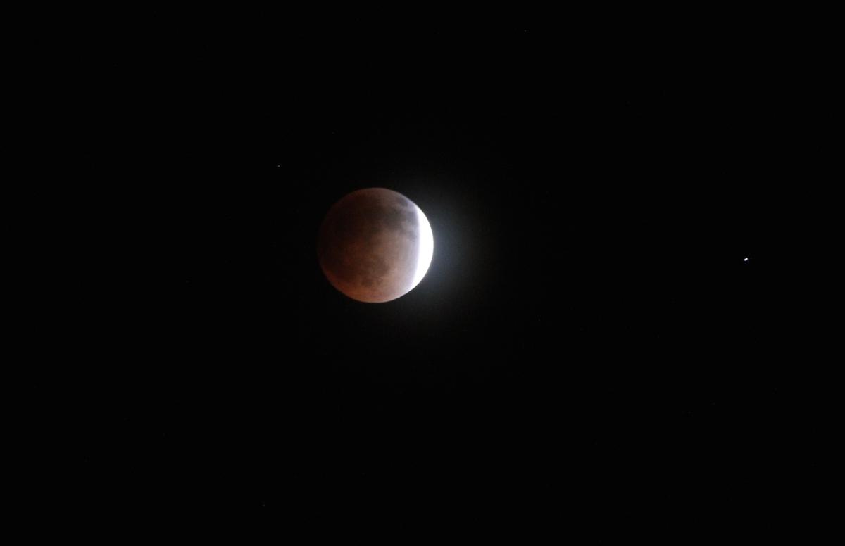
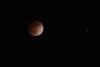
Spectacular event. Took my camp chair, hot chocolate, camera gear and was serenaded by coyotes as well. Just a great evening all the way around.


-
Hit 70f today, gorgeous day. 5 straight mornings with frost. 31f this morning, 30f yesterday and 27f the coldest of the days the day before that. About to come to a screeching halt on both ends of the temp readings for the next 6 days at least.
-
Its been broken for the last week or so. We are taking up a collection for Mark to go up with Stephanie and Sonja to put up a new one.