
MossMan
-
Posts
33432 -
Joined
-
Last visited
-
Days Won
64
Everything posted by MossMan
-

December 2014 Observations for the Pacific Northwest
MossMan replied to stuffradio's topic in West of the Rockies
Glad my Eastern Wa drive was yesterday, looks like some Ice Storm Warnings over there today! -
December 2014 Observations for the Pacific Northwest
MossMan replied to stuffradio's topic in West of the Rockies
Good mountain snow though? -
December 2014 Observations for the Pacific Northwest
MossMan replied to stuffradio's topic in West of the Rockies
Yep, up to 35 degrees and the sound of dripping here as well. It was a nice run though! -
December 2014 Observations for the Pacific Northwest
MossMan replied to stuffradio's topic in West of the Rockies
It has been amazing to me that I still have about 80% of my last Fri night/Sat morning snowfall with full out sun every day and above freezing highs for the last two days! My low last night was 20, and was dropping like a rock until about an hour ago. Was at 28, now at 31. Looks like the melt a Thon will be commencing shortly -
December 2014 Observations for the Pacific Northwest
MossMan replied to stuffradio's topic in West of the Rockies
Yeah I drove to Pasco and back today and the temp spiked to 46 degrees just east of North Bend but yet there was still frost in the shade and it didn't look like anything was melting at all! -
December 2014 Observations for the Pacific Northwest
MossMan replied to stuffradio's topic in West of the Rockies
I am currently at 29 degrees and it looks like most all of my snow survived another day!! -
December 2014 Observations for the Pacific Northwest
MossMan replied to stuffradio's topic in West of the Rockies
I was on board that train! -
December 2014 Observations for the Pacific Northwest
MossMan replied to stuffradio's topic in West of the Rockies
Currently 26 degrees, feels like a heat wave! -
December 2014 Observations for the Pacific Northwest
MossMan replied to stuffradio's topic in West of the Rockies
Back down to 29 degrees. Going to be sad when things start dripping tomorrow -
December 2014 Observations for the Pacific Northwest
MossMan replied to stuffradio's topic in West of the Rockies
True. Though I could listen to "Let it snow" and "Dreaming Of A White Christmas" over and over and over... -
December 2014 Observations for the Pacific Northwest
MossMan replied to stuffradio's topic in West of the Rockies
Yeah nothing melted today at work so I should arrive home with pretty much the same amount of snow as when I left this morning!! Dew points must still be low. -
December 2014 Observations for the Pacific Northwest
MossMan replied to stuffradio's topic in West of the Rockies
Even though our temp drop wasn't nearly as extreme, it was nearly 60 degrees at my house on Thanksgiving day, then on Friday morning it was 53 degrees at 5am, by 8am it was 42! Pretty big deal for our standards! -
December 2014 Observations for the Pacific Northwest
MossMan replied to stuffradio's topic in West of the Rockies
You know you are a weather freak when you pick your outdoor lighting with the thought of snow in mind. I wanted something that looked nice but was brighter than your typical Christmas lighting so I found these nice looking but bright lights that would pick up Falling snow perfectly. They did not disappoint. And I just find myself staring at the snow on the deck at night...with dog paw prints of course! Took this last night.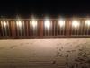
-
December 2014 Observations for the Pacific Northwest
MossMan replied to stuffradio's topic in West of the Rockies
Was 19 when I left my house about 45min ago. I wish we would stay cold and dry all week, most all of my snow is still preserved right now. -
December 2014 Observations for the Pacific Northwest
MossMan replied to stuffradio's topic in West of the Rockies
Oh and it's 23 degrees here at my house, looks like I am going to make it to the teens once again! -
December 2014 Observations for the Pacific Northwest
MossMan replied to stuffradio's topic in West of the Rockies
I wish there were historical data in my 7 Lakes micro climate for 1950. Hard to base it off of Everett data, or even Arlington for that matter. I really hope we can experience a 1950 event before we all die of old age...or too many Mc Ribs. -
December 2014 Observations for the Pacific Northwest
MossMan replied to stuffradio's topic in West of the Rockies
I think you will get one, but not the other. -
December 2014 Observations for the Pacific Northwest
MossMan replied to stuffradio's topic in West of the Rockies
What would everyone like, 1950 or 1880? Was there a month long event like 1950 but even more epic? I want complete epic ness!! -
December 2014 Observations for the Pacific Northwest
MossMan replied to stuffradio's topic in West of the Rockies
Sounds great, I am game for a repeat! -
December 2014 Observations for the Pacific Northwest
MossMan replied to stuffradio's topic in West of the Rockies
Not a bad run, it was a great Thanksgiving day which was mostly dry, but warm gusty south winds. I love days like that. Then the Seahawks won. Then the rain turned to snow around 11pm on Friday night, woke up to 2" of snow on the ground Saturday morning with a temp that fell from 31 degrees at 7am to 21 degrees by 7pm. Had a low of 17 on Sunday morning, and the same this morning. Still only 30 at my house, haven't been above freezing since Friday evening. Most of my snow is still on the ground and in the trees, I like it!!! -
December 2014 Observations for the Pacific Northwest
MossMan replied to stuffradio's topic in West of the Rockies
Looks pretty much like my yard still! -
December 2014 Observations for the Pacific Northwest
MossMan replied to stuffradio's topic in West of the Rockies
Currently 19 degrees here this morning, hopefully a drop at sunrise as well. -
December 2014 Observations for the Pacific Northwest
MossMan replied to stuffradio's topic in West of the Rockies
The turn around didn't take very long the last time, only two weeks! -
Your Personal Favorite Weather Events
MossMan replied to bainbridgekid's topic in West of the Rockies
My top 5 events of my lifetime would be... #5 December 1990 (about 14" of snow, single digit temps, snow Christmas morning) #4 November 1985 (about 12" of snow, Lake Goodwin froze over) #3 December 1996 (about 24" of snow, insane snowfall rates in a short period) #2 November 2006 (about 17" of heavy wet snow that caused major tree damage, no power for 4 days) #1 December 2008 (about 36" of snow, the duration that the event lasted, and heavy snow Christmas morning) For January's I would say 1996 would be my favorite. About a foot of snow and very cold temps. -
I saved the all the SWS during the Dec 2008 event, this was the first official one...oh the memories! Though if I remember correctly didn't we start tracking the first signs of the big change around the last week of November? SPECIAL WEATHER STATEMENT NATIONAL WEATHER SERVICE SEATTLE WA 315 PM PST MON DEC 8 2008 SAN JUAN COUNTY-WESTERN WHATCOM COUNTY-SOUTHWEST INTERIOR- EAST PUGET SOUND LOWLANDS-WESTERN SKAGIT COUNTY-EVERETT AND VICINITY- SEATTLE/BREMERTON AREA-TACOMA AREA-ADMIRALTY INLET AREA- HOOD CANAL AREA-LOWER CHEHALIS VALLEY AREA-OLYMPICS- EASTERN STRAIT OF JUAN DE FUCA-WESTERN STRAIT OF JUAN DE FUCA- NORTH COAST-CENTRAL COAST-WEST SLOPES NORTHERN CASCADES AND PASSES- WEST SLOPES CENTRAL CASCADES AND PASSES- 315 PM PST MON DEC 8 2008 ...MUCH COLDER WEATHER IS EXPECTED THIS WEEKEND... A MAJOR CHANGE WILL OCCUR IN THE LARGE SCALE PATTERN NEAR THE END OF THIS WEEK...BRINGING MUCH COLDER WEATHER TO WESTERN WASHINGTON OVER THE WEEKEND. THE TRANSITION WILL GET UNDERWAY FRIDAY OR FRIDAY NIGHT...AS A COLD FRONT AND ITS UPPER TROUGH SWING SOUTHEAST FROM THE GULF OF ALASKA ACROSS THE PACIFIC NORTHWEST. IN THE WAKE OF THE COLD FRONT...COLDER AIR WILL MOVE FROM SOUTHWEST CANADA INTO WESTERN WASHINGTON OVER THE WEEKEND. WE CAN EXPECT TEMPERATURES TO FALL BELOW FREEZING...AT LEAST DURING THE NIGHT AND MORNING HOURS...ACROSS MOST OF WESTERN WASHINGTON THIS WEEKEND AND EARLY NEXT WEEK. PEOPLE SHOULD BE READY FOR WEATHER THAT IS COLD ENOUGH TO CAUSE ICY ROADS...BURST OUTDOOR PIPES...AND ENDANGER PETS. THE TROUGH WILL BRING SOME MUCH NEEDED SNOW TO THE CASCADES AND OLYMPIC MOUNTAINS FRIDAY AND FRIDAY NIGHT...FOLLOWED BY SCATTERED SNOW SHOWERS OVER THE WEEKEND. THERE IS ALSO A POSSIBILITY OF SNOWFALL ACROSS THE WESTERN WASHINGTON LOWLANDS...PERHAPS AS EARLY AS FRIDAY NIGHT...BUT IT IS TOO EARLY TO SAY WITH ANY CONFIDENCE WHETHER OR NOT THIS WILL OCCUR. WESTERN WASHINGTON RESIDENTS SHOULD KEEP INFORMED OF THE LATEST NATIONAL WEATHER SERVICE FORECASTS AND STATEMENTS AS THIS SITUATION UNFOLDS BY LISTENING TO NOAA WEATHER RADIO OR VISITING OUR WEB PAGE AT WEATHER.GOV/SEATTLE (ALL LOWERCASE). MCDONNAL WEATHER.GOV/SEATTLE

