Tenochtitlan
-
Posts
501 -
Joined
-
Last visited
-
Days Won
2
Everything posted by Tenochtitlan
-
January Weather In The PNW 2024 (Part III) - The Warming Shot
Tenochtitlan replied to iFred's topic in West of the Rockies
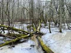
Oaks Bottom Wildlife Refuge was still wintry today. The third picture is a large lagoon that is almost completely frozen over. Plenty of ice and snow covering the trails, a fallen tree, and eerie fog hovering over the cold ground. *Hmm, not sure why the quality on these photos is so low.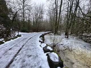


-
January Weather In The PNW 2024 (Part III) - The Warming Shot
Tenochtitlan replied to iFred's topic in West of the Rockies
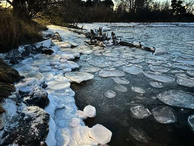
Here are some pictures I took of the pancake ice in Padden Creek estuary in Bellingham. I took these on the evening of the 12th, the day the weather station right on the water in Fairhaven recorded a high of just 15 degrees. I'd never seen this pocket estuary freeze over in previous Arctic events. Yet, the cold was so intense this time that these large circles of ice formed in just one day! I tried to pick one up--it was heavy and solid. This is the same kind of ice that forms in the Arctic! I believe it's a result of wave action. One of the cooler things I've ever seen.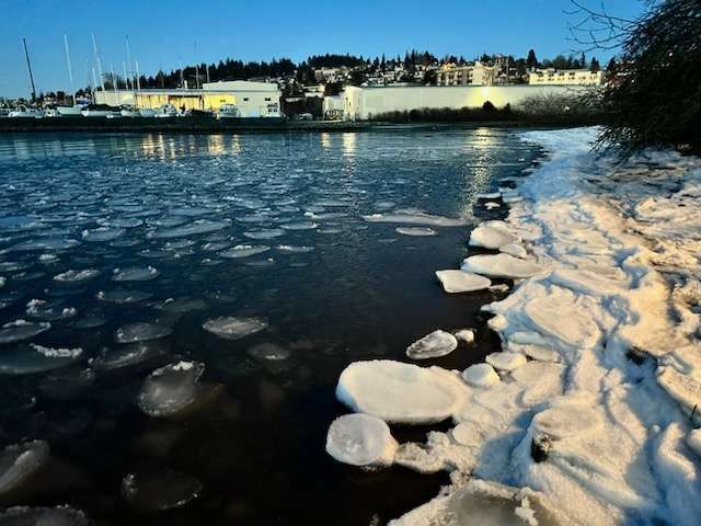

.jpg.0c8d4f5c84c5e42878fcc9203e639685.jpg)
.jpg.f57100e09ea37b09d506103f1d1bfccd.jpg)
- 6999 replies
-
- 21
-

-
January Weather In The PNW 2024 (Part III) - The Warming Shot
Tenochtitlan replied to iFred's topic in West of the Rockies
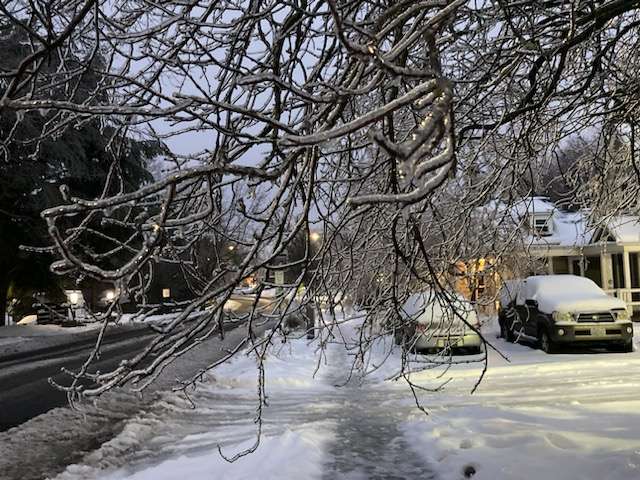
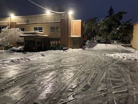
This has been a fun cold snap! I was up in Bellingham for the first few days of it, then back down in Portland for the rest. So unfortunately, I missed both the big snowstorm in Bellingham, and the miniature blizzard that Portland got during the weekend. But I still got to see: Single-digit temperatures for the second time in my life Pancake ice forming in Padden Creek estuary in Bellingham The upper Nooksack River freezing over My first PDX ice storm It's probably the first time I've been really eager for a winter event to be over, since the ice has made it virtually impossible to walk anywhere. I also take public transit and the MAX trains have been mostly shut down. Also the sidewalks have been dangerous down here--not to mention all the fallen trees and branches, and power outages! I will try to post some pictures here later. -
PNW January 2023 Observations and Discussion
Tenochtitlan replied to Requiem's topic in West of the Rockies
February 2019 was ultimately pretty great up here. We mostly missed out on the storms that hit Seattle from the 4th to the 9th, which was frustrating, but then got a couple big storms over the next few days while it was starting to warm up further south. The night of February 12th we got a Vancouver Island convergence zone snowfall that was especially memorable: the flakes must have been the size of half-dollars! -
PNW January 2023 Observations and Discussion
Tenochtitlan replied to Requiem's topic in West of the Rockies
Is the Cali storm a little less wet than forecast? Still though, SFO has seen about an inch and a half of rain so far and high wind criteria have been met there. Their storms seem to usually be more sporadic than ours, with intense bands of heavy rain separated by calm periods. Interesting to check out observations. -
Reno's snowpack has been holding on well. All that wet snow on New Years' must have frozen solid over the past few cold nights, plus they got an inch or two more to keep it fresh. Don't ask me why I'm so enthusiastic about whether it snows in Reno...I'm not sure either other than that I think their cold semi-arid/Mediterranean hybrid climate is quite interesting.
-
PNW January 2023 Observations and Discussion
Tenochtitlan replied to Requiem's topic in West of the Rockies
Meanwhile BLI was slightly colder this December vs. last December, 34.5°F and 34.6°F. -
Looks like Reno got their wettest December day on record yesterday. Super wet snow, 2.26" precip but just 9.0 inches of snow.
-
Reno is getting a big storm today with rain changing to heavy wet snow. It may end up as their 1st or 2nd-wettest December day on record.
-
Wow, the melt here was incredibly dramatic. BLI rose from 33 to 48 in twelve minutes around 6 AM this morning. Almost all the snow is gone now save for the piles and a bit on the grass. I actually like that it ended so suddenly, it makes the event more memorable. It's kind of like we were teleported to Minneapolis for a week and then back to the mild, rainy PNW. BLI eked out a high of 31 yesterday as the cold air held on in the lower levels, so that makes five sub-freezing highs in a row, along with four highs of 17-22 in a row, 8-12 inches of snow, and about a half-inch of ice. The snow came at the perfect time to be able to enjoy it for three very cold days and one more cold day with a regional ice event that would have been much more destructive without the sleet. Definitely one of my favorite weather events of all time!
-
Things still haven't really begun to melt here yet, it dipped back down to 31. In fact, the lull in precip has allowed things to freeze up a bit more. All told there must be at least an inch of liquid equivalent from the snow and ice, so a lot to get through once it warms up (which will be soon).
-
Not really a surprise, but I've found out that an "ice walk" is not as fun as a snow walk. I heard a big tree branch snap, almost fell, and accidentally walked through giant slush puddles. Still a neat experience though!


-
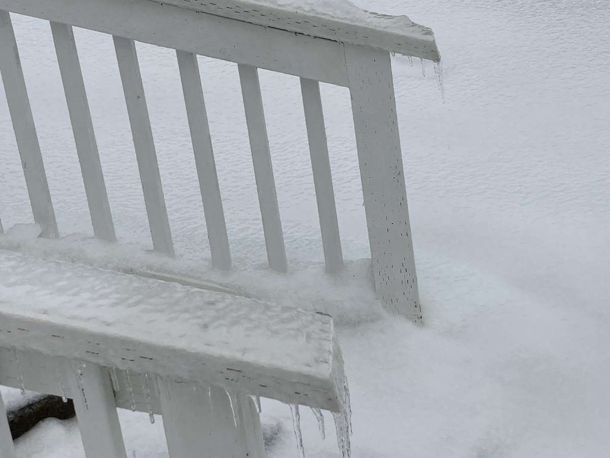
Never really understood the phrase "silver thaw" but after today I get it. It's still a couple degrees below freezing and ice has accumulated some more in general, but there is also lots of standing water and the roads are slushy. Very interesting! We probably have about a third of an inch of ice now and there are icicles forming. All in all this past week is probably my second favorite winter weather event I've experienced in the PNW, after December 2008 in Seattle.


-
I'd have to check to make sure, but I believe this was the coldest 4-day period, in terms of high temperatures, at BLI since December 1990 (slightly beating out last December and December 1996).
-
Spooky weather here. Even though it's 27 there are puddles in some spots, but the snow is covered by about a quarter-inch of ice too. Noticed some trees starting to sag and a small dead plant snapped under its weight while I was walking past.
-
It's sleeting hard out there! It sounds like something's quietly crackling on the stove.
-
Same situation here, down to 19 now.
-
Nice solid trace of new snow on the plowed roads now. Makes things look pretty again.
-
Nice Seattle NWS graphic--very to the point. I do think they should raise ice storm warnings, though. Edit--now it's bothering me that the sign isn't covered in ice. What??
-
If it helps, I think there's like 20% sleet mixed in.
-
Does anyone know what "unknown precipitation" means? Does that mean it's a mixture of frozen precip, or the observer genuinely can't tell what kind is falling?
-
Snowing decently, already starting to coat cleared surfaces again.
-
It seems like winters here have gotten more continental in the last several years compared to, say, ten or fifteen years ago. For example, the annual temperature range last year was 94 degrees for BLI (high of 100 and low of 6) which must be one of the largest of any year on record.
-
It'll be interesting to see how it goes down up here. The GFS is showing equal parts snow and freezing rain but I'm bracing for just ice and maybe some sleet, you know, managing expectations. It's now been at or below 20 for 101 straight hours in downtown Bellingham which is pretty cool (stuck at 20 since 1:30 today).