Tom
-
Posts
27164 -
Joined
-
Last visited
-
Days Won
413
Everything posted by Tom
-
@Hoosier, are you going Lake Effect snow tracking?? This set up looks wild just to your east...
-
12z HRRR...looking prime time for NW IN...ORD will likely surpass the 20" mark for the season with this event.
-

January 2024 Observations and Discussion
Tom replied to Minny_Weather's topic in East of the Rockies
ORD is at 18.1" for the season but will add to this today and tomorrow...what a turnaround and the pattern is ripe for the region to add more before this Historic JAN is over. Some Snow Stats...who thought MSP would struggle this much??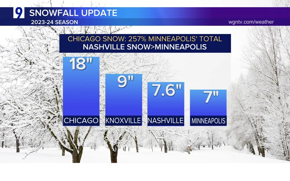
-
Well, well, well...look at what we have here...this is the week where we see the extreme cold departing, but the presence of a Cold Canadian HP still hanging around on the northern end of the Sub will produce wintry precip. Let's add to the Glacier, ay??? 0z GFS for early next week... 0z GFS..pretty darn similar...
-
January 2024 Observations and Discussion
Tom replied to Minny_Weather's topic in East of the Rockies
That’s incredible! It’s like images I remember from the UP of Michigan. -
January 2024 Observations and Discussion
Tom replied to Minny_Weather's topic in East of the Rockies
Took this from LOT's page which they just released a link for the PV visit of 1/14 - 1/17...
-
Where do you live exactly?
-
January 2024 Observations and Discussion
Tom replied to Minny_Weather's topic in East of the Rockies
That's a deep snow depth! Wow, I'm pretty sure you are just admiring the scenery of such a wonderful winter landscape. You've been able to enjoy it for more than a couple weeks, right? Question, did all your snow melt from the Christmas storm before the big snows hit in JAN? -
The Canadians are really good models for clippers or these PAC Hybrid systems. Euro and GFs nasso much! Looks like a nice spread the wealth across the MW into Lower Lakes before the last cold shot this weekend.
-
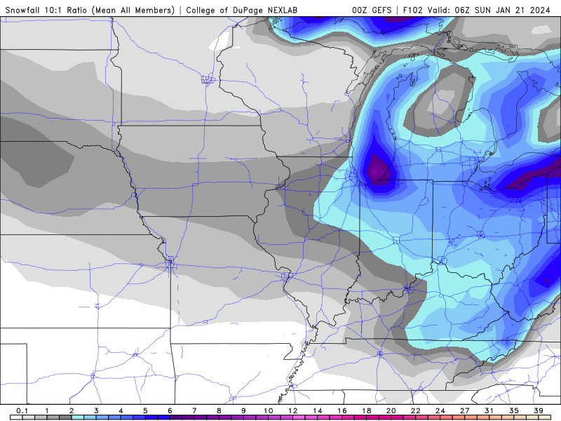
12z HRRR...starting to show a really intriguing Lake Plume into SE WI & NE IL...
-
January 2024 Observations and Discussion
Tom replied to Minny_Weather's topic in East of the Rockies
I'd have to say Chitown "flipped the script"...Top 3 warmest to Top 3 coldest...temps in the 30's next week will feel Balmy...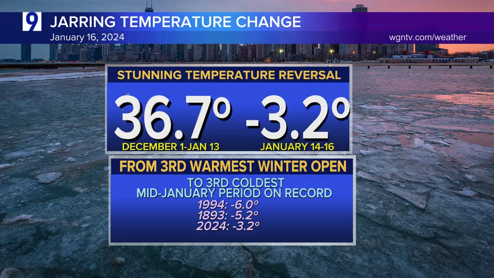
-
Wowza! I haven't read this kinda Lake Effect scenario as long as I've lived in Chicago...man, this could be a hellova period for you guys in NW IN!
-
Gotta love Izzi's wording in his overnight AFD...
-
06z HRRR... @hawkstwelve looking pretty good and into IA...
-
0z/06z NAM really targeting NE IL in NW IN...this setup is looking prime time... @indianajohn @Hoosier @tbone8 This event could and SHOULD make up for lost time!
-
0z Canadian... 0z RDPS...
-
06z GEFS...Lower Lakes looks to be the target as well as the OHV...the Lake Effect signal is robust!
-
January 2024 Observations and Discussion
Tom replied to Minny_Weather's topic in East of the Rockies
Good Ol' Fashion "January Thaw".... -
Do you live anywhere close to the lake?
-
@Jaycee_CHI was living in the Wrigleyville area iirc where it dumped snow.
-
That’s the one! Yes, remember this one vividly…MDW ended up with a lot of snow that winter as they seemed to score more often than not on the Lehs/LES that season.
-
Loved tracking Lehs/LES setups in NE IL and with a very cold airmass in check and the waters have cooled some since the last storm, I would think the lakeside counties can bump up totals a few inches. Heck, I've seen similar situations where that band sits in Cook county and dumps snow before it swings into NW IN.
-
January 2024 Observations and Discussion
Tom replied to Minny_Weather's topic in East of the Rockies
Over the years of tracking these type of systems, I find that the NAM/RGEM and Canadian do the best. The Euro is great with southern stream systems. I’m sure the GFS will come around today. The GEFS showed many members with a decent snow swath. -
January 2024 Observations and Discussion
Tom replied to Minny_Weather's topic in East of the Rockies
#PACHybrid in the works… -
January 2024 Observations and Discussion
Tom replied to Minny_Weather's topic in East of the Rockies
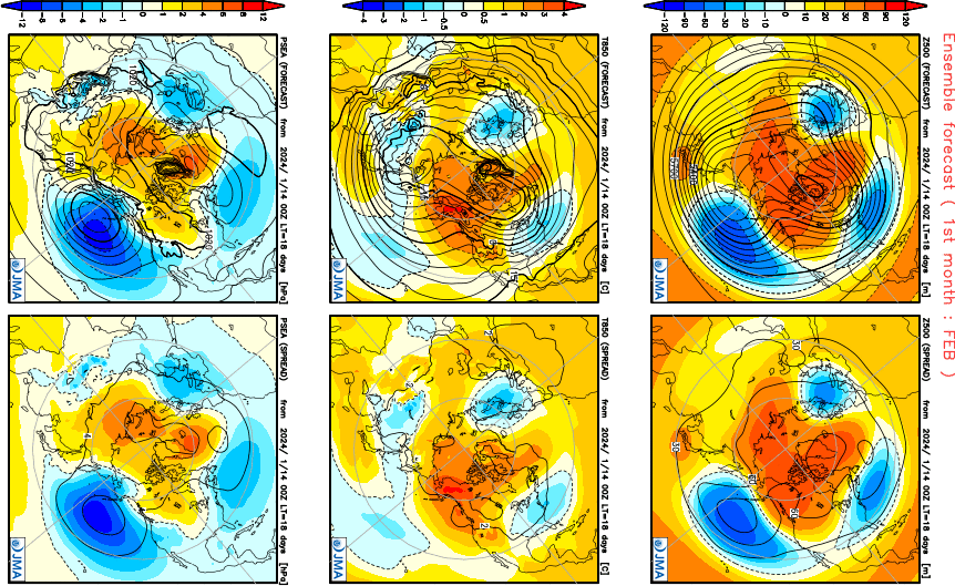
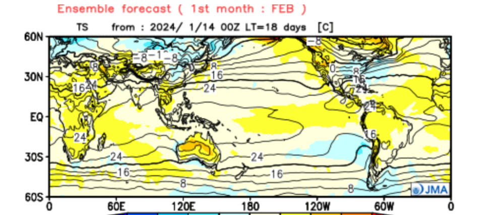
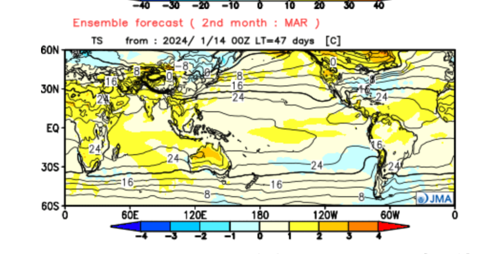
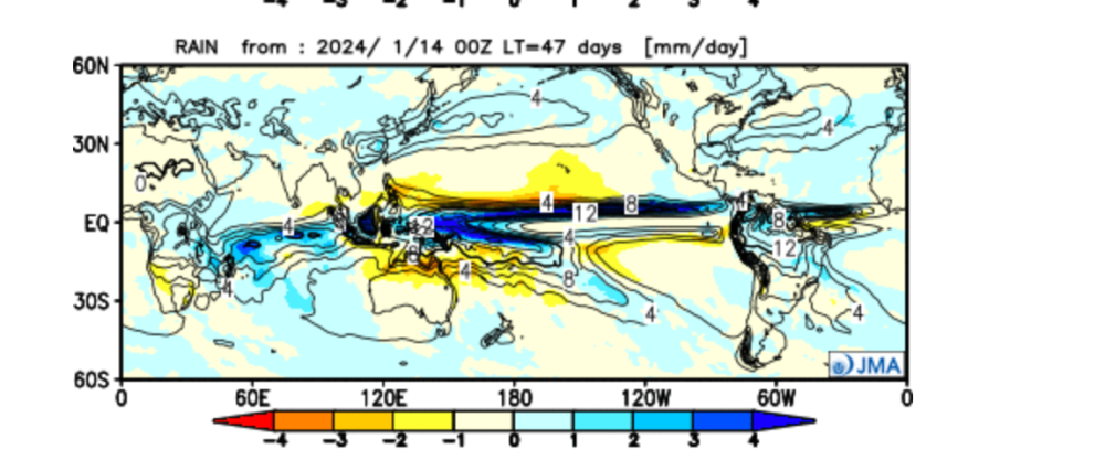
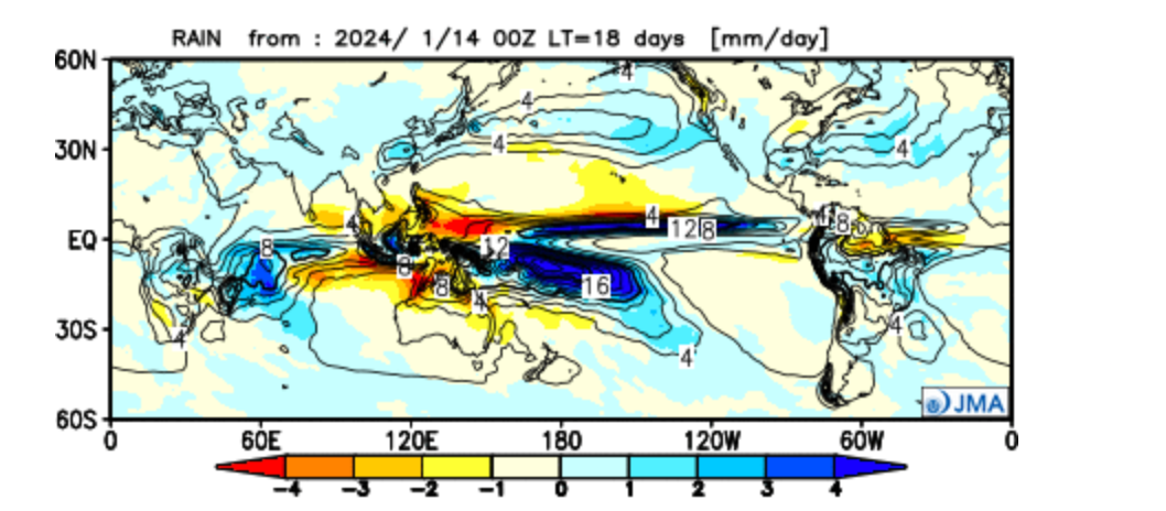
The latest JMA seasonal is steadfast on the cold coming for FEB... COLD and WET...you guys in the south most certainly will not see the last of Old Man Winter! Let's finish it off with MAR... Singing a similar tune but more wetter in the heartland...March coming in like a LION???