


Black Hole
-
Posts
2623 -
Joined
-
Last visited
-
Days Won
1
Everything posted by Black Hole
-
Once again we are looking at multiple days of severe weather potential for many of our members. Starting out Monday, it looks like the potential for a significant outbreak across KS/OK with the potential for giant hail and strong tornadoes. I'll be in OKC this week, so maybe I can get some actual severe weather...or maybe it'll just hit Tulsa and I'll be unlucky lol. The severe weather threat then shifts northeast towards the Ohio Valley for Tuesday-Wednesday. Finally, severe weather may then affect the southeast on Thursday. This looks like another potential doozy, so buckle up!
- 1 reply
-
- 1
-

-
Fine by me! We are getting into the time of the year where it can easily become annoyingly hot. Summer is long enough, every day we can avoid heat is a good day. Hopefully the summer pattern resembles the current one and keeps us closer to or below normal for temps.
-
We will probably need another multi day severe weather thread for the pattern coming next week at some point. Looks like another potential doozy.
-
MCS with embedded MCV (basically a small low) moving into OKC at this hour. It should spread some non-severe storms in here later. Some guidance still showing strong winds developing north of the low later in the night as it weakens.
-

April 2024 Observations and Discussion
Black Hole replied to westMJim's topic in East of the Rockies
Every time I see this stuff I wonder how I tolerated that place for 3 years -
Ended up with another 2.5" of rain last night at my place. Of course I was in the office and we didn't get as much but whatever. Active pattern will support additional storm chances tonight and Thursday but it's more marginal for both severe potential and heavy rain.
-
Late tonight (Tuesday night into Wed) could sneak some storm activity into here. The ECMWF AI model, and some of the MPAS cams are bringing some decent rains overnight.
-
Overall, monthly guidance does seem to indicate an above normal risk of severe weather episodes for the Plains. I do hope to keep the rains going but obviously could do without the violent tornadoes.
-
We will be getting another good soaker Thursday, with some severe potential though probably not a big event. I think areas west of here such as OKC stand a better bet of some severe weather Wednesday as well.
-
We had some additional storms that brought my 24 hour total up to around 3". The airport did better than me at around 3.5" if I am remembering right. There were several tornadoes east and southeast of me, but Tulsa escaped unscathed.
-
2.41" at my place and still coming down although it's probably winding down. No severe weather in town, but there was a strong tornado not too far to the SSW of Tulsa. Some other weaker tornadoes in the general area as well. All in all an interesting event and I am glad storms didn't get any closer. Models are showing another chance this afternoon with some decent instability and enough shear to potentially pop a supercell.
-
For the early afternoon SRH is limited but CAPE is huge. The CAPE is probably overstated given entrainment, but this does certainly support large hail Later in the day the hodograph blows out as the LLJ kicks in. This looks more like a QLCS tornado threat as a presumably linear feature moves in.
-
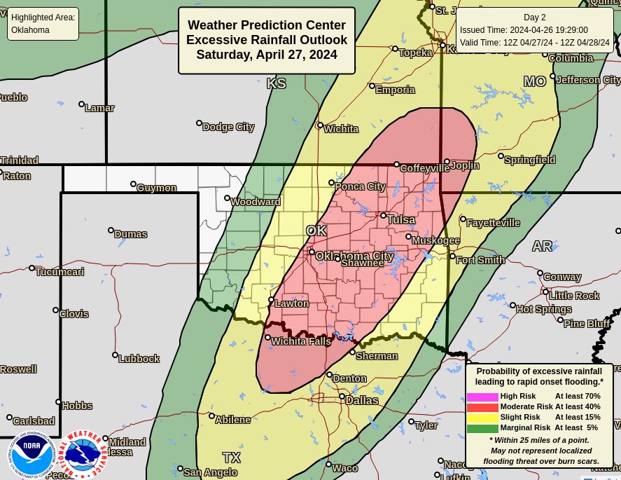
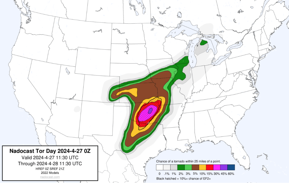
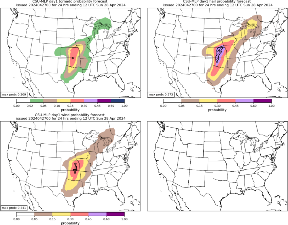
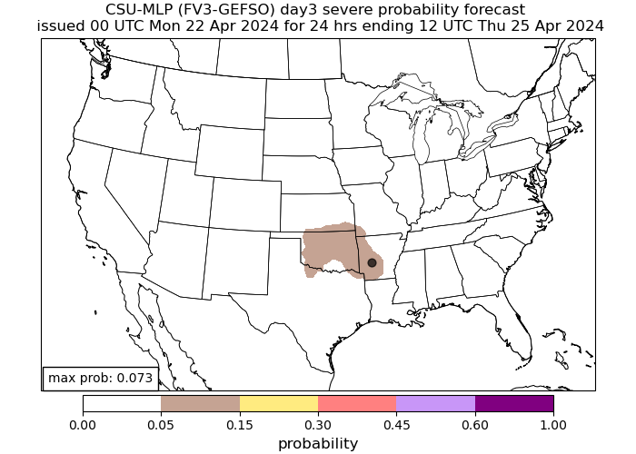
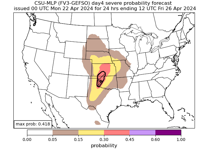
We've got a moderate for severe from SPC and for rain from WPC: Some ML guidance shows the highest threat more towards my area like nadocast: But others like CSU is a bit further west: I'm inclined to think the biggest severe weather threat will be further west towards OKC. I expect to see several strong tornadoes and reports of very large hail. As the storms congeal we will get a wind/QLCS threat morphing into a heavy rain/flood threat overnight. I don't think we will get anything truly crazy, but a couple of inches wouldn't shock me.
-
For my area we are under the slight for today. We will have an initial round of decaying storms this morning near sunrise, with CAMs showing some supercells popping off in the afternoon. There is little agreement on exactly where or when, other than that it will probably happen near or east of Tulsa. So I don't actually expect a lot of activity here today. It looks like a better bet of dry line convection on Saturday afternoon, and this happens in a jacked out parameter space. Still a little early to try to guess exactly what this ends up looking like but the ceiling is high and I expect a moderate to come out on tomorrows outlook for Saturday. Saturday into Sunday either over or just east of me the initially discrete storms merge into a line of heavy rainfall so that is also in the potential mix.
-
It's worth noting that the rainfall forecasts from the NWS are dictated by WPC, not the local offices. Local offices can make changes to WPC for days 1-3 providing they can get their neighboring offices to agree to changes. Additionally, its worth noting that WPC has a chronic high precip bias for amounts over 1" or so. So when you see big rainfall forecasts a few days out, it's probably going to diminish as it gets closer.
-
I know SPC pretty much will only do that for big tornado days. I don't necessary see anything to suggest a high end tornado outbreak just yet, but it's not out of the question either. Don't get me wrong, there will be tornadoes, I'm just not sold on the worst of the worst just yet.
-
This is probably going to be a memorable outbreak for some. Everything is coming together for some big days. SPC just updated their day 3 outlook to add an enhanced. I suspect we get a moderate or two during this stretch.
-
April 2024 Observations and Discussion
Black Hole replied to westMJim's topic in East of the Rockies
My experience says May-September is the intolerable season, and obviously June is the worst since its just sunny and hot. If you go up to Flag or some of the other communities it makes a big difference. -
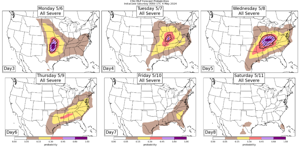
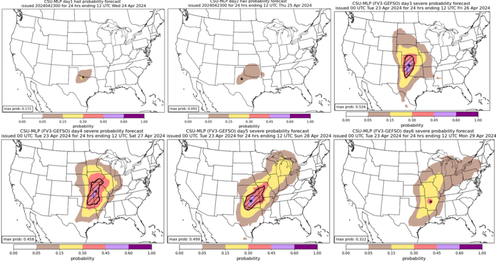
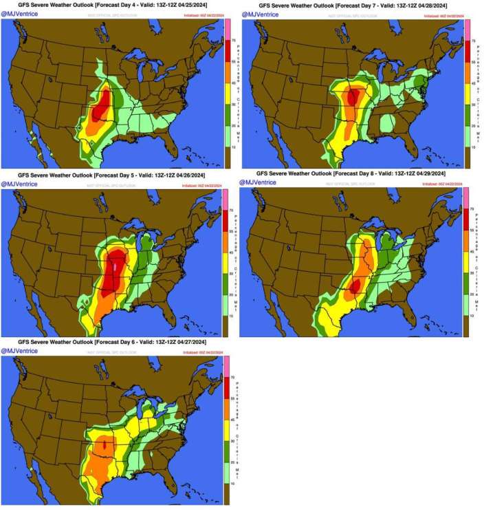
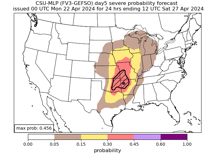
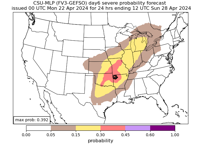
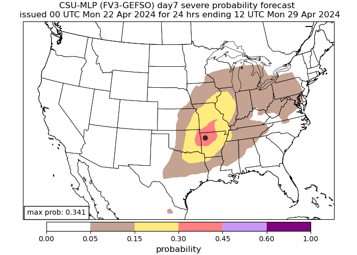
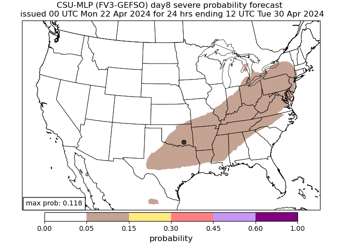
Here is the latest CSU ML severe forecast for the next 6 days.
-
April 2024 Observations and Discussion
Black Hole replied to westMJim's topic in East of the Rockies
Your "100+ season" extends into October so hopefully you can keep up the good mood for the next 6 months lol -
Last spring was boring and dry and this was has shaped up similarly so far, but that looks to change finally! I don't need my house blown away, but a good multi day soaker would really help.
-
From Michael Ventrice using the GFS
-
April 2024 Observations and Discussion
Black Hole replied to westMJim's topic in East of the Rockies
I posted a new thread for the coming multi day severe weather outbreak. -
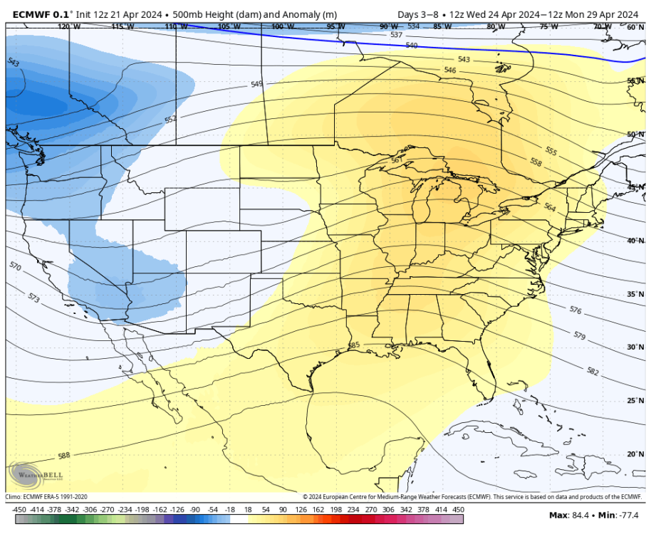
A multi day severe weather outbreak will occur across the southern and central Plains beginning as soon as Wednesday. Persistent troughing west of the area will encourage warm and moist southerly flow with repeated rounds of dry line convection possible. Forecast parameters and pattern recognition show obvious severe potential, potentially significantly severe. It always comes down to the details, but we will have multiple chances for something. For my part of the country, I suspect Friday-Sunday will be our main window but time will tell.
-
https://www.washingtonpost.com/weather/2024/04/17/indonesia-volcano-eruption-ruang/ Paywall, but WP says ash got up to 70k feet. That would probably impact the climate a bit the next 1-3 years. Maybe counteract the warming from the other volcano.


