Hawkeye
-
Posts
7178 -
Joined
-
Last visited
-
Days Won
17
Everything posted by Hawkeye
-
The euro still drops a couple inches on CR on the front end, about half what the UK has.
-

January 2019 Observations and Discussion
Hawkeye replied to Minny_Weather's topic in East of the Rockies
Yeah, a spot of yellow went right over you on radar. The brighter green up here has been moderate to heavy. I had over an inch 20 minutes ago. -
January 2019 Observations and Discussion
Hawkeye replied to Minny_Weather's topic in East of the Rockies
Snow is coming down nicely here. I love good clipper snow. -
Yes, a bit of that is today's snow, but most is the big system.
-
The longer range period has been fluctuating on the models. It had looked pretty mild, but now the GFS only has one day of mild(Groundhog Day), followed by more cold and stormy.
-
UK is actually pretty darn good for CR/IC. It was already the wettest with the front-end thump, but the 12z came a bit back south again.

-
January 2019 Observations and Discussion
Hawkeye replied to Minny_Weather's topic in East of the Rockies
UK and GFS now showing a decent clipper laying a swath of snow through Iowa on Thursday. -
GEM is also a nice front-end thump for CR/IC.
-
January 2019 Observations and Discussion
Hawkeye replied to Minny_Weather's topic in East of the Rockies
The snow started slowly an hour ago, but it has picked up. I may see an inch out of this. -
The low track is way too far north for most of Iowa, but we could still get something. The RGEM has a decent front-end thump and the 3knam has a nice burst of heavy snow along the cold front. It sure would have been great to get another 6-12" on top of the already good snow pack. A deep snow pack is rare here. It's next to impossible to exceed a foot.
-
This system is gradually drifting away from the CR/IC area. The low is getting pushed farther east up in Canada. Iowa needs the low to dive southeast through sw ND, but it's well east of that now.
-
January 2019 Observations and Discussion
Hawkeye replied to Minny_Weather's topic in East of the Rockies
I picked up 0.5" of super fluff this afternoon. -
The trend is certainly not good for the sw 2/3 of Iowa. At this point, I'd gladly take 4 inches.
-
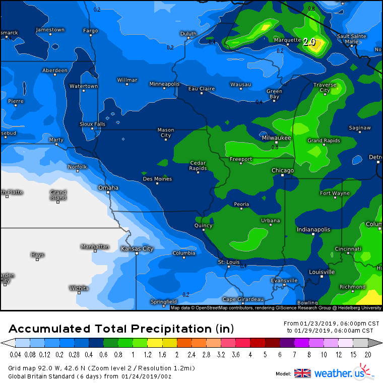
The euro has dropped the system from super clipper to more of an ordinary high end clipper. Except for the weak FV3, the models are darn close this morning. I'll certainly take 5-8 inches of clipper fluff.
-
January 2019 Observations and Discussion
Hawkeye replied to Minny_Weather's topic in East of the Rockies
00z euro - Thursday morning
-
00z euro differences..... tracks more directly southeast toward chicago vs digging south and then east... plus this run is quite a bit weaker with the low (up 10 mb from last night, up several from this morning)
-
00z UK
-
Hold on. The 00z UK is much better than it looks. The 6-hr maps show the surface low diving through Sioux Falls to south-central Iowa, then it pivots and turns ene through Chicago. It still dumps good snow over much of Iowa. The 24-hr maps make it look like the low tracks from Sioux Falls to Chicago. I hate 24-hr maps.
-
Yikes... don't like the GFS/UK at all. I hope they are overdoing the ability of the low to cut across the deep snow pack.
-
12z euro not as sw/extreme as 00z, but still great.
-
As mentioned above, the more west/south it digs, the better for Iowa certainly. That's what last night's euro did, allowing gulf moisture to be pulled in as it turned east. If the snow band simply dives in from the nw it won't be quite as moist.
-
The final burst of heavy snow this morning boosted my total to 4.6 inches. That sounds a lot better than 3.8. My liquid total is 0.44". This stuff is pretty light and fluffy, so a ratio of 10.5 to 1 seems low. As usual, it appears I under-performed/under-measured many locations around Cedar Rapids. Because we got stuck in more dry pockets, there are plenty of 7+" reports well east, south, and west.
-
Boy, this is some pretty heavy stuff.... pound town, 1-2" per hour probably. Radar shows a heavy pocket passing north of the city, but the north wind is blowing it southward as it falls. Radar shows one more nice burst coming, too.
-
I am currently getting the heaviest snow of the entire event. This should push my total to 4 inches. Before this burst I brought my gauge in and melted it down..... only 0.33". Models predicted 0.60".
-
January 2019 Observations and Discussion
Hawkeye replied to Minny_Weather's topic in East of the Rockies
As much as some of these model runs get me excited, the last couple storms are a good reminder that model maps often don't pan out. If models suggest 8-12", expect 6-8". If they suggest 6-8", expect 3-6". Heck, even my conservative expectations haven't been met recently.