Hawkeye
-
Posts
7176 -
Joined
-
Last visited
-
Days Won
17
Everything posted by Hawkeye
-
Light snow/flurries through the day added a small amount to my precip total, putting my storm total at 0.86".
-
Yeah, it's not looking good for our area. The next big storm is going to miss well south and there's nothing on the models beyond that.
-
I picked up 0.81" of rain. A couple hours ago it changed to snow. The flakes were a good size, but it was pretty light, so nothing stuck. Now it's just flurries. This little bit of light snow is the first snow I've seen fall this season.
-
I picked up about 0.40" of rain this morning.
-
My 3.2" of snow so far is above average. The problem is when it fell. If it had fallen during the day and I was able to watch it, it would feel like a decent start to the season.
-
Despite the generally favorable pattern, the start to the winter season is kinda crapping out for some of us unluckies. The first clipper dropped a couple inches, but it was late at night so I didn't see anything. Then, the first big storm totally missed the Des Moines to Cedar Rapids corridor. Now, models are suddenly looking lousy here during the first half of December. The train of snow events on the GFS has vanished. If we get a mild pattern during the second half of December (like 2002), it could be January before I actually see any snow falling.
-
Welcome, Sparky! I was hoping you would find this forum and post your observations from sw of Iowa City. (You probably know I was Dan-CR on Schnack's chat).
-
Congrats to all of you who cashed in. It's tough to watch another 12-17" storm miss north or south of Cedar Rapids. We'll probably struggle to get a 6-8" storm again this winter.
-
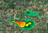
The north edge is crazy sharp. It's hard to believe the snow has stopped in North Liberty, given they are still on the edge of the yellow on radar. There are no reports from Iowa City yet, but the UofI cam suggests at least 2" per hour, as heavy as I've ever seen on that cam. Of course, here in Cedar Rapids we haven't and won't see a single flake.
-
I perked up a bit after seeing the NAM and HRRR taking the decent snow up through the Cedar Rapids metro on last evening's runs, but that was nothing more than a tease. All models are going back south. Radar shows all precip hitting a brick wall just south of Cedar Rapids. We may not get anything at all.
-
Congrats, Chicagoland. It appears I'll be watching this one from the sideline.
-
NAM jumping back south
-
Yeah, the GFS will likely begin sagging south this evening.
-
Well, that's a bummer from the euro.
-
It appears the FV3-GFS is also going to be back north a bit. Over the last day of runs, the Canada upper low dipped noticeably farther south the first couple runs, but the last two it's being pulled back north.
-
We didn't even fall below the low 40s this morning.
-
00z UK
-
That upper low to the north is killing us. The FV3 finally caved and now pokes it much farther south. I hope the models have that feature wrong.
-
Today was the first above avg day this month in Cedar Rapids. We're still trying to melt off the last of the 2.7" of snow that fell last Saturday morning. It's not easy to keep a small amount on the ground for a week in November.
-
Frankly, I think the FV3 is overdoing it a bit. It's very wrapped up with a 989 mb low, several mb lower than the euro. A bit farther south and not as strong is more likely.
-
FV3-GFS still very different than the regular GFS. The FV3 just doesn't have that upper low to the north dipping down into the US like the GFS does, which allows Iowa to get nailed. In fact, the FV3 has moved a bit farther north and misses CR to the nw with the best snow. BTW, my posting will continue to be inconsistent and perhaps sparse because of computer issues.
-
The big upper gyre in southern Canada keeps progressing farther south and east on the GFS, ends up squashing the storm south and east. It would really be something to have three big snow events miss me to the south in November.
-
Yes, it's QPF that falls as snow.
-
12z euro.... This run is quick and south. The quickness doens't allow all the warm air to get pulled up into Iowa, but then that keeps all the precip farther se.
-
North-central Iowa crashed to around -6 degrees this morning. Wow! The Cedar Rapids airport hit 9, while it was about 12 here.