Hawkeye
-
Posts
7178 -
Joined
-
Last visited
-
Days Won
17
Everything posted by Hawkeye
-
12z euro.... This run is quick and south. The quickness doens't allow all the warm air to get pulled up into Iowa, but then that keeps all the precip farther se.
-
North-central Iowa crashed to around -6 degrees this morning. Wow! The Cedar Rapids airport hit 9, while it was about 12 here.
-
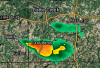
The winners, yesterday, were a couple towns west of Ottumwa, where up to 7.5" fell.
-
There's a report of near 7 inches just west of Ottumwa. Wow, that band really snuck up and overperformed. The NWS was totally caught by surprise.
-
I picked up 2.7 inches from 0.29" liquid. I woke up a couple times overnight and looked out the bedroom window, but the visibility was no big deal so I just went back to sleep. If it's snowing overnight, it needs to be heavy or I just don't care anymore.
-
The 20z HRRR had a 0.50" strip through CR. However, the last three runs have dried out a fair amount. The latest is down to about 0.30".
-
Two local mets are keeping the better snow along and north of Waterloo-Dubuque. One of them still has Cedar Rapids in the T-1" band. The other, Terry Swails, has the good band a little farther south, with 2-4 reaching down to near CR. He said given the latest model data, he would extend the advisory farther south if he was in charge.
-
18z GFS continues the southward sag.
-
Welcome, BMT! I wish the guy from southwest Johnson county would join us as well. Dang... the latest HRRR is super juiced, has a 0.50" strip through CR.
-
DVN is expanding the advisory, but only down to Waterloo/Dubuque. They must be skeptical of the farther south snow placement.
-
Yeah, it's getting more interesting for the CR area. The HRRR is showing some pretty good snow rates from 2-5am.
-
I see the nws is pretty unexcited about this system for anyone outside of northeast Iowa. DVN has
-
12z GFS is south. I may end up with an inch or two from this. I hate that it's from midnight to sunrise, though.
-
The NAM seems to be on its own. The timing looks to be mostly before sunrise, so yet another night snowfall.
-
It seems like it shouldn't be that difficult to get a single inch of snow during early Novermber. However, my records show that yesterday's half inch of snow in Cedar Rapids is the ONLY measurable snow we've had during the November 1-10 period over the last twelve years(I began keeping track in 2007).
-
Yeah, a lot of arctic cold with little to show for it.
-
Most of our half inch is gone already, despite the temp in the upper 20s.
-
That's the band the euro had moving through my area for several runs, but was totally wrong.
-
I picked up a half inch. Looking at the radar loop, it appears much of that fell in one burst around 6am. I was still sleeping, though.
-

Your All-time favorite winter storms list
Hawkeye replied to jaster220's topic in East of the Rockies
I have two problems. First, there just haven't been many memorable snowfalls here. I've never measured a foot. Second, my memory sucks. Even thought I'm a weather geek, I just don't remember many events from long ago. It seems like many other weather geeks remember everything, as far back as their childhood. One obvious choice for memorable snowstorm is the Groundhog Day blizzard. The brunt just missed me to the southeast, but I received about 10 inches and of course got the strong wind. That was the worst driveway drifting I've ever experienced.- 93 replies
-
- 2
-

-
- Snowstorms
- Blizzards
- (and 1 more)
-
I'm only expecting a dusting here, maybe a tenth or two. I'm not going to bother waking up in the middle of the night to watch.
-
The 00z GFS has moved the Friday clipper sw, so the GEM and Euro are the only two models bringing snow through eastern Iowa.
-
We're still sitting at 33, by far the coldest day so far. As Bud just posted, the 12z euro remove any snow for our area from the first wave. The possible potent little clipper behind it is still a mystery. The euro and GFS still have it crossing my area, but other models don't... and the swath of snow is so narrrow, any one location can easily be missed.
-
The euro takes the main wave of snow south of my area, but then it has a clipper that lays down a narrow swath of snow nw-se through eastern Iowa.
-
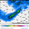
I picked up 1.33" from this system. I never saw any downpours. It was basically 16 hours of mostly light to occasionally moderate rain. The models may have dropped the late-week snow system for Iowa, but the cold is still there. Today's 12z euro even extended the cold through day ten, showing nothing but 20s and 30s.