

Brian_in_Leavenworth
-
Posts
3545 -
Joined
-
Last visited
-
Days Won
7
Everything posted by Brian_in_Leavenworth
-

January 2019 Weather in the Pacific Northwest
Brian_in_Leavenworth replied to Requiem's topic in West of the Rockies
Ask the people in North Puget Sound if they had any interesting weather. I am sure they will respond, that is if they have had their power restored after the biggest windstorm in more than 10 years. But it is an El Nino year, whether it becomes official or not, so you can't realistically expect anything that interesting. -
January 2019 Weather in the Pacific Northwest
Brian_in_Leavenworth replied to Requiem's topic in West of the Rockies
Mark Nelsen posted about that, and commented that "We’ll see, seems like models have been trying to develop these big highs too often this winter, backing off as we get closer." On the other hand, it is about the time of year during an El Nino winter that the big ridge takes over the PNW. I hope not though. -
January 2019 Weather in the Pacific Northwest
Brian_in_Leavenworth replied to Requiem's topic in West of the Rockies
The one image of the Euro weeklies that I saw from last night showed the huge ridge right over the PNW, delivering the cold air over the east, just like a typical Nino. That was for late January/early February. -
January 2019 Weather in the Pacific Northwest
Brian_in_Leavenworth replied to Requiem's topic in West of the Rockies
Highway 20 is better travelling East to West, BTW. -
January 2019 Weather in the Pacific Northwest
Brian_in_Leavenworth replied to Requiem's topic in West of the Rockies
A few years ago they had a gust of 137mph, with 14 straight hours with gusts over 90. This is at the top above the ski area, though sometimes they close the lifts due to high winds. -
January 2019 Weather in the Pacific Northwest
Brian_in_Leavenworth replied to Requiem's topic in West of the Rockies
Yeah, 95% of the time it doesn't, and regardless of whether or not the El Nino is "official", it has sure been acting like that, and it makes it even less likely. Every long range Euro run so far has all the cold air east. But nothing is impossible. -
January 2019 Weather in the Pacific Northwest
Brian_in_Leavenworth replied to Requiem's topic in West of the Rockies
I have seen a lot of debate about that. I know there are definitions for an "official" El Nino, and definitions for El Nino "Conditions", and like Phil said, different datasets yield different SST anomalies. And of course you also have the MEI way of defining El Nino. But as far as the actual weather, it does seem like this has acted like an El Nino. Warm, often splitty systems, California getting a lot of precip, etc. Even though places in the PNW have been wet, that is not unusual for early Winter for the PNW in an El Nino winter. I don't think nature cares how we define it, I think it "defines" El Nino by the actual weather. -
January 2019 Weather in the Pacific Northwest
Brian_in_Leavenworth replied to Requiem's topic in West of the Rockies
Ryan Maue says it has not been better than the GFS and that the Euro has been improving, so the American models have been falling further behind. Also the Canadian model has done a lot better since their upgrade. -
January 2019 Weather in the Pacific Northwest
Brian_in_Leavenworth replied to Requiem's topic in West of the Rockies
I think the nicer and newer neighborhoods might be South of 90. The few times we have been have bee in that area. Also in that area is the beautiful Manito Park Another nice feature of Spokane is Couer D' Alene and Silverwood are not far away, and Sandpoint is not much further than that. -
January 2019 Weather in the Pacific Northwest
Brian_in_Leavenworth replied to Requiem's topic in West of the Rockies
You also find that you don't always post abour your snow because you don't want people to think that you are bragging and you realize many people wont get any snow this winter. Nor will you complain about "only" getting 4 inches of snow instead of 8 inches of snow when many people would be thrilled with 2 inches. But I will say we have had at least 5 inches today with 2-4 more coming.
-
January 2019 Weather in the Pacific Northwest
Brian_in_Leavenworth replied to Requiem's topic in West of the Rockies
It had a lot of effect on our winter weather. Not so much in the overall patterns, but it definitely warmed up the systems that came into the NW. 2013 was a very rare year without a white Christmas in Leavenworth. I would read the AFD's from Spokane, and time after time after time the systems came in way warmer than the models and what the 500mb pattern would have predicted. The meteorologists in Spokane had to adjust their temps upward by several degrees after they realized what was going on. They mentioned the blob quite a few times. In the overall scheme of things, not a big deal, but several degrees difference in temps made a huge difference in the sensible weather. -
Good article with a short documentary about January 1950, and it even has some color video from 1950. All from Tacoma. https://tacomahistory.live/2019/01/07/unforeseen/
-
January 2019 Weather in the Pacific Northwest
Brian_in_Leavenworth replied to Requiem's topic in West of the Rockies
I remember when my dad died, the taps and salute were very emotional. The gal playing taps was at a bit of a distance, and that added to the affect. My mom had already passed, so I got the flag. That was an incredible honor for me. They gave condolences "On behalf of a grateful nation". We are all grateful for you fathers' service to our country. -
January 2019 Weather in the Pacific Northwest
Brian_in_Leavenworth replied to Requiem's topic in West of the Rockies
It has been warm, and ridging usually doesn't dominate until mid to late January. El Ninos are often very wet the first part of winter. It was in 2015. -
January 2019 Weather in the Pacific Northwest
Brian_in_Leavenworth replied to Requiem's topic in West of the Rockies
I don't. It is an El Nino year, after all. Doesn't make it impossible though, just highly unlikely. And a huge ridge over us in mid to late January is classic El Nino. -
January 2019 Weather in the Pacific Northwest
Brian_in_Leavenworth replied to Requiem's topic in West of the Rockies
Go to this site, select 1 1/3 km, and look for your area. https://atmos.washington.edu/wrfrt/gfsinit.html -
January 2019 Weather in the Pacific Northwest
Brian_in_Leavenworth replied to Requiem's topic in West of the Rockies
Jay Albrecht @AlbrechtJay 50s50 seconds ago MoreThis map and prev tweeted map of 40mph gusts to 60 mph in Seattle Tacoma area peaking 3-5 AM looks very close to the official NWS forecast! -
January 2019 Weather in the Pacific Northwest
Brian_in_Leavenworth replied to Requiem's topic in West of the Rockies
Jay Albrecht @AlbrechtJay 2m2 minutes ago Moreand here is 1.33 km UW WRF for 4 AM. Winds are peaked here with inflow through the Strait of Juan de Fuca getting really strong. -
January 2019 Weather in the Pacific Northwest
Brian_in_Leavenworth replied to Requiem's topic in West of the Rockies
NWS SeattleVerified account @NWSSeattle 2m2 minutes ago MoreHere's the track of the surface low pressure over the past few hours based on surface observations from airports, buoys, and ships. Best estimate for maximum wind timing in Seattle metro right now - rapidly rising after 2 AM and peaking around 4 AM. #wawx (not sure how to show the GIF, but the point is the time estimate for Seattle). https://twitter.com/NWSSeattle/status/1081788037586186240 -
January 2019 Weather in the Pacific Northwest
Brian_in_Leavenworth replied to Requiem's topic in West of the Rockies
NWS SeattleVerified account @NWSSeattleFollow Follow @NWSSeattleMoreA little science into why the wind burst will be sudden/strong overnight. It's not just the track & depth of the surface low that matters. A sudden rise in pressure occurs behind it. Rate of change of pressure on a map is called an "isallobar" & 4+ millibars in a hour is hefty. -
January 2019 Weather in the Pacific Northwest
Brian_in_Leavenworth replied to Requiem's topic in West of the Rockies
Jay Albrecht @AlbrechtJay 30m30 minutes ago MoreYep! Up there this one looks much less of an issue. I'm watching the area from San Fran to Portland OR as prime damage territory with this one with the storm decaying nicely as it moves northward. Still a pretty windy night here in Seattle! 0 replies 0 retweets 1 like ReplyRetweet Like1 -
January 2019 Weather in the Pacific Northwest
Brian_in_Leavenworth replied to Requiem's topic in West of the Rockies
Jay Albrecht @AlbrechtJay 15m15 minutes ago MoreJay Albrecht Retweeted Rebecca Stevenson Cliff is hitting it hard -saying it is the worst to hit Seattle this year. I think that we have had similar if not stronger winds back in December. Major is possible - but appears to be near the top of the envelope. -
January 2019 Weather in the Pacific Northwest
Brian_in_Leavenworth replied to Requiem's topic in West of the Rockies
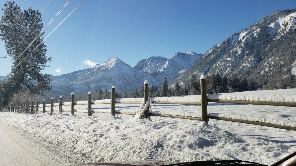
And yesterday the pass was closed for a good part of the day. That happens several times every winter. We then get all the traffic through Leavenworth that I-90 would get, plus the regular US2 traffic. -
January 2019 Weather in the Pacific Northwest
Brian_in_Leavenworth replied to Requiem's topic in West of the Rockies
I have talked to some very old timers here, who will talk about their parents and grandparents saying that they had winters that were either very snowy, or very warm. Some winters it did not snow at all, and it was so warm they did not have to wear coats during winter. Not sure how far back that goes, probably more than 100 years, -
January 2019 Weather in the Pacific Northwest
Brian_in_Leavenworth replied to Requiem's topic in West of the Rockies
They are. Read their AFD. Scroll down to Portland's AFD https://www.atmos.washington.edu/data/disc_report.html

