

Brian_in_Leavenworth
-
Posts
3545 -
Joined
-
Last visited
-
Days Won
7
Everything posted by Brian_in_Leavenworth
-

January 2019 Weather in the Pacific Northwest
Brian_in_Leavenworth replied to Requiem's topic in West of the Rockies
Interesting tweets from Dr. Ryan Maeu about the models Ryan MaueVerified account @RyanMaue 3h3 hours ago MoreGlobal weather model rankings for the last year (5 day forecasts) ECMWF UKMET NOAA GFS CANADIAN Recent GFS poor skill is surprising -- unsure of reason. And another tweet where he responds to questions: Ryan MaueVerified account @RyanMaue 3h3 hours ago MoreThe designated upgrade to GFS called FV3 has so far shown little skill gains. Thus, another year has gone by with NOAA's global weather model skill languishing. Check back in 2020 to see how FV3 performed ... "upgrade" coming in Feb (?) with gov't shutdown. Brian Etherton @briane678 3h3 hours ago More Copy link to TweetEmbed Tweet Replying to @RyanMaue Given your data, the result seems to be: once NOAA switches from the GFS core to the FV3 core, they will still be in 3rd place, behind ECMWF and UKMO. True? 1 reply 0 retweets 0 likes Reply 1 Retweet Retweeted Like Liked Ryan MaueVerified account @RyanMaue 2h2 hours ago More Copy link to TweetEmbed Tweet Replying to @briane678 Based upon the last 180-days, the skill scores are the same. Meanwhile, ECMWF has gotten better, so GFS falls further behind by default. 1 reply 0 retweets 1 like Reply 1 Retweet Retweeted Like 1 Liked 1 Brian Etherton @briane678 1h1 hour ago More Copy link to TweetEmbed Tweet Replying to @RyanMaue ...in addition to falling further behind ECMWF, and staying behind UKMO, seems we're quite close to falling behind Canada? 1 reply 0 retweets 0 likes Reply 1 Retweet Retweeted Like Liked Ryan MaueVerified account @RyanMaue 1h1 hour ago More Copy link to TweetEmbed Tweet Replying to @briane678 Canada has improved significantly over past 6 months since their last major upgrade. GFS skill debate is interesting but having an antiquated ensemble system like GEFS is more concerning. -
January 2019 Weather in the Pacific Northwest
Brian_in_Leavenworth replied to Requiem's topic in West of the Rockies
I do. There has already been a lot of splitting systems this year, and it is an El Nino winter. -
January 2019 Weather in the Pacific Northwest
Brian_in_Leavenworth replied to Requiem's topic in West of the Rockies
I guess it depends on how he defines winter. If he thinks winter for the next couple of months is just the same crap weather, then I can understand. I used to live in Western Washington, and you do get tired of the weather when there is no hope for snow. -
January 2019 Weather in the Pacific Northwest
Brian_in_Leavenworth replied to Requiem's topic in West of the Rockies
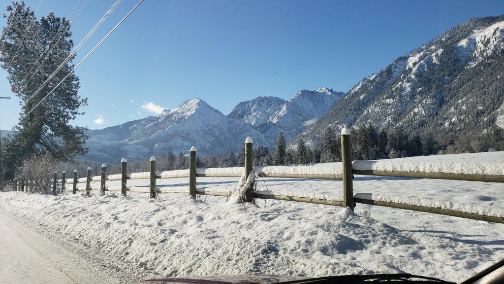
Mt. Baker ski area once closed for two days because of too much snow. Took them that long to dig out. Almost 20 feet fell in one two week stretch. https://snowboarding.transworld.net/photos/the-winter-of-9899-baker-gets-too-much-of-a-good-thing/ -
January 2019 Weather in the Pacific Northwest
Brian_in_Leavenworth replied to Requiem's topic in West of the Rockies
The ECMWF weeklies from last night showed above normal temps for just about the entire Northern Tier of states and Canada to the Great Lakes, and below normal precip for the NW including BC. The weeks after that look to be "normal" https://weatherloverblog.wordpress.com/2019/01/04/jan-3-euro-weeklies/ -
January 2019 Weather in the Pacific Northwest
Brian_in_Leavenworth replied to Requiem's topic in West of the Rockies
Both sound fascinating. I hope you are able to pursue one of these. Dont wait until you are too old to pursue these dreams. -
January 2019 Weather in the Pacific Northwest
Brian_in_Leavenworth replied to Requiem's topic in West of the Rockies
Lots of good maps here goes to hour 180: (only for the 12Z and 0Z) https://atmos.washington.edu/mm5rt/extendedgfsinit.html -
January 2019 Weather in the Pacific Northwest
Brian_in_Leavenworth replied to Requiem's topic in West of the Rockies
Are you interested in a career in meteorology? Or testing instruments? Seriously, it sounds like Mt. Washington, NH would be a dream place for. Wind lover like you. Even if just an internship. If you have that much of a passion for wind storms and weather, maybe you should seriously pursue it. https://www.mountwashington.org/research-and-product-testing/ -
January 2019 Weather in the Pacific Northwest
Brian_in_Leavenworth replied to Requiem's topic in West of the Rockies
Here is a tweet from Jay Albrecht, from the NWS. Jay sometimes posts on here as Jaya Jay Albrecht @AlbrechtJay 4m4 minutes ago MoreWell, courtesy of http://TropicalTidbits.com , here is a fcst sounding for Bremerton next Tue AM. Warm front with low level NE flow. Counting on heavy precip, isothermal near 0C boundary layer, and evap cooling. Marginal. UW WRF goes nuts with snowfall. I'm skeptical. #wawx #wasnow -
January 2019 Weather in the Pacific Northwest
Brian_in_Leavenworth replied to Requiem's topic in West of the Rockies
On another note, snowstorm at the OK Corral! https://www.facebook.com/historictombstone/videos/516805308810822/ -
January 2019 Weather in the Pacific Northwest
Brian_in_Leavenworth replied to Requiem's topic in West of the Rockies
Spokane AFD thinks it is odd that the GFS cools the atmosphere before that system early next week because the storm is coming from the South. -
January 2019 Weather in the Pacific Northwest
Brian_in_Leavenworth replied to Requiem's topic in West of the Rockies
Especially in the longer range. Maybe because of resolution or maybe too much qpf? Many times you or Tim have posted the 240 hour snowfall maps, and from my location, it looks like we get absolutely buried. Not that we don't get snow, we average 94 inches every year, but usually what happens is that as events get closer, the snow totals go down. -
January 2019 Weather in the Pacific Northwest
Brian_in_Leavenworth replied to Requiem's topic in West of the Rockies
There wasn't any real snow yesterday either. The total snow maps are always an illusion, very low resolution on those, that is why the NWS never uses those. At most a few places in the hills would have had a couple of hours of mixed precipitation before temps warmed up rapidly. I live in snow country, and have learned not to take total snow maps seriously. There have been times when it has showed my area with 30 inches or more of snow when 4-6 inches is more realistic. -
January 2019 Weather in the Pacific Northwest
Brian_in_Leavenworth replied to Requiem's topic in West of the Rockies
Yesterday that same hour was showing mixed rain and snow for some areas of Puget Sound. Much warmer with this run. -
January 2019 Weather in the Pacific Northwest
Brian_in_Leavenworth replied to Requiem's topic in West of the Rockies
It was already cold, for a few days it looked like there was going to be a major region wide snowfall, and then maybe another one after that, the biggest one in decades. But the storm tracked north and brought warm weather behind it instead, so the snow was brief. A huge, bitter bust for all of us. -
January 2019 Weather in the Pacific Northwest
Brian_in_Leavenworth replied to Requiem's topic in West of the Rockies
I think people in British Columbia, Skagit County, and Whatcom County who went days and weeks without power, lost all their food, had their Christmas ruined, etc. will gladly give you their next wind storm. -
January 2019 Weather in the Pacific Northwest
Brian_in_Leavenworth replied to Requiem's topic in West of the Rockies
Day 15 Ensemble model DISagreement! Roll the dice. -
January 2019 Weather in the Pacific Northwest
Brian_in_Leavenworth replied to Requiem's topic in West of the Rockies
With a southerly flow and snow levels rising to 6000 feet, whatever snow wouldn't last for very long at all. -
January 2019 Weather in the Pacific Northwest
Brian_in_Leavenworth replied to Requiem's topic in West of the Rockies
Actually looking at "Total Snowfall" maps and taking them seriously is under thinking things. People have been left with the impression that the Euro shows a major snowfall for Puget Sound when in fact it does not. -
January 2019 Weather in the Pacific Northwest
Brian_in_Leavenworth replied to Requiem's topic in West of the Rockies
Good for you. Have fun exploring the region, including Coeur D Alene, Mt. Spokane, and you are closer to Northeast Washington. Oh, and if you and anyone else in your family likes gardens and flowers, you have to go to Manito Park. -
January 2019 Weather in the Pacific Northwest
Brian_in_Leavenworth replied to Requiem's topic in West of the Rockies
Looks awesome until you look closer at the models. I went to Weather.us, and looked at that time frame. It never shows pure snow anywhere in the Sound during that time (Tuesday). During the time when the alleged snow is supposed to fall, especially in the South Sound, the temps are above freezing and the "significant weather" shows rain. Earlier the "significant weather" showed mixed rain and snow with temps in the mid-30's. So the "total snow fall" is a computer glitch, not representative of what the model actually shows. -
January 2019 Weather in the Pacific Northwest
Brian_in_Leavenworth replied to Requiem's topic in West of the Rockies
Euro weeklies had us at or above normal temps until the last week of January. -
December 2018 Weather in the Pacific Northwest
Brian_in_Leavenworth replied to Tyler Mode's topic in West of the Rockies
This is interesting. I don't buy it, the resolution is probably too low, but something for North Sound people to keep an eye on. This is precip in inches that falls as snow. This would mean Whatcom County and Bellingham would be buried IF it verified.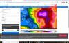
-
December 2018 Weather in the Pacific Northwest
Brian_in_Leavenworth replied to Tyler Mode's topic in West of the Rockies
And a closeup of the North Sound. Temp gradients are not believable (I used to live there). Sure, I-5 is cooler than the water, but can't believe that Mt. Vernon area would be almost than 20 degrees colder than the Anacortes area, and also colder than the Cascades to the East of Mt. Vernon.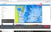
-
December 2018 Weather in the Pacific Northwest
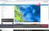
Brian_in_Leavenworth replied to Tyler Mode's topic in West of the Rockies
Thursday 1/10 ar 4AM it shows temps in the 30's along Puget Sound. Upper 20's inland


