gabel23
-
Posts
2304 -
Joined
-
Last visited
-
Days Won
5
Everything posted by gabel23
-
Late on the reply but wow Tom; this might be one of the most impressive radar displays I have seen in a long time! I have never seen that amount of CG's from one storm even out here in the plains! Hoping we get lucky tonight before another heat wave this weekend.

-
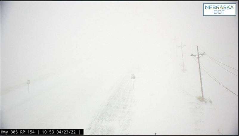
While we deal with the heat and humidity here's what's going on in Montana! Insane! URGENT - WINTER WEATHER MESSAGE National Weather Service Missoula MT 1102 AM MDT Mon Jun 13 2022 MTZ002-141800- /O.CON.KMSO.WS.W.0009.220614T0000Z-220615T1200Z/ West Glacier Region- 1102 AM MDT Mon Jun 13 2022 ...WINTER STORM WARNING REMAINS IN EFFECT FROM 6 PM THIS EVENING TO 6 AM MDT WEDNESDAY ABOVE 5000 FEET... * WHAT...Heavy snow expected above 5000 feet. Total snow accumulations of 3 to 8 inches above 5000 feet...including Marias Pass. Above 6000 feet, snow accumulations of 8 to 15 inches with up to 2 feet above 7000 feet. Winds gusting as high as 45 mph, especially on the ridgetops. * WHERE...West Glacier Region. * WHEN...From 6 PM this evening to 6 AM MDT Wednesday. Clouds have been hanging around my area pretty much all morning. I'm fine if we don't make it to 100 I"m going golfing!
-
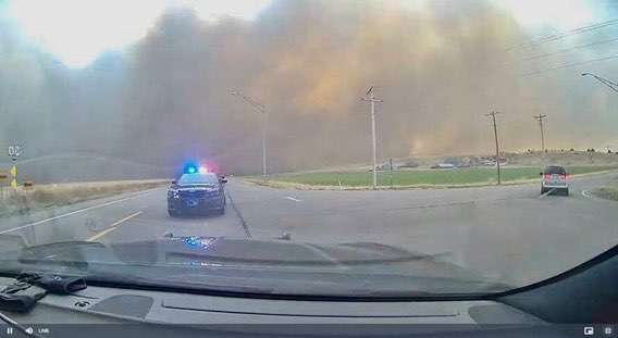
It was absolutely insane last night! Never in a million years did I think I would experience a Haboob! After I recorded the following video things just went completely black as midnight. Multiple trees where uprooted and gonna need quiet a bit of clean up today.
- 666 replies
-
- 11
-

-

-

April 27th- May 9th | Tornado Outbreak Sequence
gabel23 replied to Iceresistance's topic in East of the Rockies
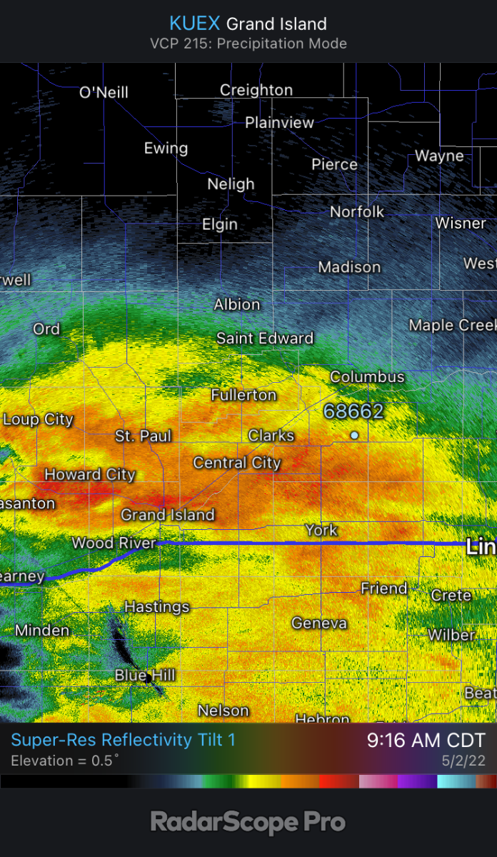
I have been home for 30 minutes and the temp has dropped from 39 to 36. I have 1.8" of rain so far and some fat snow flakes are starting to mix in. Radar doing a pretty good job of picking that up. Just a crazy week so far. IMG_1756.MOV
-
We are currently mixing in fat snow flakes in my area with the rain! Sitting at 1.8" for the day and now we top it off with some snow on May 2nd!!!
-
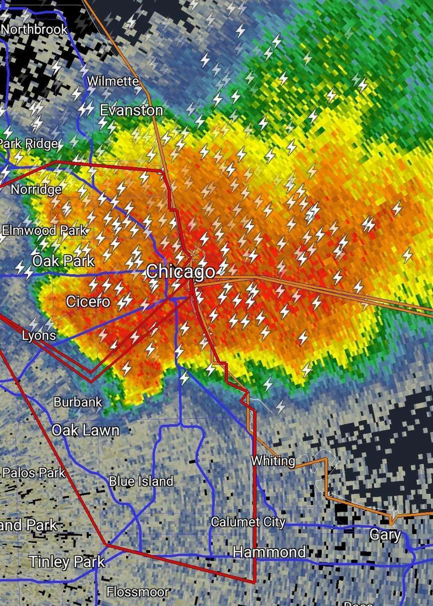
I haven't seen a radar image like this for my area in a long time. Big time reflective activity showing up. It's almost like the radar is seeing a mixed bag yet temps aren't anywhere close to it. It's absolutely pouring out there for sure. We are certainly closing in on a drought busting two weeks!

-
April 27th- May 9th | Tornado Outbreak Sequence
gabel23 replied to Iceresistance's topic in East of the Rockies
Just a wonderful soaking the past couple of days! My county was in a tornado warning last night as the squall line rolled through. I of course went out chasing and went too far west. I ended up being overtaken by the line and couldn't get back out in front. The shelf cloud was impressive but again I went too far west to watch it roll in! I received .90" on Thursday and 1.7" the past 48 hours so a total of 2.6. My lawn care business will be kicking into high gear as we roll into May! The gardening on the other hand will have to be delayed for a while..... -
April 27th- May 9th | Tornado Outbreak Sequence
gabel23 replied to Iceresistance's topic in East of the Rockies
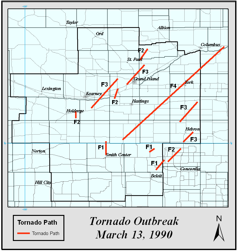
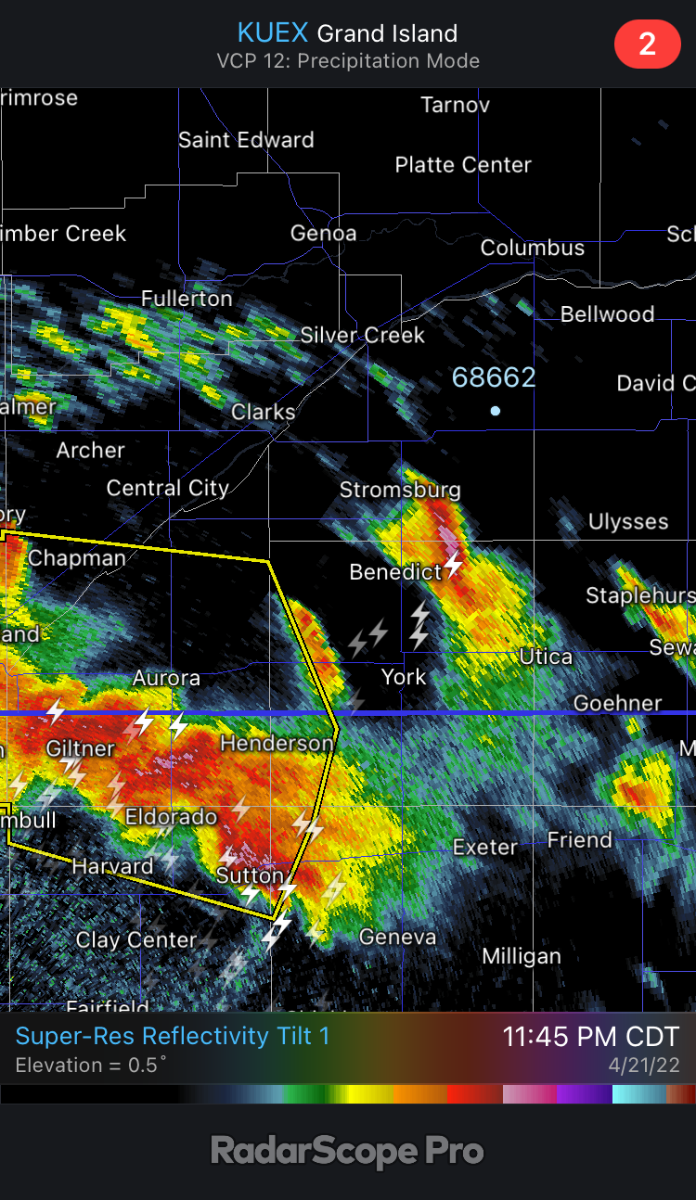
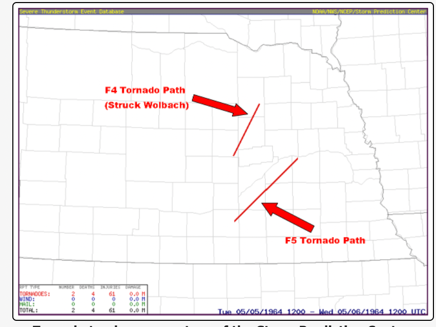
Not saying it's gonna happen but that cell matches up very well with where two of the strongest tornadoes happened in Nebraska history. Jim Flowers also showed a similar path in his video today with what was shown in the models.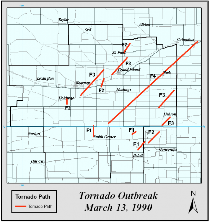
-
April 27th- May 9th | Tornado Outbreak Sequence
gabel23 replied to Iceresistance's topic in East of the Rockies
Sun is out here. Gonna be an interesting day for sure; I'm anxious to see if storms can stay discrete in my neck of the woods. -
Then meanwhile on the other end of the state while we fight fires......
-
Structure fire has spread into fields north and east of town. Winds are just howling which of course doesn't help the situation..... IMG_1741.MOV IMG_1740.MOV
-
No way stopping this.
-
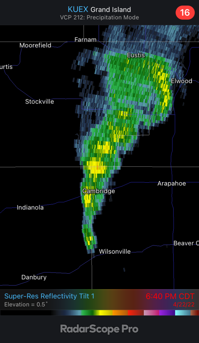
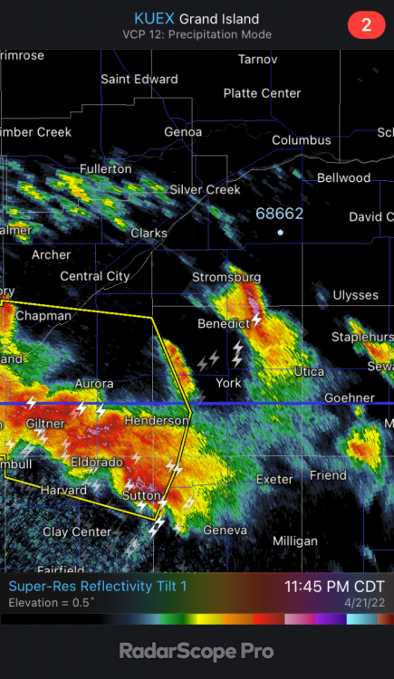
@CentralNebWeather yet again another major going on. Just insane. Cambridge just missed but Bartley and Indianola being evacuated. Here it is on radar an hour ago! Radar down in Hastings.

-
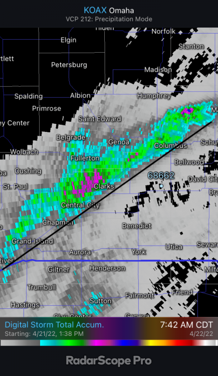
I have a folder of images, snow reports, rain reports and radar images from the past 5 years and it's crazy how well they line up with that river! I'm hoping tonights storms can hold together and march east and give us all a little something.
-
Shocker, the storms rode the river and stayed to the north of it. I ended up with .15". Reports of 1-3" of rain match up pretty nicely with the radar. The black line is the platte river; the evidence I'm gathering is remarkable with how that dang platte river plays a large part in the direction of storms.
-
Currently 60° with a 61% relative humidity reading. It would be pretty disappointing if I don’t get something out of this line of storms moving off to the north east…
-
April 2022 Observations & Discussions
gabel23 replied to Iceresistance's topic in East of the Rockies
.04 in my digital gauge!! -
April 2022 Observations & Discussions
gabel23 replied to Iceresistance's topic in East of the Rockies
Just another blowing dust advisory for our area! We started softball tonight and it was not fun. Between the blowing dust in the air and the blowing dust on the field we were caked in dirt. Give us a break already….. -
April 10th - 15th Extremely dynamic storm system
gabel23 replied to Iceresistance's topic in East of the Rockies
The dry line pushed through my area earlier than storms where able to develop. Made it up to 90 today. What happened after the dry line blew through was something I have never seen. Winds switched to the west/northwest and blowing dust blew through. I went out 2 miles to our east and visibility was a half mile or so. There was also a major accident 5 miles to the north on highway 81. I stayed on the country roads but it was clear that highway was not a place you wanted to be on. Welcome to the dust bowl 2022. IMG_1721.MOV- 236 replies
-
- 10
-
-

-
-
April 10th - 15th Extremely dynamic storm system
gabel23 replied to Iceresistance's topic in East of the Rockies
Actually might be blowing dust after all being picked up. BLOWING DUST ADVISORY NWS HASTINGS NE 328 PM CDT TUE APR 12 2022 KSZ006-007-018-019-NEZ039>041-046>049-061>064-074>077-084>087-130000- /O.EXA.KGID.DU.Y.0004.000000T0000Z-220413T0000Z/ 328 PM CDT TUE APR 12 2022 Smith KS-Jewell KS-Osborne KS-Mitchell KS-Valley NE-Greeley NE-Nance NE-Sherman NE-Howard NE-Merrick NE-Polk NE-Buffalo NE-Hall NE-Hamilton NE-York NE-Kearney NE-Adams NE-Clay NE-Fillmore NE-Franklin NE-Webster NE-Nuckolls NE-Thayer NE- ...BLOWING DUST ADVISORY IN EFFECT UNTIL 7 PM CDT THIS EVENING... * WHAT...Visibility between one quarter mile and one mile in blowing dust. * WHERE...Portions of north central Kansas and central, east central and south central Nebraska. * WHEN...Until 7 PM CDT this evening. * IMPACTS...Hazardous driving conditions due to reduced visibility. * ADDITIONAL DETAILS...A plume of blowing dust has been moving from southwest to northeast across the eastern part of the Hastings forecast area this afternoon with several reports of lowered visibility. Southwesterly winds ahead of a cold front will shift to the northwest over the next few hours. This will push the dust from northwest to southeast. Be prepared for rapidly changing visibility due to blowing dust. -
April 10th - 15th Extremely dynamic storm system
gabel23 replied to Iceresistance's topic in East of the Rockies
Figured it was that or a darn Haboob forming!!! We made it up to 88 so far, will see if storms fire before the dryline pushes through my area. -
April 10th - 15th Extremely dynamic storm system
gabel23 replied to Iceresistance's topic in East of the Rockies
I'm assuming this is the dry line showing up on the radar??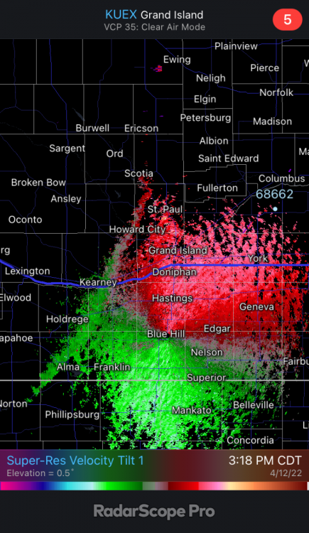
-
April 2022 Observations & Discussions
gabel23 replied to Iceresistance's topic in East of the Rockies
Same here, I have my yard treated, sprinklers and everything. Yard looks just like that. It also didn't help with all the foot traffic all over my yard! I'm very concerned this could be a bad year in the mowing department for me. -
April 2022 Observations & Discussions
gabel23 replied to Iceresistance's topic in East of the Rockies
I have a mowing business also and I haven’t started on one single yard. To me things won’t be ready to be mowed for at least a couple weeks. Last year at this time I was mowing last week already! -
April 10th - 15th Extremely dynamic storm system
gabel23 replied to Iceresistance's topic in East of the Rockies
Boy this is going to be quite the storm for North Dakota, as been the case all winter. URGENT - WINTER WEATHER MESSAGE National Weather Service Bismarck ND 231 PM CDT Sat Apr 9 2022 NDZ002>005-009>013-017>023-031>036-040>046-100345- /O.NEW.KBIS.WS.A.0003.220412T1200Z-220414T1200Z/ Burke-Renville-Bottineau-Rolette-Williams-Mountrail-Ward-McHenry- Pierce-McKenzie-Dunn-Mercer-Oliver-McLean-Sheridan-Wells-Golden Valley-Billings-Stark-Morton-Burleigh-Kidder-Slope-Hettinger- Grant-Bowman-Adams-Sioux-Emmons- Including the cities of Parshall, Hettinger, Fessenden, Wilton, Marmarth, Glenburn, Dunseith, Sherwood, Killdeer, Tappen, Dickinson, Minot, Mcclusky, Mandan, Beach, New Leipzig, New Town, Watford City, Columbus, Solen, Shell Valley, Hazen, New England, Underwood, St. John, Bismarck, Portal, Lignite, Harvey, Beulah, Rugby, Center, Bowman, Rolette, Selfridge, Drake, Towner, Velva, Linton, Mohall, Garrison, Medora, Washburn, Bowbells, Carson, Elgin, Fort Yates, Halliday, Goodrich, Steele, Rolla, Mott, Strasburg, Powers Lake, Stanley, Williston, Turtle Lake, and Bottineau 231 PM CDT Sat Apr 9 2022 /131 PM MDT Sat Apr 9 2022/ ...WINTER STORM WATCH IN EFFECT FROM TUESDAY MORNING THROUGH THURSDAY MORNING... * WHAT...Heavy snow and blizzard conditions possible. Total snow accumulations between 10 and 20 inches possible. Winds could gust as high as 40 mph. * WHERE...Most of western and central North Dakota. * WHEN...From Tuesday morning through Thursday morning.