gabel23
-
Posts
2306 -
Joined
-
Last visited
-
Days Won
5
Everything posted by gabel23
-
Even though this storm has trended north for a couple days now......my grid still only has 3-7" of snow even though my low end on all models is 6" and max is 16"! WTF?!
-
It was the one furthest south all week now it’s the one furthest north?! Ha, crazy it now pretty much matches up with all the models. My Grid has a mix and 3-8 yet all models show 8+. Obviously the NWS know way more than us but sometimes I wonder how they do what they do!
-
Been a very long time since we have seen probabilities this high holy smokes. Record breaking for some areas if it comes to fruition.
-
Thanks Tom!!! Wow the snow shield for the state has really expanded! Bring on a back loaded winter baby! PS. Smoking some ribs and poor man's burnt ends and will be routing on my Buffalo Bills! We have a layer of ice from last night's snow/drizzle throw on the snow we are about to receive and things are gonna be slick as heck.
-
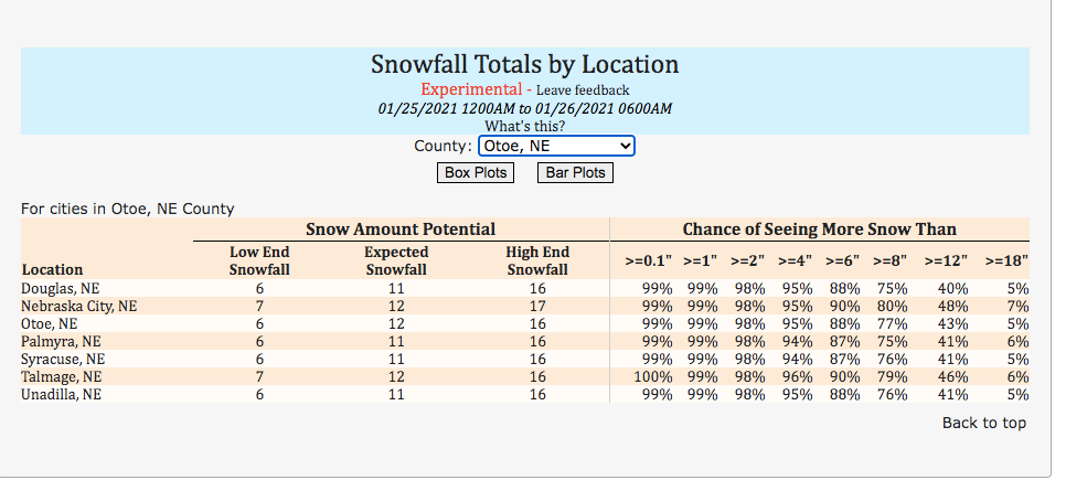
You wanna post this for our area too Tom when you get a chance?
-
Ouch I hope the nam is smoking something.... that would hurt my area.
-
Ok with the euro the only major model left and with it being as consistent as it has been; I would be shocked if the watch and or eventual warning doesn’t get nudged north. Gonna be an interesting afd in the morning for the weather offices.
-
Most models; although the 18z Euro took a step to my south, has me getting 6+. Yet Hastings NWS is going with the GFS and have me getting 1-4". I don't get it but we shall see. It sucks I really want the snow but yet we have conference tournament week and this will really throw a wrench into that!
-
-
@Tom or anyone else who can answer this question......is there a way to access the old web site that we used to have? I would like to access the discussions we had form 10 or so years ago!! I don't know if they are archived or if there is another way to view the discussions.
-
Insane gradient setting up. If the low aligns just right, seward and a few counties to the west could get into the fun including my area. Even an inch of snow with these winds will be a major problem. I seen it a month ago with the previous blizzard.
-
Blizzard warning now only a couple counties away.......crazy how insane the cut off is to the west. Good luck to all, I seen a blizzard with only 2" of snow back in December. Can't imagine what you guys in Iowa are gonna experience!! URGENT - WINTER WEATHER MESSAGE National Weather Service Omaha/Valley NE 249 PM CST Thu Jan 14 2021 ...Blizzard conditions expected tonight and Friday... NEZ043-051-066-090-092-150600- /O.EXA.KOAX.BZ.W.0001.210115T0600Z-210116T0000Z/ Colfax-Saunders-Lancaster-Johnson-Pawnee- Including the cities of Schuyler, Wahoo, Ashland, Yutan, Lincoln, Tecumseh, Sterling, Pawnee City, and Table Rock 249 PM CST Thu Jan 14 2021 ...BLIZZARD WARNING IN EFFECT FROM MIDNIGHT TONIGHT TO 6 PM CST FRIDAY... * WHAT...Blizzard conditions expected. Total snow accumulations of up to two inches. Winds gusting as high as 60 mph. * WHERE...Colfax, Saunders, Lancaster, Johnson and Pawnee Counties. * WHEN...From midnight tonight to 6 PM CST Friday. * IMPACTS...Difficult to impossible travel due to near zero visibility and roads becoming snow covered. The Friday morning and evening commutes will be heavily impacted. Power outages and tree damage are also possible.
-
Finished with 6” of snow and now at 15” for the year! Half way to my seasonal total just in the month of December!
-
I don’t either. That extends back and then into my county. 4-6 to my north and south. 2-4 then splitting my county. You would think the warning gets expanded west from omaha and that gap fills.
-
Radar looks impressive around your area, any report?! That band looks impressive.
-
Hastings mentioned this morning expect some changes, will see if those warnings get expanded. temperatures, both at the surface and aloft will have a large impact on snow and ice accumulations. With the uncertainty in the forecast, there could be significant changes to the current forecast as the time comes closer for this system.
-
Can you show the wider view if you would please?
-
Might be the earliest I seen Hastings put something out.... then consider the uncertainty with the models. I would take it though and run! https://www.weather.gov/media/gid/sitreport/SitReport1.pdf
-
Long live the king euro!!
-
The Euro is a bit to the northwest. Areas along and north of the platte river should do fine with this run. Man this is gonna be one heck of a battle. The one agreement with the models...the gulf will be wide open so we should see plenty of moisture in one form or the other. Gonna ride with the Euro until it proves me wrong. It's done really well for me so far this year.
-
No kidding! I wish we could get a west East slider so everyone can get into the action! I’m sitting pretty good but lots of time for this to change.
-
Very similar.....maybe a little more north?
-
If the EURO shows what the GFS does today I'll be concerned. Until then, all my faith is in the king EURO!
-

DECEMBER 23-26 Potential storm for SW Great Lakes
gabel23 replied to kush61's topic in East of the Rockies
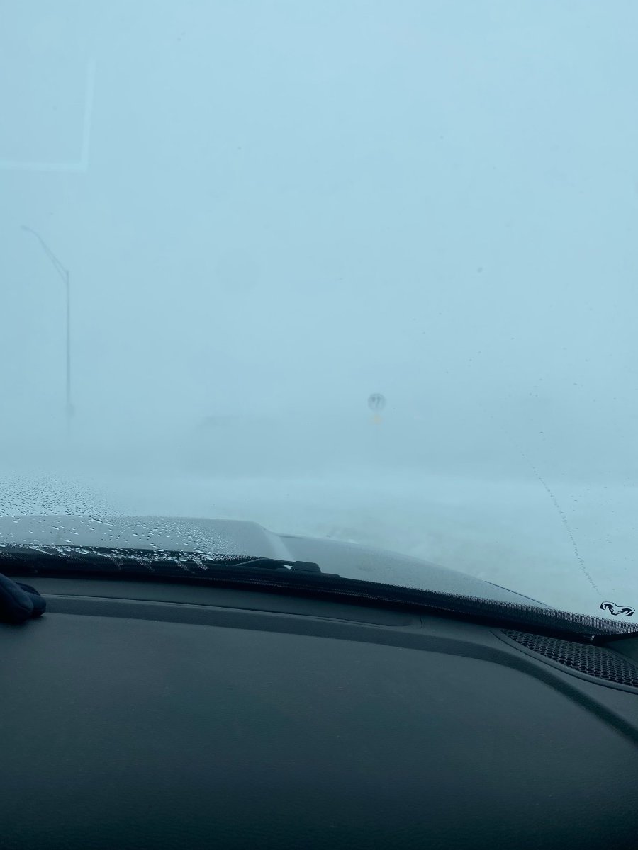
The most intense drive I have ever been apart of. Needed to take my family to the in-laws 20 miles away. Well we have a 3 mile stretch out of town that is treeless and open land for miles. Visibility was zero that whole stretch and had to pull off. Luckily for us the gravel roads was much easier sledding… This is me parked at the 3 mile corner. There were cars and cops parked on the median and you cant see the lights!
-
OAX might be getting excited about next week. Looking far ahead to next week, models remain consistent in showing another very strong winter storm Tuesday through Thursday. This storm system has the potential for very heavy snow and strong winds. Much more to come on this next big winter storm in the coming days.