Snowshoe
-
Posts
658 -
Joined
-
Last visited
-
Days Won
1
Everything posted by Snowshoe
-
Jan 18th-20th Potential Winter Storm. Can this be The One??
Snowshoe replied to jaster220's topic in East of the Rockies
Love the 1.9 in central Wisco but would be surprised to see it. Just enough to cover the grass is all i ask for. Happy for all the forum peeps down south that will cash in! Post pics to remind me what snow looks like. -
January 2019 Observations and Discussion
Snowshoe replied to Minny_Weather's topic in East of the Rockies
-
January 2019 Observations and Discussion
Snowshoe replied to Minny_Weather's topic in East of the Rockies
Got excited when my phone buzzed me displaying a winter weather advisory. Then I quickly remembered it wasn't going to snow. Yeah more frz drz. -
Jan 18th-20th Potential Winter Storm. Can this be The One??
Snowshoe replied to jaster220's topic in East of the Rockies
Looks like i'm sitting this storm out yet again. Winter better not show up in April like it did last year! -
January 2019 Observations and Discussion
Snowshoe replied to Minny_Weather's topic in East of the Rockies
I'm a little concerned the northern 2/3s of Wisco will be some of the upset ones. -
January 2019 Observations and Discussion
Snowshoe replied to Minny_Weather's topic in East of the Rockies
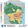
To give you an idea how unusual this winter is. The town of Minocqua in northern Wisconsin is warning people of unsafe ice. The unsafe lake mentioned is extremely popular for snowmobilers and normally freezes solid for vehicle travel by Christmas. Very unusual to have this problem at all much less into January. https://www.townofminocqua.org/lake-minocqua-remains-unsafe-and-unmarked/ -
January 2019 Observations and Discussion
Snowshoe replied to Minny_Weather's topic in East of the Rockies
What a mess this morning. There's about an inch of semisolid liquid on the driveway. Currently pouring rain and mid 30s. Absolute worst weather imaginable. -
Riding the northern edge. Not sure what to expect. Could see flurries on up to 4".
-
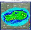
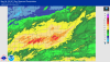
Talk about having to thread the needle. Pretty small bullseye over Green Bay.
-
December 2018 Observations and Discussion
Snowshoe replied to Minny_Weather's topic in East of the Rockies
December is going to end up being about 5° warmer than avg. and roughly normal (.91") liquid equiv. precip. What will be memorable to me is the really long dry spell from 12/3 to 12/25. I would usually associate dry spells with cold canadian air but not this year. Hopeful for a better January. -
December 2018 Observations and Discussion
Snowshoe replied to Minny_Weather's topic in East of the Rockies
Does pull down a massive high pressure -
December 2018 Observations and Discussion
Snowshoe replied to Minny_Weather's topic in East of the Rockies
A healthy below normal bullseye around Lake Superior is interesting to me. Maybe the model doesn't consider lake effect snow? Or maybe the model doesn't see much in the way of N-NW winds? -
December 2018 Observations and Discussion
Snowshoe replied to Minny_Weather's topic in East of the Rockies
Something tells me by next Tuesday i'll be rooting for the NW trend again after days of moving SE -
December 2018 Observations and Discussion
Snowshoe replied to Minny_Weather's topic in East of the Rockies
Boy you ain't kidding! There's not even enough snow in the lake effect belts of northern Wisconsin to get the snowmobile trails open. Losing out on Christmas and potentially New Year's business would be a severe blow to many places up there. Snow should be much closer to the 24 by this time of year. http://www.snowsnakes.net/camera/videoold.jpg -
December 2018 Observations and Discussion
Snowshoe replied to Minny_Weather's topic in East of the Rockies
Was a decent start to winter. Not looking forward to the warm temps but a little sun will be nice. These foggy mornings are really starting to wear me down!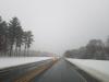
-
December 2018 Observations and Discussion
Snowshoe replied to Minny_Weather's topic in East of the Rockies
Sad that i feel the need to report such meager snowfall but.... well here we are. -
December 2018 Observations and Discussion
Snowshoe replied to Minny_Weather's topic in East of the Rockies
WWA issued for up to an inch of snow and -
12/01 - 12/02 Winter Rain / Snow Storm
Snowshoe replied to East Dubzz's topic in East of the Rockies
Truly don't know what to think. My gut says warm air wins on Saturday and I end up with maybe 2" of slush by late Sunday. -
My drive home from Milwaukee Sunday will be fun. Better make sure i've got plenty of podcasts loaded up! I'm sure traffic will be awesome.
-
PERFECT sleeping weather last night! NIce steady rain all night long. Radar estimates around 2" last night and 3-4" over the last 7 days.
-
Used to live in Kenosha and there was nothing worse than an east wind off the lake. I miss the big lake but glad I moved inland.
-
Tried to leave mine off overnight and woke up to a cold house and an even colder wife!
-
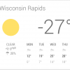
Funny how quickly the low 50's seem cold! It is 10o below average but compared to 30's it should feel warm.
-
All this talk about planting season and green grass has me a little jealous. Lakes in C. Wis are still iced over and reports of 24-30" of ice on lakes up north is common. The strong sun and hopefully a warm t-storm along the way gives me hope for open water for the fishing opener May 5th. Parts of NE Wis could see a bit of light snow Friday morning but otherwise it looks like an end (FINALLY!!!) to winter! April was historic for sure. Magnified in my mind due to a lackluster snow season IMBY. More snow in April than DJFM combined. Crazy. https://www.weather.gov/grb/RecordAprilSnowfallForMost Here is a list of the monthly snowfall totals through April 22nd andhow it ranks as the snowiest April on record. Most locations acrossnorth-central and northeast Wisconsin have smashed the previoussnowiest April on record. An amazing 45.3 inches of snow has fallenat Tigerton in Shawano County while 44.0 inches has fallen atSturgeon Bay. These totals are not a state record for the month ofApril. In 2013, an observer near Bayfield recorded 47.4 inches ofsnow for the month while 47.0 inches was recorded at the Brule RangerStation.Some locations on this list do not have a historical record or have avery short period of record. For these sites, NA was used for the oldrecord. The snowfall amounts below are preliminary based on what hasbeen reported so far. The numbers may change as additional data becomesavailable. April 2018 Current or Old RecordLocation Snowfall Rank Amount Year-----------------------------------------------------------------Tigerton 45.3 NASturgeon Bay 44.0 1st 13.5 1909Peshtigo 43.5 1st 9.5 1996Oconto - 4W 41.9 1st 17.0 1907Shawano - 2SW 41.5 1st 16.1 1928Shiocton 38.2 NAPulaski 37.1 NAWashington Island 36.9 1st 15.5 1996Green Bay (NWS) 36.7 1st 15.1 1907Green Bay (Botanical) 36.5 NASister Bay 36.5 NASuamico - 4WNW 35.2 NAMerrill - 7W 34.6 NAWausau 34.5 1st 25.5 1909Ephraim - 1NE 34.2 NAClintonville 33.6 1st 16.0 1977Land O` Lakes 33.2 NAWhite Lake 33.1 NAGreen Bay - 4SSE 33.1 NAMarinette 32.4 1st 13.0 1977Forestville - 4E 32.1 NANew London 31.8 2nd 32.0 1907Schofield 31.1 NAStevens Point 30.9 1st 19.0 1928Appleton 30.8 1st 26.0 1907Summit Lake 30.7 1st 26.6 2002Suring 30.7 1st 13.0 1993Kaukauna 30.0 NAFlorence 29.5 1st 21.6 2008Marshfield 28.0 1st 17.0 1928Wisc. Rapids 27.9 1st 22.6 1977Rhinelander 27.8 2nd 28.1 2014Mountain 27.7 NAAntigo 26.6 1st 20.0 1928Stratford - 1NW 24.2 1st 22.4 1965Argonne - 2MW 24.2 1st 23.0 2014Menasha 24.2 NABrillion 24.0 1st 15.6 1928Eagle River 23.3 1st 22.9 2014Two Rivers 18.5 1st 12.5 1973Chilton 18.0 2nd 18.5 1909Oshkosh 16.8 1st 11.0 1910Manitowoc 13.3 3rd 18.5 1907
-
April 13th-16th Spring Bowling Ball Powerhouse
Snowshoe replied to Tom's topic in East of the Rockies
3.43" estimated liquid between the rain, sleet, snow. Hoping for a gradual melt.