
Jesse
-
Posts
44769 -
Joined
-
Last visited
-
Days Won
325
Everything posted by Jesse
-
Mark's 7-Day (he made a new blog post tonight too):
-
You are calling for temps 5-10 degrees warmer than they will really be across the board.
-
I like you.
-

February 2014, non-sun angle affected, Arctic forecast contest
Jesse replied to Deweydog's topic in West of the Rockies
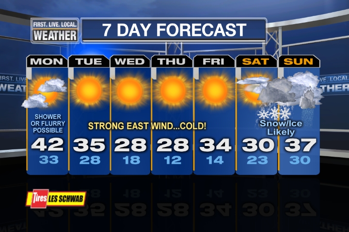
PDX: Tue- 39/25 Wed- 30/21 Thu- 28/18 Fri- 32/14 Sat-31/19 (snow late) SEA: Downright summerlike at Tim's house. He will be BBQing and the kiddie pool will be out. Stevenson: Tue-35/24 Wed-27/19 Thu-24/17 Fri-26/16 Sat-28/18 (snow late) -
So you're basically saying all the models are wrong?
-
February 2014, non-sun angle affected, Arctic forecast contest
Jesse replied to Deweydog's topic in West of the Rockies
What made you go so ridiculously warm? -
So weird how the operational GFS has been a warm outlier with every run. Basically the mean and all the other ensembles look uniform and are colder. I would assume the ensemble mean ends up correct since the colder temps are supported by every other model.
-
Radar echos starting to move into the Portland area.
-
Looks like it was 38/32 out in Stevenson today. Chilly.
-
Pendleton reporting snow now. Some snowcover in the basin going into this could really help keep gorge outflow locations frigid Wed-Fri. I am in Tigard with my girlfriend's family today. We just got back from a walk at Cooper Mountain Nature park before the game. There are some interesting clouds out, with towering cumulus over the Cascades. Almost looks like a summer t-storm pattern. The north wind really was picking up too, and it felt chilly and dry. I think the next few days could definitely hold some surprises.
-
Not so sure about that. Most people agree Andrew has been kind of a pill the last month or so. I love the guy, but it is what it is. Probably due to not nearly enough snow at his location this winter so far.
-
Why did you change your name from Pedro771? I figured if you did anything you would make it deweydog2. I don't see what's wrong with trying to avoid conflict and increase the overall positivity of my forum experience.
-
I think the groundhog is going to see his shadow today.
-
Maybe we are beginning a new era.
-
Alright. Well you just keep on trying to dig up stats that show how run of the mill and boring this event will be. I am going to try to enjoy it for what it is, and if I am using this forum I think the best way for me to enjoy it is to simply ignore your posts from now on.
-
As Justin said yesterday, if PDX can pull off four consecutive highs below freezing (looking possible) this event will be almost unrivaled as far as duration this late in the season. The only bigger one would be 1936. I don't understand how on earth anyone could downplay the significance of that.
-
Find another cold wave the second week of February that rivals how this one is looking. Just about as top tier as you can get for this time of year.
-
I don't understand why everyone is downplaying the CAA for this event. Outflow looks to be raging. Mark Nelsen mentioned that the offshore flow will be strong enough to blow over the Cascades, giving almost everyone in the I-5 corridor east winds.
-
Same for down here. 850mb temps peak around 0c on the mean then make their way back down toward -5c. I could see my location getting buried if this trend of undercutting further south and keeping offshore flow around for longer continues.
-
Where does the 12Z Canadian bottom us out at?
-
Good point, I probably went too cold.
-
Wow, the operational is STILL on the warm side! Definite potential for this to go even colder. If PDX verifies at -17c it will be their coldest blast since December 1990.
-
Ok, just making sure you weren't still buying into the GFS MOS or whatever it is that shows us with low-mid 40s all week.
-
Loving the trend on the Canadian for next weekend.
-
Just on Saturday? Pretty sure their record min/maxes of 34, 38 and 39 on Wed-Fri have a pretty good shot as well. Especially Thursday and Friday.