


Clinton
-
Posts
6522 -
Joined
-
Last visited
-
Days Won
28
Everything posted by Clinton
-

January 14-16 Major Winter Storm and Arctic Blast
Clinton replied to Black Hole's topic in East of the Rockies
12z GFS drier up north which makes since with how cold it will be. Adding 2nd wave -
January 14-16 Major Winter Storm and Arctic Blast
Clinton replied to Black Hole's topic in East of the Rockies
12z ICON is putting together a pretty nice snow event, even 4 to 5 inch amounts up to mby. -
January 2024 Observations and Discussion
Clinton replied to Minny_Weather's topic in East of the Rockies
I had been thinking the cold would break toward the end of the month and we'd have a 2 week period of above normal temperatures across most of the sub, I no longer believe that will happen. I've been reading a lot from Bastardi about El Nino winters and how the MJO cycling through the warm phases of 4,5, and 6 can produce major artic outbreaks especially with a negative AO and NAO. He continues to use 1978 as an analog where this very thing happened. Add in its a Modoki El Nino and there is no reason to think the snow will shut off in Iowa and the Midwest any time soon. Looking ahead at the GEFS and the JMA you showed it looks like only a relaxation of the extreme cold looks likely. -
January 2024 Observations and Discussion
Clinton replied to Minny_Weather's topic in East of the Rockies
Wind Chill headlines coming and a list of records that could be broke over the next week. At this time, we are looking into issuance of Wind Chill headlines for the upcoming event, as we are highly confident in the possibility of temperatures falling into criteria. However, we will hold off on issuance for the time being in interest of collaboration with neighbors on the extent and duration of Wind Chill headlines. && .Climate... Issued at 300 AM CST THU JAN 11 2024 ----------------------SATURDAY (1/13)---------------------- RECORD LOW FORECAST LOW Kansas City (MCI): -14 (1916) -3 KC Downtown: -4 (1963) 0 St. Joseph: -19 (1916) -4 Kirksville: -8 (1963) -1 Sedalia: -3 (1997) 3 RECORD COLD HIGH FORECAST HIGH Kansas City (MCI): 1 (1916) 6 KC Downtown: 12 (1982) 8 St. Joseph: -2 (1919) 6 Kirksville: 11 (1957) 8 Sedalia: 11 (1997) 12 ----------------------SUNDAY (1/14)---------------------- RECORD LOW FORECAST LOW Kansas City (MCI): -10 (1979) -10 KC Downtown: -5 (1979) -8 St. Joseph: -16 (1979) -13 Kirksville: -16 (1979) -12 Sedalia: 2 (1997) -7 RECORD COLD HIGH FORECAST HIGH Kansas City (MCI): 0 (1979) 0 KC Downtown: 5 (1979) 3 St. Joseph: 0 (1979) -1 Kirksville: 9 (1972) -1 Sedalia: 18 (2005) 4 ----------------------MONDAY (1/15)---------------------- RECORD LOW FORECAST LOW Kansas City (MCI): -10 (1979) -12 KC Downtown: -9 (1972) -9 St. Joseph: -16 (1979) -14 Kirksville: -18 (1972) -16 Sedalia: -3 (2009) -9 RECORD COLD HIGH FORECAST HIGH Kansas City (MCI): 6 (1972) 3 KC Downtown: 6 (1972) 6 St. Joseph: 4 (1972) 3 Kirksville: -3 (1972) 1 Sedalia: 12 (2009) 5 ----------------------TUESDAY (1/16)---------------------- RECORD LOW FORECAST LOW Kansas City (MCI): -13 (1977) -9 KC Downtown: -1 (2018) -7 St. Joseph: -12 (1977) -12 Kirksville: -9 (2009) -13 Sedalia: -3 (2018) -8 RECORD COLD HIGH FORECAST HIGH Kansas City (MCI): 1 (1977) 12 KC Downtown: 9 (1982) 15 St. Joseph: -1 (1982) 12 Kirksville: 8 (1957) 9 Sedalia: 10 (2018) 13 -
January 2024 Observations and Discussion
Clinton replied to Minny_Weather's topic in East of the Rockies
Burrr, Good luck if your going to the Chiefs game Saturday. -
January 14-16 Major Winter Storm and Arctic Blast
Clinton replied to Black Hole's topic in East of the Rockies
All major models are showing a 1-2 punch with this system that really puts the snow down. To the east it lays down some nice snow for @Timmy Supercell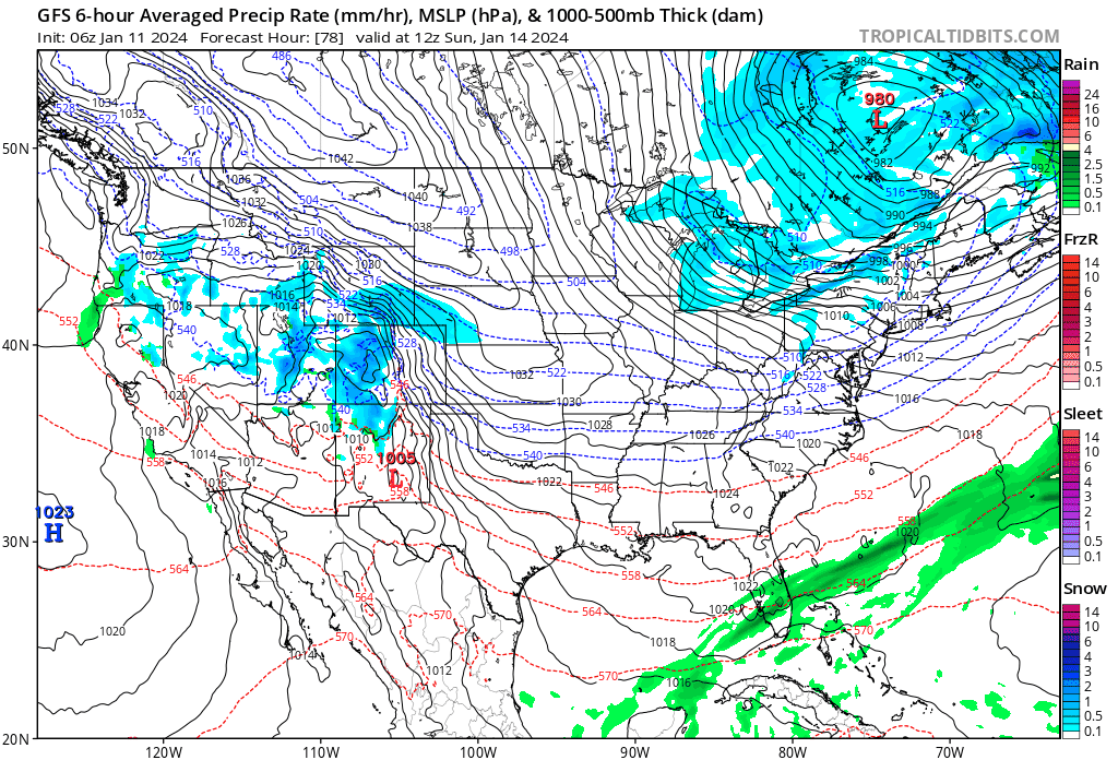
-
January 14-16 Major Winter Storm and Arctic Blast
Clinton replied to Black Hole's topic in East of the Rockies
CMC also snowy from I-70 on south -
January 14-16 Major Winter Storm and Arctic Blast
Clinton replied to Black Hole's topic in East of the Rockies
ICON and GFS coming in juicy tonight for Oklahoma, even giving some wintery precip to @Iceresistance and @Andie ICON GFS -
The morning of the last storm they showed me getting a dusting - 2 and I got 6. I don't like my odds with them showing accumulations for me lol.
-
EAX showing 2 -3 for me but my confidence is low on this one.
-
January 14-16 Major Winter Storm and Arctic Blast
Clinton replied to Black Hole's topic in East of the Rockies
EPS is looking good for you guys -
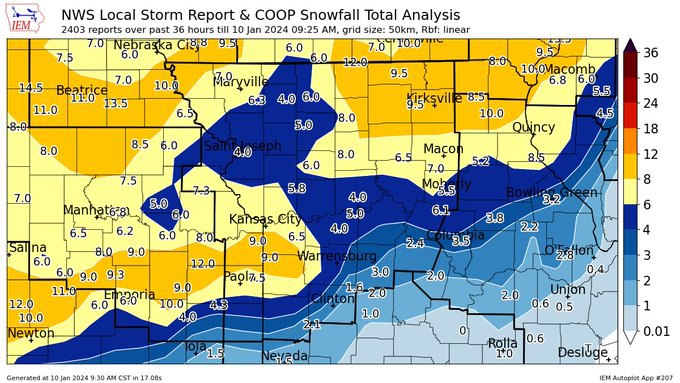
Final snowfall tallies from EAX
-
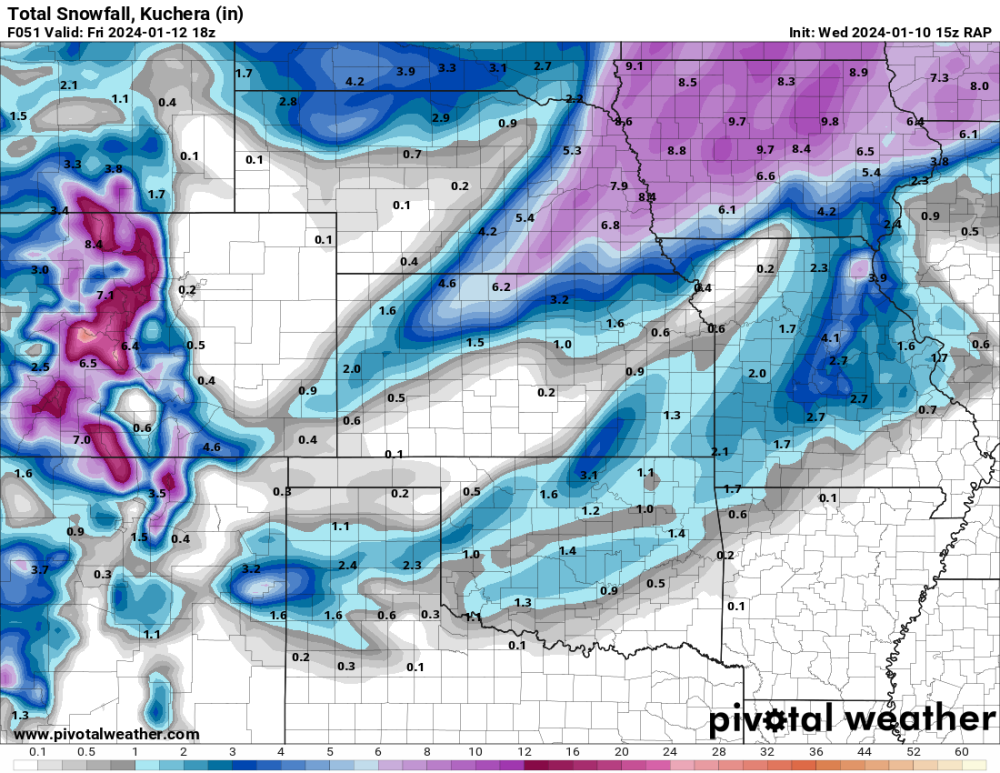
Supported also by the 15z RAP which does a little more with the deformation band in mby.
-
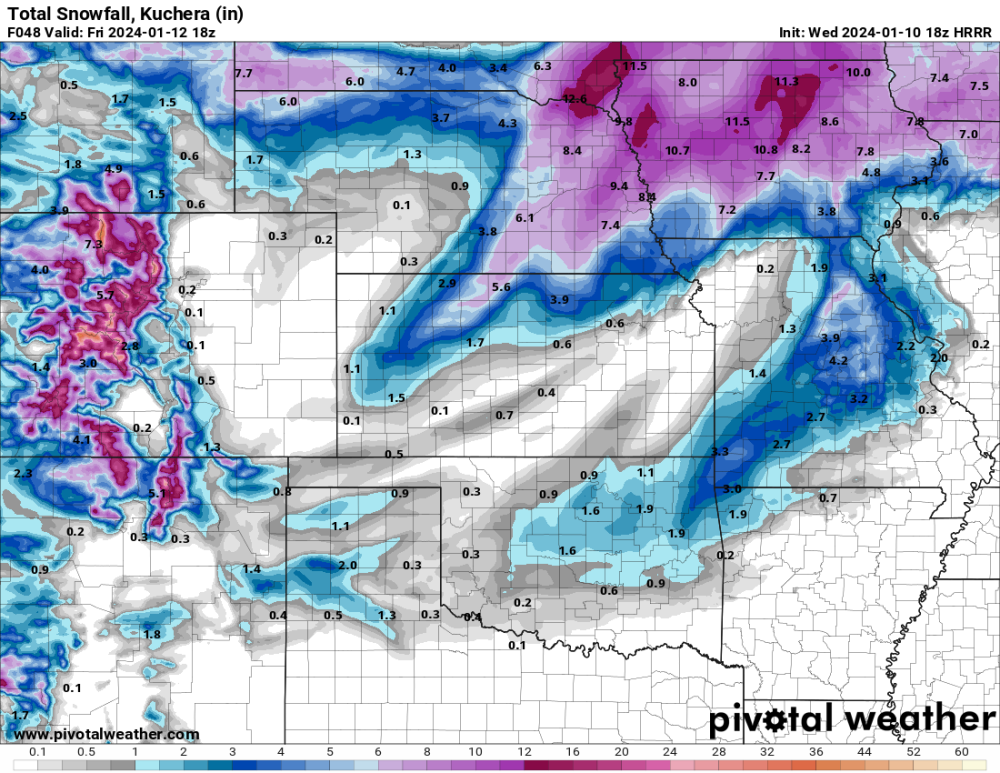
18z HRRR brings the deformation band just to my east. On this run @KTPmidMO and @ATW get a few inches and east Iowa gets some extra from it also.
-
January 2024 Observations and Discussion
Clinton replied to Minny_Weather's topic in East of the Rockies
Not poof but further south.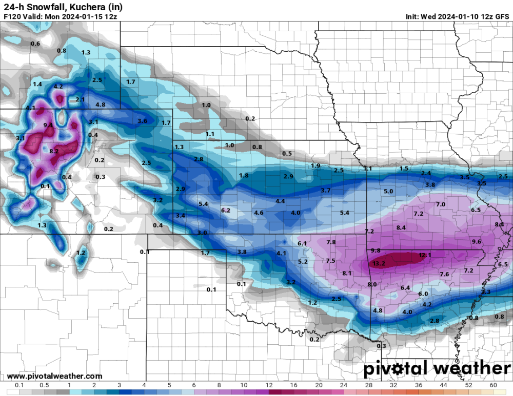
-
January 2024 Observations and Discussion
Clinton replied to Minny_Weather's topic in East of the Rockies
He very busy today. I can start a thread for that tonight unless you want to go ahead with it. -
January 2024 Observations and Discussion
Clinton replied to Minny_Weather's topic in East of the Rockies
Storm on Sunday getting my attention. No rest! -
RAP at hr 51
-
EAX this morning he next potential winter storm will begin to affect the area Thursday night. As a strong shortwave trough will dig into southern New Mexico/ southwestern Texas Thursday evening, widespread precipitation should develop in the baroclinic leaf region across western Nebraska and Kansas. That will spread eastward as the shortwave moves into the Plains. Strong forcing ahead of the shortwave will lead to widespread warm advection precipitation developing that quickly merges with the baroclinic precipitation as the surface low moves from southwest Oklahoma into southern Missouri. With surface temperatures expected to be near or above freezing in our southern/ southeastern zones Thursday evening, rain and/or rain/snow is expected in that area. The rest of the forecast area will be all snow given the entirely below freezing thermal profile. But with the low quickly moving east, temperatures cool in response and the entire forecast area will transition to snow by early Friday morning. This intense shortwave pivots to a negative tilt just south of the forecast area. That enhanced forcing could lead to a deformation band that potentially sets up across our south. Subtle variations in this track could greatly alter the forecast snow amounts. For now, the greatest amounts are across northern Missouri where a swath of 5+ inches looks possible. Then, with the potential deformation band, there`s a swath of 4+ inches in our southeastern zones that increases into northeastern Missouri. We considered a winter storm watch on this shift but decided to hold off given the uncertainty in the track and the lower end criteria snow amounts being forecast
-
That's a nice looking map to wake up to. Glad to see the GFS move NW a little.
-
Congrats! That's insane, make those $
-
0z CMC for the west half
-
Jumping your way though.
-
GFS clobbers me but barely.
-


