


Clinton
-
Posts
6559 -
Joined
-
Last visited
-
Days Won
28
Everything posted by Clinton
-

April 10th - 15th Extremely dynamic storm system
Clinton replied to Iceresistance's topic in East of the Rockies
Good call on the back to back cutters, I hope the drought areas can get some relief but models are already indicating moisture may stay east. -
April 10th - 15th Extremely dynamic storm system
Clinton replied to Iceresistance's topic in East of the Rockies
It always opens up a hornets nest anytime I bring up the LRC but here I go anyways. This storm fits the part of the pattern related to Dec 10th which produced a severe and deadly tornado outbreak for the Ohio Valley and is a big reason I favour the further south solutions with this storm. The following storm showing up after Easter will also be a big severe weather producer further NW. Current day 6 outlook. -
April 2022 Observations & Discussions
Clinton replied to Iceresistance's topic in East of the Rockies
Not a spring like day here this morning. I've had snow showers and windy cold conditions with a temp of 34. Freeze warning in effect for the entire area tonight with temp dipping into the middle 20s. -
April 10th - 15th Extremely dynamic storm system
Clinton replied to Iceresistance's topic in East of the Rockies
Hope I'm wrong but I lean towards the GFS on this upcoming storm, I'm much more optimistic about rain for Nebraska with the following storm on the 16th. -
April 2022 Observations & Discussions
Clinton replied to Iceresistance's topic in East of the Rockies
Winds were gusty yesterday and will be about the same today, only todays highs here will be in the mid 40s with clouds. -
April 10th - 15th Extremely dynamic storm system
Clinton replied to Iceresistance's topic in East of the Rockies
3 day severe weather event next week. If the gulf moisture can surge northward things could get real dicey! -
April 2022 Observations & Discussions
Clinton replied to Iceresistance's topic in East of the Rockies
It's going to be a windy Wednesday here with winds 25-35mph. The storm next week looks to be a fun one with severe weather, lots of rain and a blizzard up north. Should be a couple of days with large tornadoes possible in Oklahoma, big storm. -
April 2022 Observations & Discussions
Clinton replied to Iceresistance's topic in East of the Rockies
I could see some 80s early next week. That will be welcome after the cold Thursday and Friday. -
April 2022 Observations & Discussions
Clinton replied to Iceresistance's topic in East of the Rockies
Burrr! Cold opening week for baseball. -
April 2022 Observations & Discussions
Clinton replied to Iceresistance's topic in East of the Rockies
I picked up .25 inches of rain overnight and have thick fog this morning. The home opener for the Royals looks miserable with cloudy damp conditions and temps in the 40s. Looking forward to the second half of the month as temps should rise and the big thunderstorms hit. -
April 2022 Observations & Discussions
Clinton replied to Iceresistance's topic in East of the Rockies
A nice spring day is expected here with temps in the upper 60s. A quick line of rain moves through this evening.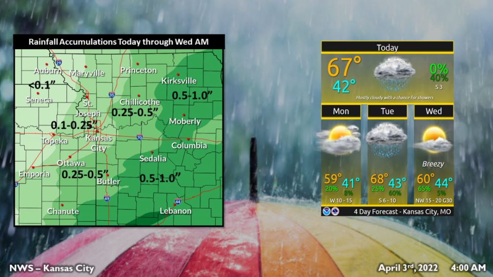
-
April 2022 Observations & Discussions
Clinton replied to Iceresistance's topic in East of the Rockies
Rain moves back in tonight. The storm early next week looks much wetter for my area. -
Hard freeze for my area tonight, lows will dip to the mid to upper 20s. I have one apricot tree that has started blooming already hope it can hang in there. Currently cloudy with a few flurries and a temp of 36.
-
Rain and sleet falling with a temp of 39. Cold way to finish off March.
-
KC area has been wet of late. NWS Kansas City @NWSKansasCity Yesterday, KC picked up 1.40"of rain falling just short of the daily record 1.44" (2017). The 1.40" KC received yesterday brings the monthly total to 5.13" over double the normal amount of 2.36". This is currently the 6th wettest March on the 134-year record
-
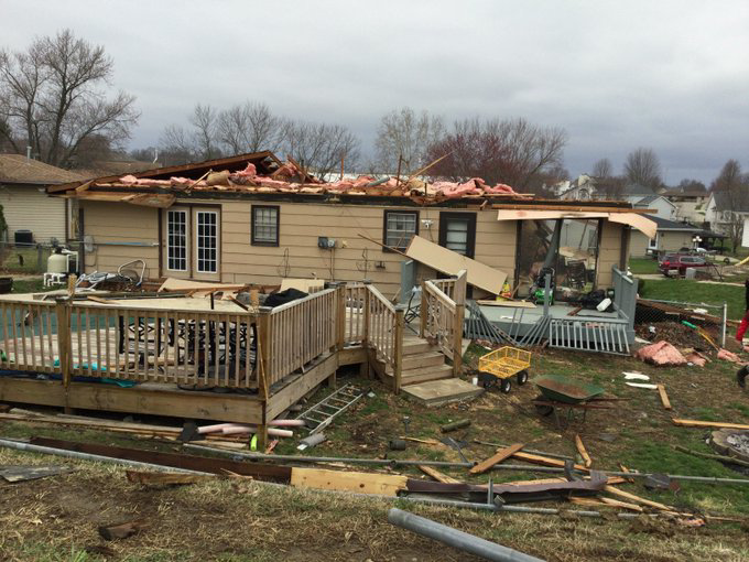
Confirmed EF1 tornado in the St Joe area last night.
-
My rainfall total was .90 and there's some snow showers in the forecast overnight and tomorrow morning.
-
2 counties on the Kansas side haven't had a tornado watch in over 2 years, that streak is still going.
-
Radar looks like this could turn into a flooding event for your area not much of a push east with that line.
-
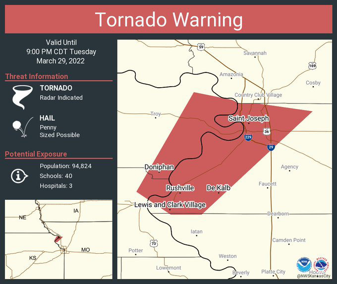
A pair of tornado warning north of KC. One looks to effect the St. Joe area.
-
12z GFS with a snowier solution on the NW side of the storm.
-
Strong straight line winds and hail look to be the primary threats for mby. Storms look to move in after dark and another good soaker looks to be on the way with 1-2 inches possible. The GFS has a sharp western edge more like a snow storm.
-
Today has been a rare average March day with temps in the 50s. Through the first 25 days of March, Kansas City is 1.2 degrees above normal but how we got here has been anything but normal. 19 of the 25 days has been at least 7 degrees above or below normal. And 13 have been over 12 degrees above or below normal
-
This storm will be a big severe weather producer across the south and the same areas that were hit last week. Impressive day 5 outlook
-
GFS is much further east with the precipitation compared with the Euro. Timing will be key but looks like the severe weather will split around mby. 0z GFS 0z Euro


