th_snow
-
Posts
34 -
Joined
-
Last visited
-
Days Won
1
Everything posted by th_snow
-
Some leaves are changing here up on the north shore of Lake Superior. Rain looking likely Monday night and Thursday. Love these fall like systems moving in
-
Winter 2016 Medium to Long Range Discussion; 5+ days out
th_snow replied to hlcater's topic in East of the Rockies
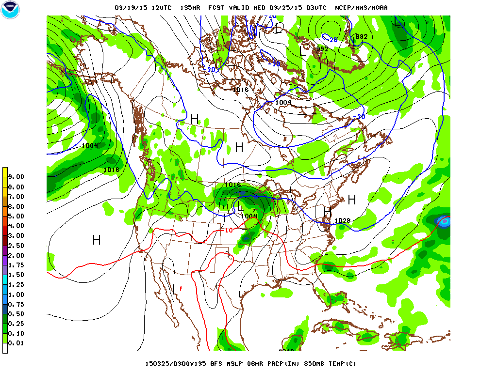
12Z GFS showing a potent little snow storm for northeast MN Tuesday , something to watch -
Winter 2016 Medium to Long Range Discussion; 5+ days out
th_snow replied to hlcater's topic in East of the Rockies
new ggem a lot different than the gfs midweek -
0z Ukie is well west of other guidance and the ggem shifted east from the 12z run.
-
euro is gonna be nw of the gfs
-
1.66" of rainfall today. Still raining.
-
Northern Plains/Great Lakes snow potential
th_snow replied to th_snow's topic in East of the Rockies
Models have definitely slowed this down and drawn in more cold air as the storm looks to have taken a more southern route. -
Northern Plains/Great Lakes snow potential
th_snow replied to th_snow's topic in East of the Rockies
Out of all the 0Z guidance that is in the ggem is the furthest south and strongest. Will be interesting to see if its right or not. Still a ways out until we know for sure. -
The models are hinting at a possible snow storm for the Dakotas, Minnesota, and Wisconsin for next Tuesday and Wednesday. Too early to know where the rain/snow line sets up as we have a few days to go to watch this. At least it will help some with the drought.
-
The Christmas storm might be legit. Every ensemble mean (GFS, ECMWF, CMC) show something going to the great lakes.
-
I wonder what the average snow cover for the U.S. for this time of year is.
-
Currently a few flurries falling with a temp of 43. Its been quite a few years since I have had flakes falling this late into May.
-
I better get used to it. 40s with a lake breeze will probably be the norm around here for the spring.
-
Made it up to 40 today. Had some sleet and light rain this morning. 0.12" of total precipitation.
-
34 here right now with some light snow this morning. No accumulation though even though 2 to 4" was predicted by the NWS.
-
Hit 57 for a high today. My warmest temp of the year so far. Snow depth down to 9". It was 28" one week ago today. Many roads in the area are closed due to the flooding caused by the snowmelt.
-
Agreed. its juiced.
-
RGEM looked pretty far west of the NAM for surface low position at 48 hours.
-
Quite the NAM run there. Most likely overdone though.
-
Agree, NAM is on a different planet.
-
0Z UKMET
-
Id toss the SREF. Looks odd.
-
Lots of model disagreement as the negative tilt trough kicks out of the Rockies. GFS has been ticking north on its latest model runs. ECMWF has been relatively consistent with a more northern track the past few runs. Will be interesting to see how this ends up verifying.
-
Still north of other guidance at 96 hours.
-
It very well could still. Theres just so much time for things to change I wouldnt lose hope for yourself.