ShawniganLake
-
Posts
15474 -
Joined
-
Last visited
-
Days Won
25
Everything posted by ShawniganLake
-

December 2014 Observations for the Pacific Northwest
ShawniganLake replied to stuffradio's topic in West of the Rockies
Keep calm and chive on. -
December 2014 Observations for the Pacific Northwest
ShawniganLake replied to stuffradio's topic in West of the Rockies
Well then I'm sold. Throw the old one in the trash. It's gonna cold and snow Christmas through New Years. -
December 2014 Observations for the Pacific Northwest
ShawniganLake replied to stuffradio's topic in West of the Rockies
Has this been an ongoing theme, or are we just jumping on its bandwagon because it's showing what we want to see. Weren't the other models playing catchup with the gfs last week with the windstorm. Seems sensible to be pretty cautiously optimistic at this point. -
December 2014 Observations for the Pacific Northwest
ShawniganLake replied to stuffradio's topic in West of the Rockies
Is there any/ enough data to show the new gfs had superiority over the older one. -
December 2014 Observations for the Pacific Northwest
ShawniganLake replied to stuffradio's topic in West of the Rockies
The Canadian this morning is a big improvement over the 0z for the 8-10 day period. Pumps the ridge up into Alaska. -
December 2014 Observations for the Pacific Northwest
ShawniganLake replied to stuffradio's topic in West of the Rockies
Euro ensemble looks encouraging. -8C 850 temps approaching the SW BC coast http://download.ecmwf.org/data/web249/get_legacy_plot-web249-20141216082753-28079-0767.gif -
December 2014 Observations for the Pacific Northwest
ShawniganLake replied to stuffradio's topic in West of the Rockies
http://www.mountwashington.ca/webcams/tubepark/full1.jpg Snowy night at mount Washington ski resort here on Vancouver Island. They need it. Click on the picture or link if you want to watch it snow in realtime. http://www.mountwashington.ca/winter/snow-tubing.html -
December 2014 Observations for the Pacific Northwest
ShawniganLake replied to stuffradio's topic in West of the Rockies
41/28 here today. -
December 2014 Observations for the Pacific Northwest
ShawniganLake replied to stuffradio's topic in West of the Rockies
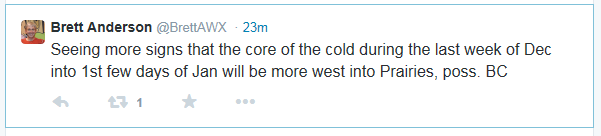
Latest tweet from Brett Anderson.
-
December 2014 Observations for the Pacific Northwest
ShawniganLake replied to stuffradio's topic in West of the Rockies
Mark posted the wrong maps. Take a second look. Not bad at all. Big time ridging through the Aleutians and western Alaska, Christmas through New years. -
December 2014 Observations for the Pacific Northwest
ShawniganLake replied to stuffradio's topic in West of the Rockies
The ridge axis is offshore. Looks chilly on Christmas morning to me. That isn't a torch. http://mp1.met.psu.edu/~fxg1/ECMWF0.5_12z/f240.gif -
December 2014 Observations for the Pacific Northwest
ShawniganLake replied to stuffradio's topic in West of the Rockies
I wouldn't call the long range GEM garbage. Pattern progression looks okay at days 8-10. Lacks amplification though. http://img.meteocentre.com/models/gemglb_amer_00/GZ_D5_PN_240_0000.gif -
December 2014 Observations for the Pacific Northwest
ShawniganLake replied to stuffradio's topic in West of the Rockies
A sporadic 60, maybe a 65, would seem like a reasonable expectation. -
December 2014 Observations for the Pacific Northwest
ShawniganLake replied to stuffradio's topic in West of the Rockies
Looks like you are reading it okay to me. The conservative approach is probably to way to go. -
December 2014 Observations for the Pacific Northwest
ShawniganLake replied to stuffradio's topic in West of the Rockies
Realism. Winds aren't going to gust to 75mph in Portland as the wrf and yourself have suggested. -
December 2014 Observations for the Pacific Northwest
ShawniganLake replied to stuffradio's topic in West of the Rockies
I think the chances for January have been good for some time, regardless of the warmth the past couple of days. When it comes to talking about payback, how do we know that the warmth this week isn't payback for the cold last week? Or the warmth this summer wasn't payback for the cold summers of a few years ago. It seems like an impossible thing to put a time stamp on. -
December 2014 Observations for the Pacific Northwest
ShawniganLake replied to stuffradio's topic in West of the Rockies
Of course he does. He is a pretty knowledgeable guy. Just a little guilty of wish casting from time to time, but he is an important part of the forum. -
December 2014 Observations for the Pacific Northwest
ShawniganLake replied to stuffradio's topic in West of the Rockies
I know. Just double checked, and actually the Jan 8-11 period has a nice arctic outbreak. That's a relief. Also, It is showing a 6 day blizzard for the second half of February. Its hour 1800, so its not a lock yet, but its something to watch. http://www.cascadeaccess.com/~mnelsen/Models/CFS_Model_2.html -
December 2014 Observations for the Pacific Northwest
ShawniganLake replied to stuffradio's topic in West of the Rockies
Pretty much all the cold goes east of the Rockies through mid January. Hasn't looked good for the last few days at least. Jim will be unhappy. -
Past news coverage of winter storms around Puget Sound
ShawniganLake replied to MossMan's topic in West of the Rockies
Southern Vancouver island https://www.youtube.com/watch?v=e7BloAdmqwo -
December 2014 Observations for the Pacific Northwest
ShawniganLake replied to stuffradio's topic in West of the Rockies
A link for anyone interested in this current storms impacts north of the border. http://www.cbc.ca/news/canada/british-columbia/b-c-flooding-risk-continues-as-3rd-storm-wallops-west-coast-1.2867042 -
December 2014 Observations for the Pacific Northwest
ShawniganLake replied to stuffradio's topic in West of the Rockies
Only 52F over here. We generally get much warmer with a SW wind, though. -
December 2014 Observations for the Pacific Northwest
ShawniganLake replied to stuffradio's topic in West of the Rockies
Not up here. 53F max high for the month. 19 lows of 32 or below and 17.5" of snow. Pretty decent month actually. Mean temp came in at 37.6F -
December 2014 Observations for the Pacific Northwest
ShawniganLake replied to stuffradio's topic in West of the Rockies
One heck of a rainstorm unfolding on central Vancouver Island. Looks to be unprecedented flooding in a few areas. From the BC river forecast centre: River levels on Vancouver Island and the Central Coast have risen substantially overnight and this morning. The Tsolum River near Courtenay (WSC 08HB011) is currently running at 278 m3/s (water level = 4.387 m), which is greater than the 100 year flow and has exceeded the maximum historical recorded flow (258 m3/s). The Oyster River below Woodhus Creek (08HD001) is currently running at 353 m3/s (water level = 2.982 m), which is greater than the 100 year flood and has exceeded the maximum historical recorded flow (260 m3/s). Environment Canada forecasts additional rainfall in the range from 30 mm to 50 mm for the region. Flows and water levels are expected to continue to rise tonight through tomorrow (December 10, 2014) at noon. -
December 2014 Observations for the Pacific Northwest
ShawniganLake replied to stuffradio's topic in West of the Rockies
We moved into our house in January. This summer we had three trees removed from our backyard that would be within striking distance. Good decision, as it turned out 2 of them had termites. Obviously there are situations that you cant control, however, depending on the size of your property. You cant always go cutting down every tree in the neighborhood.