mlgamer
-
Posts
802 -
Joined
-
Last visited
Everything posted by mlgamer
-
Pre-Christmas Storm Plains/MW/GL 12/21-12/22
mlgamer replied to bud2380's topic in East of the Rockies
12z GFS definitely a major step backwards for me. Rats. -
Looks like this is mainly a rainer here. Light rain and 37 degrees in MBY at 6:50 AM. Everything is wet.
-
Pre-Christmas Storm Plains/MW/GL 12/21-12/22
mlgamer replied to bud2380's topic in East of the Rockies
I'm wondering if it will set a record number of posts. Maybe break the thread? lol -
Pre-Christmas Storm Plains/MW/GL 12/21-12/22
mlgamer replied to bud2380's topic in East of the Rockies
Better yet, where am I getting the money to pay them? lol -
Pre-Christmas Storm Plains/MW/GL 12/21-12/22
mlgamer replied to bud2380's topic in East of the Rockies
This would be historic for MBY if the GFS even came close to verifying. Not sure what the drifting would look like with near 2 ft of snow. That said this seems overdone but the Nov 4 storm was a very wet storm and a favorable track for me (LRC). Amazing run nonetheless. -
Pre-Christmas Storm Plains/MW/GL 12/21-12/22
mlgamer replied to bud2380's topic in East of the Rockies
Same here. More like a cold front with a narrow window for advisory level snow is my gut feeling. Oddly enough, I wouldn't be surprised if I got more snow with Monday's small system. Keeping an open mind though... -
Yeah, wouldn't it be great if we could pull off a "snow on snow" with the Wed/Thu system...and right before Christmas to make it even better! lol
-
Could be, but this may turn into a big slopfest. May need that next system to tidy things up...lol.
-
Pre-Christmas Storm Plains/MW/GL 12/21-12/22
mlgamer replied to bud2380's topic in East of the Rockies
This is what got my attention... -
Pre-Christmas Storm Plains/MW/GL 12/21-12/22
mlgamer replied to bud2380's topic in East of the Rockies
Just reread that thread and forgot I had posted that. Even mentioned the storm coming back around Christmas. Should be interesting tracking the models in the coming days... -
Pre-Christmas Storm Plains/MW/GL 12/21-12/22
mlgamer replied to bud2380's topic in East of the Rockies
The storm track for the Nov 3-6 storm shows up nicely on these 24-hr precip maps for Nov 5 and Nov 6. This would be a great track for me and points northeast if the upcoming storm were to pan out in a similar fashion...and strength. 24-hrs 7:00 AM EST NOV 5th 24-hrs 7:00 AM EST NOV 6th -
December 2022 Observations and Discussion
mlgamer replied to Iceresistance's topic in East of the Rockies

- 1099 replies
-
- 10
-

-

-
December 2022 Observations and Discussion
mlgamer replied to Iceresistance's topic in East of the Rockies
Yeah, I hear ya, but it does show a snow hole over our region which makes it highly credible with me anyway...lol -
December 2022 Observations and Discussion
mlgamer replied to Iceresistance's topic in East of the Rockies
I think this is more of an issue with the tropical tidbit maps reflecting sleet and freezing precip rather than a GFS issue. The possibility of strong arctic high pressure suppressing the storm track and winter precip way south seems reasonable (and sadly typical for KS/MO...lol) -
December 2022 Observations and Discussion
mlgamer replied to Iceresistance's topic in East of the Rockies
The models have made it clear over the years that you could never issue watches this early in my neck of the woods. Even 24 hrs out is a crapshoot here. -
Sitting at 72 degrees but I'll be in the 40s by noon. As much as I like winter I'll miss the mild temps. Highs will be in the 30s and 40s here for at least the next week or more.
-
Election Day - Veteran's Day Major Winter Storm
mlgamer replied to Tom's topic in East of the Rockies

-
I didn't see any snowflakes but my storm total was 2.4" of welcome rain.
-
@KCSmokey just posted this as well, but the comma head is rotating nicely through the area this morning. This would have made for a nice major winter storm if cold air had been in place. I have not seen any snowflakes and have a current temp of 37.4F. Assuming a middle of the road LRC cycle of 50-55 days would bring this system back at Christmas or a few days after. White Christmas anyone? Of course the storm will likely look different in future cycles so maybe not as good...
-
Tom, I was about to create this very same GIF and post it. It's been a LONG time since I have seen a healthy closed low take this track. It actually reminds me of storms of the late 70s / early 80s. With cold air this would be a near perfect heavy snow track for me. The Canadian (and 06z GFS) has a similar storm and track. Even if it doesn't pan out, it was fun to see and be reminded of storms of yesteryear...lol
-
Looking at some of these model runs being posted reminded me that WISHCASTING SEASON is just around the corner!! (yeah, I know...I'll show myself out... )
-
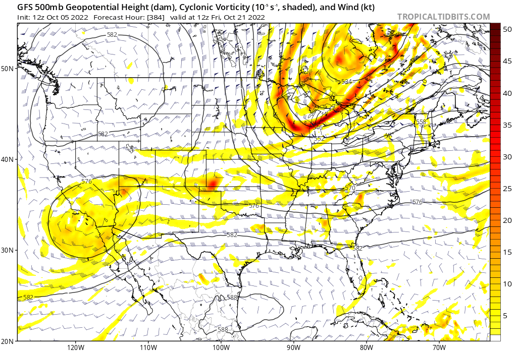
Interesting the 12z GFS has the "new LRC" energy Gary mentions becoming part of a western US Rex Block at the end of the run and also showing much of the country drying out at the same time (though some central plains areas receive welcome precip earlier in the run).

-
Weather History Continued...I went digging through the records and found: Topeka had 2.07" of rain on Sep 28-29, 1985 (and no snow which would be expected) Had a front loaded winter: Nov-Dec: 9.1" total snow and only 1.5" the rest of the 85-86 winter. No measurable precip at all in Jan 1986. Only traces of rain on Jan 18 and Jan 26.
-
Here in Topeka we had more rain in May than all of June-September combined. May: 11.68" June - September: 9.54"
-
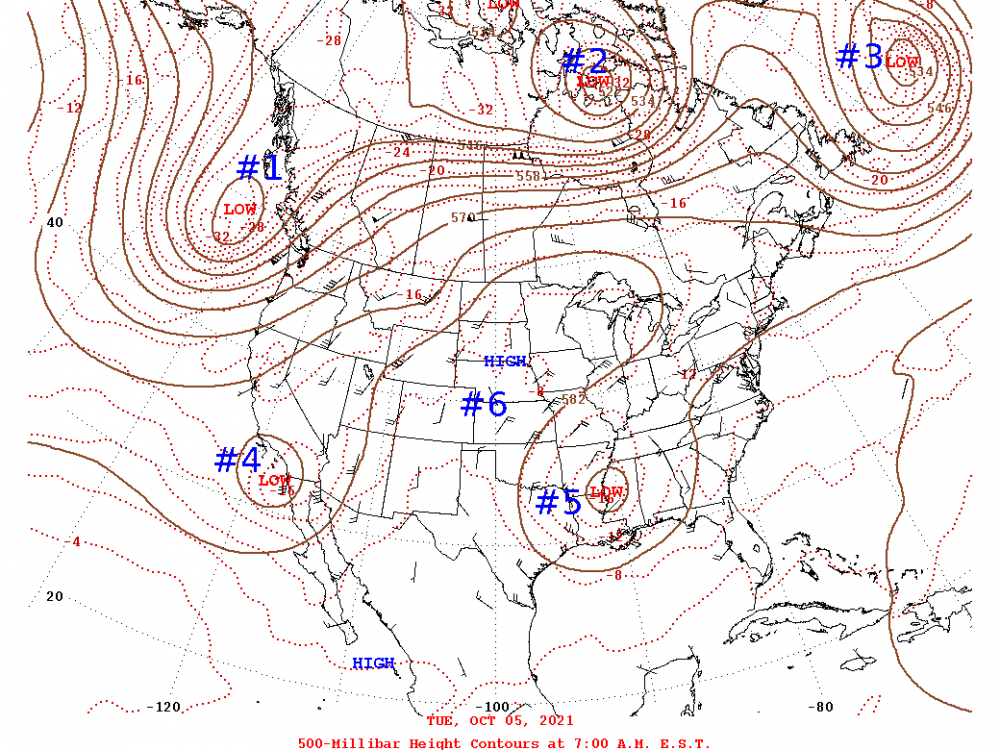
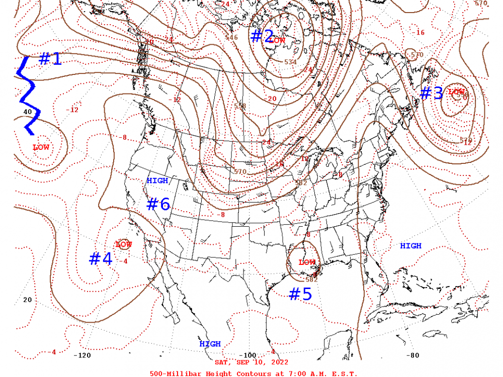
I know it might be a bit early but I was cruising the 500mb charts to see if there are any hints of a new LRC forming yet. These two maps are 340 days apart and dividing by 5 gives 68 days (a little higher than the 64/65 day current cycle length). In short, this quick and dirty still overall looks pretty much like the same pattern to me. (I know not everyone follows the LRC and I could be off in my thinking so this is for ENTERTAINMENT PURPOSES ONLY. )