


Frontal Snowsquall
-
Posts
7902 -
Joined
-
Last visited
-
Days Won
1
Everything posted by Frontal Snowsquall
-

December 2018 Weather in the Pacific Northwest
Frontal Snowsquall replied to Tyler Mode's topic in West of the Rockies
Let's save this for spring and summer. -
December 2018 Weather in the Pacific Northwest
Frontal Snowsquall replied to Tyler Mode's topic in West of the Rockies
One of the reasons why I love tracking hurricanes even though I live no where close to the SE. -
December 2018 Weather in the Pacific Northwest
Frontal Snowsquall replied to Tyler Mode's topic in West of the Rockies
The 12z EURO looks good at day 10. It might take a while for the ridge to build and amplify in our sweet spot but I think it'll eventually get there. I'm still thinking the 2nd week of January we can score. -
December 2018 Weather in the Pacific Northwest
Frontal Snowsquall replied to Tyler Mode's topic in West of the Rockies
Yeah, back then I was just new into weather and I got too hyped up. That event humbled me. -
December 2018 Weather in the Pacific Northwest
Frontal Snowsquall replied to Tyler Mode's topic in West of the Rockies
A little sad and angry but mainly embarrassed. The biggest bust I ever experienced was January 2011. When models were showing 1 to 2 feet of snow for PDX, I felt so confident about it that I was telling all my family, friends and collegemates a big snowstorm was going to happen. I figured even if the models backed off a bit we would still get a good snowstorm. Well we got barely anything as the system kept trending north right up to the last minute. It was the worst feeling ever. -
December 2018 Weather in the Pacific Northwest
Frontal Snowsquall replied to Tyler Mode's topic in West of the Rockies
Right around the same intensity as the Manzanita Tornado down here in 2016. -
December 2018 Weather in the Pacific Northwest
Frontal Snowsquall replied to Tyler Mode's topic in West of the Rockies
The EURO is colder with the backdoor blast compared to the GFS and GEM. Yeah, great potential ahead! -
December 2018 Weather in the Pacific Northwest
Frontal Snowsquall replied to Tyler Mode's topic in West of the Rockies
I see. You're more of the severe expert so I'll take your word for it. -
December 2018 Weather in the Pacific Northwest
Frontal Snowsquall replied to Tyler Mode's topic in West of the Rockies
Judging by how that tree just snapped, I gotta believe that's an EF3 Tornado right there. -
I'd say it's pretty close between the two. From a rain and wind perspective it's pretty much even. Puget Sound gets more snow on average but the Willamette Valley gets better ice storms. Eugene just had a big one 2 years ago that caused lots of damage and East PDX Metro is always prone to ice storms due to the Gorge outflow. If we include heatwaves to the equation, then I'd give the slight lean towards the Willamette Valley since we get warmer temperatures during the summer. The one thing that the Puget Sound has over the Willamette Valley is their convergence zone. I wish we had something like that down here.
-
December 2018 Weather in the Pacific Northwest
Frontal Snowsquall replied to Tyler Mode's topic in West of the Rockies
Wow, that's way too close for comfort. Glad they are all safe. -
December 2018 Weather in the Pacific Northwest
Frontal Snowsquall replied to Tyler Mode's topic in West of the Rockies
No kayaks were needed today. Only got up to 5.25 feet this morning. Well below the 11.8 feet that was being forecasted. https://water.weather.gov/ahps2/hydrograph.php?gage=syco3&wfo=pqr -
December 2018 Weather in the Pacific Northwest
Frontal Snowsquall replied to Tyler Mode's topic in West of the Rockies
Yeah, some nice backdoor action inside 10 days. -
December 2018 Weather in the Pacific Northwest
Frontal Snowsquall replied to Tyler Mode's topic in West of the Rockies
Knock it off. You're taking my post too seriously. When I saw the video it looked really scary and I imagined what it would feel like being there. Hopefully nobody got hurt. -
December 2018 Weather in the Pacific Northwest
Frontal Snowsquall replied to Tyler Mode's topic in West of the Rockies
Thanks for sharing. That just got my blood pumping. -
December 2018 Weather in the Pacific Northwest
Frontal Snowsquall replied to Tyler Mode's topic in West of the Rockies
That's wild! Has to have been an F3 to tear those houses apart. -
December 2018 Weather in the Pacific Northwest
Frontal Snowsquall replied to Tyler Mode's topic in West of the Rockies
Yeah, the biggest takeaway I took from it was it increases pretty much everyone's chances of getting colder weather in the CONUS. We're going to need the strong North Pacific Jet to shut down for a while. -
December 2018 Weather in the Pacific Northwest
Frontal Snowsquall replied to Tyler Mode's topic in West of the Rockies
Some good information about the possible impacts of the upcoming SSW event. It looks like almost all of the CONUS is colder than normal the next 60 days after a historic SSW event. Also looks like the PNW is wetter than normal. Amy H Butler @DrAHButler What are possible impacts of #SSW? From our SSW compendium (https://www.esrl.noaa.gov/csd/groups/csd8/sswcompendium/), this plot shows the anomalous mean sea level press, temp, and precip averaged for 60 days after every historic SSW event. https://twitter.com/DrAHButler/status/1075064716316344320 -
December 2018 Weather in the Pacific Northwest
Frontal Snowsquall replied to Tyler Mode's topic in West of the Rockies
Yeah, last winter the SSW event just barely came in time for the cold air to produce something. We got an extra 1.5 months of scoring this time around. -
December 2018 Weather in the Pacific Northwest
Frontal Snowsquall replied to Tyler Mode's topic in West of the Rockies
They are always hungry. -
December 2018 Weather in the Pacific Northwest
Frontal Snowsquall replied to Tyler Mode's topic in West of the Rockies
It's going to be exciting watching this all unfold. -
December 2018 Weather in the Pacific Northwest
Frontal Snowsquall replied to Tyler Mode's topic in West of the Rockies
So they've more than doubled their average rainfall for the month and could be close to tripling it. That's pretty impressive. -
December 2018 Weather in the Pacific Northwest
Frontal Snowsquall replied to Tyler Mode's topic in West of the Rockies


-
December 2018 Weather in the Pacific Northwest
Frontal Snowsquall replied to Tyler Mode's topic in West of the Rockies

-
December 2018 Weather in the Pacific Northwest
Frontal Snowsquall replied to Tyler Mode's topic in West of the Rockies
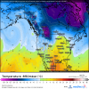
The 00z EURO EPS Control run just came in and it looks good in the long range. The 850mb temps get down to around -14C to -16C just east of the OR/WA Cascades on the 29th. I'll try to post maps in a bit unless somebody already gets to it.


