Frontal Snowsquall
-
Posts
7861 -
Joined
-
Last visited
-
Days Won
1
Everything posted by Frontal Snowsquall
-

September 2018 Weather in the Pacific Northwest
Frontal Snowsquall replied to TigerWoodsLibido's topic in West of the Rockies
The 00z GEM and GFS both look cool for the foreseeable future. They both show a nice trough dig in a little over a week from now. -
September 2018 Weather in the Pacific Northwest
Frontal Snowsquall replied to TigerWoodsLibido's topic in West of the Rockies
How many inches did you get from the late February event? -
Summer forecast contest, year three.
Frontal Snowsquall replied to Phil's topic in West of the Rockies
Mr. Marine Layer, thanks for calculating the results and showing how well we all did for each location! Based on my results, my most accurate location was PDX and my least accurate was DCA. Which makes sense because I live in PDX and I'm not really familiar with DCA and the East Coast. -
September 2018 Weather in the Pacific Northwest
Frontal Snowsquall replied to TigerWoodsLibido's topic in West of the Rockies
Looks like Florence has found a home and is just spinning ever so slowly inside Onslow Bay. Just as you said last night, these areas are no strangers to hurrricanes. -
September 2018 Weather in the Pacific Northwest
Frontal Snowsquall replied to TigerWoodsLibido's topic in West of the Rockies
Here's a good radar loop to track hurricane Florence. It updates every 2 minutes, you just have to hit refresh. http://wx.graphics/models/MRMS_radar_northcarolina.gif -
September 2018 Weather in the Pacific Northwest
Frontal Snowsquall replied to TigerWoodsLibido's topic in West of the Rockies
Florence has strengthened 5 mph. Looks like it's starting to intensify. Michael Ventrice@MJVentrice I am fearing that this might be the early stage of a rapid intensification process of #HurricaneFlorence. Another burst of convection to the north of the eye of the hurricane in recent frames. We'll see if this cyclonically wrapping eyewall completes its orbit around the eye. https://mobile.twitter.com/MJVentrice/status/1040357079826014208 -
September 2018 Weather in the Pacific Northwest
Frontal Snowsquall replied to TigerWoodsLibido's topic in West of the Rockies
The 12z EURO ensemble mean has Florence making landfall at Cape Fear then it wobbles slightly offshore before final landfall around Charleston. It heads up into the Appalachians before heading out to sea but that might not be the end of it. Chance it might loop back towards the East Coast again. That's still way out there though. http://oi67.tinypic.com/2cwrex0.jpg -
September 2018 Weather in the Pacific Northwest
Frontal Snowsquall replied to TigerWoodsLibido's topic in West of the Rockies
Florence could re-intensify back into a major hurricane before landfall. Ryan Maue@RyanMaue Another thing to note is that the ECMWF has a good initialization of #Florence and intensifies it in the next 12-18 hours. The 850 hPa winds of 125-knots are more indicative of a major hurricane. https://mobile.twitter.com/RyanMaue/status/1040309477738782722 -
September 2018 Weather in the Pacific Northwest
Frontal Snowsquall replied to TigerWoodsLibido's topic in West of the Rockies
The 12z EURO shows Florence clipping Cape Fear then heads down the SC coastline before making landfall around Georgetown. EURO still persistent with more off an offshore track with Florence. http://wx.graphics/models/ecmwf_florence.png -
September 2018 Weather in the Pacific Northwest
Frontal Snowsquall replied to TigerWoodsLibido's topic in West of the Rockies
Looks like it's about to make it's turn for Wilmington. The storm surge/flooding is going to be incredible with this one due to how huge she is and how slow she's coming in. Levi Cowan@TropicalTidbits Recon fixes (orange dots) of #Florence's position indicate what may be the start of the expected left turn toward the Wilmington area. The storm is in the process of slowing down, as expected. Landfall may not occur until tomorrow afternoon. There is a very long ride ahead. http://i66.tinypic.com/52e742.jpg -
September 2018 Weather in the Pacific Northwest
Frontal Snowsquall replied to TigerWoodsLibido's topic in West of the Rockies
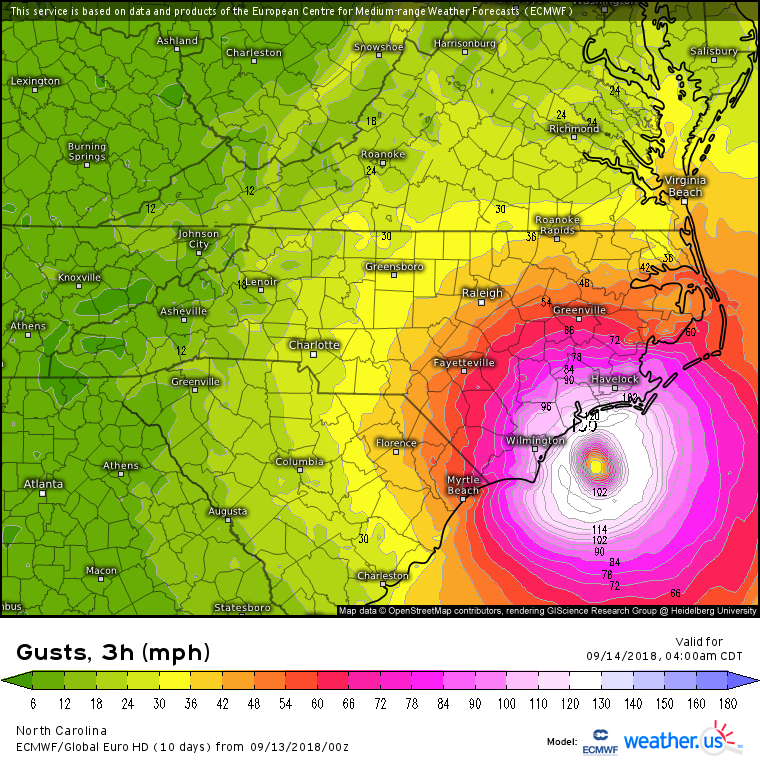
Yeah, it still shows wind gusts over 100 mph as it moves down the SC coastline. Also still dumps a ton of rain.
-
September 2018 Weather in the Pacific Northwest
Frontal Snowsquall replied to TigerWoodsLibido's topic in West of the Rockies
The 00z EURO makes landfall at Wilmington but then still wants to ride down the Carolina coastline. http://wx.graphics/models/ecmwf_florence.png -
September 2018 Weather in the Pacific Northwest
Frontal Snowsquall replied to TigerWoodsLibido's topic in West of the Rockies
-
September 2018 Weather in the Pacific Northwest
Frontal Snowsquall replied to TigerWoodsLibido's topic in West of the Rockies
-
September 2018 Weather in the Pacific Northwest
Frontal Snowsquall replied to TigerWoodsLibido's topic in West of the Rockies
Same here. If I saw this thing coming, I would have been long gone by now. -
September 2018 Weather in the Pacific Northwest
Frontal Snowsquall replied to TigerWoodsLibido's topic in West of the Rockies
Yeah, also dumps a ton of rain on the coast.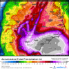
-
September 2018 Weather in the Pacific Northwest
Frontal Snowsquall replied to TigerWoodsLibido's topic in West of the Rockies
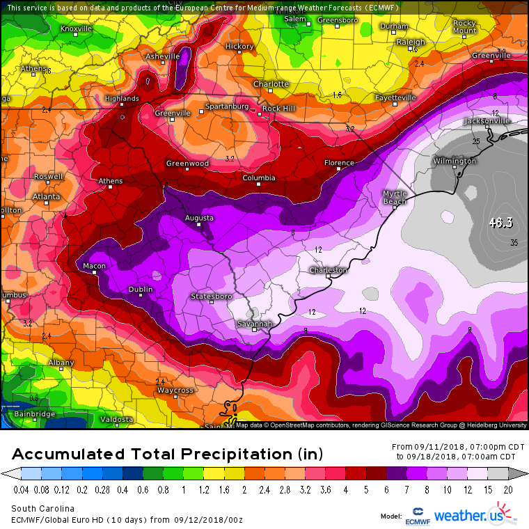
Then it heads inland around Charleston. -
September 2018 Weather in the Pacific Northwest
Frontal Snowsquall replied to TigerWoodsLibido's topic in West of the Rockies
Looks like the 12z EURO has Florence scraping Cape Fear before the slow jog down the Carolina coastline. http://wx.graphics/models/ecmwf_florence.png -
September 2018 Weather in the Pacific Northwest
Frontal Snowsquall replied to TigerWoodsLibido's topic in West of the Rockies
-
September 2018 Weather in the Pacific Northwest
Frontal Snowsquall replied to TigerWoodsLibido's topic in West of the Rockies
-
September 2018 Weather in the Pacific Northwest
Frontal Snowsquall replied to TigerWoodsLibido's topic in West of the Rockies
What a crazy day of model riding. It's been a roller-coaster ride today. I'm nauseous now, time to get some rest. See you all tomorrow for more fun. -
September 2018 Weather in the Pacific Northwest
Frontal Snowsquall replied to TigerWoodsLibido's topic in West of the Rockies
Yeah, it still looks like though it dumps a lot of rain along the South Carolina coast.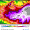
-
September 2018 Weather in the Pacific Northwest
Frontal Snowsquall replied to TigerWoodsLibido's topic in West of the Rockies
Yeah, if this verifies, landfall as a major hurricane in NC. Then probably still a hurricane in GA. That would be crazy. -
September 2018 Weather in the Pacific Northwest
Frontal Snowsquall replied to TigerWoodsLibido's topic in West of the Rockies
Yeah, here's the track Florence takes on the 00z EURO. http://wx.graphics/models/ecmwf_florence.png -
September 2018 Weather in the Pacific Northwest
Frontal Snowsquall replied to TigerWoodsLibido's topic in West of the Rockies
The 00z EURO adds another twist to the forecast. Looks like it makes landfall just at the tip of Cape Fear, stalls some then heads just enough offshore to maintain strength then eventually jogs SW and makes landfall in Savannah GA.