


jaster220
-
Posts
12212 -
Joined
-
Last visited
-
Days Won
59
Everything posted by jaster220
-
 Yep, extremely close call there in the GR region:
-
Yesterday, we torched about 8 or 10 degrees higher than the forecast from earlier this week (DTW hit 54F vs 44F for instance). Guess they forgot it is still just November despite having looked and felt more like January for about 4 days. In the big Nino of 2015-16, I was fortunate to get 2 storm warned events, but it torched up to the mid-40s during the 3 days in between. I remember thinking that 2nd storm would be DOA due to warmth, but the CF raced south out of Canada with perfect timing to save the storm similar to today's event. Ofc, this is the front end shoulder season right now, so you're fighting climo to get a similar outcome.
-
Yeah, He is good and earned a respect no doubt. 38.5" would be my best winter in 5 yrs! (SMH)
-
Hopefully a good sign for yby deeper into winter when we have cold air to work with. Doesn't always work out that way unfortunately but CAW is a special combo when it does happen.
-
DECEMBER 2023 Observations and Discussion
jaster220 replied to Grizzcoat's topic in East of the Rockies
Would be nice to view the NL's -
DECEMBER 2023 Observations and Discussion
jaster220 replied to Grizzcoat's topic in East of the Rockies
Same 12z Euro puts together a pretty intense little storm for NY and N New England/Maine late weekend into Monday. Winter isn't totally "gone" from the CONUS. -
Nothing too scientific here, but it was the end of a multi-decadal cold period and as they say, it's always darkest before the dawn. Tbh, it may have been something a lot like what seems to be developing this year. This early winter is showing signs that it has the ingredients for big storms. Just need to get deeper into winter for our side to have a chance. Found this to be another hint: And how crazy would it be if this forecast actually came true??

-
DTX And again, where have I seen this b4?? GFS trying to show that RN/SN line:
-
11/25 - 11/27 CO/LOW Central Plains Snow and LES
jaster220 replied to Clinton's topic in East of the Rockies
It was a perfect arctic blast over those warmer waters for sure. This storm was last Christmas "lite". RIght around 17" seems to be the most in the LP of Michigan. Preliminary Local Storm Report National Weather Service Gaylord MI 234 PM EST Tue Nov 28 2023 ..TIME... ...EVENT... ...CITY LOCATION... ...LAT.LON... ..DATE... ....MAG.... ..COUNTY LOCATION..ST.. ...SOURCE.... ..REMARKS.. 0234 PM Snow 1 NW Waters 44.91N 84.72W 11/28/2023 M17.0 inch Otsego MI Official NWS Obs NWS Gaylord office. Storm total since early Sunday morning. -
Sux to say but I think you're a year tardy to the Minny Party
-
November 2023 Observations and Discussion
jaster220 replied to westMJim's topic in East of the Rockies
Day 4 of winter here with DTW at 28F. I think this LRC has some legs for sure, and will be remembered as the anti-Nino of 23-24 -
November 2023 Observations and Discussion
jaster220 replied to westMJim's topic in East of the Rockies
That 2011 rainstorm listed as historic for SEMI had an historic snowy side as well (imho). The SE region of GRR's CWA received 8-10" of heavy wet "concrete snow" that fell at 2"/hr with the classic massive flakes. The 8.1" recorded at the official Lansing site is the 7th largest November snowfall on the books (records back to 1863 btw). This snow zone extended SSW down to Battle Creek/Marshall area as well. BC data is all "missing" for that date, but I recorded 8.5" that fell in about 4 hrs. I was having fun stuck in traffic on I-94 during my evening commute and ended up exiting and taking some back roads home into Marshall. This was my 4th largest personal Nov snowstorm total. #1) 11-05-90=16.0" #2) 11-21-15=12.5" #3) 11-16-89=10.0" #4) 11-29-11=8.5" #5) 11-25/6-75=6.1" -
November 2023 Observations and Discussion
jaster220 replied to westMJim's topic in East of the Rockies
Welcome back to The Mitt amigo. Cool, thx for posting this. Too bad I missed the chance to see the headline myself. I swear that DTW has some kind of LES magnet going. They're always getting hit at least since my move here. -
11/25 - 11/27 CO/LOW Central Plains Snow and LES
jaster220 replied to Clinton's topic in East of the Rockies
Reports are scant this moring tbh, but it looks like Mancelona, one of the triangle of white gold anchor points, showing the best report of just under 14" over the past 2 days (with more on tap today).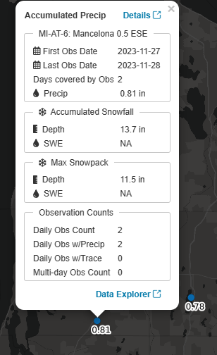
-
11/25 - 11/27 CO/LOW Central Plains Snow and LES
jaster220 replied to Clinton's topic in East of the Rockies
Did they issue a Squall Warning? If they did, I missed it unfortunately. The one N of here last winter died as it came south into the lower elevation and UHI (as usual). I'd like to see a legit one myself as long as I am not caught in it on the highways. A couple blobs of LES turned US23 into a skating rink yesterday morning up near Fenton/Grand Blanc. Accidents and slide-offs were snarling traffic crawling along at 20 mph. Being stuck in that is one of my least favorite things about winter car travel. -
11/25 - 11/27 CO/LOW Central Plains Snow and LES
jaster220 replied to Clinton's topic in East of the Rockies
Looks like I ended up on the northern edge of the streamer with about 0.5" here, while DTW put up a report of 1.7" from a snow squall that apparently hit hardest around 10 pm. With that amount my 2-day total takes me slightly AN for the month of November and that makes 2 straight months as my 2 tenths on Halloween was AN as well. The avg here for October is 0.0" -
11/25 - 11/27 CO/LOW Central Plains Snow and LES
jaster220 replied to Clinton's topic in East of the Rockies
Thx @Tom Actually, it was more the center of the Northland and I happened to pass very close to the APX office in Waters, MI where winter was in full swing. 21F with on/off +SHSN (not quite squall level). WC's with the snow were bitter and iced my entire windshield over during the 20 mins I was taking a lunch break at Panera. Plenty of snow blowers getting a workout with 5 to 6" down by early pm. I missed my AWD 300C. It was a day when it would've been worth the extra $$ that ride cost, lol. -
November 2023 Observations and Discussion
jaster220 replied to westMJim's topic in East of the Rockies
1995, The November to remember! Leading into my snowiest winter Kalkaska had over 64" -
11/25 - 11/27 CO/LOW Central Plains Snow and LES
jaster220 replied to Clinton's topic in East of the Rockies
I see this map was thru Tues 7 am. So far, part 1 has performed better than expected here. Let's see how part 2 LES plays out and whether I can end up scoring the 2+ shown on this map. Will all come down to getting lucky with a streamer like last November. -
11/25 - 11/27 CO/LOW Central Plains Snow and LES
jaster220 replied to Clinton's topic in East of the Rockies
Went out to get take-out dinner. Snow gently falling, snow OTG, right a 32F with the roads just a bit slushy. All the holiday lights were on and sparkling magic with snow on the trees. I think it's one of the snowiest Thanksgiving holidays I've personally had. We lucked out here with that clipper 2 years ago. Besides tonight, that's the only other snowy one of the last decade. -
11/25 - 11/27 CO/LOW Central Plains Snow and LES
jaster220 replied to Clinton's topic in East of the Rockies
Must be holiday hang-over or something. Only (1) report in for The Mitt so far, and it's from U of M. I'd say very similar results here so far if I had an elevated snow board.
-
11/25 - 11/27 CO/LOW Central Plains Snow and LES
jaster220 replied to Clinton's topic in East of the Rockies
This looks like fun. Snagging 18" overnight would mean a "Snow Day" for me, lol. Yoopers prolly just commute via snow or dog sleds instead.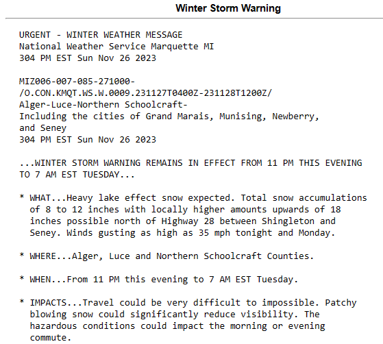
-
11/25 - 11/27 CO/LOW Central Plains Snow and LES
jaster220 replied to Clinton's topic in East of the Rockies
I can see why you really like synoptic events (sarc) -
Exactly what I just watched in the WxBell vid. Bastardi saying Christmas week should be interesting. His core analog set (DEC) 57/65/02/09 looks like a freaking overlay of the Euro for next month. Globally as well, not just N America.
-
Have seen 14-15 listed as a weak Nino. This week, his video really showing a strong correlation between WxBell's core analog winters and where the Euro is going with December. WeatherBELL Analytics (scroll to bottom of pg)


