

jaster220
-
Posts
12213 -
Joined
-
Last visited
-
Days Won
59
Everything posted by jaster220
-

11/25 - 11/27 CO/LOW Central Plains Snow and LES
jaster220 replied to Clinton's topic in East of the Rockies
Looks like WWA's just N of yby?? Edit- a few counties north -
@Tom Just watched last week's Saturday Summary and JB had a great segment on how the JMA is showing a very strong resemblance to 2014-15 as you go month-to-month. That ofc would mean we may roast and get very bored with December.
-
11/25 - 11/27 CO/LOW Central Plains Snow and LES
jaster220 replied to Clinton's topic in East of the Rockies
Are you in Clinton? @Clinton -
11/25 - 11/27 CO/LOW Central Plains Snow and LES
jaster220 replied to Clinton's topic in East of the Rockies
I have business up north Monday morning. Looking a bit wintry per APX -
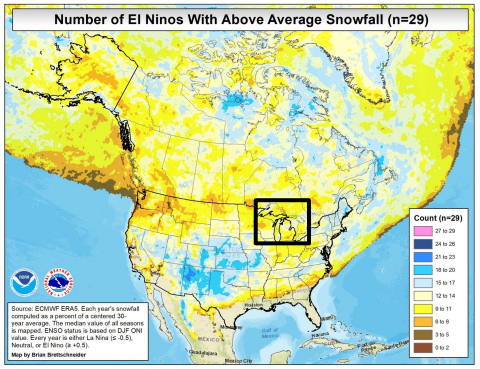
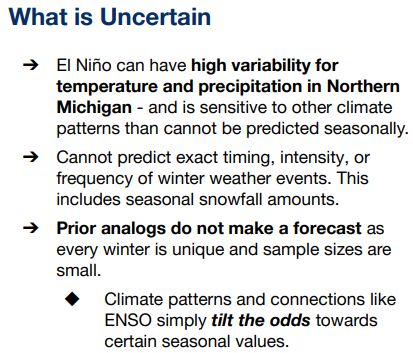
Another interesting map from that forecast. This shows how the stronger Ninos really increase the odds for AN snowfall in the S Plains region. There is also a small signal across the northern portion of mid-Michigan area that is slightly AN odds for good snowfall. I will give them kudos for a nice list of "CYA" caveats:
-
From APX's winter forecast (ofc they're just running with the "strong Nino incoming" mantra). I found this interesting: Figuring those AN temps just HAD to be bad news for your winter outcome, right?? Wrong. Gaylord with "only" 162 inches on the season: The gradient between Grayling and Gaylord is a mere 6 FEET of snow on the season. Krazy
-
November 2023 Observations and Discussion
jaster220 replied to westMJim's topic in East of the Rockies
Was 24F this morning and a balmy 34F when I went out about 1 pm. I already did the winter sealing where needed so it has been quite cozy and the furnace has barely run. I remember it running once or twice overnight. -
11/25 - 11/27 CO/LOW Central Plains Snow and LES
jaster220 replied to Clinton's topic in East of the Rockies
Holiday weekend mood flakes ftw -
11/25 - 11/27 CO/LOW Central Plains Snow and LES
jaster220 replied to Clinton's topic in East of the Rockies
At least we are tracking the chance, and it is still just November. Despite full-on sunshine and near cloudless skies, it stuck out at the supermarket parking lot where I saw a puddle was still half ice. First icing of any type that I have seen here in the metro. -
11/25 - 11/27 CO/LOW Central Plains Snow and LES
jaster220 replied to Clinton's topic in East of the Rockies
LOL, yep the 12z NAM got the messaging puts that line right where DTX said. Gonna ride the line EDIT- 3km resolution actually looks better, though at h57 this is quite far away for confidence but it does reinforce the notion that the line will be close by here.


-
11/25 - 11/27 CO/LOW Central Plains Snow and LES
jaster220 replied to Clinton's topic in East of the Rockies
DTX: For mby, it would read: "2 to 3 degrees is going to be the difference between a slushy inch or 2 vs NADA" Per their AFD, this is where they see the "mixing issues" line. I am just NW of it and would presume UHI will win the wrestling match especially being shoulder season. To note, that same line back in the 3/3 snowstorm divided those that got full warning amounts (8" here) and those that were more in the advisory level 4-6" amounts such as DTW, just 9 miles SSE of here. -
11/25 - 11/27 CO/LOW Central Plains Snow and LES
jaster220 replied to Clinton's topic in East of the Rockies
Same here. While the models have been consistent in showing about 1-1.5" here, my grid cast looks like a sloppy mix with highs in the upper 30s. Prolly a weak grass-topper at best here in the UHI zone. Get 5 miles west and I suspect there will be snow OTG. Thanksgiving weekend being earlier this year is already a strike against our odds, since the avg including the very late years (30th say) is only a paltry 0.2" so we are still in mood flake season tbh. -
11/19 - 11/22 Arklatex Low - Great Lakes/OHV Cutter???
jaster220 replied to Tom's topic in East of the Rockies
I'm dreaming of a solid 1" qpf event (non-summer convection). Over here it seems hard to achieve. Gone many months with smaller events. What was fairly common place in Marshall seems to be a challenge here. I think maybe we had one last Nov or Dec. Will have to look. Edit- Sort of correct. No 1"+ events this autumn yet, but last winter (more wet than white here) we were able to score about one event per month. This autumn has been noticeably drier and the deficit is growing at -2.63" for SON. -
11/25 - 11/27 CO/LOW Central Plains Snow and LES
jaster220 replied to Clinton's topic in East of the Rockies

-
Next d10+ tease storm from the GFS:
-
November 2023 Observations and Discussion
jaster220 replied to westMJim's topic in East of the Rockies
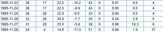
As you say, rare. Based on 22 yrs I don't think you remember the one that sticks in my memory which was Nov/Dec '95. There were at least 2 storms in November and it just kept going into and through December. Whitest Christmas of my life. Houghton Lake had 4" OTG on the 23rd for Thanksgiving, and then was ground-zero for the storm a few days later.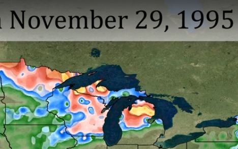
-
11/25 - 11/27 CO/LOW Central Plains Snow and LES
jaster220 replied to Clinton's topic in East of the Rockies
DTX -
November 2023 Observations and Discussion
jaster220 replied to westMJim's topic in East of the Rockies
Gotta believe its just a matter of time until something like that comes down in Feb 2015 fashion. There was 0F temps just north of Superior that caused the 11-16-89 bliz. Your map is later in the month and even colder so probably on the same order of magnitude. I don't track Canadien temps but would imagine it is not too common an occurrence. I figured since you were out west now, I'd maybe beat you to the holiday greeting. LOL * nope! Happy Thanksgiving to you and everyone on this Sub. I really appreciate the time many of you invest to help the rest of us better understand how things are looking down the road. -
11/19 - 11/22 Arklatex Low - Great Lakes/OHV Cutter???
jaster220 replied to Tom's topic in East of the Rockies
LES bands streaming across NMI, where I hope to living soon.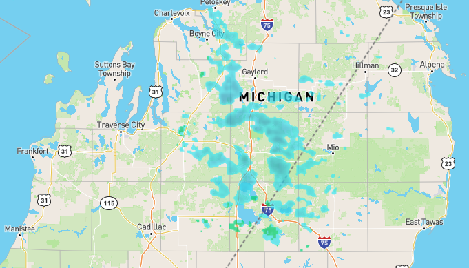
-
11/19 - 11/22 Arklatex Low - Great Lakes/OHV Cutter???
jaster220 replied to Tom's topic in East of the Rockies
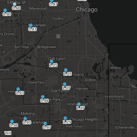
Not too far off the forecasted 0.5-1" issued by DTX for this event, but at 0.47" here it certainly was opposite of what I was hoping for. As per usual/typical with these larger S Streamers, the best forcing & duration bisected SMI in a strip from the bottom of Lake Michigan NE towards Saginaw Bay. Along that axis you can find the 1"+ totals I was hoping for here. It also appears that some of the larger numbers put up were in those two regions and likely the lake waters with a NE wind made some contribution. @Tom Looks like the slight "bump" N in the jet stream would've been winter magic for a good portion of Chicago. The SW side put up some of the highest numbers. This reminds me a bit of the 2/24-25 2016 storm that @Hoosier was referring to from the strong Nino analogs.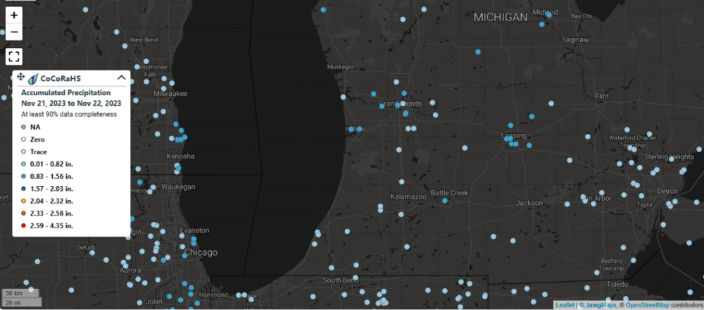
-
November 2023 Observations and Discussion
jaster220 replied to westMJim's topic in East of the Rockies
Hmm. I just read their AFD written by Duke and he sounded quite convinced there will be something happening. -
November 2023 Observations and Discussion
jaster220 replied to westMJim's topic in East of the Rockies
I see my sister out in far SWSD is under a Winter Storm Watch now. They thought that the earlier storm would hit them, but it ended up a bit too far N. Maybe this will work out for them. -
Just looking at your Top-10 driest, most of those were good to great over this way.
-
11/19 - 11/22 Arklatex Low - Great Lakes/OHV Cutter???
jaster220 replied to Tom's topic in East of the Rockies
APX mentioning it was on their radar too but just virga. Single digit temps in Canada feeding cold air into this system's leading edge making it a close call. -
11/19 - 11/22 Arklatex Low - Great Lakes/OHV Cutter???
jaster220 replied to Tom's topic in East of the Rockies
From an APX update


