westcoastexpat
-
Posts
1175 -
Joined
-
Last visited
Everything posted by westcoastexpat
-

PNW March 2023 Weather Discussion (2012 Redux)
westcoastexpat replied to Requiem's topic in West of the Rockies
You pay the price with uncomfortably hot summers in a continental climate tho -
PNW March 2023 Weather Discussion (2012 Redux)
westcoastexpat replied to Requiem's topic in West of the Rockies
I hate it to be honest. If snow isn't on the table, I'd much rather some warmer weather than pointless cool damp weather this late into the season. -
PNW March 2023 Weather Discussion (2012 Redux)
westcoastexpat replied to Requiem's topic in West of the Rockies
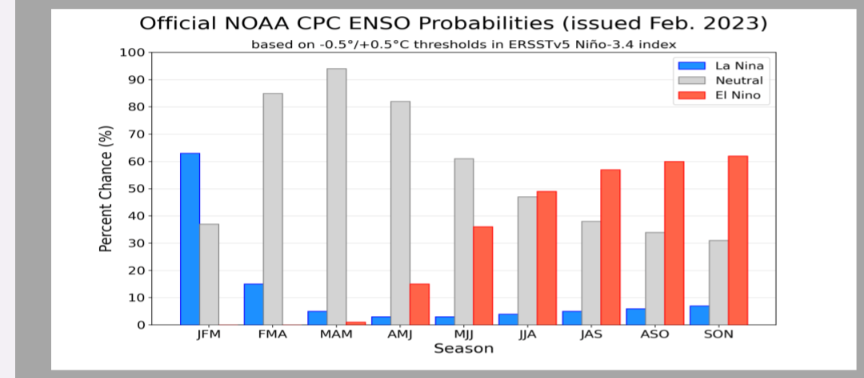
Odds are currently 65% for Nino, 30% for neutral - so it definitely could be neutral but weak Nino very much on the table -
It's been snowing pretty much all day here but nothing has stuck, temps have been around 34 and it's just too mild with everything melting on contact for hours! No complaints though, got a 14" dump just before Christmas and 8" yesterday. Winter gets a B+ from me. And it hasn't been that cold which is good for me as I'm not a fan.
-
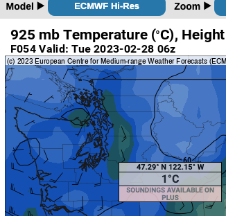
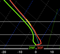
Always remember to look aloft! - 925 mb height temps are above freezing on the Euro. Can see a fairly definitive warm nose aloft that would "slopify" the snowflakes as they move through that layer.
-
Yes good point - it will be wet. 10:1 ratio will give misleadingly high totals. 5:1 much more realistic given the temperature profile.
-
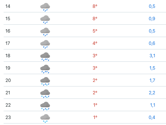
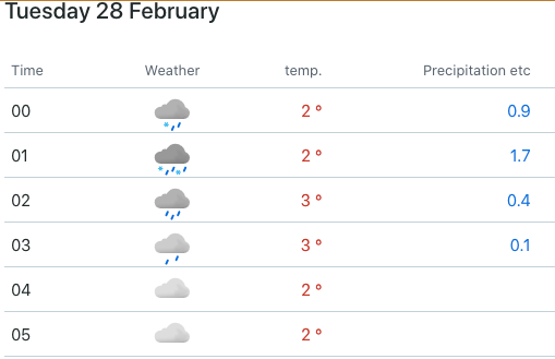
Here is the hourly Euro output for Seattle (Monday PM into Tuesday AM), if this helps:
-
Hmmm not sure about that? Latest Euro spitting out an inch or two of slop - and that's assuming every wet flake mixed with rain sticks to the ground.
-
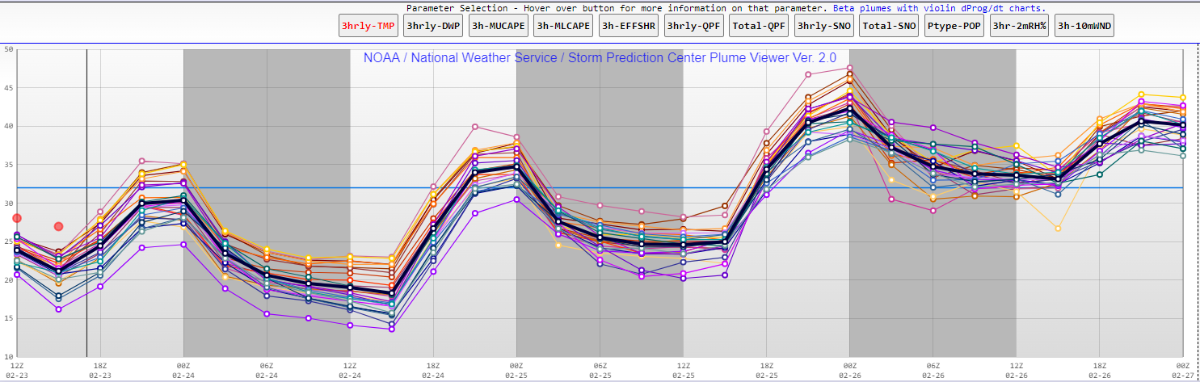
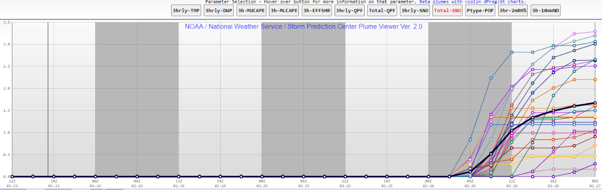
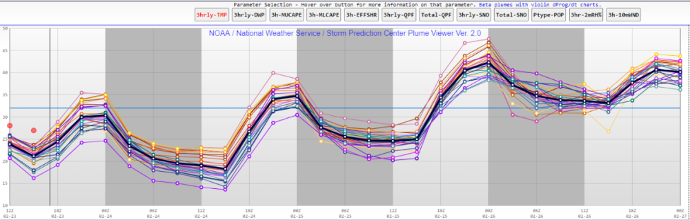
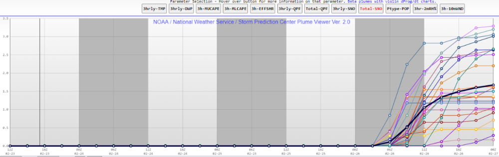
SREF ensemble plumes agree too. Three different physics cores all with similar solutions is tough to ignore.
-
SREF ensemble plumes showing that temperatures have stayed warmer than forecast this morning at SEA. Looking toward the weekend, plumes are showing trace-2.5 inches of snow for SEA. Notable that no members have zero, so everyone should see some snow. Although these plumes default to a 10:1 ratio which is unlikely given temperatures will be around the freezing mark, so may need to shave off about 25% of these amounts.
-
La Nina is definitely just about done. CPC has raised odds of Nino next winter to 65%. Ensembles definitely hinting at a strong +PNA sometime in mid March. An early spring would be great, I've never been a fan of cool springs as it delays the trees!
-
Are you really that surprised that folks aren't giddy about highs of 40 and lows of 30? Your obsession with seasonal anomalies is... interesting!
-
Yes that's exactly it. Highs of 40 and lows of 30 may be anomalously cool for this time of year but I wouldn't call it a solid stretch of winter aside from the few days later this week and likely another few days in early March.
-
Not sure you can really say we will have two weeks of solidly cold weather. At this point, it looks like two days of solidly cold weather before a return to mostly normal and another chance of a couple more cold days in early March.
-
I guess it depends on your definition of a bust. Most people couldn't care less about a couple of mornings in the low to mid 20s next week. At this point that's the only certain outcome.
-
PNW January 2023 Observations and Discussion
westcoastexpat replied to Requiem's topic in West of the Rockies
HRRR seems to be nailing temps tonight. Would be surprised to see many stations go into the teens - likely low to mid 20s for most. Ah well, another January in the trash. February will probably end up below normal but snow chances seem low and probably more boring quick hitters like this one. -
PNW January 2023 Observations and Discussion
westcoastexpat replied to Requiem's topic in West of the Rockies
Agreed, I don't care about a negative anomaly for a 28 day period. I care about an actual winter event with snow. -
PNW January 2023 Observations and Discussion
westcoastexpat replied to Requiem's topic in West of the Rockies
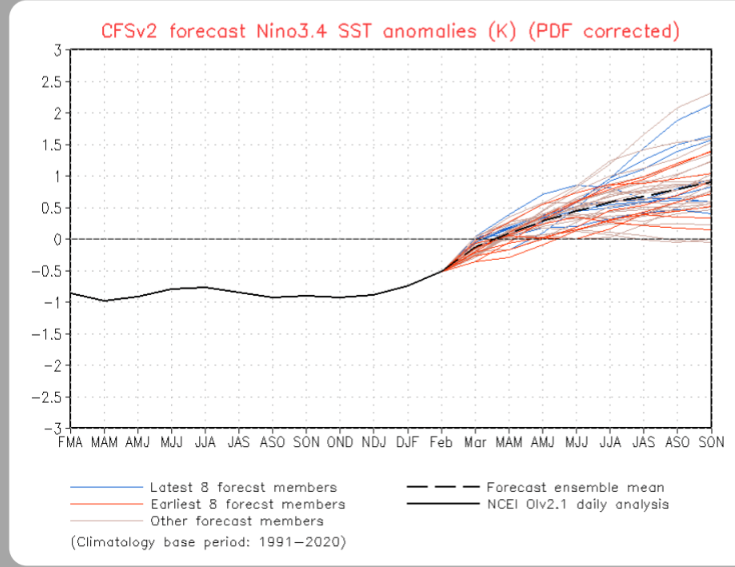
The transition from Nina to Nino typically starts at Nino 1+2 and transitions westward with 3.4 being last to warm. -
PNW January 2023 Observations and Discussion
westcoastexpat replied to Requiem's topic in West of the Rockies
I mean there are signs.. CPC probabilistic guidance at over 50% odds of El Nino by October, much higher odds than those for a neutral year. And following three Ninas, a Nino soon should be pretty much guaranteed within the next two winters. -
PNW January 2023 Observations and Discussion
westcoastexpat replied to Requiem's topic in West of the Rockies
I think the writing is in the wall that round 2 will be further east than round 1. GEFS is a much poorer ensemble, so I would bank on the EPS at this point, as much as I wish it wasn't the case. Oh well, another dud of a January but the late December blast really was special. -
Deterministic models have little weight at that forecast range... You should look for trends in the ensembles outside of Day 6 to have any significance
-
Woke up to about a foot of snow here in metro Vancouver. Really overperformed. What an epic snowfall
-
I'm not so sure, I find the GFS has significant resolution issues for the PNW and handles lowland snow rather poorly (at least when precip type is a factor) It was easily the worst model for this recent event in Vancouver
-
November 2022 PNW weather Discussion. #NoRidgeNovember
westcoastexpat replied to Iceresistance's topic in West of the Rockies
Received 6" of snow here in metro Vancouver. Beautiful sunshine today and bright snow everywhere. Love it! And looking nice and cold here tomorrow - should stay below freezing all day tomorrow and hit 15 F. -
November 2022 PNW weather Discussion. #NoRidgeNovember
westcoastexpat replied to Iceresistance's topic in West of the Rockies
The issue here is that this is a 10:1 ratio. This type of snow would be likely half that ratio at least, so you're looking more like 4-6 wet inches. And since there's likely to be some rain mixing in, this output is more like a few wet inches on the ground. Models are notoriously misleading with accumulation outputs. If you look at just the snow output, it'll seen like every flake will stick to groubd. Better to look at the QPF and apply the most likely ratio.