


Hawkeye
-
Posts
7173 -
Joined
-
Last visited
-
Days Won
17
Everything posted by Hawkeye
-

11/19 - 11/22 Arklatex Low - Great Lakes/OHV Cutter???
Hawkeye replied to Tom's topic in East of the Rockies
Aannnd, it's gone. -
November 2023 Observations and Discussion
Hawkeye replied to westMJim's topic in East of the Rockies
The party is over after this weekend. Mid next week will be a big slap to the face. -
November 2023 Observations and Discussion
Hawkeye replied to westMJim's topic in East of the Rockies
Models just keep going drier and drier. We may not get any precip for the first three weeks of November. -
November 2023 Observations and Discussion
Hawkeye replied to westMJim's topic in East of the Rockies
The models were teasing a good storm around here after the first week of November, but now the trend is toward a pretty dry, progressive pattern through mid month. Locations east of Iowa have a better chance of decent rain. -
NW Iowa got 3-5 inches of snow today while stuck in the 20s.
-
A little disturbance, out ahead of the front, moved through eastern Iowa early this morning. I got pretty lucky as two small, but heavy, cells moved over Cedar Rapids. I picked up a very quick 0.37". That boosts my weekly total to 1.98".
-
My rain total is a real nice 1.49". For about 5-10 minutes, late this morning, it may have been the heaviest rain of the year. I love heavy rain, but there has been so little of it this year.
-
I got 0.53" overnight. That's not terrible, but the big blob of rain vanished and split around us. Our rain came from two brief downpours at the beginning and end. Hopefully, we can get another half inch this morning.
-
Models now show the final weekend system will almost totally miss Iowa to the south. Ugh. For a week models showed several waves of rain across Iowa, producing widespread 2-3". Instead, the Thursday wave will be the only rain we get over the entire week.
-
Ugh!!! This week of widespread heavy rain is going down the toilet. Round #1, today, missed north. Round #2, the tropical remnants, will mostly miss south. Round #3, the frontal flare-up, will miss well north. Round #4, the main low, will likely drop the best rain nw. Thank God Cedar Rapids got hit good by the last wet system, because this week is trending more like the rest of 2023.
-
This week may end up being much drier than expected around here. Today's wave missed north, the tropical remnants should mostly miss south, the Tuesday night front flare-up misses north, then the main low mostly misses north. The overrunning event late in the weekend is our best hope for anything decent.
-
Recent EPS runs ticked down with rain totals across the region, but this morning's run is the wettest so far.
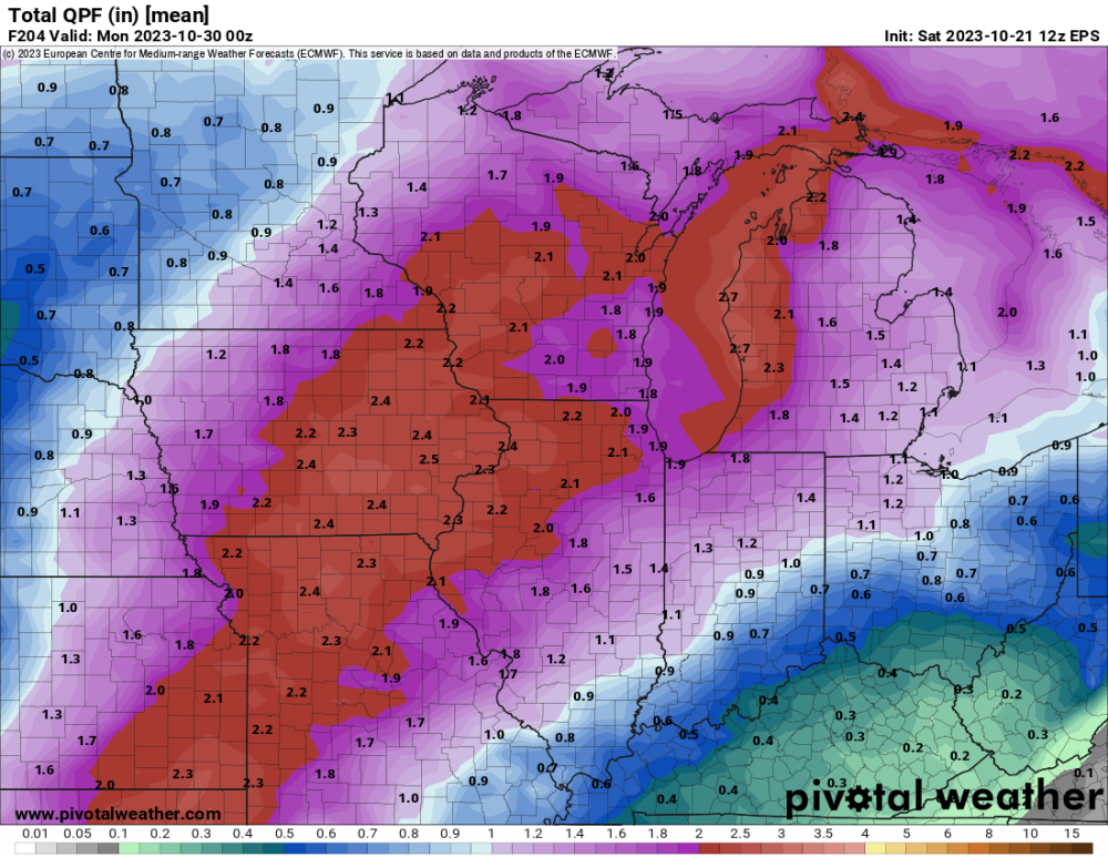
-
The 12z Euro also trended back toward the GFS.
-
The 12z Canadian and UK have trended back toward the western trough scenario.
-
The reason for the widening model differences is how each handles the northeast Pacific. The models (mostly just the GFS now) that dig the second trough into the west have a Gulf of Alaska ridge that separates the diving sw Canada energy from a big system out in the Pacific. What more models are trending to now, though, is the ridge gets pinched off, so the diving sw Canada energy and the Pacific energy connect and interact. This interaction prevents the sw Canada energy from digging further.
.thumb.gif.ea7175e128be935fcaa41b2a6a846851.gif)
-
I'm not liking the trend of some of the models. The GFS suddenly lost the western trough (the one behind the southwest cutoff) a couple days ago, but it is back now. However, the Canadian has no trough at all over the west, instead showing a fast wnw flow over the northern US, which does not allow the southwest cutoff low to lift northeast and totally screws the big rain event around here. Unfortunately, the UK has now also shifted from a western trough to garbage, just like the Canadian. Last night's Euro showed a hint of this as well, but did not go all the way. It's quite possible the big event could vanish.
-
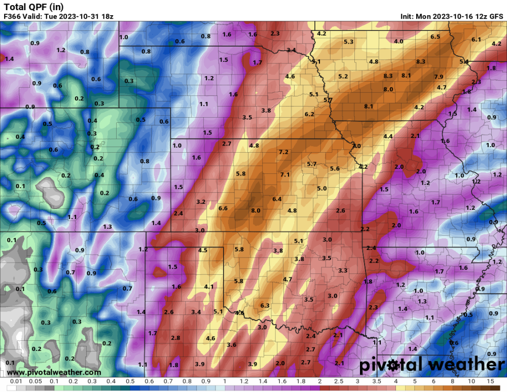
This is what we need to bust the drought. The GEFS and EPS qpf mean have been steadily rising late in the month as models are trying to shift to a western trough, with tropical moisture being pumped northward. 12z GFS - Obviously an extreme run, but fun to look at.
-
I'm certainly not ready for cold and snow, yet, but 2023 has been SO boring, it's nice to be back in big storm mode. A couple more big rain systems before winter would be nice.
-
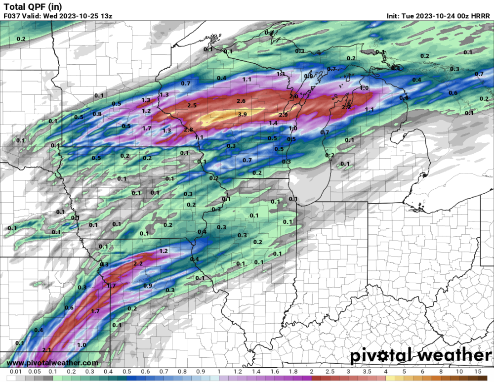
My Wed-Fri total is 3.06". 4+" fell just barely west of me, from the far west to nw side of Cedar Rapids. My 3.06" easily beats any MONTH since March.
-
I had 0.58" today up until the evening line moved in. Since then, I've received another 1+". My total since late Wednesday is now over 3". This is, by far, the biggest precip event of the year for Cedar Rapids.
-
Every model this morning has at least one inch of rain falling here this evening. If the line pivots over us two inches is possible.
-
Yeah, it looked like there were a lot more dry pockets moving through the Sioux Falls area than models predicted. The Sioux Falls radar precip accum looks pretty bare from Sioux Falls northward. Speaking of which, there are lot of locations in southern Iowa that have received little to no rain. Models badly missed on that area. I was very fortunate to be under the first wave of rain near the warm front late Wednesday. Regarding my area, this morning's cold front was a dud. Most models had been predicting near an inch from it, but the rain was late to develop and organize, so I only got 0.22". Now, most models are predicting a good line to form north of the low this afternoon and evening, which could drop good rain on CR. We'll see. My Wed-Fri total is currently 1.53".
-
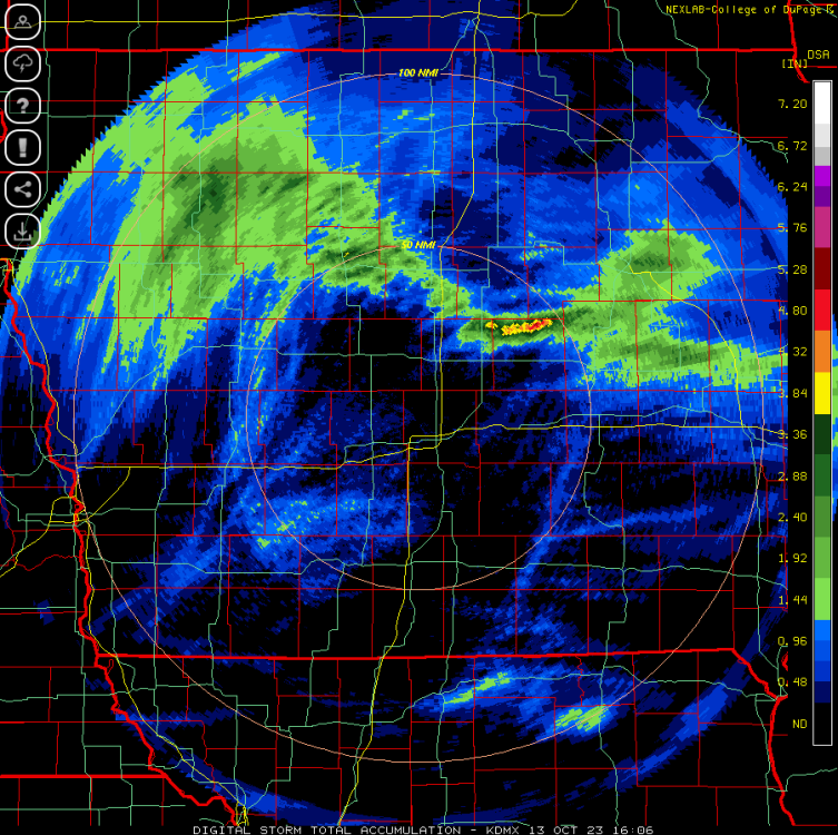
I got 1.24" as the storm train set up just far enough south to hit Cedar Rapids. Not far to the southwest totals drop off quickly. Unfortunately, the Friday morning surge of good rain, along the cold front, has mostly been shifted eastward toward the river and northern Illinois. Then, the final wave, with the low itself, should drop a narrow band of good rain somewhere around here, but models do not agree where.
-
My total is about 1.15" so far. We could get a bit more tonight. It would be great if we could double the total by the end.
-
Some cells with decent hail have popped in the Cedar Rapids/Iowa City area.


.gif.86e918ace4880fc95c0aff9b8423f712.gif)


