Hawkeye
-
Posts
7160 -
Joined
-
Last visited
-
Days Won
17
Everything posted by Hawkeye
-

March 31st - April 2nd Potent Plains Storm
Hawkeye replied to Clinton's topic in East of the Rockies
The rain is beginning to mix. Radar shows the switch to snow on my door step. I've received 0.76" since midnight. Iowa City got a 1" head start on CR. -
March 31st - April 2nd Potent Plains Storm
Hawkeye replied to Clinton's topic in East of the Rockies
Timmy Supercell had a nasty line move through his town a couple hours ago. An automated station not too far away recorded a 90 mph wind gust. -
March 31st - April 2nd Potent Plains Storm
Hawkeye replied to Clinton's topic in East of the Rockies
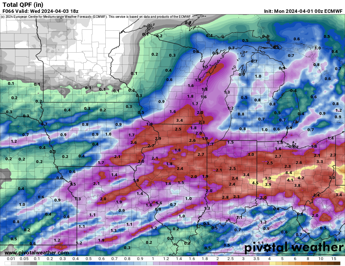
It appears there could be a swath of 2" of precip from Iowa City northeastward, with a sharp edge to the heavier precip near Cedar Rapids. 1" would be nice. -
March 31st - April 2nd Potent Plains Storm
Hawkeye replied to Clinton's topic in East of the Rockies
The HRRR has shifted the heavier rain back southeast, out of my yard again. I'm not surprised. All the big convection from Missouri through Illinois will probably pull the whole thing e/se.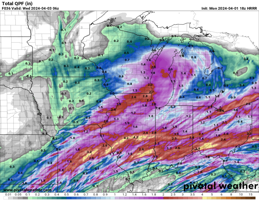
-
Today's op runs of the GFS and Euro are very different.
-
March 31st - April 2nd Potent Plains Storm
Hawkeye replied to Clinton's topic in East of the Rockies
Models had been showing some good rain moving across my area today, but that appears to have crapped out. I have to hope the main low can throw precip far enough nw to give me something. -
March 31st - April 2nd Potent Plains Storm
Hawkeye replied to Clinton's topic in East of the Rockies
06z Euro.... a bit more nw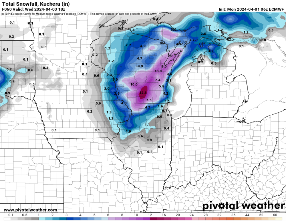
-
March 31st - April 2nd Potent Plains Storm
Hawkeye replied to Clinton's topic in East of the Rockies
The models are trending toward a more nw low track. A few models even get my area into the defo zone and drop 1+" of precip. I need Monday's convection to not push all of this farther southeast.
-
March 31st - April 2nd Potent Plains Storm
Hawkeye replied to Clinton's topic in East of the Rockies
I received about 0.32" this evening. -
March 31st - April 2nd Potent Plains Storm
Hawkeye replied to Clinton's topic in East of the Rockies
Models are all over with regard to rain totals for my area... anything from 0.2" to 1.2". Given the setup, with a lot of convection to the south, I'd lean toward the low end of the range. -
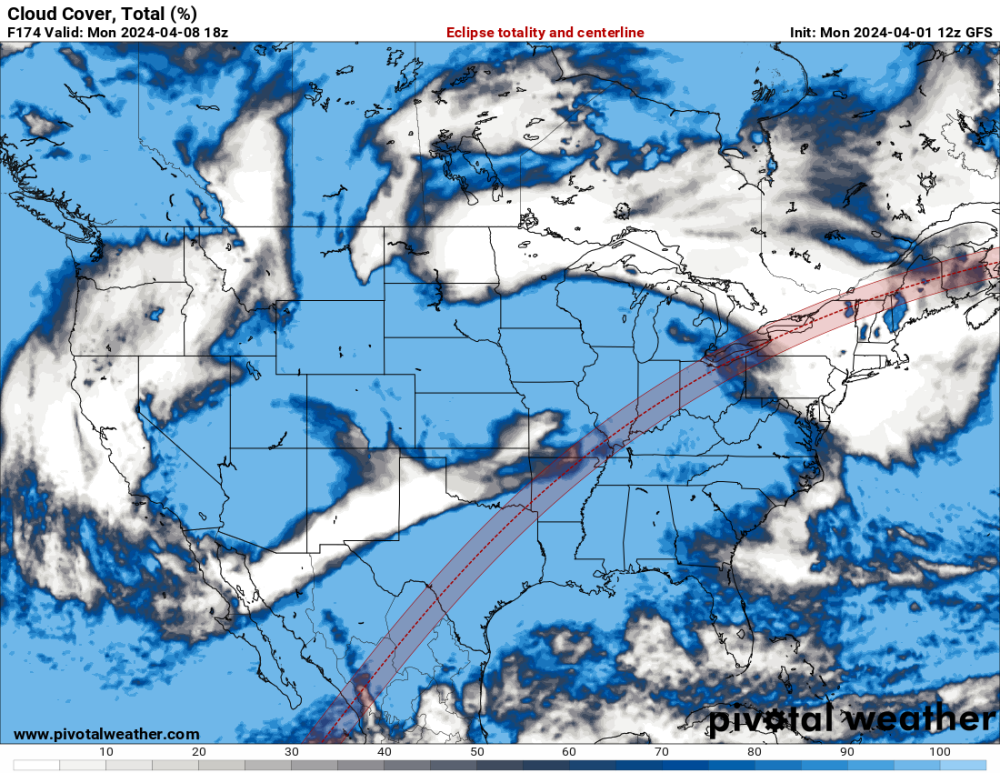
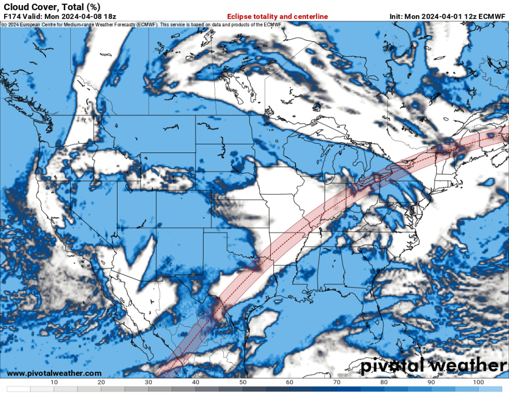
The latest models suggest that the worst part of the path for viewing may be Texas as a storm system begins to develop and pull moisture into the region.
-
March 31st - April 2nd Potent Plains Storm
Hawkeye replied to Clinton's topic in East of the Rockies
As expected, the GFS just completely caved to the south and less-amped models. Rats!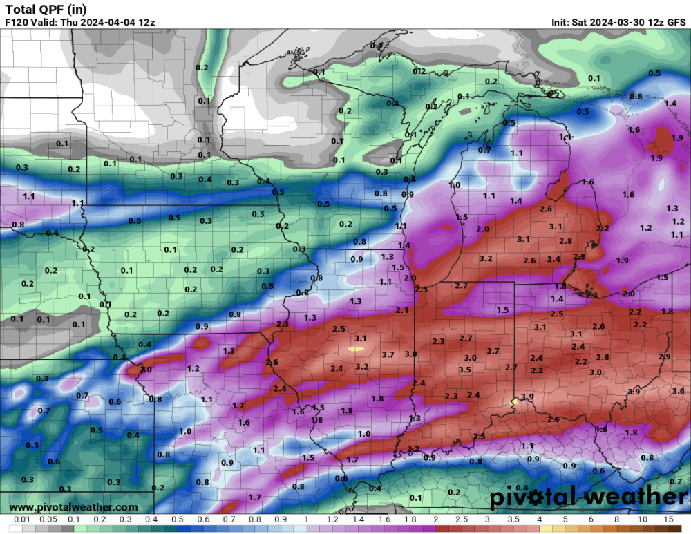
-
March 31st - April 2nd Potent Plains Storm
Hawkeye replied to Clinton's topic in East of the Rockies
The GFS is on its own. The Euro, GDPS, and ICON are all south and weaker. Once again, I'm hoping we can squeeze a half inch out of this system. It looks dry for a while after this. -
Storms are expected to develop tonight, but models have trended mostly south and east of Cedar Rapids. Northern Illinois should get some good rain.
-
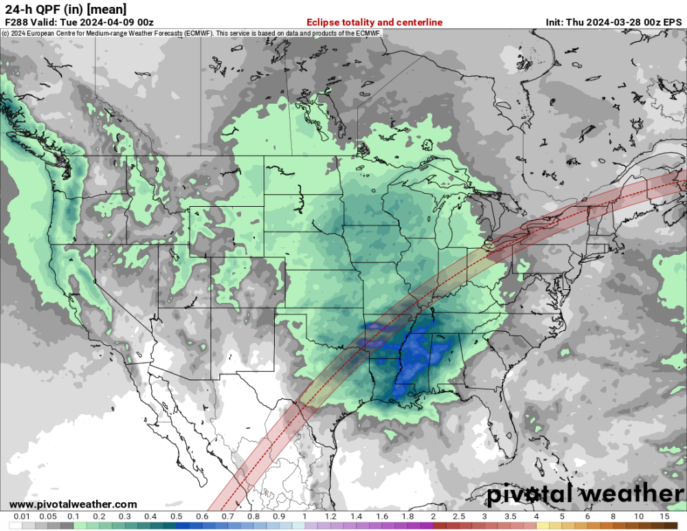
The EPS and GEFS are not promising. Both are suggesting significant storminess across the central US around April 8th.
-
3/24-3/27 Midwest/Plains Colorado Low(s)
Hawkeye replied to Minny_Weather's topic in East of the Rockies
I got a decent 0.46" this morning. One good shower dropped most of it. -
3/24-3/27 Midwest/Plains Colorado Low(s)
Hawkeye replied to Minny_Weather's topic in East of the Rockies
The models all had at least some scattered showers today that might add up to a tenth or two, but zero rain ever developed. The plume of good rain to the east/southeast stole all the moisture. -
Hopefully, the weather will cooperate. It's not necessarily the best time of year for that. Traveling to see an eclipse doesn't really interest me, but it's nice to see other people get excited. I saw there will be an eclipse in 2028 in Australia and Sydney will be exactly in the middle of the totality path. That's pretty good luck.
-
The 5.9" of snow we got a few days ago is completely gone this morning.
-
3/24-3/27 Midwest/Plains Colorado Low(s)
Hawkeye replied to Minny_Weather's topic in East of the Rockies
0.01" of rain here so far. Maybe we can squeeze out a few tenths later.. -
Models had been showing a continuation of the storm train into April, with at least two more strong troughs ejecting out of the west. That is all fading fast as the models are, instead, turning the flow to the northwest.
-
It snowed for three hours, so we got 2"/hr rate avg.
-
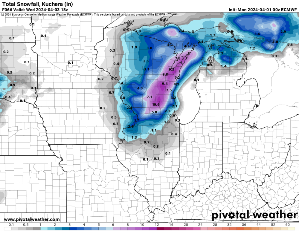
I finished with 5.9" on the west side of Cedar Rapids. My liquid total is a much-needed 0.74". The very max part of the band dropped close to 7" just a hair north of me, but I am super thrilled with what I got.
-
7" now being reported in Shellsburg, just nw of Cedar Rapids, and Tama, two counties west of CR. Major kudos to the models that shifted south to the hw30 corridor through CR.
-
The snow is ripping pretty good here. The ground is completely covered. I'm guessing we might get a couple inches.