gabel23
-
Posts
2304 -
Joined
-
Last visited
-
Days Won
5
Everything posted by gabel23
-

April 2022 Observations & Discussions
gabel23 replied to Iceresistance's topic in East of the Rockies
Just a bit of snow being forecasted.... ...WINTER STORM WATCH IN EFFECT FROM TUESDAY MORNING THROUGH THURSDAY MORNING... * WHAT...Heavy snow and blizzard conditions possible. Total snow accumulations between 10 and 20 inches possible. Winds could gust as high as 40 mph. * WHERE...Most of western and central North Dakota. -
April 2022 Observations & Discussions
gabel23 replied to Iceresistance's topic in East of the Rockies
That's is completely unbelievable. WOW. -
April 2022 Observations & Discussions
gabel23 replied to Iceresistance's topic in East of the Rockies
From what I have heard from the news the fire still isn't contained. Just sickening what's going on with this situation. The plume that was showing up on radar was the most intense reflectivity I have ever seen in a fire. -
April 2022 Observations & Discussions
gabel23 replied to Iceresistance's topic in East of the Rockies
You can see that real good on radar scope also. Been getting hit by off and on grapuel showers earlier than transitioned to snow showers. Then in between that we have blowing dust. Just a crazy time around these parts.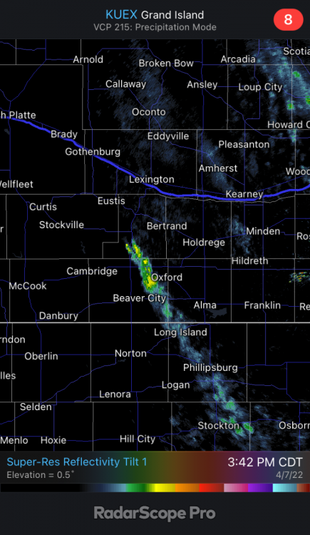
-
April 2022 Observations & Discussions
gabel23 replied to Iceresistance's topic in East of the Rockies
Kind of like OAX..... Southwesterly flow increases early next week as troughing digs across the Rockies. There are still many uncertainties within the deterministic and ensemble solutions, but the large scale pattern would favorable a stormy few days. -
I’ve been in gap the whole time and sitting at .04”. Hoping tonight’s precipitation pans out.
-
I’m hoping that blizzard warning gets expanded into our area by the morning! At least we would have that for us this year…
-
Here we go, just put into a WWA. ...WINTER WEATHER ADVISORY IN EFFECT FROM 1 AM TO 1 PM CDT TUESDAY... * WHAT...Snow expected. Total snow accumulations of 1 to 3 inches, with locally higher amounts of 4 inches. North winds gusting as high as 55 mph. * WHERE...Portions of north central Kansas and central, east central and south central Nebraska. * WHEN...From 1 AM to 1 PM CDT Tuesday. * IMPACTS...Plan on slippery road conditions. The hazardous conditions could impact the morning commute. Strong winds could cause tree damage. * ADDITIONAL DETAILS...The combination of strong winds and falling snow can lower visibilities to less than 1 mile at times. Rain will change to snow from northwest to southeast. Some locations south and east of the tri-cities may not transition to snow until near dawn.
-
Blizzard warning for the panhandles of Texas and Oklahoma. Hoping this storm throws us a surprise up in my area! Actually I don't care, I just want some precip in the worst way. ...BLIZZARD WARNING IN EFFECT FROM 7 PM THIS EVENING TO 10 AM CDT TUESDAY... * WHAT...Blizzard conditions expected. Total snow accumulations up to 3 to 5 inches. Winds gusting as high as 65 mph. * WHERE...In Oklahoma, Texas and Beaver Counties. Portions of the southwest, central and northeast Texas Panhandle. * WHEN...From 7 PM this evening to 10 AM CDT Tuesday. * IMPACTS...Plan on slippery road conditions. The hazardous conditions could impact the Monday evening and Tuesday morning commutes. Strong winds could cause extensive damage to trees and power lines.
-
Family and I was coming home from Great Wolf Lodge in KC today and seen two wild fires on our way home. One of them I seen farmers disking out in front 2 miles trying to prevent the spread. We need some sort of soaking in the worse way.
-
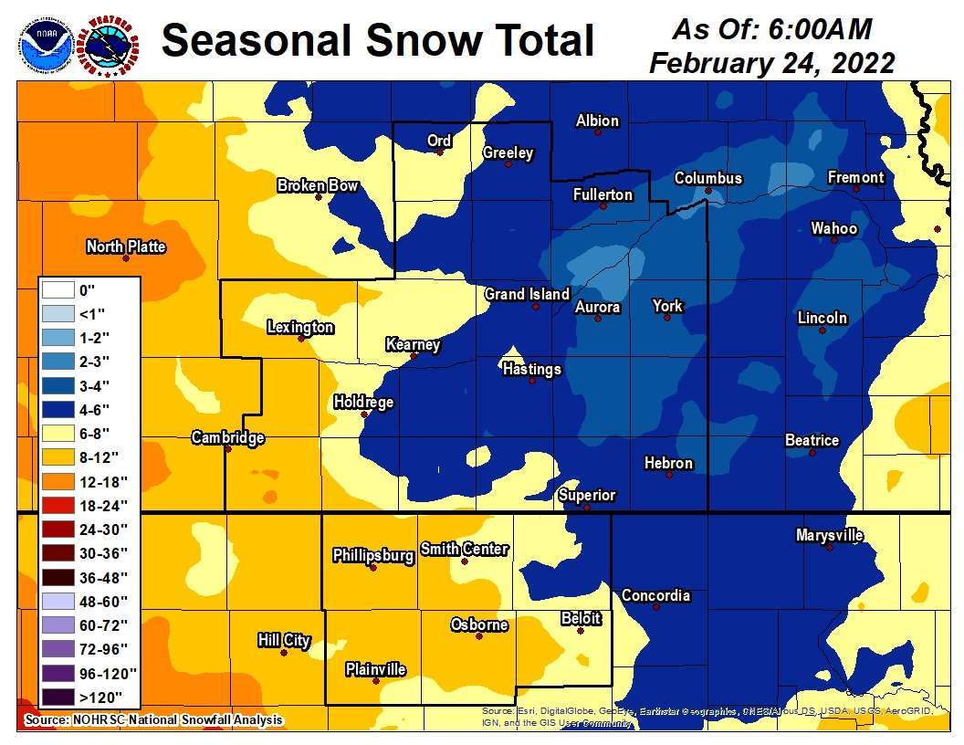
Nice blue bullseye right through my area. This map is pretty spot on as I'm sitting at less than 5" for the year.
-
Well that too. I’m just going off with how the winter has been for my area!
-
This winter can die a slow death. Been cut off and on the edge of every storm and missed in all directions. With this miss I should finish the year off with less than 5” of snow. Wohoo to futility!
-
Ouch I’ve seen this movie before this year. That dreaded northeast wind and dry air killing it for me.
-
The one thing the models have done an amazing job at this year is the consistent shift as we near the event. We have seen it all year.
-
I’m not surprised. I’ll now be rooting for a miss and an all time record season low of snow. Let this god forsaken winter end already.
-
This afternoon's runs have not been kind to my area. I have been missed all winter so far and wouldn't be shocked if I get missed again. These clippers tend to throw a lot of curve balls before the event so I'm sure more changes are to come.
-
Ended up with 2". Nice little surprise for once; we started the day off with a 50% chance of snow and forecast said little to no snow accumulation.
-
Coming down really good and ground is close to being covered. It took a bit to fight through the dry air. I’m anxious to see if the heavier band to my west stays together.
-
Yeah was planning on going down Wednesday thru Friday. Plans might change now! Glad the ground is covered hoping for the same thing here.
-
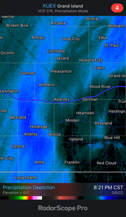
@CentralNebWeather that’s a nice looking band coming your way. Hopefully it’s strong enough to whiten the ground and can stay together for my area!
-
February 2022 Observations and Discussions
gabel23 replied to Grizzcoat's topic in East of the Rockies
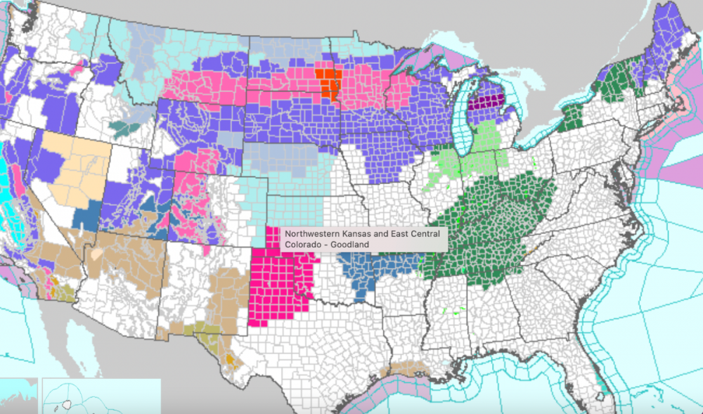
Well good sign with the following winter; that line shoots straight up! The silver lining, even though we have to wait a year, is there will be no way we get less than 10" next year. We have never had back to back winters with less than 10" in recorded history. Typically you see an average or above average after a winter we have experienced. -
February 2022 Observations and Discussions
gabel23 replied to Grizzcoat's topic in East of the Rockies
Nice glory hole right through SC Nebraska. I'm sitting at 4" for the year. Last year at this time was at 49".
-
February 2022 Observations and Discussions
gabel23 replied to Grizzcoat's topic in East of the Rockies
It's insane up there! I have been looking at their news and they had a major pile up on I-94 today. Fargo has experienced blizzard warning criteria for 12+ hours. Heavy snow and temps below zero to boot! This is number 9 according to one source I have seen. I would love to see what it looks like with drifts around shelter belts; if they have them up there I'm not sure?! If they do they have to be approaching 30-40 feet with all the snow and blowing snow so far this year. They had their first blizzard back in November and it hasn't let up. -
February 2022 Observations and Discussions
gabel23 replied to Grizzcoat's topic in East of the Rockies
It's becoming comical. Everything all around Nebraska experiencing winter weather. Then throw in a winter storm watch down to our southeast why don't ya. I would be shocked if we receive any snow the rest of the winter we are jinxed this year for sure.